1. The document discusses river morphology and provides definitions of key river-related terms such as perennial, ephemeral, and intermittent rivers. It also describes the main functions of rivers.
2. River morphology is introduced as the study of river forms, patterns, and the processes that develop them. Key river morphological elements that are discussed include channel geometry, pattern, grade, and processes like erosion, transportation, and deposition.
3. The importance of understanding sediment transport processes for river management is highlighted. Factors influencing watershed characteristics and the effect of watershed shape on runoff flow are also examined.
Reservoir Planning: Introduction; Investigations for reservoir planning; Selection of site for a reservoir; Zones of storage in a reservoir; Storage capacity and yield; Mass inflow curve and demand curve; Calculation of reservoir capacity for a specified yield from the mass inflow curve; Determination of safe yield from a reservoir of a given capacity; Sediment flow in streams; Life of reservoir; Reservoir sediment control; flood routing. Various types of Spillways and design.
Reservoir Planning: Introduction; Investigations for reservoir planning; Selection of site for a reservoir; Zones of storage in a reservoir; Storage capacity and yield; Mass inflow curve and demand curve; Calculation of reservoir capacity for a specified yield from the mass inflow curve; Determination of safe yield from a reservoir of a given capacity; Sediment flow in streams; Life of reservoir; Reservoir sediment control; flood routing. Various types of Spillways and design.
Hec ras flood modeling little river newburyportWilliam Mullen
This narrated PowerPoint presentation describes a HEC-RAS 2-D unsteady-flow flood model set up for the tidally-influenced Little River in Newburyport and Newbury, Massachusetts. It describes the steps in developing inputs to the HEC-RAS model including using HEC-HMS rainfall-runoff modeling and GIS in developing inputs to HEC-HMS. The HEC-RAS model was calibrated using the Mother's Day flood of May 2006. The HEC-RAS model may be used to evaluate impacts associated with proposed changes in culvert sizes or changing embankment elevations near or at problem flood areas and can also be used to determine the changes in river hydraulics associated with sea level rise and climate change.
Topics:
1. Reservoir Classification
2. Investigations
3. Selection of Site for Reservoir
4. Zones of Storage
5. Storage Capacity and Yield
6. Mass Inflow Curve & Demand Curve
7. Calculation of Reservoir Capacity
8. Reservoir Sedimentations
9. Life of Reservoir
10. Selection of Dam
Stream Morphology
Investigation
Manual
ENVIRONMENTAL SCIENCE
Made ADA compliant by
NetCentric Technologies using
the CommonLook® software
STREAM MORPHOLOGY
Overview
Students will construct a physical scale model of a stream system
to help understand how streams and rivers shape the solid earth
(i.e., the landscape). Students will perform several experiments
to determine streamflow properties under different conditions.
They will apply the scientific method, testing their own scenarios
regarding human impacts to river systems.
Outcomes
• Design a stream table model to analyze the different
characteristics of streamflow.
• Explain the effects of watersheds on the surrounding
environment in terms of the biology, water quality, and economic
importance of streams.
• Identify different stream features based on their geological
formation due to erosion and deposition.
• Develop an experiment to test how human actions can modify
stream morphology in ways that may, in turn, impact riparian
ecosystems.
Time Requirements
Preparation ...................................................................... 5 minutes,
then let sit overnight
Activity 1: Creating a Stream Table ................................ 60 minutes
Activity 2: Scientific Method: Modeling Human Impacts
on Stream Ecosystems .................................. 45 minutes
2 Carolina Distance Learning
Key
Personal protective
equipment
(PPE)
goggles gloves apron
follow
link to
video
photograph
results and
submit
stopwatch
required
warning corrosion flammable toxic environment health hazard
Key
Personal protective
equipment
(PPE)
goggles gloves apron
follow
link to
video
photograph
results and
submit
stopwatch
required
warning corrosion flammable toxic environment health hazard
Table of Contents
2 Overview
2 Outcomes
2 Time Requirements
3 Background
9 Materials
10 Safety
10 Preparation
10 Activity 1
12 Activity 2
13 Submission
13 Disposal and Cleanup
14 Lab Worksheet
18 Lab Questions
Background
A watershed is an area of land that drains
any form of precipitation into the earth’s water
bodies (see Figure 1). The entire land area that
forms this connection of atmospheric water to
the water on Earth, whether it is rain flowing into
a lake or snow soaking into the groundwater, is
considered a watershed.
Water covers approximately 70% of the earth’s
surface. However, about two-thirds of all water
is impaired to some degree, with less than
1% being accessible, consumable freshwater.
Keeping watersheds pristine is the leading
method for providing clean drinking water to
communities, and it is a high priority worldwide.
However, with increased development and
people flocking toward waterfront regions to live,
downstream communities are becoming increas-
ingly polluted every day.
From small streams to large rivers (hereafter .
Assignment on: Runoff and flooding (Drainage Pattern, Stream Flow Velocity, R...Mozakkir Azad
Water is one of our most important natural resources. Without it, there would be no life on earth. The supply of water available for our use is limited by nature. Although there is plenty of water on earth, it is not always in the right place, at the right time and of the right quality. Adding to the problem is the increasing evidence that chemical wastes improperly discarded yesterday are showing up in our water supplies today. Hydrology has evolved as a science in response to the need to understand the complex water systems of the Earth and help solve water problems. Hydrologists play a vital role in finding solutions to water problems, and interesting and challenging careers are available to those who choose to study hydrology
Sediment Source and Transport in River Channels: Implications for River Struc...theijes
Rivers are important resources that play the role of life sustenance in nature by providing environmental, cultural and economic benefits including municipal water use, irrigation, hydropower, navigation, fishing and recreation. Since they are the corridors connecting terrestrial environment to the ocean realm, they always transport and accumulate sediments. Knowledge and understanding of sediment characteristics, channel processes, process of sediment source and transport in river channels is vital in modeling and managing rivers in terms of how they both transport and impact engineering structures erected on rivers. Although, ongoing research is beginning to fill in some of these gaps through the use of laboratory experiments and mathematical models, this has not been matched by sufficient progress in measuring and quantifying the bifurcation process in natural river channels, very often because natural rivers are far harder to study and the technology required still remains unavailable. When the rate of sediment influx is high along river channels, reservoirs in dams are filled up with sediment which might need dredging to remove the sediments. Also turbine blades of power plants are considerably disturbed as a result of sediment particles deposited on the blades; flow in culverts and around bridge piers are exposed to erosion of the bed thereby exposing the foundation. Problems arising from sediment transport and deposition can be mitigated by selecting suitable cross sections for the measurement of sediment flow rate parameters and removal of the sediment which would lead to the reduction of negative impacts on the river structures.
36002 Topic SCI 207 Our Dependence upon the EnvironmentNumber.docxrhetttrevannion
36002 Topic: SCI 207 Our Dependence upon the Environment
Number of Pages: 2 (Double Spaced)
Number of sources: 3
Writing Style: APA
Type of document: Essay
Academic Level:Undergraduate
Category: Environmental Issues
Language Style: English (U.S.)
Order Instructions: Attached
Week 1 - Assignment 1
Stream Morphology Laboratory
[WLO: 1] [CLOs: 1, 3, 5]
This lab enables you to construct a physical scale model of a stream system to help you understand how streams and rivers shape the landscape, and how human actions can affect river ecosystems. This lab is done with materials that you will need to supply; the list of items you will need to obtain is in the Stream Morphology Investigation ManualPreview the document.
The Process:
Take the required photos and complete all parts of the assignment (calculations, data tables, etc.). On the “Lab Worksheet,” answer all of the questions in the “Lab Questions” section. Finally, transfer all of your answers and visual elements from the “Lab Worksheet” into the “Lab Report.” You will submit both the “Lab Report” and the “Lab Worksheet” to Waypoint.
The Assignment:
Make sure to complete all of the following items before submission:
Before you begin the assignment, read the Stream Morphology Investigation ManualPreview the document and review The Scientific Method presentation video.
Complete Activity 1 and Activity 2 using the materials that you supply. Photograph each activity following these instructions:
When taking lab photos, you need to include in each image a strip of paper with your name and the date clearly written on it.
Complete all parts of the Week 1 Lab WorksheetPreview the document and answer all of the questions in the “Lab Questions” section.
Transfer your responses to the lab questions and the data tables and your photos from the “Lab Worksheet” into the Lab Report TemplatePreview the document.
Submit your completed “Lab Report” and “Lab Worksheet” through Waypoint.
ENVIRONMENTAL SCIENCE
Stream Morphology
Investigation Manual
STREAM MORPHOLOGY
Table of Contents
2 Overview 2 Outcomes
2 Time Requirements
3 Background
9 Materials
10 Safety
10 Preparation 10 Activity 1
12 Activity 2
13 Submission
13 Disposal and Cleanup
14 Lab Worksheet
18 Lab Questions
Overview
Students will construct a physical scale model of a stream system to help understand how streams and rivers shape the solid earth (i.e., the landscape). Students will perform several experiments
to determine streamflow properties under different conditions. They will apply the scientific method, testing their own scenarios regarding human impacts on river systems.
Outcomes
• Design a stream table model to analyze the different characteristics of streamflow.
• Explain the effects of watersheds on the surrounding environment in terms of the biology, water quality, and economic importance of streams.
• Identify different stream features based on their geological formation due to erosion an.
Runoff is that portion of the rainfall or irrigation water which leaves a field either as surface or as subsurface flow. When rainfall intensity reaching the soil surface is less than the infiltration capacity, all the water is absorbed in to the soil. As rain continues, soil becomes saturated and infiltration capacity is reduced, shallow depression begins to fill with water, then the overland flow starts as runoff.
Flowing water has the ability to dissolve the soluble mineral substances available on its way. The processes enacted by streams are called as fluvial processes. The word “fluvius” is derived from the latin word meaning “ river”. The world fluvial is used to denote the running water as streams or rivers. Fluvial processes entail the erosion, transportation, and deposition of earth materials by running water. Fluvial processes and fluvial landforms dominate land surfaces the world over, as opposed to the limited effects of glacial, coastal, and wind processes.
Democratizing Fuzzing at Scale by Abhishek Aryaabh.arya
Presented at NUS: Fuzzing and Software Security Summer School 2024
This keynote talks about the democratization of fuzzing at scale, highlighting the collaboration between open source communities, academia, and industry to advance the field of fuzzing. It delves into the history of fuzzing, the development of scalable fuzzing platforms, and the empowerment of community-driven research. The talk will further discuss recent advancements leveraging AI/ML and offer insights into the future evolution of the fuzzing landscape.
Industrial Training at Shahjalal Fertilizer Company Limited (SFCL)MdTanvirMahtab2
This presentation is about the working procedure of Shahjalal Fertilizer Company Limited (SFCL). A Govt. owned Company of Bangladesh Chemical Industries Corporation under Ministry of Industries.
Courier management system project report.pdfKamal Acharya
It is now-a-days very important for the people to send or receive articles like imported furniture, electronic items, gifts, business goods and the like. People depend vastly on different transport systems which mostly use the manual way of receiving and delivering the articles. There is no way to track the articles till they are received and there is no way to let the customer know what happened in transit, once he booked some articles. In such a situation, we need a system which completely computerizes the cargo activities including time to time tracking of the articles sent. This need is fulfilled by Courier Management System software which is online software for the cargo management people that enables them to receive the goods from a source and send them to a required destination and track their status from time to time.
Event Management System Vb Net Project Report.pdfKamal Acharya
In present era, the scopes of information technology growing with a very fast .We do not see any are untouched from this industry. The scope of information technology has become wider includes: Business and industry. Household Business, Communication, Education, Entertainment, Science, Medicine, Engineering, Distance Learning, Weather Forecasting. Carrier Searching and so on.
My project named “Event Management System” is software that store and maintained all events coordinated in college. It also helpful to print related reports. My project will help to record the events coordinated by faculties with their Name, Event subject, date & details in an efficient & effective ways.
In my system we have to make a system by which a user can record all events coordinated by a particular faculty. In our proposed system some more featured are added which differs it from the existing system such as security.
Saudi Arabia stands as a titan in the global energy landscape, renowned for its abundant oil and gas resources. It's the largest exporter of petroleum and holds some of the world's most significant reserves. Let's delve into the top 10 oil and gas projects shaping Saudi Arabia's energy future in 2024.
NO1 Uk best vashikaran specialist in delhi vashikaran baba near me online vas...Amil Baba Dawood bangali
Contact with Dawood Bhai Just call on +92322-6382012 and we'll help you. We'll solve all your problems within 12 to 24 hours and with 101% guarantee and with astrology systematic. If you want to take any personal or professional advice then also you can call us on +92322-6382012 , ONLINE LOVE PROBLEM & Other all types of Daily Life Problem's.Then CALL or WHATSAPP us on +92322-6382012 and Get all these problems solutions here by Amil Baba DAWOOD BANGALI
#vashikaranspecialist #astrologer #palmistry #amliyaat #taweez #manpasandshadi #horoscope #spiritual #lovelife #lovespell #marriagespell#aamilbabainpakistan #amilbabainkarachi #powerfullblackmagicspell #kalajadumantarspecialist #realamilbaba #AmilbabainPakistan #astrologerincanada #astrologerindubai #lovespellsmaster #kalajaduspecialist #lovespellsthatwork #aamilbabainlahore#blackmagicformarriage #aamilbaba #kalajadu #kalailam #taweez #wazifaexpert #jadumantar #vashikaranspecialist #astrologer #palmistry #amliyaat #taweez #manpasandshadi #horoscope #spiritual #lovelife #lovespell #marriagespell#aamilbabainpakistan #amilbabainkarachi #powerfullblackmagicspell #kalajadumantarspecialist #realamilbaba #AmilbabainPakistan #astrologerincanada #astrologerindubai #lovespellsmaster #kalajaduspecialist #lovespellsthatwork #aamilbabainlahore #blackmagicforlove #blackmagicformarriage #aamilbaba #kalajadu #kalailam #taweez #wazifaexpert #jadumantar #vashikaranspecialist #astrologer #palmistry #amliyaat #taweez #manpasandshadi #horoscope #spiritual #lovelife #lovespell #marriagespell#aamilbabainpakistan #amilbabainkarachi #powerfullblackmagicspell #kalajadumantarspecialist #realamilbaba #AmilbabainPakistan #astrologerincanada #astrologerindubai #lovespellsmaster #kalajaduspecialist #lovespellsthatwork #aamilbabainlahore #Amilbabainuk #amilbabainspain #amilbabaindubai #Amilbabainnorway #amilbabainkrachi #amilbabainlahore #amilbabaingujranwalan #amilbabainislamabad
TECHNICAL TRAINING MANUAL GENERAL FAMILIARIZATION COURSEDuvanRamosGarzon1
AIRCRAFT GENERAL
The Single Aisle is the most advanced family aircraft in service today, with fly-by-wire flight controls.
The A318, A319, A320 and A321 are twin-engine subsonic medium range aircraft.
The family offers a choice of engines
Student information management system project report ii.pdfKamal Acharya
Our project explains about the student management. This project mainly explains the various actions related to student details. This project shows some ease in adding, editing and deleting the student details. It also provides a less time consuming process for viewing, adding, editing and deleting the marks of the students.
Sachpazis:Terzaghi Bearing Capacity Estimation in simple terms with Calculati...Dr.Costas Sachpazis
Terzaghi's soil bearing capacity theory, developed by Karl Terzaghi, is a fundamental principle in geotechnical engineering used to determine the bearing capacity of shallow foundations. This theory provides a method to calculate the ultimate bearing capacity of soil, which is the maximum load per unit area that the soil can support without undergoing shear failure. The Calculation HTML Code included.
Sachpazis:Terzaghi Bearing Capacity Estimation in simple terms with Calculati...
Chapter one. River morphology.pptx
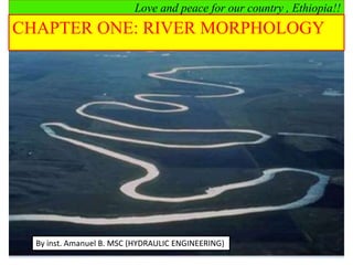
1. Love and peace for our country , Ethiopia!!
CHAPTER ONE: RIVER MORPHOLOGY
By inst. Amanuel B. MSC (HYDRAULIC ENGINEERING)
2. 1.1.1 River
River is any body of fresh water flowing from an upland source to a large lake or to
the sea, fed by such sources as springs and tributary streams.
Rivers may be classified as;
Perennial:-continuous flow (have adequate discharge though out the year,
there is dependable base flow contribution)
Ephemeral:-flows only for short period during or following precipitation
(less than 30 days per year)
Intermittent:-flow only during certain times of the year (seasonal flow,
lasts more than 30 days per year).
Rivers also have multitude of functions, which includes the following:
Social/ economic/ cultural functions
Ecological functions
1.1 Introduction
3. 1.1 Introduction
Rivers are complex dynamic systems interaction between:
Hydrodynamics,
Morphodynamics
Ecological processes.
Rivers are continuously change their forms and patterns and other
morphological characteristics in space and time due changes in:
Water discharge
Sediment discharge
The changes in water and sediment discharge may be caused by
1. Natural elements (natural forces)
Discharge is naturally variable.
2. Anthropogenic elements
Human interference in the fluvial system it includes:
4. Cont’d
1/22/2023
a. Land developments
Land clearance
Infrastructure building
Land use change
b. River developments
Hydraulic structures
River channelization
Gravel and sand mining
River morphology is the study of the forms and patterns of
rivers and the processes that developed those forms.
It is time dependent and varies particularly with discharge,
sediment input and characteristics, and with bank material
5. Cont’d
River forms and patterns:
River channel geometry
River channel pattern/ planform
River channel planform geometry
River bed grade/ slope
River morphological processes: processes due to flowing water
Erossion
Transportation
Deposition
River forms and patterns and morphological processes interact in a feedback
mechanism.
6. Cont’d
why good understanding of sediment transport process is important? Reasons:-
Morphological boundary conditions for design of hydraulic structures and
river training works.
Sedimentation in Reservoirs
7. Cont’d
Sediment problems at Intakes
Environmental Impact Assessment
Environmental Impact Assessment
1.2 Watershed/ Catchment
The concept of watershed is important in the river system
Because rivers do not exist in isolation.
They are part of a larger system – fluvial system
Total area from which surface runoff flows to a given point of concentration is
called a watershed, a catchment area, a drainage basin, or a drainage area.
Hence a watershed is always connected to a certain point of concentration, the
lowest point of the respective basin.
8. Cont’d
Watershed boundaries
The imaginary line delimiting various watersheds is known as water dividing
line or water-divide.
Watershed geomorphology/ characteristics
Drainage area – A
It is the single most important watershed characteristics for hydrologic design
It reflects the volume of water that can be generated from precipitation
V = Rainfall depth x Area
9. Cont’d
Watershed Length - L
It is the second most important watershed characteristics in
hydrologic design.
It is useful for the computation of the concentration time - Tc;
It is the distance measured along the main channel from the
watershed outlet to the basin divide;
While the length increases, the drainage area increases
Watershed Slope – S
Flood magnitudes reflect the momentum of the runoff. Slope is an
important factor in the momentum.
Watershed slope reflects the rate of change of elevation with respect
to distance along the principal flow path.
10. Cont’d
Watershed Shape
Watersheds have an infinite variety of shapes;
Not used directly in hydrologic design
Hypothetical watersheds. (a) Ellipse: side; (b) triangle: center; (c)
square:Comer; (d) circle; (e) triangle: vertex; (f) rectangle; (g) ellipse:
end.
11. Cont’d
In spite of the infinite number of possible watershed shapes, the majority may
nevertheless be usually reduced to three main configuration groups (Fig.below):
elongated watershed,
broad watershed, and
fan-shaped watershed
Fig. watershed shapes
Effect of Watershed Shape on the Runoff Flow
There are many factors which influence the hydraulic characteristics of a watershed
as a part of an overall fluvial system. These factors may generally be summarized as
follows:
Watershed geometry - which, among others, includes area, shape, location,
length of streams, average main-stream slope, drainage density, etc.
Soil characteristics - type of soil, grain-size distribution, texture, erosivity, etc.
12. Cont’d
Vegetation cover - types and distribution, interception, transpiration, etc.
Hydrology - infiltration rate, groundwater, peak discharges, type of flow
(perennial or ephemeral), yearly hydrographs, etc.
Geology - structure, bedrock and surface-soil types and distribution, etc.
Climate - temperature, precipitation type, seasonal occurrence and duration,
frequency, etc.
Sediment yield - erosion and transport mechanism, sources of, etc.
Human influence - degree and type of development, construction activity,
deforestation, etc.
While Soil characteristics and human influence have a preponderant influence
on the volume of the runoff from a given watershed area.
Geometric characteristics affect the form of the hydrograph and the peak
discharge.
13. Cont’d
Figure; Effect of geometric shape of watershed on hydrograph and
peak discharge
Longitudinal Profile and Mean Slope of streams
Longitudinal profile along the main stream of the watershed will
often provide:-
Valuable information about stream properties
Extension of various parts of streams in respect of the elevation
Longitudinal Profile has three zones
14. Cont’d
Elements of Hydrometric Measurements
Understanding of the morphology and behavior of natural watercourses has been gained or
derived from many long-term observations and measurements.
Generally those measurements can be classified into the following groups:-
1.Velocity measurements, 4. Depth sounding
2. Water-level measurements, 5. Discharge measurements
3. Sediment transport measurements
1. Water-level measurements
Staff Gauges
Staff gauge
15. Cont’d
Suspended-Weight Gauge
Automatic Gauge
2. Depth Sounding
Sounding Rod
Echo Sounding
3. Velocity Measurements
Floats
Current meters
4. Discharge Measurement
The final scope of all the hydrometric measuring methods is generally to obtain a
fairly accurate, economically and technically acceptable estimate of the discharge
at a given flow section.
16. Cont’d
5. Sediment Transport Measurements
The total sediment load of a stream consists of two parts:
Suspended load (discharge), carried by the water across a stream section above
the bed layer.
It may contain sand and finer fractions, such as silt and clay.
Bed load (discharge), sediment that is carried across a stream section inside the
bed layer or close to it. Particles move by means of small jumps (saltation),
rolling or sliding.
1.3 Alluvial Streams
May be defined as an open conduit, with geometric dimensions - cross section,
longitudinal profile and slope –changing with time,
Are virtually free to adjust their dimensions and shape in response to changing
hydraulic conditions of flow;
17. Cont’d
Most parts of the stream bed and its banks are composed of the material
transported by the stream.
The morphological processes which are responsible for the formation and
development of alluvial streams are:
(i) Erosion,
(ii) Transportation, and
(iii) Deposition.
oErosion: is the process by which soils and minerals are detached and
transported.
oErosion can take place both in the channel and the watershed.
Channel erosion – due to channel flow
On the watershed –due to overland flow
Splash erosion
Sheet erosion
Rill erosion
Gully erosion
18. Cont’d
Splash erosion:
When rain drop strikes bare soil, it breaks up the soil aggregates and separates
the fine particles from heavier soil particles.
These particles are then transported with the surface runoff.
Sheet erosion:
The thin sheets of water that forms at the beginning of rainfall carries loose
materials as it runs over the land towards the waterways.
Rill erosion:
As the sheet flow begins to concentrate on the land surface,
the kinetic energy of the concentrated flow begins to cut small channels called
rills
And is capable of detaching and transporting soil particles.
19. Cont’d
Gully erosion:
As rills become deeper and wider, gullies are formed.
They are capable of transporting large quantities of sediment since the
flow rates are greater.
Channel erosion
It occurs when bank vegetation is disturbed
Or when the flow rate in the stream is increased beyond the critical
point
Where bed material particle movement is initiated
These changes destroy the geomorphic equilibrium of natural streams
And cause channel erosion to begin
20. Cont’d
Stable stream channel
There is no objectionable
Silting/aggradation (gradual rise in channel bottom over entire length),
Scouring (erosive deformation of the channel),
Or sedimentation (increase and advancing forward of the volume of sediment
deposited).
When these processes occur in excessive amount the channel becomes unstable
and its natural balance is destroyed.
The channel functions by transporting sediment out of the watershed by means
of its flow.
The total load of sediment transported by the channel is made up of the bed-
material load and the wash load.
21. Cont’d….
Assignment-1 (10%)
1. How rivers are formed?
2. Discuss briefly the Advantage and disadvantage of a rivers?
3. What is the relationship between river and human civilization?
4. List some countries formed near a river or ocean.
5. List some towns formed near ocean, lake or river in Ethiopia.
6. Explain self adjustment of channel cross section with example.
7. Write short notes about cross sectional and meandering index.