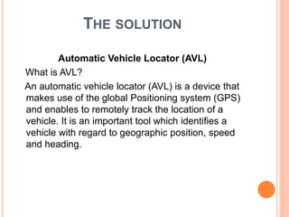
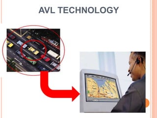
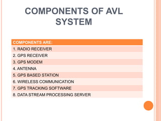
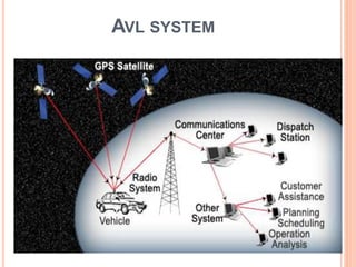
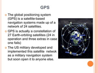
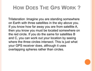
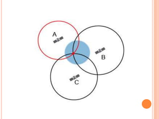
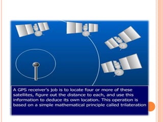
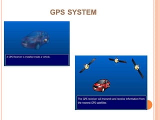
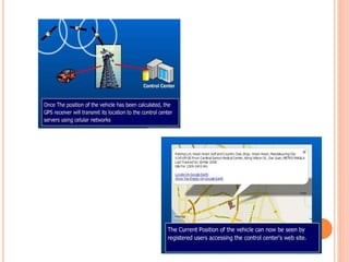
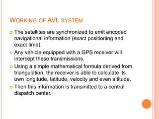
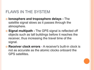
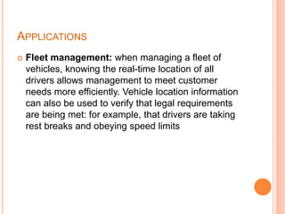
AUTOMATIC VEHICLE
LOCATOR
Presented by:-
KUSHAGRA KRISHNA
10300512036
(12-EI-36)
A FEW QUESTIONS
 Is your car or vehicle stolen and is not visible
among the several cars present?
 Do you want to know the arrival for the bus you are
waiting?
 Are you going alone in your vehicle and your
parents want to track you movements because they
are worried about you?
 Does your cargo consists of costly loads and you
want to protect them?
THE SOLUTION
Automatic Vehicle Locator (AVL)
What is AVL?
An automatic vehicle locator (AVL) is a device that
makes use of the global Positioning system (GPS)
and enables to remotely track the location of a
vehicle. It is an important tool which identifies a
vehicle with regard to geographic position, speed
and heading.
AVL TECHNOLOGY
COMPONENTS OF AVL
SYSTEM
COMPONENTS ARE:
1. RADIO RECEIVER
2. GPS RECEIVER
3. GPS MODEM
4. ANTENNA
5. GPS BASED STATION
6. WIRELESS COMMUNICATION
7. GPS TRACKING SOFTWARE
8. DATA STREAM PROCESSING SERVER
AVL SYSTEM
GPS
 The global positioning system
(GPS) is a satellite-based
navigation systems made up of a
network of 24 satellites.
 GPS is actually a constellation of
27 Earth-orbiting satellites (24 in
operation and three extras in case
one fails)
 The US military developed and
implemented this satellite netwok
as a military navigation system
but soon open it to anyone else.
HOW DOES THE GPS WORK ?
Trilateration :Imagine you are standing somewhere
on Earth with three satellites in the sky above you.
If you know how far away you are from satellite A,
then you know you must be located somewhere on
the red circle. If you do the same for satellites B
and C, you can work out your location by seeing
where the three circles intersect. This is just what
your GPS receiver does, although it uses
overlapping spheres rather than circles.
COMPONENTS
 Radio receiver : A radio receiver is an electronic
device that receives radio waves and converts the
information carried by them to a usable form. It is
used with an antenna
 GPS receiver : A GPS receiver's job is to locate four
or more of these satellites, figure out the distance to
each, and use this information to deduce its own
location.
 GPS modem : A GSM modem is used to send the
position of the vehicle from a remote place.
 Antenna: An antenna (or aerial) is an electrical
device which converts electric power into radio
waves, and vice versa.
 Base station : In a comp. network it is a transceiver
acting as a router for computers in the network,
possibly connecting them to a local area
network and/or the internet.
 Wireless communication : Wireless
communication is the transfer of
information between two or more points that are not
connected by an electrical conductor.
 GPS tracking : A GPS tracking unit is a device that
uses the Global Positioning System to determine
the precise location of a vehicle, person, or other
asset to which it is attached and to record the
position of the asset at regular intervals.
 Processing : The goal of complex event processing
is to identify meaningful events (such
as threats)and respond to them as quickly as
possible.
WORKING OF AVL SYSTEM
 The satellites are synchronized to emit encoded
navigational information (exact positioning and
exact time).
 Any vehicle equipped with a GPS receiver will
intercept these transmissions.
 Using a simple mathematical formula derived from
triangulation, the receiver is able to calculate its
own longitude, latitude, velocity and even altitude.
 Then this information is transmitted to a central
dispatch center.
MAPPING
 Maps allow understandable view of vehicles
location and will also allow operators to apply local
knowledge.
FLAWS IN THE SYSTEM
 Ionosphere and troposphere delays - The
satellite signal slows as it passes through the
atmosphere.
 Signal multipath - The GPS signal is reflected off
objects such as tall buildings before it reaches the
receiver, thus increasing the travel time of the
signal.
 Receiver clock errors - A receiver's built-in clock is
not as accurate as the atomic clocks onboard the
GPS satellites.
APPLICATIONS
 Fleet management: when managing a fleet of
vehicles, knowing the real-time location of all
drivers allows management to meet customer
needs more efficiently. Vehicle location information
can also be used to verify that legal requirements
are being met: for example, that drivers are taking
rest breaks and obeying speed limits
• Passenger Information: Real-time Passenger
information systems use predictions based on AVL
input to show the expected arrival and departure
times of Public Transport services.
• Asset tracking : companies needing to track
valuable assets for insurance or other monitoring
purposes can now plot the real-time asset location
on a map and closely monitor movement and
operating status.
• Field worker management: companies with a
field service or sales workforce can use information
from vehicle tracking systems to plan field workers'
time, schedule subsequent customer visits and be
able to operate these departments efficiently.
• Covert surveillance: vehicle location devices
attached covertly by law enforcement or espionage
organizations can be used to track journeys made
by individuals who are under surveillance
CONCLUSION
The future prospects of GPS technology
are virtually limitless
Today’s GPS receivers are extremely
accurate. They provide a worst accuracy of
20 meters.
THANK YOU

Automatic Vehicle Locator

  • 1.
  • 2.
    A FEW QUESTIONS Is your car or vehicle stolen and is not visible among the several cars present?  Do you want to know the arrival for the bus you are waiting?  Are you going alone in your vehicle and your parents want to track you movements because they are worried about you?  Does your cargo consists of costly loads and you want to protect them?
  • 3.
    THE SOLUTION Automatic VehicleLocator (AVL) What is AVL? An automatic vehicle locator (AVL) is a device that makes use of the global Positioning system (GPS) and enables to remotely track the location of a vehicle. It is an important tool which identifies a vehicle with regard to geographic position, speed and heading.
  • 4.
  • 5.
    COMPONENTS OF AVL SYSTEM COMPONENTSARE: 1. RADIO RECEIVER 2. GPS RECEIVER 3. GPS MODEM 4. ANTENNA 5. GPS BASED STATION 6. WIRELESS COMMUNICATION 7. GPS TRACKING SOFTWARE 8. DATA STREAM PROCESSING SERVER
  • 6.
  • 7.
    GPS  The globalpositioning system (GPS) is a satellite-based navigation systems made up of a network of 24 satellites.  GPS is actually a constellation of 27 Earth-orbiting satellites (24 in operation and three extras in case one fails)  The US military developed and implemented this satellite netwok as a military navigation system but soon open it to anyone else.
  • 8.
    HOW DOES THEGPS WORK ? Trilateration :Imagine you are standing somewhere on Earth with three satellites in the sky above you. If you know how far away you are from satellite A, then you know you must be located somewhere on the red circle. If you do the same for satellites B and C, you can work out your location by seeing where the three circles intersect. This is just what your GPS receiver does, although it uses overlapping spheres rather than circles.
  • 13.
    COMPONENTS  Radio receiver: A radio receiver is an electronic device that receives radio waves and converts the information carried by them to a usable form. It is used with an antenna  GPS receiver : A GPS receiver's job is to locate four or more of these satellites, figure out the distance to each, and use this information to deduce its own location.  GPS modem : A GSM modem is used to send the position of the vehicle from a remote place.
  • 14.
     Antenna: Anantenna (or aerial) is an electrical device which converts electric power into radio waves, and vice versa.  Base station : In a comp. network it is a transceiver acting as a router for computers in the network, possibly connecting them to a local area network and/or the internet.  Wireless communication : Wireless communication is the transfer of information between two or more points that are not connected by an electrical conductor.
  • 15.
     GPS tracking: A GPS tracking unit is a device that uses the Global Positioning System to determine the precise location of a vehicle, person, or other asset to which it is attached and to record the position of the asset at regular intervals.  Processing : The goal of complex event processing is to identify meaningful events (such as threats)and respond to them as quickly as possible.
  • 17.
    WORKING OF AVLSYSTEM  The satellites are synchronized to emit encoded navigational information (exact positioning and exact time).  Any vehicle equipped with a GPS receiver will intercept these transmissions.  Using a simple mathematical formula derived from triangulation, the receiver is able to calculate its own longitude, latitude, velocity and even altitude.  Then this information is transmitted to a central dispatch center.
  • 18.
    MAPPING  Maps allowunderstandable view of vehicles location and will also allow operators to apply local knowledge.
  • 20.
    FLAWS IN THESYSTEM  Ionosphere and troposphere delays - The satellite signal slows as it passes through the atmosphere.  Signal multipath - The GPS signal is reflected off objects such as tall buildings before it reaches the receiver, thus increasing the travel time of the signal.  Receiver clock errors - A receiver's built-in clock is not as accurate as the atomic clocks onboard the GPS satellites.
  • 21.
    APPLICATIONS  Fleet management:when managing a fleet of vehicles, knowing the real-time location of all drivers allows management to meet customer needs more efficiently. Vehicle location information can also be used to verify that legal requirements are being met: for example, that drivers are taking rest breaks and obeying speed limits
  • 22.
    • Passenger Information:Real-time Passenger information systems use predictions based on AVL input to show the expected arrival and departure times of Public Transport services. • Asset tracking : companies needing to track valuable assets for insurance or other monitoring purposes can now plot the real-time asset location on a map and closely monitor movement and operating status.
  • 23.
    • Field workermanagement: companies with a field service or sales workforce can use information from vehicle tracking systems to plan field workers' time, schedule subsequent customer visits and be able to operate these departments efficiently. • Covert surveillance: vehicle location devices attached covertly by law enforcement or espionage organizations can be used to track journeys made by individuals who are under surveillance
  • 24.
    CONCLUSION The future prospectsof GPS technology are virtually limitless Today’s GPS receivers are extremely accurate. They provide a worst accuracy of 20 meters.
  • 25.