Downloaded 31 times

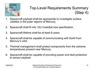
![Mission Timeline (Step 3)
Phase End Defined By Duration
Typical Duration *
(Small Program)
Concept Exploration
Start of tech. funding; preliminary
requirements release 3 months 1-6 months
Detailed Development
Risk Reduction/Technology
Development Start of program funding 3 - 6 months 0 - 12 months
Detailed Design and
Development Formal requirements release 6 months 2 - 12 months
Production and Deployment
Production Ship to Launch Site 6 months 6 - 24 months
Launch Lift-Off and Arrival in LEO 1 month 1 month
On-Orbit Checkout/Transfer
to Operational Orbit Start of operations 6 years
Up to 10 years
interplanetary
Operations and Support
Operations
Spacecraft dies or decision to be
put to sleep 1+ years 1 month - 5 years
Disposal Re-entry or turn-off 0 years 0 - 5 years
4/9/2016
Applying Systems Engineering Process to
a Conceptual Mercury CubeSat Mission
10
* Typical Durations come from SME-SMAD [11, Table 3-3, Page 54]](https://image.slidesharecdn.com/kgrothe-rmc2016-mercurycubesat-170522225756/85/Applying-the-Systems-Engineering-Process-to-a-Conceptual-Merucry-CubeSat-Mission-10-320.jpg)
![References
• [1] Committee on the Planetary Science Decadel Survey, Voyages and Vision for Planetary Science in the Decade
2013 - 2022, Washington D.C.: National Academies Press, 2011.
• [2] S. Squyres, "Vision and Voyages for Planetary Science in the Decade 2013-2022, Rollout at LPSC," 11 March
2010. [Online]. Available: http://solarsystem.nasa.gov/docs/Squyres_2013_Decadal_Rollout_at_LPSC.pdf .
[Accessed 4 May 2015].
• [3] The CubeSat Program, , "CubeSat Design Specification Rev 13, Final2, PDF File," 6 April 2015. [Online].
Available: http://cubesat.org/images/developers/cds_rev13_final2.pdf . [Accessed 4 May 2015].
• [4] The Planetary Society, "NASA's Planetary Science Division Funding and Number of Missions 2004 - 2020," 9
February 2015. [Online]. Available: http://www.planetary.org/multimedia/space-images/charts/historical-levels-of-
planetary-exploration-funding-fy2003-fy2019.html . [Accessed 6 May 2015].
• [5] Solar System Exploration Research Virtual Institute (SSERVI), "Lunar Flashlight," NASA, [Online]. Available:
http://sservi.nasa.gov/articles/lunar-flashlight/ . [Accessed 6 May 2015].
• [6] P. Banazadeh and A. Frick, “Lunar Flashlight and NEA Scout: A NanoSat Architecture for Deep Space
Exploration," 2014. [Online]. Available: http://www.intersmallsatconference.com/ . [Accessed 6 May 2015].
• [7] R. Staehle and e. al., “Lunar Flashlight: Finding Lunar Volatiles Using CubeSats," 13 November 2013. [Online].
Available: http://sservi.nasa.gov/wp-content/uploads/2014/04/Staehle-presentation-Lunar-Flashlight-20131109.pdf
. [Accessed 6 May 2015].
• [8] Michael Swartwout, PhD, Associate Professor, Aerospace and Mechanical Engineering, Saint Louis University,
CubeSat Database. [Online]. Available: https://sites.google.com/a/slu.edu/swartwout/home/cubesat-database
• [9] NASA, “NASA Technology Roadmaps, TA 2: In-Space Propulsion Technologies”, May 2015 Draft. [Online.]
Available at:
http://www.nasa.gov/sites/default/files/atoms/files/2015_nasa_technology_roadmaps_ta_2_in_space_propulsion.p
df [Accessed 12 October 2015]
4/9/2016 Applying Systems Engineering Process to
a Conceptual Mercury CubeSat Mission
31](https://image.slidesharecdn.com/kgrothe-rmc2016-mercurycubesat-170522225756/85/Applying-the-Systems-Engineering-Process-to-a-Conceptual-Merucry-CubeSat-Mission-31-320.jpg)
![References
• [10] NASA, “Definition of Technology Readiness Levels.” [Online]. Available at: http://esto.nasa.gov/files/trl_definitions.pdf
[Accessed 12 October 2015]
• [11] J. Wertz, D. Everett and J. Puschell, Space Mission Engineering: The New SMAD. Hawthorne, CA: Microcosm Press,
2011.
• [12] C. Gustafson and S. Janson, 'Think Big, Fly Small', Crosslink, 2014.
• [13] NASA Ames Research Center, 'Small Spacecraft Technology State of the Art', NASA Center for AeroSpace Information,
2014.
• [14] Canisterized Satellite Dispenser (CSD) Data Sheet, 1st ed. Planetary Systems Corporation, 2015. [Online]. Available at:
http://www.planetarysystemscorp.com/web/wp-content/uploads/2015/08/2002337C-CSD-Data-Sheet.pdf [Accessed 31
October 2015]
• [15] W. Holemans, 'Lunar Water Distribution (LWaDi)-- a 6U Lunar Orbiting spacecraft SSC14-WK-22', 11th Annual
Summer CubeSat Developers' Workshop, 2014. [Online]. Available at: http://www.planetarysystemscorp.com/web/wp-
content/uploads/2014/09/Lunar-Water-Distribution-LWaDi-a-6U-Lunar-Orbiting-spacecraft.pdf [Accessed 31 October 2015]
• [16] J. Sheehan, 'PEPL: Thrusters: CubeSat Ambipolar Thruster', Plasmadynamics and Electric Propulsion Laboratory,
University of Michigan, 2015. [Online]. Available: http://pepl.engin.umich.edu/thrusters/CAT.html [Accessed: 01- Nov- 2015].
• [17] Aerojet Rocketdyne, 'MPS-160™ Solar Electric Power / Solar Electric Propulsion System', 2015. [Online]. Available:
http://www.rocket.com/cubesat/mps-160 [Accessed: 01- Nov- 2015].
• [18] Propulsion Unit for CubeSats (PUC), 1st ed. VACCO Industries, 2015. [Online]. Available:
http://www.vacco.com/images/uploads/pdfs/11044000-01_PUC.pdf [Accessed: 01- Nov- 2015].
• [19] ARTEMIS Space, 'ARTEMIS Lunar Constellation', 2014. [Online]. Available: http://www.artemis-space.com/artemis-
lunar-constellation/ [Accessed: 01- Nov- 2015].
• [20] P. Dyches, 'JPL Selects Europa CubeSat Proposals for Study', NASA JPL News, 2014. [Online]. Available:
http://www.jpl.nasa.gov/news/news.php?feature=4330 [Accessed: 01- Nov- 2015].
4/9/2016 Applying Systems Engineering Process to
a Conceptual Mercury CubeSat Mission
32](https://image.slidesharecdn.com/kgrothe-rmc2016-mercurycubesat-170522225756/85/Applying-the-Systems-Engineering-Process-to-a-Conceptual-Merucry-CubeSat-Mission-32-320.jpg)
![References
• [21] D. Spence, E. Ehrbar, N. Rosenblad, N. Demmons, T. Roy, S. Hoffman, D. Williams, V. Hruby and C.
Tocci, Electrospray Propulsion Systems for Small Satellites, 1st ed. Busek Co., Inc., 2013. [Online]. Available:
http://digitalcommons.usu.edu/cgi/viewcontent.cgi?filename=0&article=2960&context=smallsat&type=additional
[Accessed: 01- Nov- 2015].
• [22] Busek 100uN-Class Electrospray Thrusters, 1st ed. Busek Co., Inc., 2015. [Online]. Available:
http://www.busek.com/index_htm_files/70008516E.pdf [Accessed: 01- Nov- 2015].
• [23] HYDROS Thruster, 1st ed. Bothell, WA: Tethers Unlimited, Inc., 2015. [Online]. Available:
http://www.tethers.com/SpecSheets/Brochure_HYDROS.pdf [Accessed: 01- Nov- 2015].
• [24] L. Johnson, Solar Sail Propulsion for Interplanetary Small Spacecraft, 1st ed. NASA, 2015. [Online]. Available:
http://images.spaceref.com/fiso/2015/032515_les_johnson_nasa_msfc/Johnson_3-25-15.pdf [Accessed: 01- Nov-
2015].
• [25] J. Fleurial, Thermoelectrics in Space: A Success Story, What’s Next and What Might Be Possible, 1st ed.
Pasadena, CA: JPL, 2015. [Online]. Available:
http://www.kiss.caltech.edu/study/adaptiveII/Kiss%202015%20Workshop%20JPF%20TE%20Brief%20rev1.pdf
[Accessed: 01- Nov- 2015].
• [26] B. Cohen, 'Lunar Flashlight and Near Earth Asteroid Scout: Exploration Science Using Cubesats', 2nd NASA
Exploration Science Forum; Moffett Field, CA, 2015. [Online]. Available:
http://ntrs.nasa.gov/archive/nasa/casi.ntrs.nasa.gov/20150015511.pdf [Accessed: 01- Nov- 2015].
• [27] R. Hodges, 'ISARA: Integrated Solar Array Reflectarray Mission Overview', CubeSat Developers Workshop at
the Small Satellite Conference, 2013. [Online]. Available:
http://digitalcommons.usu.edu/cgi/viewcontent.cgi?filename=0&article=2877&context=smallsat&type=additional
[Accessed: 01- Nov- 2015].
4/9/2016 Applying Systems Engineering Process to
a Conceptual Mercury CubeSat Mission
33](https://image.slidesharecdn.com/kgrothe-rmc2016-mercurycubesat-170522225756/85/Applying-the-Systems-Engineering-Process-to-a-Conceptual-Merucry-CubeSat-Mission-33-320.jpg)
![References
• [28] M. Aherne, J. Barrett, L. Hoag, E. Teegarden and R. Ramadas, Aeneas -- Colony I Meets Three-Axis
Pointing, 1st ed. Marina del Rey, CA: Space Engineering Research Center, 2011. [Online]. Available:
http://digitalcommons.usu.edu/cgi/viewcontent.cgi?article=1181&context=smallsat [Accessed: 01- Nov- 2015].
• [29] Messenger.jhuapl.edu, 'MESSENGER: MErcury Surface, Space ENvironment, GEochemistry, and
Ranging - Thermal Design', 2015. [Online]. Available: http://messenger.jhuapl.edu/spacecraft/thermal.html
[Accessed: 01- Nov- 2015].
• [30] Messenger.jhuapl.edu, 'MESSENGER: MErcury Surface, Space ENvironment, GEochemistry, and
Ranging - Power', 2015. [Online]. Available: http://messenger.jhuapl.edu/spacecraft/power.html [Accessed:
01- Nov- 2015].
• [31] Messenger.jhuapl.edu, 'MESSENGER: MErcury Surface, Space ENvironment, GEochemistry, and
Ranging - Mission Design', 2015. [Online]. Available:
http://messenger.jhuapl.edu/the_mission/mission_design.html [Accessed: 01- Nov- 2015].
• [32] Messenger.jhuapl.edu, 'MESSENGER: MErcury Surface, Space ENvironment, GEochemistry, and
Ranging - The Payload Instruments', 2015. [Online]. Available:
http://messenger.jhuapl.edu/instruments/index.html [Accessed: 01- Nov- 2015].
• [33] Messenger.jhuapl.edu, 'MESSENGER: MErcury Surface, Space ENvironment, GEochemistry, and
Ranging - Working from Orbit', 2015. [Online]. Available: http://messenger.jhuapl.edu/the_mission/orbit.html
[Accessed: 01- Nov- 2015].
4/9/2016 Applying Systems Engineering Process to
a Conceptual Mercury CubeSat Mission
34](https://image.slidesharecdn.com/kgrothe-rmc2016-mercurycubesat-170522225756/85/Applying-the-Systems-Engineering-Process-to-a-Conceptual-Merucry-CubeSat-Mission-34-320.jpg)

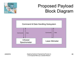
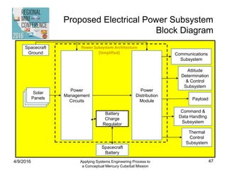
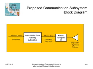
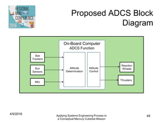
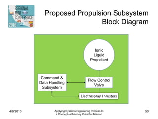
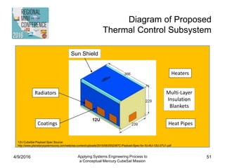

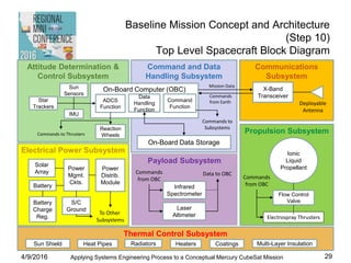
The document outlines a proposal for a conceptual interplanetary cubesat mission to Mercury, using a systems engineering approach to address mission objectives, design considerations, and requirements. The primary objective is to investigate surface volatiles at Mercury's poles while utilizing a less expensive spacecraft to enhance timely scientific exploration. Detailed topics include stakeholder involvement, mission architecture, timelines, risk mitigation strategies, and performance assessments for propulsion and communication systems.