Downloaded 10 times
![Going for GOLD – Adventures in Open Linked Metadata
James Reid, Business Development and Projects Manager , EDINA, University of
Edinburgh; Will Waites, University of Edinburgh; Ben Butchart, Senior Software
Engineer, EDINA, University of Edinburgh;
Introduction
EDINA1 as a JISC2 national data centre makes available, inter alia many geographical datasets and
services for use by the UK academic community. To support discovery of these resources it
operates metadata catalogues that one can search and browse to find specific items of interest.
These metadata are typically made available both in HTML form for human consumption and in a
machine readable form, often as ISO XML for compliance with international obligations.
Catalogue systems which publish geospatial metadata (that is, information held in structured
records that describe the characteristics of data and services), and which provide interfaces for
their query and maintenance have been promoted by the Open Geospatial Consortia 3 (OGC) for
some time. The Catalogue Services (CS) specification which provides just such a standard method
of defining, querying and organising stores of geospatial metadata (Nebert et al. 2007) is the de
facto standard for discovering information about geospatial data and services in a standards
compliant fashion. The CS specification defines an HTTP protocol binding named Catalogue
Services for the Web (CSW) which underpins resource discovery across and within Spatial Data
Infrastructures (SDIs) such as the UK Location Information Infrastructure. The UK academic
sector has its own thematic SDI and already has its own geospatial discovery service through
GoGeo4.
Independent of this, there is a growing trend to make such metadata catalogues available in a
uniform way using techniques from Linked Data 5 and the semantic web. Reasons for this include
the ability to correlate metadata across different catalogue implementations that may use very
different internal representations, to facilitate linking and annotation of the metadata by third
parties and to provide a basic level of referential infrastructure on top of which more difficult
questions of provenance and quality can be addressed.
Context
An example of the broader relevance of CSW and geospatial metadata for discovery purposes, is
the recommendation issued in the context of INSPIRE 6 by the INSPIRE Network Services Drafting
Team (2008) to SDIs in the European Union to derive the base functionality of discovery services
from the ISO profile of CSW. However, CSW is, arguably, not ideally suited for the modern Web
where search engines are the users’ default gateway to information 7. The reasons why CSW might
1
edina.ac.uk
2
www.jisc.ac.uk
3
www.opengeospatial.org
4
www.gogeo.ac.uk
5
linkeddata.org/
6
INSPIRE defines the legislative framework for the establishment of a pan-European geospatial resource infrastructure.
One of its key aims is to improve the 'discoverability' of geospatial resources by publication of resource metadata.
7
Several studies of research behaviour in the UK HFE sector support the view that 'googling' is a default reflex when
seeking out resources. As noted by in 'Information behaviour of the researcher of the future', UCL, 2008, “they [resource
providers] need to make their sites more highly visible in cyberspace by opening them up to search engines”
AGI GeoCommunity '11: Placing Ourselves in the New Economy](https://image.slidesharecdn.com/agi11paper-gold-111012034434-phpapp01/85/Going-for-GOLD-Adventures-in-Open-Linked-Metadata-1-320.jpg)

![established. For describing data catalogues there is a specific vocabulary which is specifically
designed to augment DC called the Data Catalog Vocabulary or DCat. Of particular interest are the
concepts of dcat:Catalog, dcat:CatalogRecord and dcat:Distribution. Also used is dcat:Dataset
which is simply an alias for dc:Dataset.
Further predicates are used for expressing other metadata such as keywords and spatio-temporal
granularity. For referring to people, either natural or corporate, common practice is to use the
Friend-of-a-Friend or FOAF vocabulary18. Where the precise nature of the entity in question is
unclear foaf:Agent19 was used. Where it is clear that a natural person is being referred to, the
more specific foaf:Person was used and if it was an organisation we used foaf:Organisation. For
more involved descriptions of people and organisations and their relationship, the Organisation
Ontology[?] may be used. This vocabulary provides facilities for describing the role that a
particular person may fill in an organisation, for example.
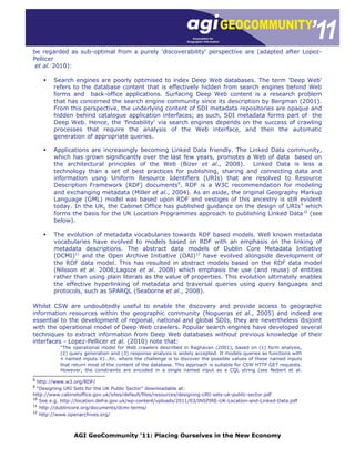
Before addressing questions of how to represent spatial data, (which are far from settled),
consider the fictitious example catalogue in Figure 1.
@prefix ex: <http://example.org/>
ex:catalogue a dcat:Catalog;
dc:description "An example catalogue";
dcat:keyword "Examples";
dc:record ex:rec1, ex:rec2, ex:rec3.
ex:org a foaf:Organisation;
foaf:name "Ficticious Inc.";
foaf:mbox <mailto:someone@example.org>.
ex:sa a foaf:Organisation;
foaf:name "Space Agency of Somewheria".
ex:rec1 a dcat:CatalogRecord;
dc:modified "2011-07-01"^^xsd:date;
dc:maintainer ex:org;
dcat:dataset [
a dcat:Dataset;
dc:identifier "ABCD-EF12-3456-7890-DCBA";
dc:modified "1984-03-23"^^xsd:date;
dc:contributor ex:sa;
dc:title "Pictures of crop circles from space";
dcat:distribution [
a dcat:Distribution;
dc:description "Shape file download of crop circles";
dcat:accessURL <http://download.example.org/crops.shp>
], [
a dcat:Distribution;
]
].
ex:rec2 a dcat:CatalogRecord;
...
ex:rec3 a dcat:CatalogRecord;
Figure 1. An example catalogue
This example is not intended to be a complete representation of all the metadata that may be
contained in such a catalogue but is intended to give a clearer idea of the structure. The
distinction between the description of a catalogue record and the description of the dataset itself
may seem pedantic but is in fact quite important. Frequently, the metadata record may be
changed or updated in isolation, even when no change to the dataset itself has been made. The
dataset may be maintained by one person or organisation and this person may have no influence
whatsoever over the metadata catalogue. Separating out the concepts is important in order to be
able to express this difference. This separation is well known and is already expressed through
18
http://xmlns.com/foaf/spec/
19
a subclass of dc:Agent
AGI GeoCommunity '11: Placing Ourselves in the New Economy](https://image.slidesharecdn.com/agi11paper-gold-111012034434-phpapp01/85/Going-for-GOLD-Adventures-in-Open-Linked-Metadata-5-320.jpg)

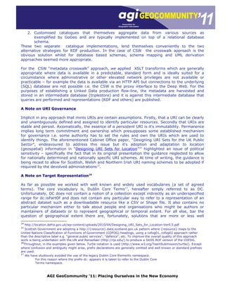
![say which approach represents the 'best' for future proofing purposes and consequently we have
applied a 'best guess' logic. Considering the example in Figure 2, though we have used the WKT
as the lowest common denominator representation of geospatial data, there is room alongside for
other equivalent representations in e.g. GML as the Ordnance Survey does - or indeed, in
expressly materialised granular RDF as with NeoGeo. Yet it also retains the properties of being
easy to display to users using common tools and easy to index when importing into an RDF
database.
[
a dcat:Dataset;
dc:spatial [
a geo:Geometry;
geo:asWKT "<http://www.opengis.net/def/crs/ogc/1.3/CRS84>
POLYGON((12.9709 52.3005, 12.9709 52.6954,
13.8109 52.6954, 13.8109 52.3005))"^^geo:WKTLiteral
]
].
Figure 2. Geographical metadata example.
Metadata Crosswalk
In some sense any transformation technique could be called a “metadata crosswalk”. The specific
meaning here is a transformation that is done on a particular document (in this case a catalogue
record) rather than at the level of a database or collection of such documents. The approach turns
on a 'harvesting' mechanism similar to that used more generally across the European spatial data
infrastructure and elsewhere. Algorithm 1 is executed periodically against a data source.
procedure Harvest(source, start)
for xml in source modified since start do
rdf ← Transform(xml)
Store(rdf )
end for
end procedure
Algorithm 1. Harvesting algorithm
Retrieved documents are transformed using an XSLT transform and are then stored in an RDF
database24. For this project a specialised CSW client was written and this implements the query
and actual fetching of ISO19139 documents from a server such as Geonetwork 25 (which is used in
national and thematic based catalogues in the UK).
The storage step is also important in that it must extract from the intermediary RDF data a
suitable graph name, a URI that will be used to both identify a catalogue record and to group the
statements that belong in this record. It is clear from Figure 1 that, because a catalogue record is
“several levels deep” it is not sufficient to just, say, consider all statements with a given subject in
order to obtain a complete catalogue record. In order to save on the expense of complex queries,
the data relating to a particular record is therefore grouped together into a named graph during
harvesting. This also simplifies updating records that have changed since it is merely necessary to
replace the entire graph rather than do complex queries to determine exactly which statements
need to be retracted before any new ones are added.
The bulk of the logic, however, is done by the transformation step. In this case it uses an XSLT
stylesheet26 to transform ISO19139 XML data into RDF/XML which may then be stored. The
24
In our case using 4Store (http://4store.org/)
25
http://geonetwork-opensource.org/
26
The current version of this stylesheet is available at https://bitbucket.org/ww/
gold/src/tip/static/csw/md_metadata.xsl
AGI GeoCommunity '11: Placing Ourselves in the New Economy](https://image.slidesharecdn.com/agi11paper-gold-111012034434-phpapp01/85/Going-for-GOLD-Adventures-in-Open-Linked-Metadata-7-320.jpg)


![and frequently used vocabularies e.g. FOAF, DCat. An open question remains as to whether or not
Linked Data is the panacea to resource discovery and reuse that its proponents assert. A
significant issue to overcome is to establish core, common vocabularies – particularly in respect
to alternate and competing approaches to the representation of geometry information.
References
Bergman, Michael K. (2001) White Paper: The Deep Web: Surfacing Hidden Value, The Journal of
Electronic Publishing (JEP), Volume 7, Issue 1, August, 2001. Available from:
http://hdl.handle.net/2027/spo.3336451.0007.104
Bizer, C.; Heath, T.; Idehen, K. and Berners-Lee, T. (2008) Linked data on the web (LDOW2008)
WWW '08: Proceeding of the 17th international conference on World Wide Web, ACM, 1265-1266
Fielding, R. T. (2000) REST: Architectural Styles and the Design of Network based Software
Architectures University of California, Irvine
Goodwin, J.; Dolbear, C. and Hart, G. (2009) Geographical Linked Data: The Administrative
Geography of Great Britain on the Semantic Web Transactions in GIS, doi: 10.1111/j.1467-
9671.2008.01133.x
Lagoze, C. and de Sompel, H. V. (2008) ORE User Guide – Resource Map Implementation in
RDF/XML Open Archives Initiative. Available from: http://www.openarchives.org/ore/1.0/rdfxml
Lopez-Pellicer F. J., Florczyk A. J., Nogueras-Iso J, Muro-Medrano P. R. and Zarazaga-Soria F. J.
(2010) Exposing CSW catalogues as Linked Data, Lecture Notes in Geoinformation and Cartography
(LNG&C). Geospatial Thinking. 2010, vol. , p. 183-200. ISSN 1863-2246
Madhavan, J., Ko, D., Kot, L., Ganapathy, V., Rasmussen, A. and Halevy, A. (2008) Google's Deep
Web crawl, Proceedings of the VLDB Endowment, VLDB Endowment, 1, 1241-1252
Miller, E. and Manola, F. (2004) RDF Primer. W3C, Available from http://www.w3.org/TR/2004/REC-
rdf-primer-20040210/
Nebert, D., Whiteside, A. and Vretanos, P. A. (2007). Open GIS Catalogue Services Specification.
OpenGIS Publicy Available Standard, Open GIS Consortium Inc.
Nilsson, M.; Powell, A.; Johnston, P. and Naeve, A. (2008) Expressing Dublin Core metadata using
the Resource Description Framework (RDF) [online] Dublin Core Metadata Initiative, DCM
Nogueras-Iso, J., Zarazaga-Soria, F.J., Muro-Medrano, P.R. (2005) Geographic Information Metadata
for Spatial Data Infrastructures: Resources, Interoperability and Information Retrieval. Springer-
Verlag New York, Inc., Secaucus, NJ, USA
Raghavan, S. and Garcia-Molina, H. (2001) Crawling the Hidden Web VLDB '01:Proceedings of the
27th International Conference on Very Large Data Bases, Morgan Kaufmann Publishers Inc., 129-138
Seaborne, A. & Prud'hommeaux, E. (2008) SPARQL Query Language for RDF W3C.
W3CRecommendation. Available from:http://www.w3.org/TR/2008/REC-rdf-sparql-query-20080115/
Turner, A. (2006) Introduction to neogeography O'Reilly Media, Inc.
Vretanos, P. A. (2004) OpenGIS Filter Encoding Implementation Specification Open Geospatial
Consortium Inc.
AGI GeoCommunity '11: Placing Ourselves in the New Economy](https://image.slidesharecdn.com/agi11paper-gold-111012034434-phpapp01/85/Going-for-GOLD-Adventures-in-Open-Linked-Metadata-12-320.jpg)

The document discusses the challenges and developments in geospatial metadata management, particularly concerning the necessity of making such data discoverable through modern web practices. It highlights the shortcomings of existing standards like Catalogue Services for the Web (CSW) when it comes to search engine optimization and user accessibility, advocating for the use of linked data principles to facilitate better integration and interoperability. The authors propose strategies for transforming existing metadata into RDF formats to enhance discoverability and usability while addressing governance and representation issues within the UK geospatial context.


![[Databeers] 06/05/2014 - Boris Villazon: “Data Integration - A Linked Data ap...](https://cdn.slidesharecdn.com/ss_thumbnails/ld-databeers-140508020333-phpapp02-thumbnail.jpg?width=640&height=640&fit=bounds)