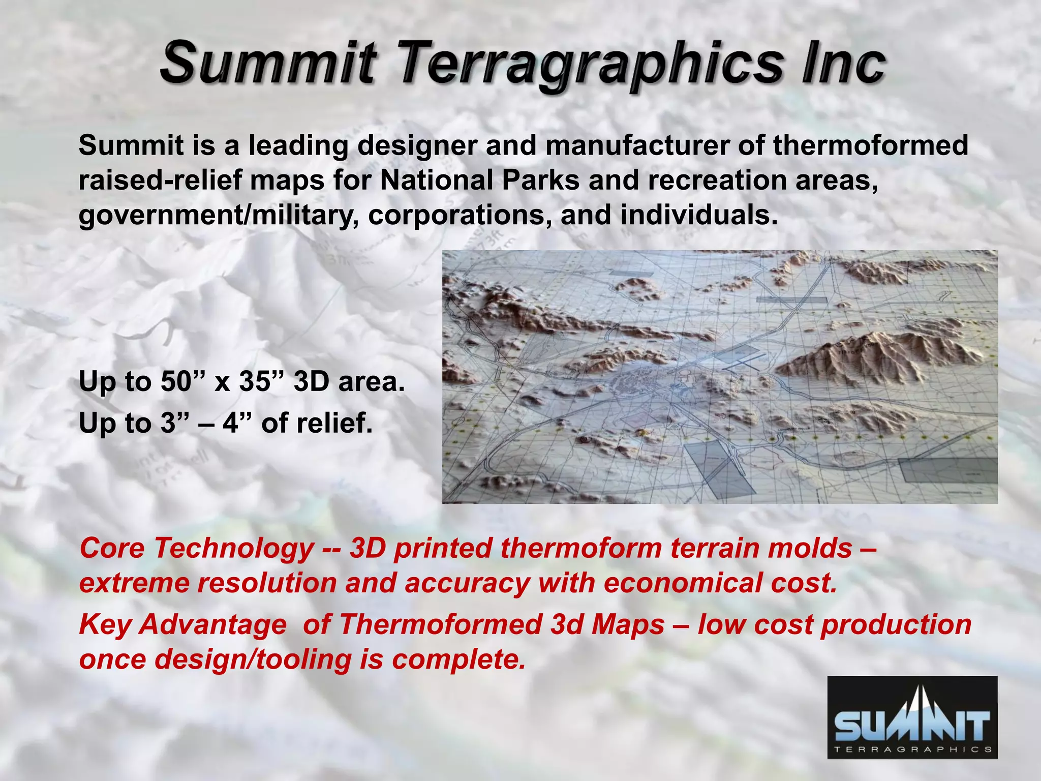
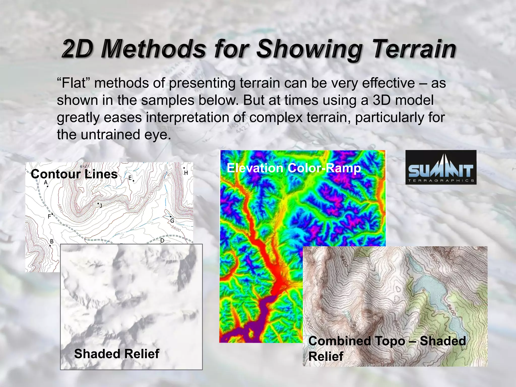
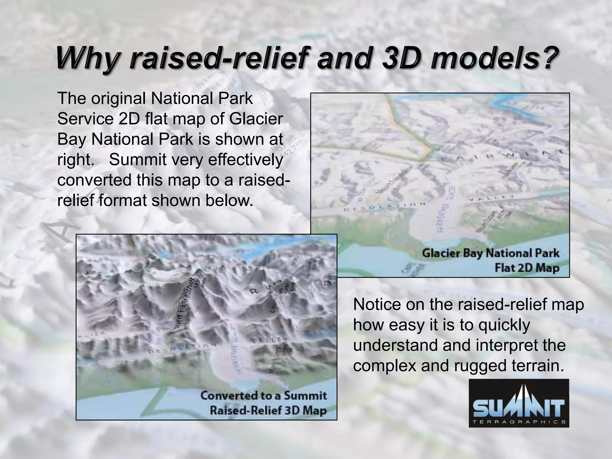
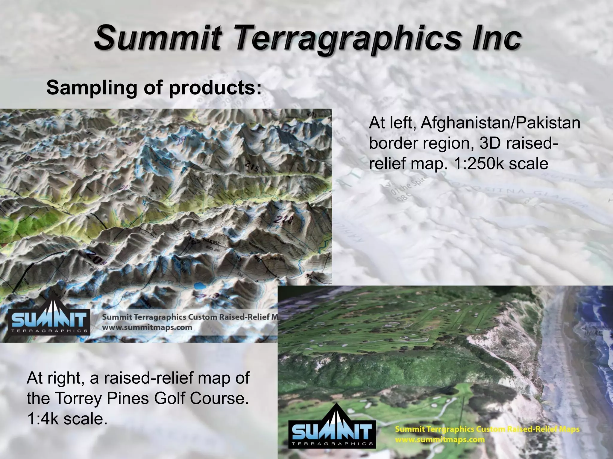
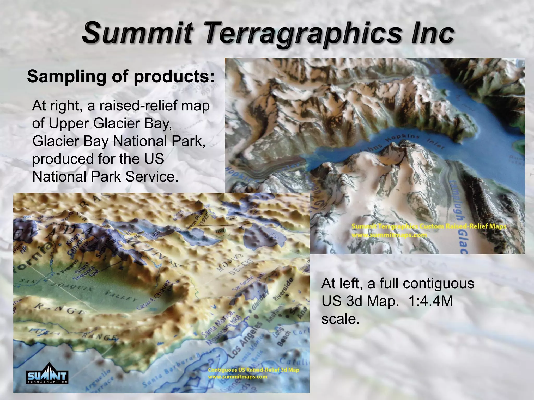
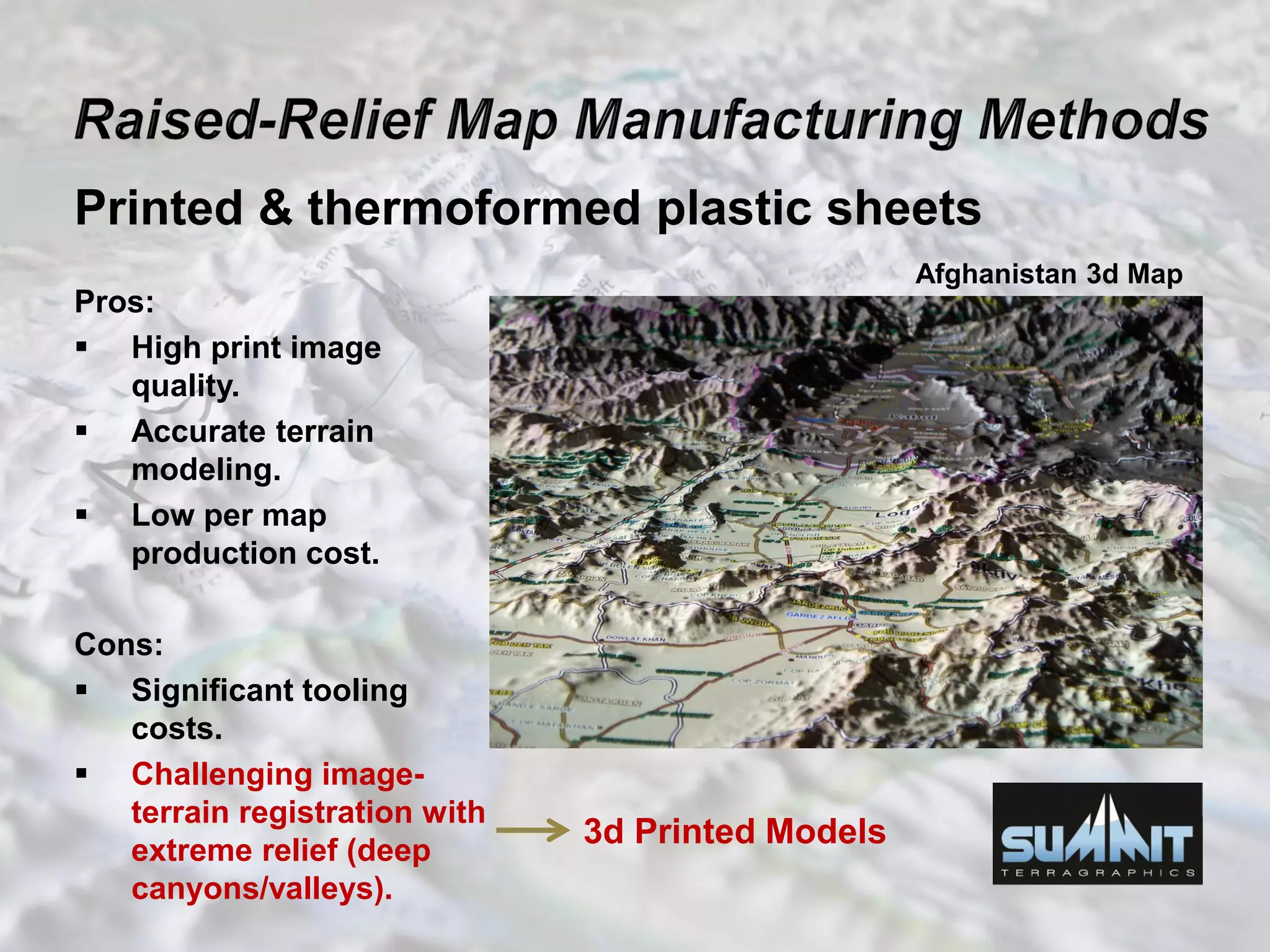
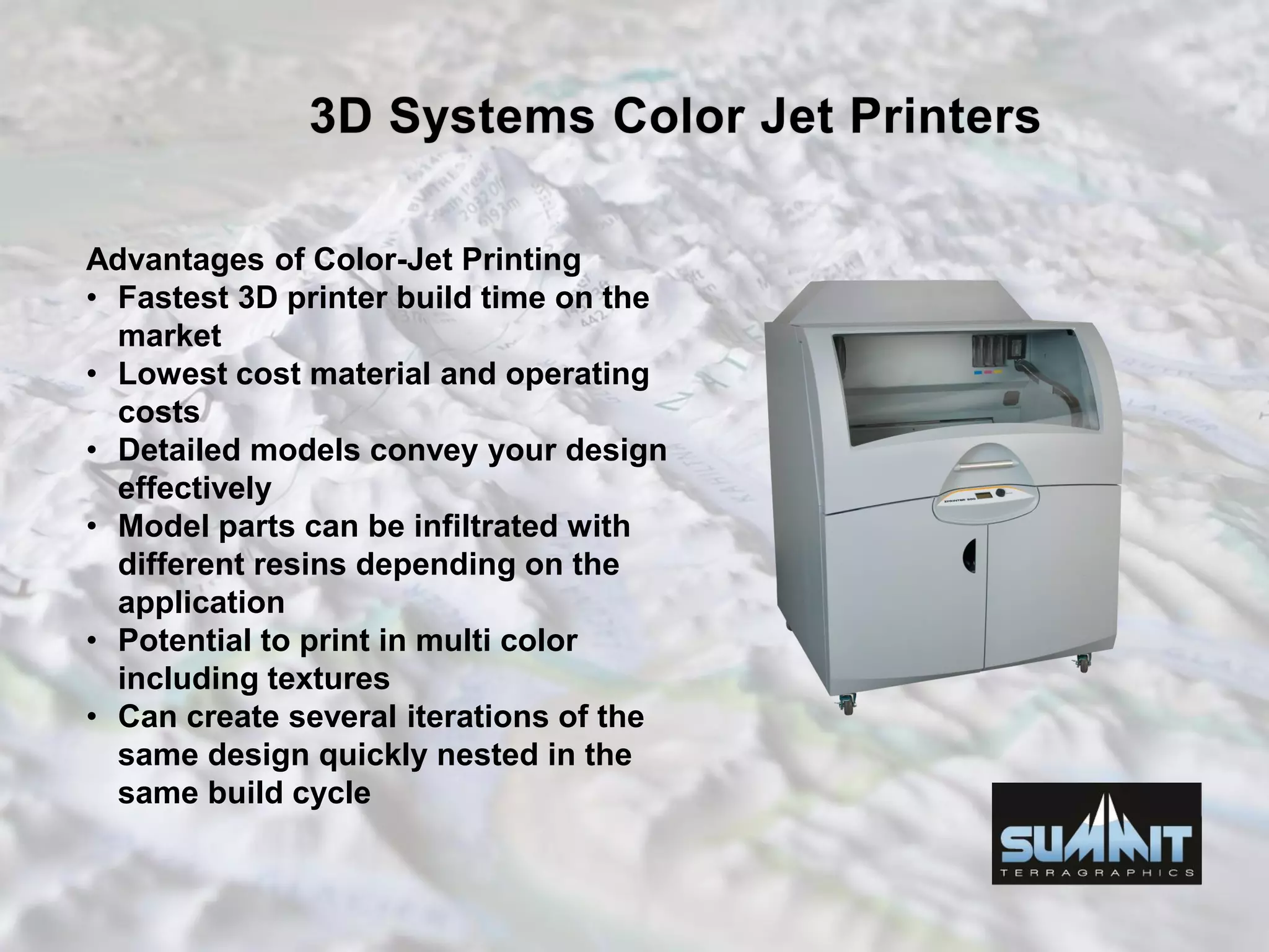
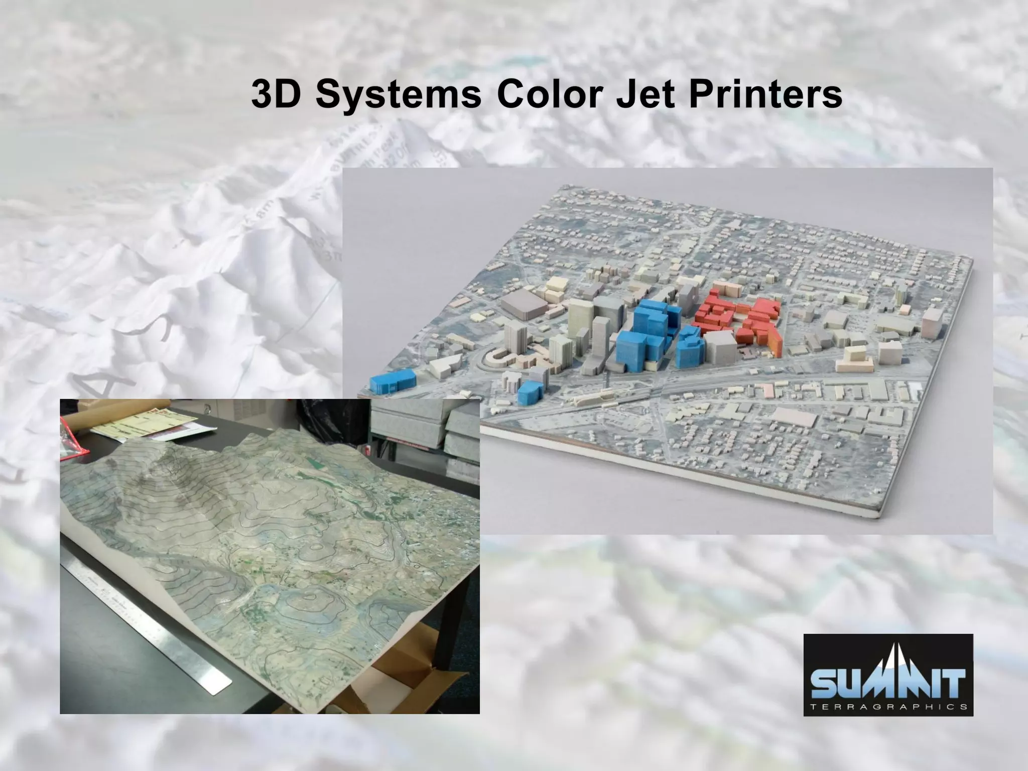
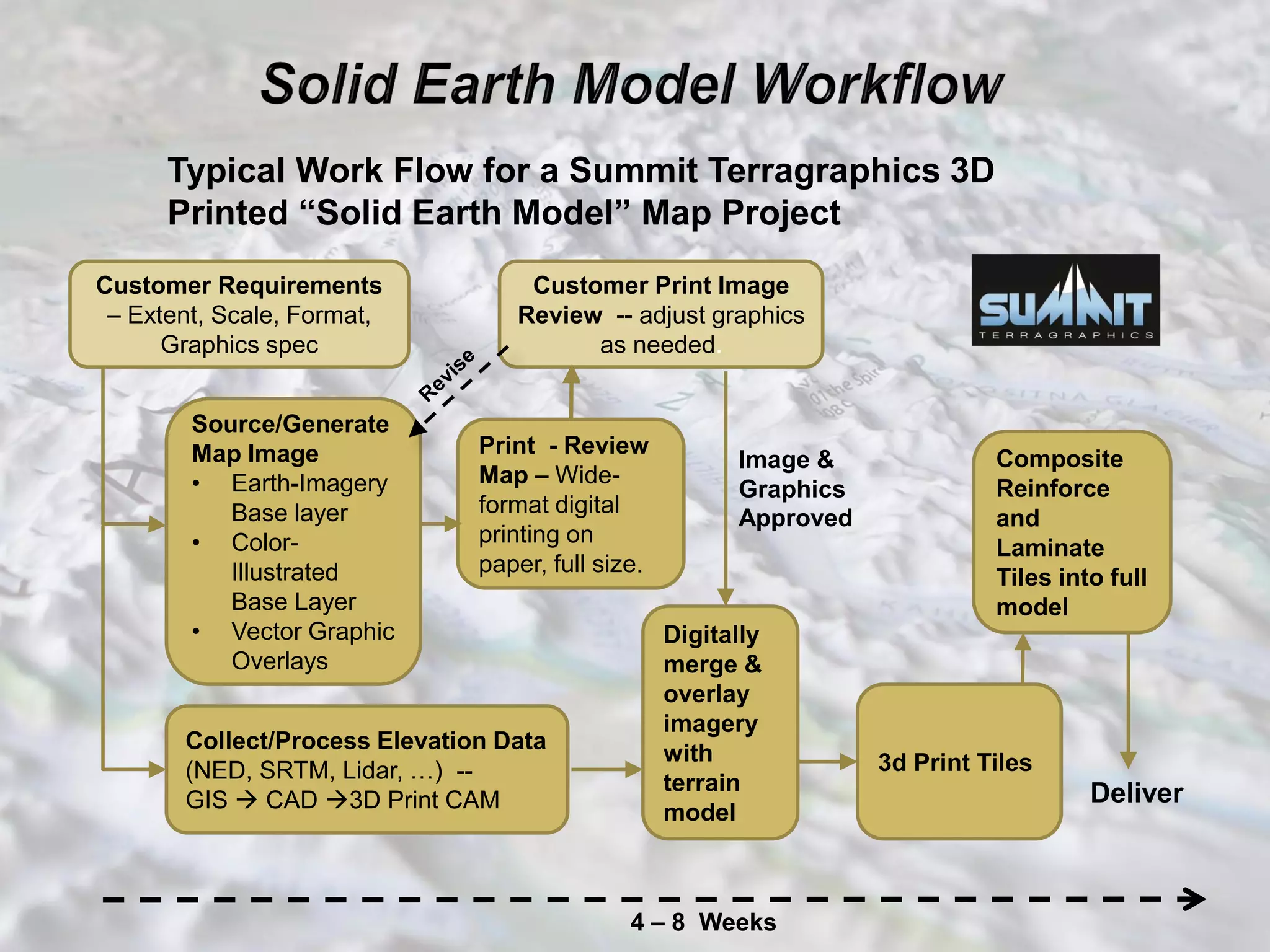
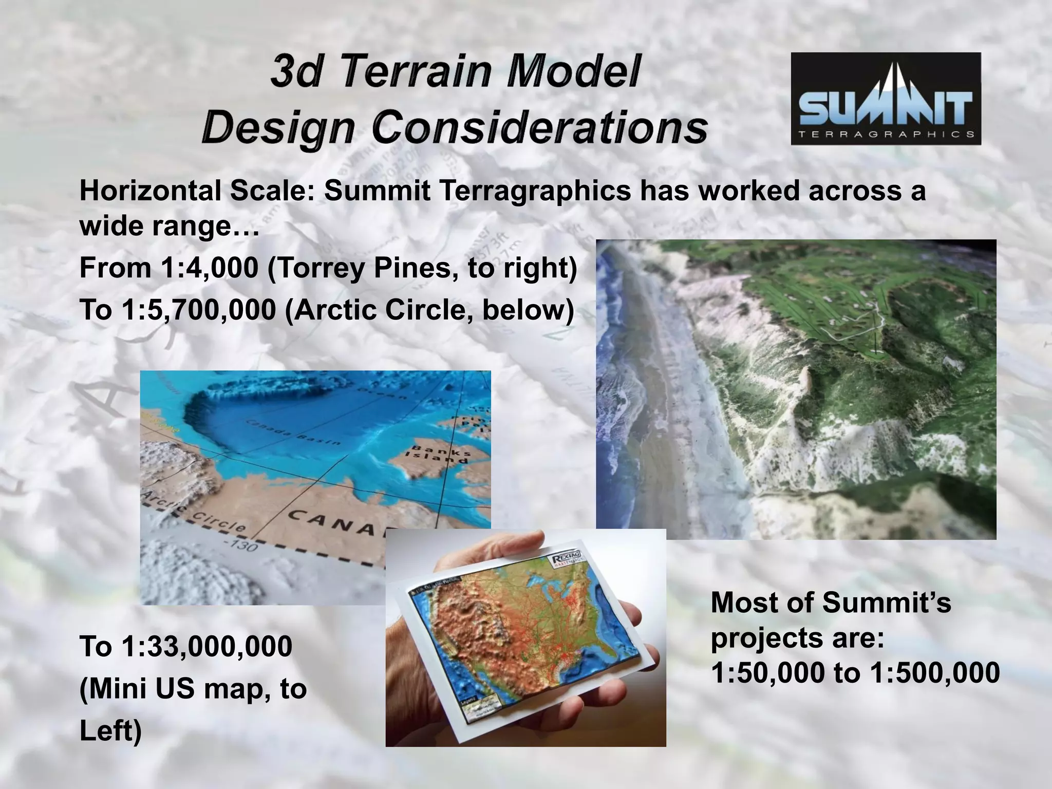
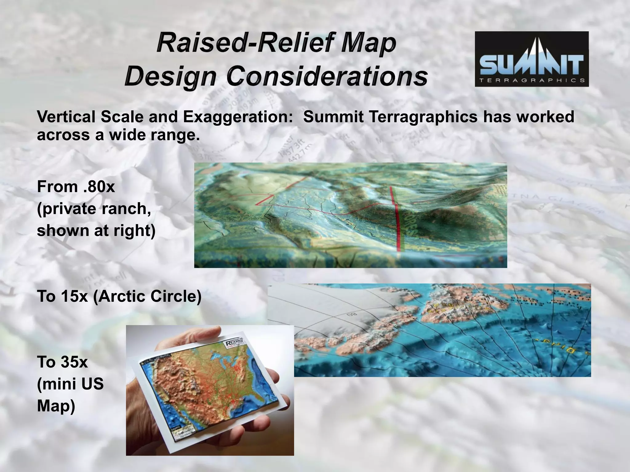
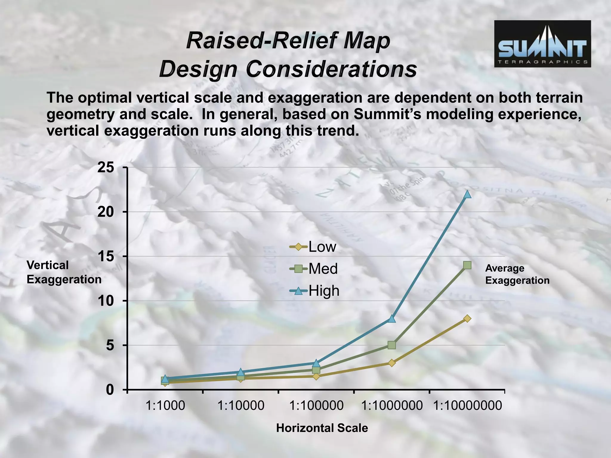
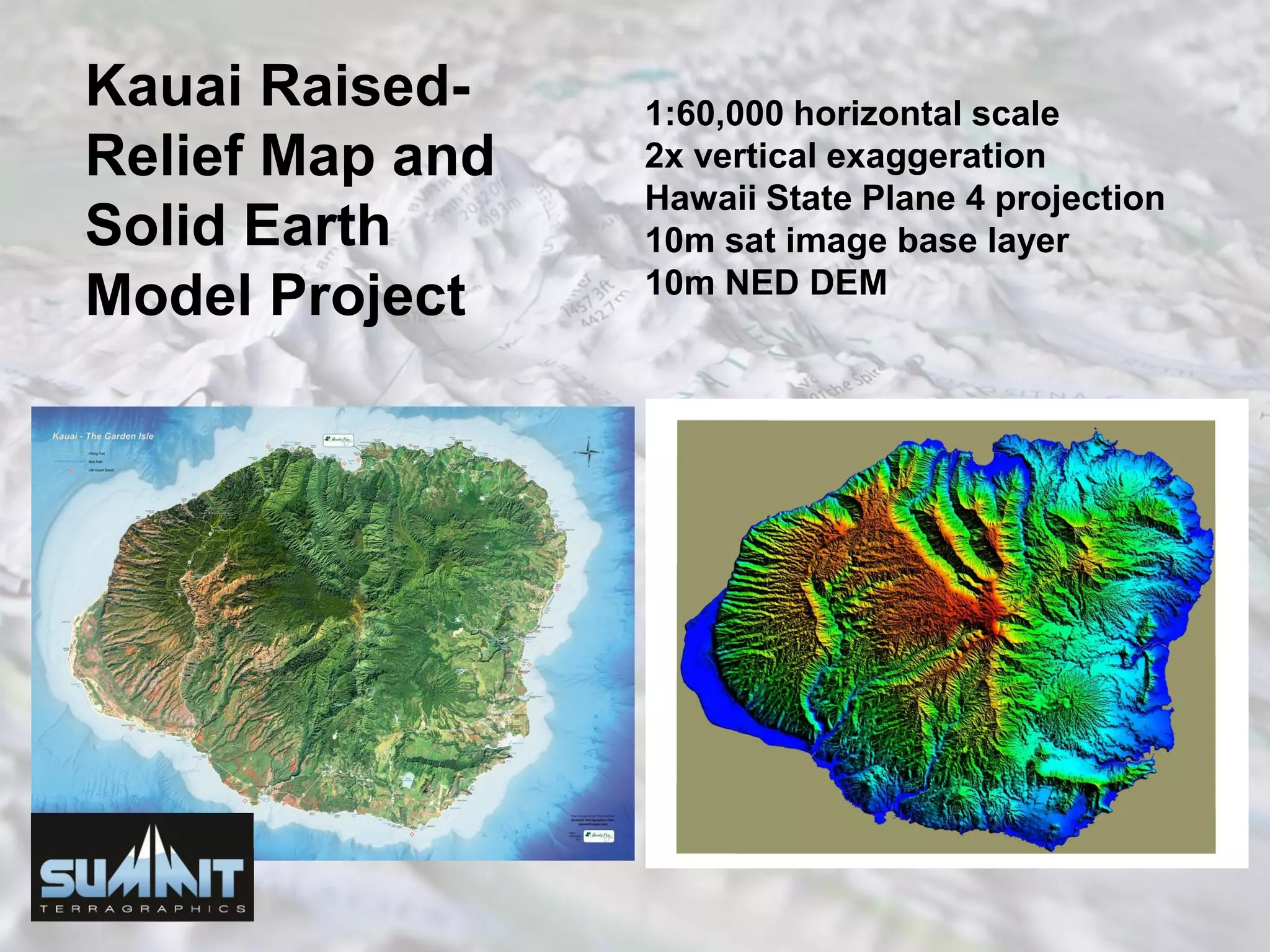
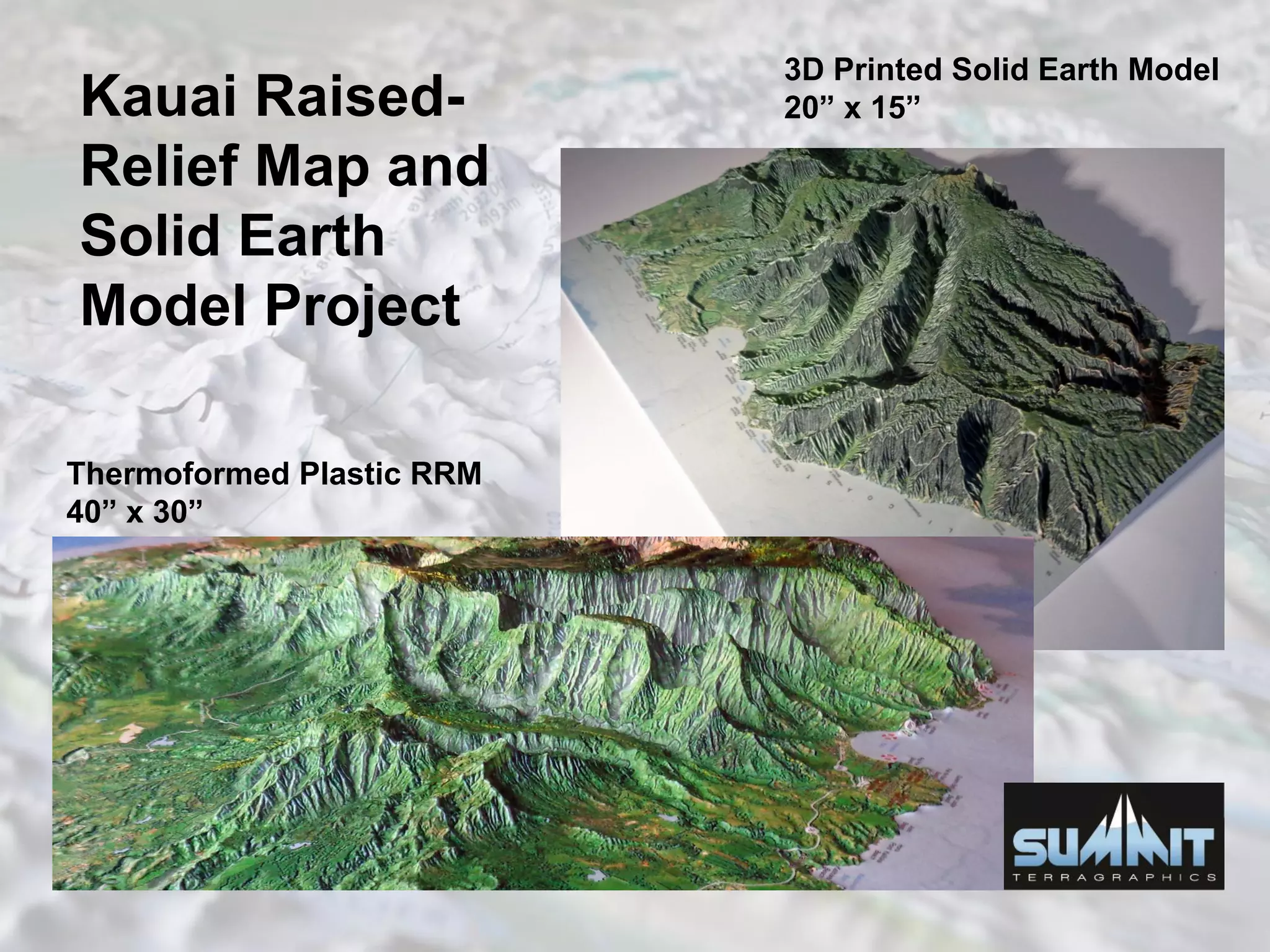
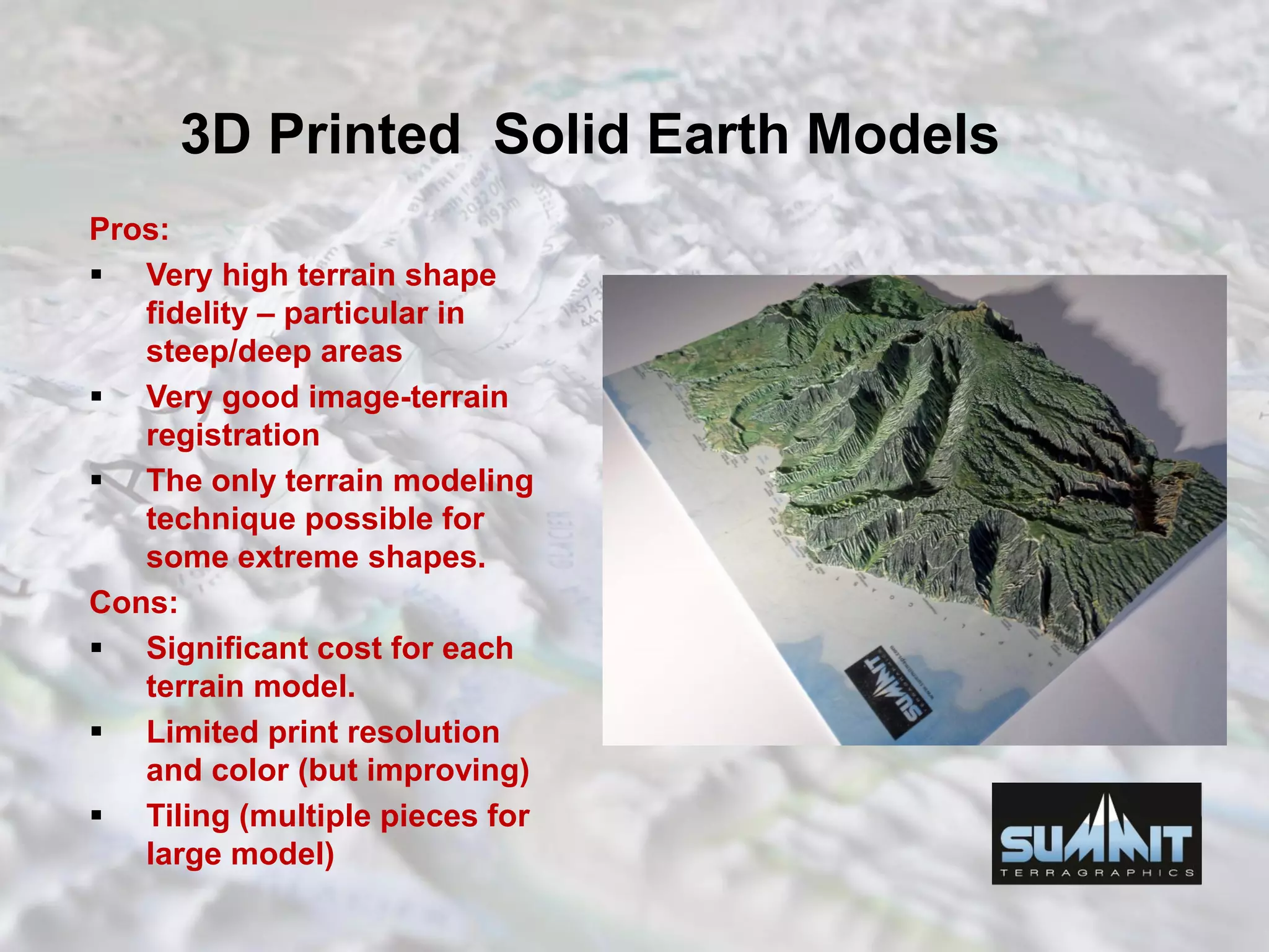
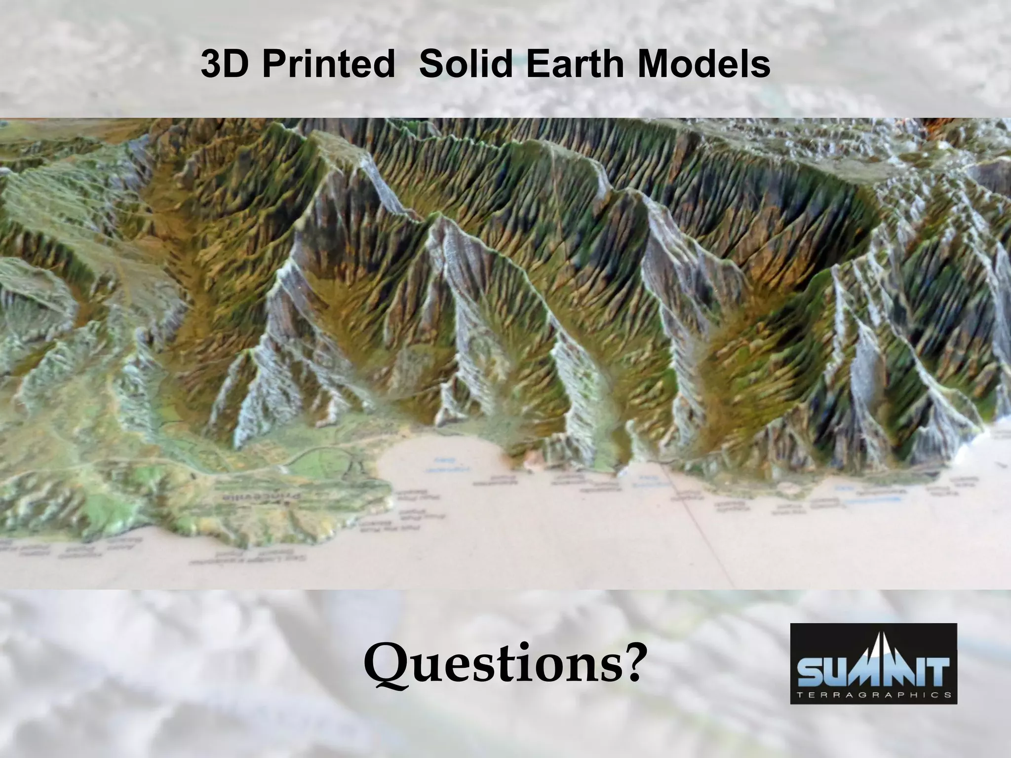
Presented by:
Michael Higgins
Summit Terragraphics Inc.
NACIS Annual Meeting
Colorado Springs CO, October 2016
www.summitmaps.com
• Who is Summit?
• Why use 3d maps?
• Thermoformed Raised-Relief Maps, Pros &
Cons
• What is 3d Printing?
• 3d Printing Technologies
• Summit 3d Printed Terrain Model Work Flow
• 3d Terrain Model Design Considerations
• Kauai Terrain Model
• 3d Printed Terrain Models – Summary
Summit is a leading designer and manufacturer of thermoformed
raised-relief maps for National Parks and recreation areas,
government/military, corporations, and individuals.
Up to 50” x 35” 3D area.
Up to 3” – 4” of relief.
Core Technology -- 3D printed thermoform terrain molds –
extreme resolution and accuracy with economical cost.
Key Advantage of Thermoformed 3d Maps – low cost production
once design/tooling is complete.
“Flat” methods of presenting terrain can be very effective – as
shown in the samples below. But at times using a 3D model
greatly eases interpretation of complex terrain, particularly for
the untrained eye.
Contour Lines
Shaded Relief
Elevation Color-Ramp
Combined Topo – Shaded
Relief
The original National Park
Service 2D flat map of Glacier
Bay National Park is shown at
right. Summit very effectively
converted this map to a raised-
relief format shown below.
Notice on the raised-relief map
how easy it is to quickly
understand and interpret the
complex and rugged terrain.
Sampling of products:
At left, Afghanistan/Pakistan
border region, 3D raised-
relief map. 1:250k scale
At right, a raised-relief map of
the Torrey Pines Golf Course.
1:4k scale.
Sampling of products:
At right, a raised-relief map
of Upper Glacier Bay,
Glacier Bay National Park,
produced for the US
National Park Service.
At left, a full contiguous
US 3d Map. 1:4.4M
scale.
Printed & thermoformed plastic sheets
Pros:
 High print image
quality.
 Accurate terrain
modeling.
 Low per map
production cost.
Cons:
 Significant tooling
costs.
 Challenging image-
terrain registration with
extreme relief (deep
canyons/valleys).
3d Printed Models
Afghanistan 3d Map
Additive manufacturing is defined as the process of
joining materials to make objects from 3D model data,
usually layer upon layer, as opposed to subtractive
manufacturing methodologies. (ASTM F2792)
Conventional manufacturing techniques are mostly
subtractive. You start with a block or panel of
material and cut, route, etch and grind away
material to make your object. Or sheets of material
are deformed around a mold.
Ref: John Lee, ABC Imaging
Among the advantages in many industrial niches
and design practices:
Complex geometry with internal cavities
impossible to fabricate by any other method.
Setup/Tooling cost and time needed for a new
unique design is much less.
Generally less material waste.
Manufacture parts on demand, as needed. No
need for keeping inventory and shipping. Local
manufacturing.
Ref: John Lee, ABC Imaging
 Not for mass production; it’s for mass customization.
 The 1,000th copy costs essentially the same as the 1st copy in
terms of materials and machine time. No economies of
scale.
 Poor substitute for traditional manufacturing in some cases.
Earliest 3D Printers were used for rapid prototyping mostly.
 High material costs can make larger parts prohibitively
expensive. “Razor and Blades” business model pervades
the industry. With few exceptions you must buy proprietary
materials from the machine manufacturer.
Ref: John Lee, ABC Imaging
Per ASTM International Committee F42:
Seven AM Process Categories
i. Binder Jetting* (multi color capable) (Color Jet Printing)
ii. Directed Energy Deposition
iii. Material Extrusion
iv. Material Jetting
v. Powder Bed Fusion
vi. Sheet Lamination* (multi color capable)
vii. Vat Photopolymerization
And within some of the categories,
there are three classes of machine models.
o Production
o Professional
o Personal
Ref: John Lee, ABC Imaging
Advantages of Color-Jet Printing
• Fastest 3D printer build time on the
market
• Lowest cost material and operating
costs
• Detailed models convey your design
effectively
• Model parts can be infiltrated with
different resins depending on the
application
• Potential to print in multi color
including textures
• Can create several iterations of the
same design quickly nested in the
same build cycle
Typical Work Flow for a Summit Terragraphics 3D
Printed “Solid Earth Model” Map Project
Customer Requirements
– Extent, Scale, Format,
Graphics spec
Source/Generate
Map Image
• Earth-Imagery
Base layer
• Color-
Illustrated
Base Layer
• Vector Graphic
Overlays
Collect/Process Elevation Data
(NED, SRTM, Lidar, …) --
GIS  CAD 3D Print CAM
Digitally
merge &
overlay
imagery
with
terrain
model
Print - Review
Map – Wide-
format digital
printing on
paper, full size.
4 – 8 Weeks
Customer Print Image
Review -- adjust graphics
as needed.
Composite
Reinforce
and
Laminate
Tiles into full
model
3d Print Tiles
Deliver
Image &
Graphics
Approved
DEM resolution needed?
100 dpi good (12 meter resolution for a 1:50k model)
50 dpi OK
Sometimes lower
Horizontal Scale: Summit Terragraphics has worked across a
wide range…
From 1:4,000 (Torrey Pines, to right)
To 1:5,700,000 (Arctic Circle, below)
To 1:33,000,000
(Mini US map, to
Left) Most
Most of Summit’s
projects are:
1:50,000 to 1:500,000
Vertical Scale and Exaggeration: Summit Terragraphics has worked
across a wide range.
From .80x
(private ranch,
shown at right)
To 15x (Arctic Circle)
To 35x
(mini US
Map)
The optimal vertical scale and exaggeration are dependent on both terrain
geometry and scale. In general, based on Summit’s modeling experience,
vertical exaggeration runs along this trend.
Average
Exaggeration
0
5
10
15
20
25
1:1000 1:10000 1:100000 1:1000000 1:10000000
Low
Med
High
Vertical
Exaggeration
Horizontal Scale
Kauai Raised-
Relief Map and
Solid Earth
Model Project
1:60,000 horizontal scale
2x vertical exaggeration
Hawaii State Plane 4 projection
10m sat image base layer
10m NED DEM
Kauai Raised-
Relief Map and
Solid Earth
Model Project
Thermoformed Plastic RRM
40” x 30”
3D Printed Solid Earth Model
20” x 15”
3D Printed Solid Earth Models
Pros:
 Very high terrain shape
fidelity – particular in
steep/deep areas
 Very good image-terrain
registration
 The only terrain modeling
technique possible for
some extreme shapes.
Cons:
 Significant cost for each
terrain model.
 Limited print resolution
and color (but improving)
 Tiling (multiple pieces for
large model)
3D Printed Solid Earth Models
Questions?

3D Printed Terrain Models and Maps -- Current State of Technology and Challenges

  • 1.
    Presented by: Michael Higgins SummitTerragraphics Inc. NACIS Annual Meeting Colorado Springs CO, October 2016 www.summitmaps.com
  • 2.
    • Who isSummit? • Why use 3d maps? • Thermoformed Raised-Relief Maps, Pros & Cons • What is 3d Printing? • 3d Printing Technologies • Summit 3d Printed Terrain Model Work Flow • 3d Terrain Model Design Considerations • Kauai Terrain Model • 3d Printed Terrain Models – Summary
  • 3.
    Summit is aleading designer and manufacturer of thermoformed raised-relief maps for National Parks and recreation areas, government/military, corporations, and individuals. Up to 50” x 35” 3D area. Up to 3” – 4” of relief. Core Technology -- 3D printed thermoform terrain molds – extreme resolution and accuracy with economical cost. Key Advantage of Thermoformed 3d Maps – low cost production once design/tooling is complete.
  • 4.
    “Flat” methods ofpresenting terrain can be very effective – as shown in the samples below. But at times using a 3D model greatly eases interpretation of complex terrain, particularly for the untrained eye. Contour Lines Shaded Relief Elevation Color-Ramp Combined Topo – Shaded Relief
  • 5.
    The original NationalPark Service 2D flat map of Glacier Bay National Park is shown at right. Summit very effectively converted this map to a raised- relief format shown below. Notice on the raised-relief map how easy it is to quickly understand and interpret the complex and rugged terrain.
  • 6.
    Sampling of products: Atleft, Afghanistan/Pakistan border region, 3D raised- relief map. 1:250k scale At right, a raised-relief map of the Torrey Pines Golf Course. 1:4k scale.
  • 7.
    Sampling of products: Atright, a raised-relief map of Upper Glacier Bay, Glacier Bay National Park, produced for the US National Park Service. At left, a full contiguous US 3d Map. 1:4.4M scale.
  • 8.
    Printed & thermoformedplastic sheets Pros:  High print image quality.  Accurate terrain modeling.  Low per map production cost. Cons:  Significant tooling costs.  Challenging image- terrain registration with extreme relief (deep canyons/valleys). 3d Printed Models Afghanistan 3d Map
  • 9.
    Additive manufacturing isdefined as the process of joining materials to make objects from 3D model data, usually layer upon layer, as opposed to subtractive manufacturing methodologies. (ASTM F2792) Conventional manufacturing techniques are mostly subtractive. You start with a block or panel of material and cut, route, etch and grind away material to make your object. Or sheets of material are deformed around a mold. Ref: John Lee, ABC Imaging
  • 10.
    Among the advantagesin many industrial niches and design practices: Complex geometry with internal cavities impossible to fabricate by any other method. Setup/Tooling cost and time needed for a new unique design is much less. Generally less material waste. Manufacture parts on demand, as needed. No need for keeping inventory and shipping. Local manufacturing. Ref: John Lee, ABC Imaging
  • 11.
     Not formass production; it’s for mass customization.  The 1,000th copy costs essentially the same as the 1st copy in terms of materials and machine time. No economies of scale.  Poor substitute for traditional manufacturing in some cases. Earliest 3D Printers were used for rapid prototyping mostly.  High material costs can make larger parts prohibitively expensive. “Razor and Blades” business model pervades the industry. With few exceptions you must buy proprietary materials from the machine manufacturer. Ref: John Lee, ABC Imaging
  • 12.
    Per ASTM InternationalCommittee F42: Seven AM Process Categories i. Binder Jetting* (multi color capable) (Color Jet Printing) ii. Directed Energy Deposition iii. Material Extrusion iv. Material Jetting v. Powder Bed Fusion vi. Sheet Lamination* (multi color capable) vii. Vat Photopolymerization And within some of the categories, there are three classes of machine models. o Production o Professional o Personal Ref: John Lee, ABC Imaging
  • 13.
    Advantages of Color-JetPrinting • Fastest 3D printer build time on the market • Lowest cost material and operating costs • Detailed models convey your design effectively • Model parts can be infiltrated with different resins depending on the application • Potential to print in multi color including textures • Can create several iterations of the same design quickly nested in the same build cycle
  • 15.
    Typical Work Flowfor a Summit Terragraphics 3D Printed “Solid Earth Model” Map Project Customer Requirements – Extent, Scale, Format, Graphics spec Source/Generate Map Image • Earth-Imagery Base layer • Color- Illustrated Base Layer • Vector Graphic Overlays Collect/Process Elevation Data (NED, SRTM, Lidar, …) -- GIS  CAD 3D Print CAM Digitally merge & overlay imagery with terrain model Print - Review Map – Wide- format digital printing on paper, full size. 4 – 8 Weeks Customer Print Image Review -- adjust graphics as needed. Composite Reinforce and Laminate Tiles into full model 3d Print Tiles Deliver Image & Graphics Approved
  • 16.
    DEM resolution needed? 100dpi good (12 meter resolution for a 1:50k model) 50 dpi OK Sometimes lower
  • 17.
    Horizontal Scale: SummitTerragraphics has worked across a wide range… From 1:4,000 (Torrey Pines, to right) To 1:5,700,000 (Arctic Circle, below) To 1:33,000,000 (Mini US map, to Left) Most Most of Summit’s projects are: 1:50,000 to 1:500,000
  • 18.
    Vertical Scale andExaggeration: Summit Terragraphics has worked across a wide range. From .80x (private ranch, shown at right) To 15x (Arctic Circle) To 35x (mini US Map)
  • 19.
    The optimal verticalscale and exaggeration are dependent on both terrain geometry and scale. In general, based on Summit’s modeling experience, vertical exaggeration runs along this trend. Average Exaggeration 0 5 10 15 20 25 1:1000 1:10000 1:100000 1:1000000 1:10000000 Low Med High Vertical Exaggeration Horizontal Scale
  • 20.
    Kauai Raised- Relief Mapand Solid Earth Model Project 1:60,000 horizontal scale 2x vertical exaggeration Hawaii State Plane 4 projection 10m sat image base layer 10m NED DEM
  • 21.
    Kauai Raised- Relief Mapand Solid Earth Model Project Thermoformed Plastic RRM 40” x 30” 3D Printed Solid Earth Model 20” x 15”
  • 22.
    3D Printed SolidEarth Models Pros:  Very high terrain shape fidelity – particular in steep/deep areas  Very good image-terrain registration  The only terrain modeling technique possible for some extreme shapes. Cons:  Significant cost for each terrain model.  Limited print resolution and color (but improving)  Tiling (multiple pieces for large model)
  • 23.
    3D Printed SolidEarth Models Questions?