Download as PDF, PPTX

![getCurrentPosition
It returns the device's current position
getCurrentPosition(win, [fail], [options]);
win
callback function with a Position parameter
fail
error callback
options
geolocation options](https://image.slidesharecdn.com/15geo-140526055906-phpapp01/85/Geolocation-and-mapping-using-Google-Maps-services-10-320.jpg)
![watchPosition
It gets the device's position when a change in position has been
detected
var id = watchPosition(win, [fail], [options]);
win
callback function with a Position parameter
fail
error callback
options
geolocation options](https://image.slidesharecdn.com/15geo-140526055906-phpapp01/85/Geolocation-and-mapping-using-Google-Maps-services-11-320.jpg)
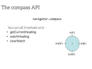
![getCurrentHeading
getCurrentHeading(win,
[fail],
[options]);
It detects the direction or heading that the device is pointed
from the top of the device
win
callback function with an Heading parameter
fail
error callback
options
compass options](https://image.slidesharecdn.com/15geo-140526055906-phpapp01/85/Geolocation-and-mapping-using-Google-Maps-services-21-320.jpg)
![watchHeading
var
id
=
watchHeading(win,
[fail],
[options]);
It gets the device's heading at a regular interval
win
callback function with an Heading parameter
fail
error callback
options
compass options](https://image.slidesharecdn.com/15geo-140526055906-phpapp01/85/Geolocation-and-mapping-using-Google-Maps-services-22-320.jpg)

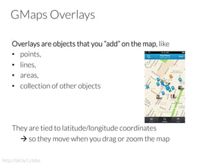
![Polylines Options
• path[]
– array of LatLng, one for each point of the polyline
• strokeColor
– color of the lines in CSS syntax
• strokeOpacity
– opacity of the lines as a decimal number between 0 and 1
• strokeWeight
– the weight of the line's stroke in pixels
• editable
– boolean, specifies whether users can modify it or not](https://image.slidesharecdn.com/15geo-140526055906-phpapp01/85/Geolocation-and-mapping-using-Google-Maps-services-51-320.jpg)
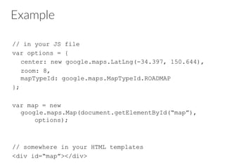
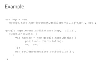
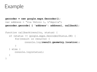
![Example
var map; // the map object (initialization omitted here)
var coords = [
new google.maps.LatLng(37.772323, -122.214897),
new google.maps.LatLng(21.291982, -157.821856),
new google.maps.LatLng(-18.142599, 178.431),
new google.maps.LatLng(-27.46758, 153.027892)
];
var polyline = new google.maps.Polyline({
path: coords,
strokeColor: "#00FF00",
strokeOpacity: 1.0,
strokeWeight: 1
});
polyline.setMap(map);](https://image.slidesharecdn.com/15geo-140526055906-phpapp01/85/Geolocation-and-mapping-using-Google-Maps-services-52-320.jpg)
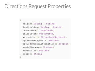

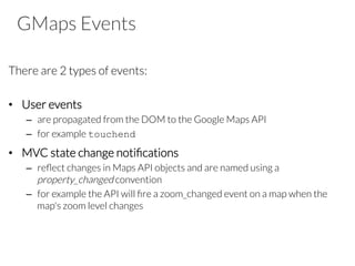
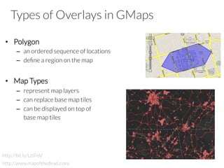
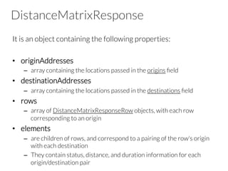
![Routes
It is an object literal with the following fields:
• legs[]: array of DirectionsLeg objects
• waypoint_order[]: indicates the order of waypoints
• overview_path[]: array of LatLngs approximating the path of
the resulting directions
• bounds: LatLngBounds containing the route
• copyrights: text
• warnings: text](https://image.slidesharecdn.com/15geo-140526055906-phpapp01/85/Geolocation-and-mapping-using-Google-Maps-services-59-320.jpg)
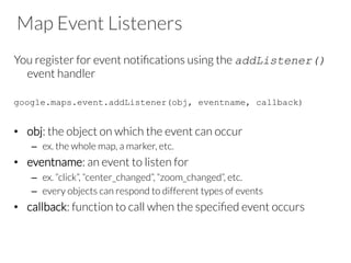
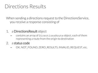
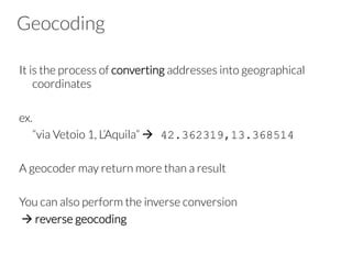
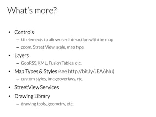
![Legs
It is an object literal with the following fields:
• steps[]: array of DirectionsStep objects
• distance: total distance covered by this leg
• duration: total duration of the leg
• start_location: the origin of the leg as LatLng
• end_location: the destination of the leg as LatLng
• start_address: the origin of the leg as text
• end_address: the destination of the leg as text](https://image.slidesharecdn.com/15geo-140526055906-phpapp01/85/Geolocation-and-mapping-using-Google-Maps-services-60-320.jpg)
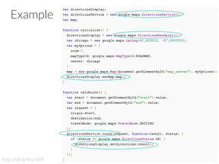
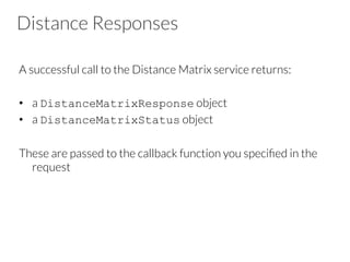
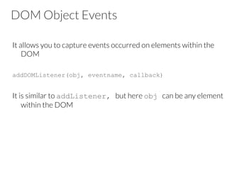
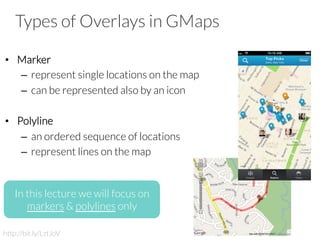
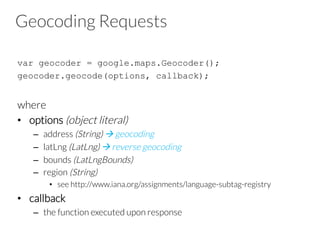
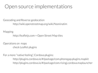
![Example
var origin = “L’Aquila, Italy";
var destination = “London, England";
var service = new google.maps.DistanceMatrixService();
service.getDistanceMatrix({
origins: [origin],
destinations: [destination],
travelMode: google.maps.TravelMode.DRIVING,
avoidHighways: false,
avoidTolls: false
}, callback);
function callback(response, status) {
if (status == google.maps.DistanceMatrixStatus.OK) {
var t = response.rows[0].elements[0].distance.text;
alert(t);
}
}](https://image.slidesharecdn.com/15geo-140526055906-phpapp01/85/Geolocation-and-mapping-using-Google-Maps-services-68-320.jpg)


The document provides an overview of geolocation and mapping using Google Maps services, covering the concepts of geolocation, mapping, and relevant APIs available in Cordova for accessing location and heading data. It details the methods and objects associated with geolocation, such as retrieving current positions and managing events in mapping, as well as showcasing how to manipulate Google Maps through various utilities, markers, polylines, and service requests for directions and distance calculations. Additionally, it illustrates practical examples using JavaScript to implement these functionalities.
![[2015/2016] Geolocation and mapping](https://cdn.slidesharecdn.com/ss_thumbnails/06bgeo-160413121805-thumbnail.jpg?width=640&height=640&fit=bounds)


![How Maintainability Issues of Android Apps Evolve [ICSME 2018]](https://cdn.slidesharecdn.com/ss_thumbnails/icsme2018-180928081558-thumbnail.jpg?width=640&height=640&fit=bounds)


![Modeling objects interaction via UML sequence diagrams [Software Design] [Com...](https://cdn.slidesharecdn.com/ss_thumbnails/06sequencediagrams-180314152521-thumbnail.jpg?width=640&height=640&fit=bounds)
![Modeling behaviour via UML state machines [Software Design] [Computer Science...](https://cdn.slidesharecdn.com/ss_thumbnails/05statemachines-180306225932-thumbnail.jpg?width=640&height=640&fit=bounds)
![Object-oriented design patterns in UML [Software Design] [Computer Science] [...](https://cdn.slidesharecdn.com/ss_thumbnails/04designpatterns-180228160652-thumbnail.jpg?width=640&height=640&fit=bounds)
![Structure modeling with UML [Software Design] [Computer Science] [Vrije Unive...](https://cdn.slidesharecdn.com/ss_thumbnails/03structuremodeling-180219151135-thumbnail.jpg?width=640&height=640&fit=bounds)
![Requirements engineering with UML [Software Design] [Computer Science] [Vrije...](https://cdn.slidesharecdn.com/ss_thumbnails/02requirements-180213083117-thumbnail.jpg?width=640&height=640&fit=bounds)
![Modeling and abstraction, software development process [Software Design] [Com...](https://cdn.slidesharecdn.com/ss_thumbnails/01intro-180206151252-thumbnail.jpg?width=640&height=640&fit=bounds)
![[2017/2018] Agile development](https://cdn.slidesharecdn.com/ss_thumbnails/ivano05agiledevelopment-171123214423-thumbnail.jpg?width=640&height=640&fit=bounds)

![[2017/2018] AADL - Architecture Analysis and Design Language](https://cdn.slidesharecdn.com/ss_thumbnails/ivano04saaadl-171122165132-thumbnail.jpg?width=640&height=640&fit=bounds)
![[2017/2018] Architectural languages](https://cdn.slidesharecdn.com/ss_thumbnails/ivano03salanguages-171122083931-thumbnail.jpg?width=640&height=640&fit=bounds)
![[2017/2018] Introduction to Software Architecture](https://cdn.slidesharecdn.com/ss_thumbnails/ivano02softwarearchitecture-171120182731-thumbnail.jpg?width=640&height=640&fit=bounds)


