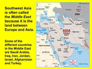
Southwest Asia
is oftencalled
the Middle East
because it is the
land between
Europe and Asia.
Some of the
different countries
in the Middle East
are Saudi Arabia,
Iraq, Iran, Jordan,
Israel, Afghanistan
and Turkey.
3.
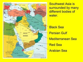
Southwest Asia is
surroundedby many
different bodies of
water.
Black Sea
Persian Gulf
Mediterranean Sea
Red Sea
Arabian Sea
4.
All of thedifferent bodies of water that surround
Southwest Asia have resulted in much of the land being
carved into 2 peninsulas.
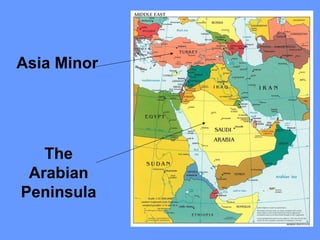
The Arabian
Peninsula
-Countries of
Saudi Arabia,
Yemen, Oman,
and United Arab
Emirates
-Surrounded by
5 different
bodies of water
Asia Minor
-Location of
Turkey
-Surrounded by
the Black Sea
and the
Mediterranean
Sea.
5.
Questions 1-3
• 1.What bodies of water border the
Arabian Peninsula?
• 2. The middle east separates what two
large land masses?
• 3. What two geographic features make up
a majority of Southwest Asia
The Dead Seais located
along the border of the
West Bank, Jordan, and
Israel and is the lowest
point below sea level in
Eurasia.
The Dead Sea is famous
because it is one of the
saltiest bodies of water on
earth with a salinity 8
times greater than the
average ocean salinity.
The large amount of salt
means that any person
who goes into the sea can
float!
The Dead Sea
But be careful, just like any
other salt water, the water will
sting cuts and will cause
severe pain if it gets in your
eyes!!!
8.
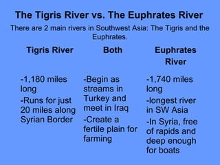
The Tigris Rivervs. The Euphrates River
There are 2 main rivers in Southwest Asia: The Tigris and the
Euphrates.
Tigris River Both Euphrates
River
-1,180 miles
long
-Runs for just
20 miles along
Syrian Border
-Begin as
streams in
Turkey and
meet in Iraq
-Create a
fertile plain for
farming
-1,740 miles
long
-longest river
in SW Asia
-In Syria, free
of rapids and
deep enough
for boats
9.
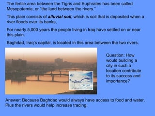
The fertile areabetween the Tigris and Euphrates has been called
Mesopotamia, or “the land between the rivers.”
This plain consists of alluvial soil, which is soil that is deposited when a
river floods over its banks,
For nearly 5,000 years the people living in Iraq have settled on or near
this plain.
Baghdad, Iraq’s capital, is located in this area between the two rivers.
Question: How
would building a
city in such a
location contribute
to its success and
importance?
Answer: Because Baghdad would always have access to food and water.
Plus the rivers would help increase trading.
10.
Questions 4-6
• 4.Why is the name of the Dead Sea and
the Caspian Sea misleading? (hint: you
may need your book)
• 5. Why are the Tigris and Euphrates rivers
called “The cradle of civilization?”
• 6. How have the Tigris and Euphrates
rivers helped Iraq’s agriculture?
11.
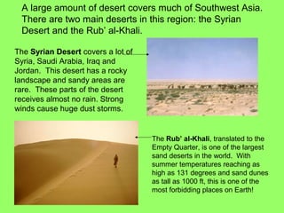
A large amountof desert covers much of Southwest Asia.
There are two main deserts in this region: the Syrian
Desert and the Rub’ al-Khali.
The Syrian Desert covers a lot of
Syria, Saudi Arabia, Iraq and
Jordan. This desert has a rocky
landscape and sandy areas are
rare. These parts of the desert
receives almost no rain. Strong
winds cause huge dust storms.
The Rub’ al-Khali, translated to the
Empty Quarter, is one of the largest
sand deserts in the world. With
summer temperatures reaching as
high as 131 degrees and sand dunes
as tall as 1000 ft, this is one of the
most forbidding places on Earth!
12.
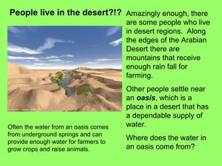
People live inthe desert?!? Amazingly enough, there
are some people who live
in desert regions. Along
the edges of the Arabian
Desert there are
mountains that receive
enough rain fall for
farming.
Other people settle near
an oasis, which is a
place in a desert that has
a dependable supply of
water.
Where does the water in
an oasis come from?
Often the water from an oasis comes
from underground springs and can
provide enough water for farmers to
grow crops and raise animals.
13.
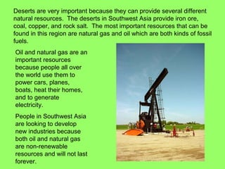
Deserts are veryimportant because they can provide several different
natural resources. The deserts in Southwest Asia provide iron ore,
coal, copper, and rock salt. The most important resources that can be
found in this region are natural gas and oil which are both kinds of fossil
fuels.
Oil and natural gas are an
important resources
because people all over
the world use them to
power cars, planes,
boats, heat their homes,
and to generate
electricity.
People in Southwest Asia
are looking to develop
new industries because
both oil and natural gas
are non-renewable
resources and will not last
forever.
14.
Even though SouthwestAsia is
surrounded by large amounts of water, it
is all salt which can’t be used for drinking
or farming. This means that fresh water
is a very rare and precious resource to
the people who live in Southwest Asia.
To many people it is more important than
oil.
15.
Questions 7-10
• 7.List two differences between the Syrian
Desert and the Rub’ al-Khali Desert.
• 8. What are two ways people have
adapted to living in a desert?
• 9. What is the desert’s most important
resource to the Western World? Why?
• 10. What is the desert’s most important
resource to people of the desert? Why?
16.
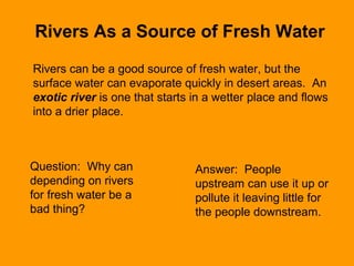
Rivers As aSource of Fresh Water
Rivers can be a good source of fresh water, but the
surface water can evaporate quickly in desert areas. An
exotic river is one that starts in a wetter place and flows
into a drier place.
Question: Why can
depending on rivers
for fresh water be a
bad thing?
Answer: People
upstream can use it up or
pollute it leaving little for
the people downstream.
17.
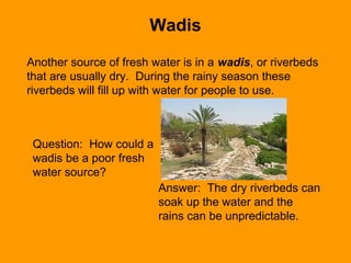
Another source offresh water is in a wadis, or riverbeds
that are usually dry. During the rainy season these
riverbeds will fill up with water for people to use.
Question: How could a
wadis be a poor fresh
water source?
Answer: The dry riverbeds can
soak up the water and the
rains can be unpredictable.
Wadis
18.
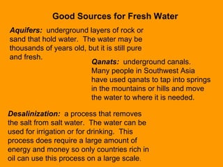
Good Sources forFresh Water
Aquifers: underground layers of rock or
sand that hold water. The water may be
thousands of years old, but it is still pure
and fresh.
Qanats: underground canals.
Many people in Southwest Asia
have used qanats to tap into springs
in the mountains or hills and move
the water to where it is needed.
Desalinization: a process that removes
the salt from salt water. The water can be
used for irrigation or for drinking. This
process does require a large amount of
energy and money so only countries rich in
oil can use this process on a large scale.
19.
Questions 11-12
• 11.Describe the three processes people
of the desert use to gather fresh water
where there is no stream or wadis.
• 12. List all naturally occuring water
sources and list all human-made water
sources. What is the difference between
the two?
• 13. Which water sources are reliable and
unreliable?