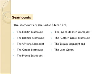
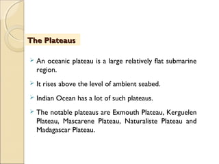
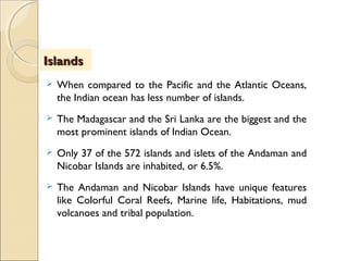
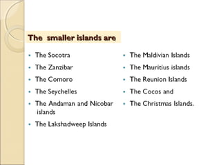
Course Title : Earth Science
Paper Title : Oceanography
The Indian OceanThe Indian Ocean
By
Prof.A. Balasubramanian
Centre for Advanced Studies in Earth Science
University of Mysore, India
Table of ContentsTable of Contents
 After attending this lesson, the learner should be able to
comprehend about the geographic setting of the Indian
ocean, its dimension, associated water masses,
morphological features of the ocean floor, very
significant conditions of the ocean, sediments, marine
life, marine pollution and other hazards.
 In addition, the user should be able to understand, the
importance of the Indian Ocean in the context of global
activities including the historical oceanographic
explorations.
ObjectivesObjectives
 Oceans are the fascinating zones of the planet earth.
 Oceans provide a lot of natural resources and benefits to
the life and environment. The study of oceanography
involves a basic understanding of all the oceans in the
world.
 The Indian Ocean is the third largest ocean in the world. It
is next to the Pacific and the Atlantic Oceans, in terms of
its areal extension. This ocean is named after its close
geographic proximity to India. The Indian Ocean covers
about 14% of the Earth’s Surface.
IntroductionIntroduction
(…Contd)
 It is enclosed on all the three sides by the landmasses of
Africa, Asia and Australia. The world's earliest known
civilizations including Sumerian, Egyptian and the Indian
Indus valley civilization, all were developed around the
Indian Ocean.
 Understanding of the geological conditions, geographic
setting, oceanographic features and the natural
resources of the Indian Ocean is necessary while
studying earth and atmospheric sciences, geography,
marine geology and oceanography.
IntroductionIntroduction
 Geographically, the Indian Ocean extends from Africa
on the west to Australia and Indonesia on the east.
 Asia lies to the north and Antarctica to the south.
 The Indian Ocean is bounded by Iran, Pakistan, India,
and Bangladesh to the north.
 It is also bounded by the Malay Peninsula, the Sunda
Islands of Indonesia, and Australia to the east.
(…Contd)
Geographic Settings of the AtlanticGeographic Settings of the Atlantic
 In the southwest it joins the Atlantic Ocean south of
the southern tip of Africa, and to the east and
southeast its waters mingle and merge with those of
the Pacific.
 The ocean is 9,980 kilometers wide between the
southern points of Africa and Australia.
Geographic Settings of the AtlanticGeographic Settings of the Atlantic
 The Sunda Islands of Indonesia separate the Indian and
the Pacific Oceans.
 The Atlantic and Indian oceans meet off the southern
tip of Africa.
 North of the equator, the Indian Ocean is divided into
two water bodies as the Arabian sea on the left and the
Bay of Bengal on the right of India and Sri Lanka.
 The Bay of Bengal is a very unique water mass in the
Indian Ocean. (…Contd)
Bordering RegionsBordering Regions
 The Arabian Sea is an attractive water mass of the
Indian ocean.
 The Arabian Sea is the region of the Indian Ocean
bounded on the east by India, on the north by
Pakistan and Iran, on the west by the Arabian
Peninsula.
 In the ancient period, the Arabian Sea was called as
Sindhu Sagar (meaning "Sea of Sindh" in Sanskrit) and
Erythraean Sea.
Bordering RegionsBordering Regions
 The Indian Ocean covers about 74.93 million sq km on
the surface of the earth.
 It is delineated from the Atlantic Ocean by the 20°
east meridian running south from Cape Agulhas, and
from the Pacific by the meridian of 146°55' east.
 In 2000, the IHO redefined the Indian Ocean, moving
its southern limit to 60°S, with the waters south of
that line identified as the Southern Ocean.
Areal ExtentAreal Extent
(…Contd)
The waters of the Indian Ocean include
 The Red sea
 The Oil rich Persian or Arabian gulf
 The Arabian sea
 The Andaman sea and
 The Bay of Bengal
The equator passes through the northern parts.
Areal ExtentAreal Extent
(…Contd)
 A major part of this ocean lies in the southern
hemisphere.
 The Indian Ocean is 9,980 km wide between the
southern points of Africa and Australia.
 It’s north-south length is 9,880 km extending
from Pakistan to Antarctica.
Areal ExtentAreal Extent
 The average depth of water column in this ocean is 3,890
meters.
 Its deepest point is Diamantina Deep in Diamantina
Trench, at 8,047 meters deep, also sometimes considered
is Sunda Trench, at 7,258–7,725 meters deep.
 The total volume of all oceanic waters, in the globe, is
about 1370 million cubic kilometres.
 The Indian ocean contains about 292.131 million cubic km
of water.
Depth and volume of waterDepth and volume of water
 The Indian Ocean has several smaller water masses.
 It has many marginal seas, bays, gulfs and straits.
 To the north are the inland Red Sea and the Persian
Gulf.
 The Arabian Sea is to the northwest, and the
Andaman Sea to the northeast.
Bays and SeasBays and Seas
(…Contd)
 The large gulfs of Aden and Oman are to the
northwest.
 The Bay of Bengal is to the northeast.
 The Great Australian Bight is off the southern coast
of Australia.
Bays and SeasBays and Seas
 The Bay of Bengal is the largest bay in the world. It
forms the north-eastern part of the Indian Ocean. It
resembles like a triangle in shape, and is bordered by
1. Bangladesh and the Indian state of West Bengal down
to the state of Tamil Nadu in India and Sri Lanka to
the west and
2. Burma (Myanmar) and the Andaman and Nicobar
Islands to the east.
The Bay of BengalThe Bay of Bengal
(…Contd)
 The Bay of Bengal occupies an area of 2.172
million square kilometers.
 The maximum depth of the basin is 4000 meters
south of Sri Lanka.
The Bay of BengalThe Bay of Bengal
A number of large rivers like
 The Padma (a distributary of the Ganges)
 Meghna (a distributary of the Brahmaputra)
 Jamuna (a branch of the Brahmaputra)
Inflow into the Bay of BengalInflow into the Bay of Bengal
(…Contd)
All contribute to the inflow of water into the Bay of
Bengal.
 The shortest classified river which drains into the Bay
of Bengal is the Cooum River at 64 km located in
Chennai, the then Madras.
 Brahmaputra is the 28th longest River in the World
with its length upto 2,948 km, and it discharges into
the 'Bay of Bengal' and travels through mainly
Bangladesh and China, also India.
Inflow into the Bay of BengalInflow into the Bay of Bengal
 The Arabian Sea historically and geographically has
been referred to by many different names by Arab
travellers and European geographers.
 The other names are Sindhu Sagar, Erythraean Sea,
Sindh Sea, and Akhzar Sea.
 The Arabian Sea's surface area is about 3.862 million
Square Km.
The Arabian SeaThe Arabian Sea
(…Contd)
 The maximum width of the Arabian Sea is
approximately 2,400 km, and its maximum depth is
4,652 metres.
 The largest river flowing into the Arabian Sea is the
Indus River and the others include the
The Arabian SeaThe Arabian Sea
 The Arabian Sea coast of central India is known as
the Konkan Coast, and that of southern India is
known as the Malabar Coast.
 The countries with coastlines on the Arabian Sea are
Features of the Arabian SeaFeatures of the Arabian Sea
(…Contd)
 The Arabian Sea is an important route of water
transportation within India and serves as the base of
the fishing industry on the west-coast.
 The Arabian Sea has long been an important trade
route between India and the West; its chief ports
are
Features of the Arabian SeaFeatures of the Arabian Sea
MHRD
NME-ICT
MHRD
NME-ICT
 The Arabian Sea has two important branches as —
the Gulf of Aden and the Gulf of Oman.
 The Gulf of Aden which is located in the southwest
connects the Red Sea through the strait of Bab-el-
Mandeb to the Indian ocean.
The Notable GulfsThe Notable Gulfs
(…Contd)
 Similarly, the Gulf of Oman which is located to the
northwest connects the Indian ocean with the
Persian Gulf.
 There are two more important gulfs in the Arabian
Sea.
 They are the gulfs of Cambay and Kutch on its
coasts.
The Notable GulfsThe Notable Gulfs
 The Andaman Sea refers to the body of water in the
north-eastern corner of the Indian Ocean.
 It stretches about 650 km from west to east and
1200 km from north to south.
 It is connected with the Australasian Mediterranean
Sea via the Malacca Strait between Thailand and
Sumatra.
The Andaman SeaThe Andaman Sea
(…Contd)
 The Great Andaman is the main archipelago or island
group of Islands in the Bay of Bengal and Ritchies
Archipelago consists of smaller islands.
 The temperature of the surface waters fluctuates
mildly from a monthly average of about 30 C in the
summer months to one of about 27.5 degree
centigrade in the winter months.
The Andaman SeaThe Andaman Sea
(…Contd)
 The surface salinities exhibit strong seasonal
variations due to an extremely large freshwater influx
from the Irrawaddy and Salween rivers during
monsoon season.
 In the northern part the salinities range from about
20 during the monsoon months from June to
November to about 32 from December to May.
The Andaman SeaThe Andaman Sea
 The report prepared by James F. Pepper and Gail.M.
Everhart of the US geological Survey, in the year 1963
bears a good amount of information about the
geological conditions of the Indian ocean.
 Marie Siegrist and Parker D. Trask, the two notable
German scientists have reported about the deep-sea
sediments of the Indian ocean way back in 1938.
 It has shown the earlier expeditions carried out in 1901
to 1903.
Indian Ocean ExplorationsIndian Ocean Explorations
(…Contd)
 Sir John Murray studied about the depth and marine
deposits of the Indian Ocean in the year 1905 and 1909.
 It is here in his report, it was mentioned that the
voyage of the Nearchus, one of Alexander’s generals,
from the Indus to the Persian gulf is the first
noteworthy of a voyage in these seas.
 It was also found that ships were used in 610BC by the
Egyptian monarchs.
Indian Ocean ExplorationsIndian Ocean Explorations
 Magellan was the first navigator who attempted to take
a deep sounding in the open ocean in 1952.
 Surveys were made by H.M.S Cyclops very earlier to
this in the year 1857.
 The H.M.S. Challenger during the voyage around1872
to 1876 crossed the Indian Ocean and studied the
bathymetry.
The Notable Expeditions of Indian OceanThe Notable Expeditions of Indian Ocean
(…Contd)
The other vessels are;
 German Ship, Gazelle – year 1874 to 1875
 USSR ship Enterprise, year 1883
 H.M.S Flying Fish- year 1886
 H.M.S.Egeria- 1887 and
 H.M.S Stroke in 1888
The Notable Expeditions of Indian OceanThe Notable Expeditions of Indian Ocean
(…Contd)
 H.M.S. Marathon, 1893
 H.M.S Stork in 1892
 German Deep sea expedition- Valdivia – 1898 to 1899
 H.M.S. Sylvia 1873
All these workers have contributed at the early
stage of Indian Ocean Explorations.
The Notable Expeditions of Indian OceanThe Notable Expeditions of Indian Ocean
 For several centuries, the Indian Ocean has been an
important trade route.
 For several hundred years, the Arab, Chinese, and
the Indian traders have all navigated through the
Indian Ocean.
 The Greek historian, Herodotus, wrote about the
expeditions to the ocean around 600 B.C.
Discovery of Trade routesDiscovery of Trade routes
(…Contd)
 In the year 1498, the Portuguese explorer, Vasco
Da Gama, sailed across the Indian ocean after
rounding the southern tip of Africa.
 After the opening of the Suez Canalin 1869, the
Indian Ocean became one of the most direct
shipping route between the Europe and the Far East.
Discovery of Trade routesDiscovery of Trade routes
(…Contd)
 The Suez Canal connects the Red Sea, an arm of
the Indian Ocean, with the Mediterranean Sea.
 The canal provides a direct shipping link between
the ports of the Indian Ocean and those of
southern Europe and the ports of the North Africa.
Discovery of Trade routesDiscovery of Trade routes
 The period from 1900 to early 21st
century is considered as
the Age of Modern Oceanographic Exploration.
 In the year 1917, Mason of U.S., invented the Echo-
Sounder, which was used as a submarine detector.
 From 1950, as a result of university con­tributions to the
world war effort, government support for academic
fraternity, the ocean research and education was greatly
increased. 
Modern Oceanographic ExplorationModern Oceanographic Exploration
(…Contd)
 This permit­ted universities to play a major role in
ocean studies for the first time. 
 The deep ocean floor exploration and the theory of
Plate Tectonics came during the 1960’s. 
Modern Oceanographic ExplorationModern Oceanographic Exploration
 Loran navigational system based on radio signals was
developed to estimate accurate locations.
 Current meters were used to measure current
velocities and directions.
 Floats were used to track water movements.
Advanced Navigational SystemsAdvanced Navigational Systems
(…Contd)
 Later, the mapping of the slopes of the ocean
surface, Movement of surface currents, sea surface
temperatures, the dynamics of the rapidly changing
ocean features, that could not be adequately studied
from ships were successfully done using the Earth-
orbiting satellites.
 Today, satellites help in oceanographic exploration,
in all oceans.
Advanced Navigational SystemsAdvanced Navigational Systems
 According to the theory of plate tectonics, the Earth's
surface comprises a series of thin plates floating on a
semi-liquid mantle.
 The plates are of two types as oceanic plates and
continental plates.
 Although continental plates are located under the
continents, they usually extend into the ocean as well.
 Oceanic plates are located under the oceans. Every
plate has an extensive plate boundary.
(…Contd)
Crustal plates and the AtlanticCrustal plates and the Atlantic
 At plate boundaries, separation allows new crustal
material to emerge as in the Mid-Atlantic Ridges.
 Where plates move together, typically the edge of
one plate will slide under another forming subduction
zones.
 According to the theory of plate tectonics, scientists
believe that the Indian ocean started to form about
200 million years ago.
(…Contd)
Crustal plates and the AtlanticCrustal plates and the Atlantic
 India broke away from Antarctica and Australia as
early as 130 years ago and moved northward about
45 million years ago.
 India’s northward movement produced numerous
scars and ridges on the ocean floor.
 New crustal rock is being formed along the Mid-India
Ridge.
Crustal plates and the AtlanticCrustal plates and the Atlantic
 The International Indian Ocean Expedition conducted
during the period from 1962 to 1965 with the
participation of 25 nations gave a lot of data about the
profile of the Indian Ocean.
 There are three major morphological zones in the Indian
Ocean as Continental Shelf, Continental Slope and deep
ocean basin.
 Beyond the continental shelf, the ocean floor becomes
rugged, consisting of mountain ranges, broad plateaus,
and deep basins or trenches.
Profile of the ocean floorProfile of the ocean floor
Continental shelfContinental shelf
(…Contd)
 The continental shelf is the submerged land at the edge
of the continents.
 It begins at the shoreline and gently slopes underwater
to an average depth of about 120 to 230 metres.
 The width of the continental shelf averages 480
kilometres.
 These are second order physiographic features.
 The continental shelf of the Indian Ocean stretches for
up to 200 kilometres in some parts of it.
Continental shelfContinental shelf
(…Contd)
 Around Africa, Asia, and Australia, it slopes gently
to an average depth of 140 metres.
 Around Antarctica, it reaches a depth of 300 to
500 metres.
 Between Australia and New Guinea Island, the
shelf is 960km wide.
 The Continental shelves are characterized by a
large number of canyons and valleys.
Continental shelfContinental shelf
 The Shelf is relatively broader in the vicinity of
Madagascar.
 There is a vast thickness of consolidated sedimentary
rocks, overlying crystalline rocks.
 The edge of the shelf is called as the shelf break.
 It is followed by the Continental slopes.
 Beyond the continental shelf, the ocean floor becomes
rugged, consisting of mountain ranges, broad plateaus,
and deep basins or trenches.
 The depth range of the Continental slope of the Indian
Ocean is around 250 m to 2000 meters.
 The slope is much steeper than the shelf.
 It plunges to a maximum depth of about 7 kilometres.
 The greatest depth is 7100 m.
Continental SlopeContinental Slope
 As the name implies Submarine Canyons are deep
narrow valleys of the continents extending inside
the oceans.
 In general, a submarine canyon is a steep-
sided valley under the sea of the continental
margins.
 Indian ocean has a few notable submarine canyons.
 They include the Perth Canyon and the Swatch-of-
No-Ground (in short called as SoNG).
Submarine CanyonsSubmarine Canyons
 The Perth Canyon is a submarine canyon located on
the edge of the continental shelf off the coast of
Fremantle, Western Australia.
 It is located at approximately 22 kilometres west of
Rottnest Island.
 It was carved by the Swan River, probably before the
Tertiary, when this part of the continental shelf was
above sea level.
The Perth CanyonThe Perth Canyon
(…Contd)
(…Contd)
 It is an average of 1.5 kilometres deep and 15
kilometres across, making it similar in dimension to
the Grand Canyon.
 It occupies an area of 2,900 square kilometers and
ranges in depth from 700 to 400 metres.
 Within a few kilometers, its depth drops from 200
metres down to 1000 metres, and then it continues as
a deep gully all the way out to the 4000 metres depth.
The Perth CanyonThe Perth Canyon
 It contains the world’s largest plunge pool – a
depression in the canyon which is
 2 kilometres long
 6 kilometres across
 300 metres deep.
The Perth CanyonThe Perth Canyon
 The Swatch-of-No-Ground (SoNG) is a submarine
canyon in the northern Indian Ocean.
 It supports a fairly well described group of fauna that
includes one of the world’s largest known populations of
Indo-Pacific bottlenose dolphins, a possibly resident
population of Bryde’s whales and large groups of spinner
and pantropical spotted dolphins.
The SoNG CanyonThe SoNG Canyon
(…Contd)
 The distribution of these species is stratified according
to environmental characteristics, with Bryde’s whales
and bottlenose dolphins concentrated in relatively
shallow waters close to the canyon head where
upwelling is maximized.
The SoNG CanyonThe SoNG Canyon
 The deep ocean floor begins at the seaward edge of
the continental slope and abyssal zone.
 The depth ranges from 2000 to 6000 m.
 The thickness of sediments, in the oceans, averages
about 3000 to 4000 metres.
 The deep-sea sediments can reveal much about the
earth’s history of the last 200 million years.
Deep Ocean floorDeep Ocean floor
(…Contd)
 They show the evidences for various processes,
including plate movements, eruption of mud
volcanoes, the history of ocean life, the behaviour of
Earth’s magnetic field, the changes in the oceanic
currents and palaeclimate.
 The ocean basins are transient features over geologic
time, changing shape and depth while the process
of plate tectonics occurs. 
Deep Ocean floorDeep Ocean floor
 Abyssal zone refers to ocean floor depths from 3000 to
6000 m.
 Bathyal zone refers to ocean floor depths from 200 to
3000 m.
 Abyssal plains are those parts of the ocean that begin at
the edge of the continental margin and continue into the
ocean depths.
 These plains cover approximately one-half of the deep-
ocean floor.
ObjectivesObjectivesAbyssal plains/hillsAbyssal plains/hills
(…Contd)
 The flatness of these plains is the result of the
accumulation of a blanket of sediments, from 3 to 5
kilometres thick, which overlies the basaltic rocks of
the oceanic crust.
 Abyssal hills are irregular structures on the ocean
floor that average about 250 m in height. 
Abyssal plains/hillsAbyssal plains/hills
 Abyssal plains found in the Atlantic and Indian Ocean
tend to be more extensive than those in the Pacific
Ocean. 
 Abyssal plains are relatively flat areas of
the ocean basin with slopes of less than one part in a
thousand.
 They tend to be found at depths of 4,000 to 6,000
meters below sea level.
(…Contd)
Features of Abyssal plainsFeatures of Abyssal plains
 Oceanographers believe that the abyssal plains are so
flat because they are covered with sediments that
have been washed off the surface of the continents
for thousands of years.
 On the abyssal plains, these layers of sediment have
now covered up any irregularities that may exist in
rock of the ocean floor beneath them.
(…Contd)
Features of Abyssal plainsFeatures of Abyssal plains
The notable abyssal plains of the Indian Ocean are
 Great Bright Abyssal plain( 5560 m depth)
 Argo Abyssal plain(5600 m depth) and
 Somali Abyssal plain( 5190 m depth).
Features of Abyssal plainsFeatures of Abyssal plains
 The deep-sea basins occupy huge spaces in the
world’s oceans.
 About 50% of the bottom of the Indian ocean is in the
form of broad, flat deep-sea plains.
 Their depth range from 4000 to 6000 m.
 Scientists from many countries are collaborating on
the Ocean Drilling Programme.
Ocean BasinsOcean Basins
(…Contd)
 The aim of this programme, begun in 1987, is to
improve knowledge of the Indian Ocean floor.
 The notable basins of Indian Ocean are, the Crozet
basin (with a depth of 4600 m), Wharton Basin( with a
depth of 5980 m), South Indian basin (with a depth of
4722 m) and Central Indian basin( with a depth of
4540 m).
Ocean BasinsOcean Basins
 As the name implies, this ridge rises in the middle of
the ocean.
 These are mountain-like structures.
 They run through the centre of the Indian Ocean
basins.
 The ridge begins in the Gulf of Aden and separates
into two parts at about 25° south latitude.
Mid Ocean RidgesMid Ocean Ridges
(…Contd)
 Two ridge systems run through the Indian Ocean in a
roughly meridional direction, dividing it into 3 parts of
equal size.
They are,
Mid Ocean RidgesMid Ocean Ridges
 The Central Indian Ridge
 The Ninety East Ridge
 The South Eastern Indian Ridge.
Notable RidgesNotable Ridges
The notable ridges of the Indian ocean are,
 An ocean trench is a long, deep depression in the
ocean floor.
 The oceanic trenches are one of the most striking
features of the ocean floors.
 The deepest trench is the Java Trench, which is at
least 7,100 metres below sea level.
Deep Ocean TrenchesDeep Ocean Trenches
(…Contd)
Deep Ocean TrenchesDeep Ocean Trenches
The other trenches of the Indian ocean are,
The Diamantine Deep is one of the deepest points
in the Indian Ocean located in the ob Trench.
 A seamount is an underwater mountain,  rising from
the ocean seafloor.
 They are formed by hotspot volcanism.
 These are also formed from extinct volcanoes that
rise abruptly and found rising from the seafloor.
 They normally rise up to an elevation of 1,000 to
4,000 metres.
SeamountsSeamounts
(…Contd)
 The flat-topped seamounts are called as guyots.  
 Many seamounts do not rise to a peak but have a flat
top.
 The smaller submarine volcanoes are called sea knolls.
 Seamounts are notable features of ocean bottoms.
(…Contd)
SeamountsSeamounts
The seamounts of the Indian Ocean are,
SeamountsSeamounts
 An oceanic plateau is a large relatively flat submarine
region.
 It rises above the level of ambient seabed.
 Indian Ocean has a lot of such plateaus.
 The notable plateaus are Exmouth Plateau, Kerguelen
Plateau, Mascarene Plateau, Naturaliste Plateau and
Madagascar Plateau.
The PlateausThe Plateaus
 When compared to the Pacific and the Atlantic Oceans,
the Indian ocean has less number of islands.
 The Madagascar and the Sri Lanka are the biggest and the
most prominent islands of Indian Ocean.
 Only 37 of the 572 islands and islets of the Andaman and
Nicobar Islands are inhabited, or 6.5%.
 The Andaman and Nicobar Islands have unique features
like Colorful Coral Reefs, Marine life, Habitations, mud
volcanoes and tribal population.
IslandsIslands
ObjectivesObjectivesThe smaller islands areThe smaller islands are
 The Indian Ocean has a water temperature that
ranges from below -12 ° C to 35.6 degrees C around
equator.
 It varies with different regions.
 The temperatures of the Indian ocean waters depend
on the latitude, season and current systems in the
region.
Water masses and TemperatureWater masses and Temperature
(…Contd)
The temperatures observed at different regions are:
Surface temperature= 26.7 degree C
Arabian Sea coast= 28.2 degree C
Red Sea and the Persian Gulf= 23.9 degree C
Deep zones= 13 to 15 degrees C
Indian Ocean bottom= 7.5 degrees C
Water masses and TemperatureWater masses and Temperature
 The surface waters of the Indian Ocean have a
higher salinity than those of any other ocean,
reaching values exceeding 37 parts per thousand.
 Four major factors influence salinity (salt
concentration) of waters in the Indian ocean.
 They are the inflow of waters from the rivers,
monsoonal precipitation, evaporation and seasonal
winds.
SalinitySalinity
(…Contd)
 Near the Equator, precipitation dominates and
surface salinities of about 35 parts per thousand are
observed.
 Higher salinities, ie., more than 36 p.p.t , are noticed
south of the equator, west of Australia.
 The salinities of the Persian gulf water is around
36.38 p.p.t. the north Indian Ocean and the bay of
Bengal waters have a salinity range around 34 p.p.t.
SalinitySalinity
 The Thermohaline circulation consists of deep water
formation, spreading of deep waters, upwelling of deep
waters and near-surface currents.
 In contrast to the wind-driven currents, these are not
confined to surface waters but can be regarded as a big
overturning of the world ocean, from top to bottom.
Thermohaline circulationThermohaline circulation
IntroductionIntroductionClimate of the Indian OceanClimate of the Indian Ocean
(…Contd)
 Indian Ocean experiences a typical Climate due to its
geographic location
surrounded by various continents on all sides.
 The Climate of the Indian ocean includes northeast
monsoon (December to April), and southwest
monsoon (June to October).
 The central and northern regions of Indian ocean
have a tropical climate.
 These regions experience regular tropical cyclones
during May/June and October/November in the
northern Indian Ocean and January/February in the
southern Indian Ocean.
 The seasons and the distance from the equator
decide the temperatures at the surface of the sea.
 But the temperature does not reach extremes in any
way as seen in other major oceans.
IntroductionIntroductionClimate of the Indian OceanClimate of the Indian Ocean
(…Contd)
 In January, the surface temperature in Northern
hemisphere ranges from 21° to 27° c and in
Southern hemisphere from 27° to 29° c.
 The Southwest Monsoon determines the climate of
the Northern Indian Ocean.
IntroductionIntroductionClimate of the Indian OceanClimate of the Indian Ocean
 When the monsoon winds change, cyclones sometimes
strike the shores of the Arabian Sea and the Bay of
Bengal.
 The Indian Ocean is the warmest ocean in the world.
 The Indian Ocean has three belts of wind Monsoons,
Southeast trade winds, and Prevailing westerly winds.
 The North east (or dry) Monsoon blows from Asia
across India to East Africa from November to March.
Effects on ClimateEffects on Climate
(…Contd)
 The southeast (or west) monsoon blows from the
Arabian sea and the Bay of Bengal across India and south
east Asia, picking up moisture from the ocean.
 The south west monsoon blows from April to October.
 The southeast trade winds originate in the southern
hemisphere and blow towards the equator.
 In the Arabian Sea the violent Monsoon brings rain to
the Indian subcontinent.
Effects on ClimateEffects on Climate
 Ocean currents result from two processes.
 One is the action of wind on the surface of the
water, and the other one is from the variation in
water temperature that causes movement.
 This process is known as convection.
ObjectivesObjectivesOcean CurrentsOcean Currents
(…Contd)
 Winds have the most important influence on the flow
of currents, But tides, precipitation, evaporation rates,
shape of the ocean floor, and inflow from rivers and
adjacent seas are also important.
 In the Indian ocean, the surface circulation and depth-
integrated flow are dominant.
ObjectivesObjectivesOcean CurrentsOcean Currents
 Currents and Tides are typical in this ocean.
 The Indian Ocean has asymmetric ocean circulation.
 The winds govern the movements of currents in the
Indian ocean.
 The currents vary with the season.
 Depending on monsoon, the currents may flow
North to the equator either eastward or westward.
Notable CurrentsNotable Currents
(…Contd)
 In the southern hemisphere, the south equatorial
current, a warm water current, flows westward along
the equator driven by the trade winds towards Africa
and south along the African coast.
 Then it turns east and follows the westerly winds to
Australia.
 The west wind drift a cold-water current driven by
Antarctica winds, flows northward to Australia,
where it turns to east. .
Notable CurrentsNotable Currents
 The tides of the Indian Ocean vary greatly.
 The Ocean's smaller area and the fact that it is enclosed
on four sides by continents probably account for its
moderate tidal variations.
 The highest and lowest tides occur along the western
coast of Australia.
 The tide rises upto 11 metres at the Collier Bay, near
Derby, but as little as 3 centimetres near Geraldton and
near Bunbury, Australia.
TidesTides
 Indian ocean is the adobe of wide variety of marine
animal species.
 Phytoplankton is the key microscopic organism for
direct or indirect survival of these species.
 Phytoplankton are abundant near northern India and
Persian Gulf.
 Most rare species like dugong - a plant eating
marine mammal is also found in this ocean.
Marine Life in Indian OceanMarine Life in Indian Ocean
(…Contd)
 Indian Ocean is also home to Dolphin and many
variety of fishes.
 The Fishes of the Indian Ocean are of great
importance to the bordering countries for domestic
consumption and export.
 The Indian Ocean provides about 7% of the world’s
fish catch.
 That amounts to 7 million metric tons.
Marine Life in Indian OceanMarine Life in Indian Ocean
(…Contd)
 The most fishing activity takes place near west coast
of India.
 Fishing fleets from Russia, Japan, North Korea, and
Taiwan also exploit the Indian Ocean, mainly for
shrimp and tuna.
 Endangered marine species include the dugong, seals,
turtles, and whales.
Marine Life in Indian OceanMarine Life in Indian Ocean
 The Bay of Bengal is one of the World's 64 largest marine
ecosystems.
 It is full of biological diversity.
 The coral reefs, estuaries, fish spawning and nursery areas,
and the mangroves are favourable zones for fisheries.
 Keriliajerdonii is a sea snake of the Bay of Bengal.
 Glory of Bengal Cone (Conusbengalensis) is just one of the
seashells which can be photographed along the beaches of
the Bay of Bengal.
Marine Life in the Bay of BengalMarine Life in the Bay of Bengal
(…Contd)
 An endangered species, the Olive Ridley – typical sea
turtle, can survive because of the nesting grounds
made available at the Gahirmatha Marine Wildlife
Sanctuary, Gahirmatha Beach, Orissa, in India.
 Marlin, barracuda, skipjack tuna, (Katsuwonuspelamis),
yellowfin tuna, Indo-Pacific humpbacked dolphin (Sousa
chinensis), and Bryde's whale (Balaenopteraedeni) are
a few of the marine animals living in this ocean.
Marine Life in the Bay of BengalMarine Life in the Bay of Bengal
(…Contd)
Marine Life in the Bay of BengalMarine Life in the Bay of Bengal
(…Contd)
 The Bay of Bengal Hogfish (Bodianusneilli) is a type of
wrass which live in turbid lagoon reefs or shallow
coastal reefs.
 Schools of dolphins can be seen including bottle nose
dolphin (Tursiopstruncatus), Pantropical spotted
dolphin (Stenellaattenuata) or the spinner dolphin
(Stenellalongirostris).
 Tuna and dolphins are usually residing in the same
waters.
 In shallower and warmer coastal waters the Irrawaddy
Dolphins (Orcaellabrevirostris) can be found.
 The Great Nicobar Biosphere Reserve provides sanctuary to
many animals some of which include the
 Saltwater crocodile (Crocodylusporosus)
 Giant Leatherback Sea Turtle (Dermochelyscoriacea) and
 Malayan box turtle (Cuoraamboinensiskamaroma) to name
a few.
Marine Life in the Bay of BengalMarine Life in the Bay of Bengal
 Marine Life in Maldives are yet another feature of the
Indian ocean.
 The waters in and around Maldives is best described as "a
treasure trove of marine life".
 The abundance of marine life in the Maldives can be mainly
attributed to the ideal growing conditions for the coral
reefs.
 Thousands of fishes and other marine life flourish in and
around the underwater gardens of corals.
Marine Life in MaldivesMarine Life in Maldives
(…Contd)
 In Maldives, the coral reefs of about 70 different species and
in almost every color adorn the waters surrounding these
islands.
 The clear waters and abundance of various species of fishes
and beautiful aquatic plants has made Maldives popular as a
diving destination with divers from all around the world.
 More than 700 species of 'fishes' have found their home
among the reefs in Maldives.
Marine Life in MaldivesMarine Life in Maldives
 Indian Ocean contains a lot of marine sediments
enriched with metallic minerals.
 These terrigenous sediments occur mostly on the
continental shelves, slopes, and rises.
 These sediments merge into the abyssal plains.
 Underwater Cones of thicknesses of at least one mile
are found in the Bay of Bengal, the Arabian Sea, and the
Somali and Mozambique basins.
(…Contd)
Marine SedimentsMarine Sediments
 The Bengal Fan is a popular one.
 Wharton Basin off northern Australia has the oldest
sediments.
 North of 50° south latitude, 86% of the main basin is
covered by pelagic sediments, of which more than half
is globigerina ooze.
 The remaining 14% is layered with terrigenous
sediments.
Marine SedimentsMarine Sediments
 Huge oil reserves occur under the Persian Gulf.
 The economic minerals found beneath the coastal
waters in many areas of the Indian ocean include the
ores of tin, titanium, and phosphorite.
 Large reserves of hydrocarbons are being tapped in
the offshore areas of Saudi Arabia, Iran, India, and
Western Australia.
Mineral ResourcesMineral Resources
(…Contd)
 An estimated 40% of the world's offshore oil
production comes from the Indian Ocean.
 Beach sands rich in heavy minerals, and offshore
placer deposits are actively exploited by bordering
countries, particularly India, South Africa, Indonesia,
Sri Lanka, and Thailand.
 
Mineral ResourcesMineral Resources
 The Indian Ocean provides major sea routes connecting
 The Middle East
 The Africa and
 The East Asia with Europe
 The Americas
 It carries a particularly heavy traffic of petroleum and
petroleum products from the oil fields of the Persian
Gulf and Indonesia.
Sea Routes, Ports and harboursSea Routes, Ports and harbours
(…Contd)
 Among the important ports located in the Bay of bengal
are Cuddalore, Ennore, Chennai, Karaikal, Pondicherry,
Tuticorin, Kakinada, Machilipatnam, Vishakhapatnam,
Paradip, Kolkata, Mongla, Chittagong and Yangon.
 The Major international sea port located in Bangladesh
is the Port of Chittagong and Yangon is an important
port in the bay, belonging to Myanmar.
 Major Indian ports on the bay include Kakinada,
Chennai, Pondicherry and Vishakapatnam.
Sea Routes, Ports and harboursSea Routes, Ports and harbours
 Due to the relatively high traffic of petroleum
tankers, piracy off the Somali coast has been rising.
 This has been a threat to international shipping since
the second phase of the Somali Civil War in the early
21st century.
 Pollution is increasing in the Indian Ocean because of
metal and chemical production and the outpouring of
sewage, petroleum, and food-processing waste.
Notable Environmental IssuesNotable Environmental Issues
(…Contd)
 In addition, the Persian Gulf suffered severe oil
pollution resulting from the Persian Gulf War of
1991.
 Iraq dumped an estimated 1.75 billion liters of
Kuwaiti crude oil into the gulf.
 The notable environmental issues of the Indian Ocean
region are coastal erosion, loss of biodiversity,
marine pollution, harmful algal blooms with fish kills,
overexploitation of inshore fish and invertebrate
stocks, sand and coastal-dune mining,
Notable Environmental IssuesNotable Environmental Issues
(…Contd)
 Inappropriate coastal development, fisheries,
degradation of marine ecosystems, frequent
cyclones, increased nutrient concentrations,
habitat alteration and loss of marine pests.
Notable Environmental IssuesNotable Environmental Issues
 Historically, the Indian ocean region has played a
prominent role for commerce and trade linking the
East and the West, for centuries.
 For the colonial powers, particularly for the Britain
and France, in the seventeenth, eighteenth, and
nineteenth centuries, and until the construction of the
Suez Canal in 1869, the islands of the Indian Ocean
have all provided the trading posts and refuelling
locations on route to their colonies in the East.
ConclusionConclusion
(…Contd)
The culture of the Indian Ocean islands reflects the
ethnic diversity, history, politics, music, dance, food,
drink, arts, sports and international influences in that
region.
Besides the large-scale processes, the coastal zone is
subject to the impact of tides, local winds, river
runoff, etc., all are differing from place to place.
ConclusionConclusion
Thank YouThank You

The Indian Ocean

  • 1.
    Course Title :Earth Science Paper Title : Oceanography The Indian OceanThe Indian Ocean By Prof.A. Balasubramanian Centre for Advanced Studies in Earth Science University of Mysore, India
  • 2.
  • 3.
     After attendingthis lesson, the learner should be able to comprehend about the geographic setting of the Indian ocean, its dimension, associated water masses, morphological features of the ocean floor, very significant conditions of the ocean, sediments, marine life, marine pollution and other hazards.  In addition, the user should be able to understand, the importance of the Indian Ocean in the context of global activities including the historical oceanographic explorations. ObjectivesObjectives
  • 4.
     Oceans arethe fascinating zones of the planet earth.  Oceans provide a lot of natural resources and benefits to the life and environment. The study of oceanography involves a basic understanding of all the oceans in the world.  The Indian Ocean is the third largest ocean in the world. It is next to the Pacific and the Atlantic Oceans, in terms of its areal extension. This ocean is named after its close geographic proximity to India. The Indian Ocean covers about 14% of the Earth’s Surface. IntroductionIntroduction (…Contd)
  • 5.
     It isenclosed on all the three sides by the landmasses of Africa, Asia and Australia. The world's earliest known civilizations including Sumerian, Egyptian and the Indian Indus valley civilization, all were developed around the Indian Ocean.  Understanding of the geological conditions, geographic setting, oceanographic features and the natural resources of the Indian Ocean is necessary while studying earth and atmospheric sciences, geography, marine geology and oceanography. IntroductionIntroduction
  • 6.
     Geographically, theIndian Ocean extends from Africa on the west to Australia and Indonesia on the east.  Asia lies to the north and Antarctica to the south.  The Indian Ocean is bounded by Iran, Pakistan, India, and Bangladesh to the north.  It is also bounded by the Malay Peninsula, the Sunda Islands of Indonesia, and Australia to the east. (…Contd) Geographic Settings of the AtlanticGeographic Settings of the Atlantic
  • 7.
     In thesouthwest it joins the Atlantic Ocean south of the southern tip of Africa, and to the east and southeast its waters mingle and merge with those of the Pacific.  The ocean is 9,980 kilometers wide between the southern points of Africa and Australia. Geographic Settings of the AtlanticGeographic Settings of the Atlantic
  • 8.
     The SundaIslands of Indonesia separate the Indian and the Pacific Oceans.  The Atlantic and Indian oceans meet off the southern tip of Africa.  North of the equator, the Indian Ocean is divided into two water bodies as the Arabian sea on the left and the Bay of Bengal on the right of India and Sri Lanka.  The Bay of Bengal is a very unique water mass in the Indian Ocean. (…Contd) Bordering RegionsBordering Regions
  • 9.
     The ArabianSea is an attractive water mass of the Indian ocean.  The Arabian Sea is the region of the Indian Ocean bounded on the east by India, on the north by Pakistan and Iran, on the west by the Arabian Peninsula.  In the ancient period, the Arabian Sea was called as Sindhu Sagar (meaning "Sea of Sindh" in Sanskrit) and Erythraean Sea. Bordering RegionsBordering Regions
  • 10.
     The IndianOcean covers about 74.93 million sq km on the surface of the earth.  It is delineated from the Atlantic Ocean by the 20° east meridian running south from Cape Agulhas, and from the Pacific by the meridian of 146°55' east.  In 2000, the IHO redefined the Indian Ocean, moving its southern limit to 60°S, with the waters south of that line identified as the Southern Ocean. Areal ExtentAreal Extent (…Contd)
  • 11.
    The waters ofthe Indian Ocean include  The Red sea  The Oil rich Persian or Arabian gulf  The Arabian sea  The Andaman sea and  The Bay of Bengal The equator passes through the northern parts. Areal ExtentAreal Extent (…Contd)
  • 12.
     A majorpart of this ocean lies in the southern hemisphere.  The Indian Ocean is 9,980 km wide between the southern points of Africa and Australia.  It’s north-south length is 9,880 km extending from Pakistan to Antarctica. Areal ExtentAreal Extent
  • 13.
     The averagedepth of water column in this ocean is 3,890 meters.  Its deepest point is Diamantina Deep in Diamantina Trench, at 8,047 meters deep, also sometimes considered is Sunda Trench, at 7,258–7,725 meters deep.  The total volume of all oceanic waters, in the globe, is about 1370 million cubic kilometres.  The Indian ocean contains about 292.131 million cubic km of water. Depth and volume of waterDepth and volume of water
  • 14.
     The IndianOcean has several smaller water masses.  It has many marginal seas, bays, gulfs and straits.  To the north are the inland Red Sea and the Persian Gulf.  The Arabian Sea is to the northwest, and the Andaman Sea to the northeast. Bays and SeasBays and Seas (…Contd)
  • 15.
     The largegulfs of Aden and Oman are to the northwest.  The Bay of Bengal is to the northeast.  The Great Australian Bight is off the southern coast of Australia. Bays and SeasBays and Seas
  • 16.
     The Bayof Bengal is the largest bay in the world. It forms the north-eastern part of the Indian Ocean. It resembles like a triangle in shape, and is bordered by 1. Bangladesh and the Indian state of West Bengal down to the state of Tamil Nadu in India and Sri Lanka to the west and 2. Burma (Myanmar) and the Andaman and Nicobar Islands to the east. The Bay of BengalThe Bay of Bengal (…Contd)
  • 17.
     The Bayof Bengal occupies an area of 2.172 million square kilometers.  The maximum depth of the basin is 4000 meters south of Sri Lanka. The Bay of BengalThe Bay of Bengal
  • 18.
    A number oflarge rivers like  The Padma (a distributary of the Ganges)  Meghna (a distributary of the Brahmaputra)  Jamuna (a branch of the Brahmaputra) Inflow into the Bay of BengalInflow into the Bay of Bengal (…Contd) All contribute to the inflow of water into the Bay of Bengal.
  • 19.
     The shortestclassified river which drains into the Bay of Bengal is the Cooum River at 64 km located in Chennai, the then Madras.  Brahmaputra is the 28th longest River in the World with its length upto 2,948 km, and it discharges into the 'Bay of Bengal' and travels through mainly Bangladesh and China, also India. Inflow into the Bay of BengalInflow into the Bay of Bengal
  • 20.
     The ArabianSea historically and geographically has been referred to by many different names by Arab travellers and European geographers.  The other names are Sindhu Sagar, Erythraean Sea, Sindh Sea, and Akhzar Sea.  The Arabian Sea's surface area is about 3.862 million Square Km. The Arabian SeaThe Arabian Sea (…Contd)
  • 21.
     The maximumwidth of the Arabian Sea is approximately 2,400 km, and its maximum depth is 4,652 metres.  The largest river flowing into the Arabian Sea is the Indus River and the others include the The Arabian SeaThe Arabian Sea
  • 22.
     The ArabianSea coast of central India is known as the Konkan Coast, and that of southern India is known as the Malabar Coast.  The countries with coastlines on the Arabian Sea are Features of the Arabian SeaFeatures of the Arabian Sea (…Contd)
  • 23.
     The ArabianSea is an important route of water transportation within India and serves as the base of the fishing industry on the west-coast.  The Arabian Sea has long been an important trade route between India and the West; its chief ports are Features of the Arabian SeaFeatures of the Arabian Sea
  • 24.
    MHRD NME-ICT MHRD NME-ICT  The ArabianSea has two important branches as — the Gulf of Aden and the Gulf of Oman.  The Gulf of Aden which is located in the southwest connects the Red Sea through the strait of Bab-el- Mandeb to the Indian ocean. The Notable GulfsThe Notable Gulfs (…Contd)
  • 25.
     Similarly, theGulf of Oman which is located to the northwest connects the Indian ocean with the Persian Gulf.  There are two more important gulfs in the Arabian Sea.  They are the gulfs of Cambay and Kutch on its coasts. The Notable GulfsThe Notable Gulfs
  • 26.
     The AndamanSea refers to the body of water in the north-eastern corner of the Indian Ocean.  It stretches about 650 km from west to east and 1200 km from north to south.  It is connected with the Australasian Mediterranean Sea via the Malacca Strait between Thailand and Sumatra. The Andaman SeaThe Andaman Sea (…Contd)
  • 27.
     The GreatAndaman is the main archipelago or island group of Islands in the Bay of Bengal and Ritchies Archipelago consists of smaller islands.  The temperature of the surface waters fluctuates mildly from a monthly average of about 30 C in the summer months to one of about 27.5 degree centigrade in the winter months. The Andaman SeaThe Andaman Sea (…Contd)
  • 28.
     The surfacesalinities exhibit strong seasonal variations due to an extremely large freshwater influx from the Irrawaddy and Salween rivers during monsoon season.  In the northern part the salinities range from about 20 during the monsoon months from June to November to about 32 from December to May. The Andaman SeaThe Andaman Sea
  • 29.
     The reportprepared by James F. Pepper and Gail.M. Everhart of the US geological Survey, in the year 1963 bears a good amount of information about the geological conditions of the Indian ocean.  Marie Siegrist and Parker D. Trask, the two notable German scientists have reported about the deep-sea sediments of the Indian ocean way back in 1938.  It has shown the earlier expeditions carried out in 1901 to 1903. Indian Ocean ExplorationsIndian Ocean Explorations (…Contd)
  • 30.
     Sir JohnMurray studied about the depth and marine deposits of the Indian Ocean in the year 1905 and 1909.  It is here in his report, it was mentioned that the voyage of the Nearchus, one of Alexander’s generals, from the Indus to the Persian gulf is the first noteworthy of a voyage in these seas.  It was also found that ships were used in 610BC by the Egyptian monarchs. Indian Ocean ExplorationsIndian Ocean Explorations
  • 31.
     Magellan wasthe first navigator who attempted to take a deep sounding in the open ocean in 1952.  Surveys were made by H.M.S Cyclops very earlier to this in the year 1857.  The H.M.S. Challenger during the voyage around1872 to 1876 crossed the Indian Ocean and studied the bathymetry. The Notable Expeditions of Indian OceanThe Notable Expeditions of Indian Ocean (…Contd)
  • 32.
    The other vesselsare;  German Ship, Gazelle – year 1874 to 1875  USSR ship Enterprise, year 1883  H.M.S Flying Fish- year 1886  H.M.S.Egeria- 1887 and  H.M.S Stroke in 1888 The Notable Expeditions of Indian OceanThe Notable Expeditions of Indian Ocean (…Contd)
  • 33.
     H.M.S. Marathon,1893  H.M.S Stork in 1892  German Deep sea expedition- Valdivia – 1898 to 1899  H.M.S. Sylvia 1873 All these workers have contributed at the early stage of Indian Ocean Explorations. The Notable Expeditions of Indian OceanThe Notable Expeditions of Indian Ocean
  • 34.
     For severalcenturies, the Indian Ocean has been an important trade route.  For several hundred years, the Arab, Chinese, and the Indian traders have all navigated through the Indian Ocean.  The Greek historian, Herodotus, wrote about the expeditions to the ocean around 600 B.C. Discovery of Trade routesDiscovery of Trade routes (…Contd)
  • 35.
     In theyear 1498, the Portuguese explorer, Vasco Da Gama, sailed across the Indian ocean after rounding the southern tip of Africa.  After the opening of the Suez Canalin 1869, the Indian Ocean became one of the most direct shipping route between the Europe and the Far East. Discovery of Trade routesDiscovery of Trade routes (…Contd)
  • 36.
     The SuezCanal connects the Red Sea, an arm of the Indian Ocean, with the Mediterranean Sea.  The canal provides a direct shipping link between the ports of the Indian Ocean and those of southern Europe and the ports of the North Africa. Discovery of Trade routesDiscovery of Trade routes
  • 37.
     The periodfrom 1900 to early 21st century is considered as the Age of Modern Oceanographic Exploration.  In the year 1917, Mason of U.S., invented the Echo- Sounder, which was used as a submarine detector.  From 1950, as a result of university con­tributions to the world war effort, government support for academic fraternity, the ocean research and education was greatly increased.  Modern Oceanographic ExplorationModern Oceanographic Exploration (…Contd)
  • 38.
     This permit­teduniversities to play a major role in ocean studies for the first time.   The deep ocean floor exploration and the theory of Plate Tectonics came during the 1960’s.  Modern Oceanographic ExplorationModern Oceanographic Exploration
  • 39.
     Loran navigationalsystem based on radio signals was developed to estimate accurate locations.  Current meters were used to measure current velocities and directions.  Floats were used to track water movements. Advanced Navigational SystemsAdvanced Navigational Systems (…Contd)
  • 40.
     Later, themapping of the slopes of the ocean surface, Movement of surface currents, sea surface temperatures, the dynamics of the rapidly changing ocean features, that could not be adequately studied from ships were successfully done using the Earth- orbiting satellites.  Today, satellites help in oceanographic exploration, in all oceans. Advanced Navigational SystemsAdvanced Navigational Systems
  • 41.
     According tothe theory of plate tectonics, the Earth's surface comprises a series of thin plates floating on a semi-liquid mantle.  The plates are of two types as oceanic plates and continental plates.  Although continental plates are located under the continents, they usually extend into the ocean as well.  Oceanic plates are located under the oceans. Every plate has an extensive plate boundary. (…Contd) Crustal plates and the AtlanticCrustal plates and the Atlantic
  • 42.
     At plateboundaries, separation allows new crustal material to emerge as in the Mid-Atlantic Ridges.  Where plates move together, typically the edge of one plate will slide under another forming subduction zones.  According to the theory of plate tectonics, scientists believe that the Indian ocean started to form about 200 million years ago. (…Contd) Crustal plates and the AtlanticCrustal plates and the Atlantic
  • 43.
     India brokeaway from Antarctica and Australia as early as 130 years ago and moved northward about 45 million years ago.  India’s northward movement produced numerous scars and ridges on the ocean floor.  New crustal rock is being formed along the Mid-India Ridge. Crustal plates and the AtlanticCrustal plates and the Atlantic
  • 44.
     The InternationalIndian Ocean Expedition conducted during the period from 1962 to 1965 with the participation of 25 nations gave a lot of data about the profile of the Indian Ocean.  There are three major morphological zones in the Indian Ocean as Continental Shelf, Continental Slope and deep ocean basin.  Beyond the continental shelf, the ocean floor becomes rugged, consisting of mountain ranges, broad plateaus, and deep basins or trenches. Profile of the ocean floorProfile of the ocean floor
  • 45.
    Continental shelfContinental shelf (…Contd) The continental shelf is the submerged land at the edge of the continents.  It begins at the shoreline and gently slopes underwater to an average depth of about 120 to 230 metres.  The width of the continental shelf averages 480 kilometres.  These are second order physiographic features.  The continental shelf of the Indian Ocean stretches for up to 200 kilometres in some parts of it.
  • 46.
    Continental shelfContinental shelf (…Contd) Around Africa, Asia, and Australia, it slopes gently to an average depth of 140 metres.  Around Antarctica, it reaches a depth of 300 to 500 metres.  Between Australia and New Guinea Island, the shelf is 960km wide.  The Continental shelves are characterized by a large number of canyons and valleys.
  • 47.
    Continental shelfContinental shelf The Shelf is relatively broader in the vicinity of Madagascar.  There is a vast thickness of consolidated sedimentary rocks, overlying crystalline rocks.  The edge of the shelf is called as the shelf break.  It is followed by the Continental slopes.
  • 48.
     Beyond thecontinental shelf, the ocean floor becomes rugged, consisting of mountain ranges, broad plateaus, and deep basins or trenches.  The depth range of the Continental slope of the Indian Ocean is around 250 m to 2000 meters.  The slope is much steeper than the shelf.  It plunges to a maximum depth of about 7 kilometres.  The greatest depth is 7100 m. Continental SlopeContinental Slope
  • 49.
     As thename implies Submarine Canyons are deep narrow valleys of the continents extending inside the oceans.  In general, a submarine canyon is a steep- sided valley under the sea of the continental margins.  Indian ocean has a few notable submarine canyons.  They include the Perth Canyon and the Swatch-of- No-Ground (in short called as SoNG). Submarine CanyonsSubmarine Canyons
  • 50.
     The PerthCanyon is a submarine canyon located on the edge of the continental shelf off the coast of Fremantle, Western Australia.  It is located at approximately 22 kilometres west of Rottnest Island.  It was carved by the Swan River, probably before the Tertiary, when this part of the continental shelf was above sea level. The Perth CanyonThe Perth Canyon (…Contd)
  • 51.
    (…Contd)  It is anaverage of 1.5 kilometres deep and 15 kilometres across, making it similar in dimension to the Grand Canyon.  It occupies an area of 2,900 square kilometers and ranges in depth from 700 to 400 metres.  Within a few kilometers, its depth drops from 200 metres down to 1000 metres, and then it continues as a deep gully all the way out to the 4000 metres depth. The Perth CanyonThe Perth Canyon
  • 52.
     It containsthe world’s largest plunge pool – a depression in the canyon which is  2 kilometres long  6 kilometres across  300 metres deep. The Perth CanyonThe Perth Canyon
  • 53.
     The Swatch-of-No-Ground(SoNG) is a submarine canyon in the northern Indian Ocean.  It supports a fairly well described group of fauna that includes one of the world’s largest known populations of Indo-Pacific bottlenose dolphins, a possibly resident population of Bryde’s whales and large groups of spinner and pantropical spotted dolphins. The SoNG CanyonThe SoNG Canyon (…Contd)
  • 54.
     The distributionof these species is stratified according to environmental characteristics, with Bryde’s whales and bottlenose dolphins concentrated in relatively shallow waters close to the canyon head where upwelling is maximized. The SoNG CanyonThe SoNG Canyon
  • 55.
     The deepocean floor begins at the seaward edge of the continental slope and abyssal zone.  The depth ranges from 2000 to 6000 m.  The thickness of sediments, in the oceans, averages about 3000 to 4000 metres.  The deep-sea sediments can reveal much about the earth’s history of the last 200 million years. Deep Ocean floorDeep Ocean floor (…Contd)
  • 56.
     They showthe evidences for various processes, including plate movements, eruption of mud volcanoes, the history of ocean life, the behaviour of Earth’s magnetic field, the changes in the oceanic currents and palaeclimate.  The ocean basins are transient features over geologic time, changing shape and depth while the process of plate tectonics occurs.  Deep Ocean floorDeep Ocean floor
  • 57.
     Abyssal zonerefers to ocean floor depths from 3000 to 6000 m.  Bathyal zone refers to ocean floor depths from 200 to 3000 m.  Abyssal plains are those parts of the ocean that begin at the edge of the continental margin and continue into the ocean depths.  These plains cover approximately one-half of the deep- ocean floor. ObjectivesObjectivesAbyssal plains/hillsAbyssal plains/hills (…Contd)
  • 58.
     The flatnessof these plains is the result of the accumulation of a blanket of sediments, from 3 to 5 kilometres thick, which overlies the basaltic rocks of the oceanic crust.  Abyssal hills are irregular structures on the ocean floor that average about 250 m in height.  Abyssal plains/hillsAbyssal plains/hills
  • 59.
     Abyssal plainsfound in the Atlantic and Indian Ocean tend to be more extensive than those in the Pacific Ocean.   Abyssal plains are relatively flat areas of the ocean basin with slopes of less than one part in a thousand.  They tend to be found at depths of 4,000 to 6,000 meters below sea level. (…Contd) Features of Abyssal plainsFeatures of Abyssal plains
  • 60.
     Oceanographers believethat the abyssal plains are so flat because they are covered with sediments that have been washed off the surface of the continents for thousands of years.  On the abyssal plains, these layers of sediment have now covered up any irregularities that may exist in rock of the ocean floor beneath them. (…Contd) Features of Abyssal plainsFeatures of Abyssal plains
  • 61.
    The notable abyssalplains of the Indian Ocean are  Great Bright Abyssal plain( 5560 m depth)  Argo Abyssal plain(5600 m depth) and  Somali Abyssal plain( 5190 m depth). Features of Abyssal plainsFeatures of Abyssal plains
  • 62.
     The deep-seabasins occupy huge spaces in the world’s oceans.  About 50% of the bottom of the Indian ocean is in the form of broad, flat deep-sea plains.  Their depth range from 4000 to 6000 m.  Scientists from many countries are collaborating on the Ocean Drilling Programme. Ocean BasinsOcean Basins (…Contd)
  • 63.
     The aimof this programme, begun in 1987, is to improve knowledge of the Indian Ocean floor.  The notable basins of Indian Ocean are, the Crozet basin (with a depth of 4600 m), Wharton Basin( with a depth of 5980 m), South Indian basin (with a depth of 4722 m) and Central Indian basin( with a depth of 4540 m). Ocean BasinsOcean Basins
  • 64.
     As thename implies, this ridge rises in the middle of the ocean.  These are mountain-like structures.  They run through the centre of the Indian Ocean basins.  The ridge begins in the Gulf of Aden and separates into two parts at about 25° south latitude. Mid Ocean RidgesMid Ocean Ridges (…Contd)
  • 65.
     Two ridgesystems run through the Indian Ocean in a roughly meridional direction, dividing it into 3 parts of equal size. They are, Mid Ocean RidgesMid Ocean Ridges  The Central Indian Ridge  The Ninety East Ridge  The South Eastern Indian Ridge.
  • 66.
    Notable RidgesNotable Ridges Thenotable ridges of the Indian ocean are,
  • 67.
     An oceantrench is a long, deep depression in the ocean floor.  The oceanic trenches are one of the most striking features of the ocean floors.  The deepest trench is the Java Trench, which is at least 7,100 metres below sea level. Deep Ocean TrenchesDeep Ocean Trenches (…Contd)
  • 68.
    Deep Ocean TrenchesDeepOcean Trenches The other trenches of the Indian ocean are, The Diamantine Deep is one of the deepest points in the Indian Ocean located in the ob Trench.
  • 69.
     A seamount is anunderwater mountain,  rising from the ocean seafloor.  They are formed by hotspot volcanism.  These are also formed from extinct volcanoes that rise abruptly and found rising from the seafloor.  They normally rise up to an elevation of 1,000 to 4,000 metres. SeamountsSeamounts (…Contd)
  • 70.
     The flat-toppedseamounts are called as guyots.    Many seamounts do not rise to a peak but have a flat top.  The smaller submarine volcanoes are called sea knolls.  Seamounts are notable features of ocean bottoms. (…Contd) SeamountsSeamounts
  • 71.
    The seamounts ofthe Indian Ocean are, SeamountsSeamounts
  • 72.
     An oceanicplateau is a large relatively flat submarine region.  It rises above the level of ambient seabed.  Indian Ocean has a lot of such plateaus.  The notable plateaus are Exmouth Plateau, Kerguelen Plateau, Mascarene Plateau, Naturaliste Plateau and Madagascar Plateau. The PlateausThe Plateaus
  • 73.
     When comparedto the Pacific and the Atlantic Oceans, the Indian ocean has less number of islands.  The Madagascar and the Sri Lanka are the biggest and the most prominent islands of Indian Ocean.  Only 37 of the 572 islands and islets of the Andaman and Nicobar Islands are inhabited, or 6.5%.  The Andaman and Nicobar Islands have unique features like Colorful Coral Reefs, Marine life, Habitations, mud volcanoes and tribal population. IslandsIslands
  • 74.
    ObjectivesObjectivesThe smaller islandsareThe smaller islands are
  • 75.
     The IndianOcean has a water temperature that ranges from below -12 ° C to 35.6 degrees C around equator.  It varies with different regions.  The temperatures of the Indian ocean waters depend on the latitude, season and current systems in the region. Water masses and TemperatureWater masses and Temperature (…Contd)
  • 76.
    The temperatures observedat different regions are: Surface temperature= 26.7 degree C Arabian Sea coast= 28.2 degree C Red Sea and the Persian Gulf= 23.9 degree C Deep zones= 13 to 15 degrees C Indian Ocean bottom= 7.5 degrees C Water masses and TemperatureWater masses and Temperature
  • 77.
     The surfacewaters of the Indian Ocean have a higher salinity than those of any other ocean, reaching values exceeding 37 parts per thousand.  Four major factors influence salinity (salt concentration) of waters in the Indian ocean.  They are the inflow of waters from the rivers, monsoonal precipitation, evaporation and seasonal winds. SalinitySalinity (…Contd)
  • 78.
     Near theEquator, precipitation dominates and surface salinities of about 35 parts per thousand are observed.  Higher salinities, ie., more than 36 p.p.t , are noticed south of the equator, west of Australia.  The salinities of the Persian gulf water is around 36.38 p.p.t. the north Indian Ocean and the bay of Bengal waters have a salinity range around 34 p.p.t. SalinitySalinity
  • 79.
     The Thermohalinecirculation consists of deep water formation, spreading of deep waters, upwelling of deep waters and near-surface currents.  In contrast to the wind-driven currents, these are not confined to surface waters but can be regarded as a big overturning of the world ocean, from top to bottom. Thermohaline circulationThermohaline circulation
  • 80.
    IntroductionIntroductionClimate of theIndian OceanClimate of the Indian Ocean (…Contd)  Indian Ocean experiences a typical Climate due to its geographic location surrounded by various continents on all sides.  The Climate of the Indian ocean includes northeast monsoon (December to April), and southwest monsoon (June to October).  The central and northern regions of Indian ocean have a tropical climate.
  • 81.
     These regionsexperience regular tropical cyclones during May/June and October/November in the northern Indian Ocean and January/February in the southern Indian Ocean.  The seasons and the distance from the equator decide the temperatures at the surface of the sea.  But the temperature does not reach extremes in any way as seen in other major oceans. IntroductionIntroductionClimate of the Indian OceanClimate of the Indian Ocean (…Contd)
  • 82.
     In January,the surface temperature in Northern hemisphere ranges from 21° to 27° c and in Southern hemisphere from 27° to 29° c.  The Southwest Monsoon determines the climate of the Northern Indian Ocean. IntroductionIntroductionClimate of the Indian OceanClimate of the Indian Ocean
  • 83.
     When themonsoon winds change, cyclones sometimes strike the shores of the Arabian Sea and the Bay of Bengal.  The Indian Ocean is the warmest ocean in the world.  The Indian Ocean has three belts of wind Monsoons, Southeast trade winds, and Prevailing westerly winds.  The North east (or dry) Monsoon blows from Asia across India to East Africa from November to March. Effects on ClimateEffects on Climate (…Contd)
  • 84.
     The southeast(or west) monsoon blows from the Arabian sea and the Bay of Bengal across India and south east Asia, picking up moisture from the ocean.  The south west monsoon blows from April to October.  The southeast trade winds originate in the southern hemisphere and blow towards the equator.  In the Arabian Sea the violent Monsoon brings rain to the Indian subcontinent. Effects on ClimateEffects on Climate
  • 85.
     Ocean currentsresult from two processes.  One is the action of wind on the surface of the water, and the other one is from the variation in water temperature that causes movement.  This process is known as convection. ObjectivesObjectivesOcean CurrentsOcean Currents (…Contd)
  • 86.
     Winds havethe most important influence on the flow of currents, But tides, precipitation, evaporation rates, shape of the ocean floor, and inflow from rivers and adjacent seas are also important.  In the Indian ocean, the surface circulation and depth- integrated flow are dominant. ObjectivesObjectivesOcean CurrentsOcean Currents
  • 87.
     Currents andTides are typical in this ocean.  The Indian Ocean has asymmetric ocean circulation.  The winds govern the movements of currents in the Indian ocean.  The currents vary with the season.  Depending on monsoon, the currents may flow North to the equator either eastward or westward. Notable CurrentsNotable Currents (…Contd)
  • 88.
     In thesouthern hemisphere, the south equatorial current, a warm water current, flows westward along the equator driven by the trade winds towards Africa and south along the African coast.  Then it turns east and follows the westerly winds to Australia.  The west wind drift a cold-water current driven by Antarctica winds, flows northward to Australia, where it turns to east. . Notable CurrentsNotable Currents
  • 89.
     The tidesof the Indian Ocean vary greatly.  The Ocean's smaller area and the fact that it is enclosed on four sides by continents probably account for its moderate tidal variations.  The highest and lowest tides occur along the western coast of Australia.  The tide rises upto 11 metres at the Collier Bay, near Derby, but as little as 3 centimetres near Geraldton and near Bunbury, Australia. TidesTides
  • 90.
     Indian oceanis the adobe of wide variety of marine animal species.  Phytoplankton is the key microscopic organism for direct or indirect survival of these species.  Phytoplankton are abundant near northern India and Persian Gulf.  Most rare species like dugong - a plant eating marine mammal is also found in this ocean. Marine Life in Indian OceanMarine Life in Indian Ocean (…Contd)
  • 91.
     Indian Oceanis also home to Dolphin and many variety of fishes.  The Fishes of the Indian Ocean are of great importance to the bordering countries for domestic consumption and export.  The Indian Ocean provides about 7% of the world’s fish catch.  That amounts to 7 million metric tons. Marine Life in Indian OceanMarine Life in Indian Ocean (…Contd)
  • 92.
     The mostfishing activity takes place near west coast of India.  Fishing fleets from Russia, Japan, North Korea, and Taiwan also exploit the Indian Ocean, mainly for shrimp and tuna.  Endangered marine species include the dugong, seals, turtles, and whales. Marine Life in Indian OceanMarine Life in Indian Ocean
  • 93.
     The Bayof Bengal is one of the World's 64 largest marine ecosystems.  It is full of biological diversity.  The coral reefs, estuaries, fish spawning and nursery areas, and the mangroves are favourable zones for fisheries.  Keriliajerdonii is a sea snake of the Bay of Bengal.  Glory of Bengal Cone (Conusbengalensis) is just one of the seashells which can be photographed along the beaches of the Bay of Bengal. Marine Life in the Bay of BengalMarine Life in the Bay of Bengal (…Contd)
  • 94.
     An endangeredspecies, the Olive Ridley – typical sea turtle, can survive because of the nesting grounds made available at the Gahirmatha Marine Wildlife Sanctuary, Gahirmatha Beach, Orissa, in India.  Marlin, barracuda, skipjack tuna, (Katsuwonuspelamis), yellowfin tuna, Indo-Pacific humpbacked dolphin (Sousa chinensis), and Bryde's whale (Balaenopteraedeni) are a few of the marine animals living in this ocean. Marine Life in the Bay of BengalMarine Life in the Bay of Bengal (…Contd)
  • 95.
    Marine Life inthe Bay of BengalMarine Life in the Bay of Bengal (…Contd)  The Bay of Bengal Hogfish (Bodianusneilli) is a type of wrass which live in turbid lagoon reefs or shallow coastal reefs.  Schools of dolphins can be seen including bottle nose dolphin (Tursiopstruncatus), Pantropical spotted dolphin (Stenellaattenuata) or the spinner dolphin (Stenellalongirostris).  Tuna and dolphins are usually residing in the same waters.
  • 96.
     In shallowerand warmer coastal waters the Irrawaddy Dolphins (Orcaellabrevirostris) can be found.  The Great Nicobar Biosphere Reserve provides sanctuary to many animals some of which include the  Saltwater crocodile (Crocodylusporosus)  Giant Leatherback Sea Turtle (Dermochelyscoriacea) and  Malayan box turtle (Cuoraamboinensiskamaroma) to name a few. Marine Life in the Bay of BengalMarine Life in the Bay of Bengal
  • 97.
     Marine Lifein Maldives are yet another feature of the Indian ocean.  The waters in and around Maldives is best described as "a treasure trove of marine life".  The abundance of marine life in the Maldives can be mainly attributed to the ideal growing conditions for the coral reefs.  Thousands of fishes and other marine life flourish in and around the underwater gardens of corals. Marine Life in MaldivesMarine Life in Maldives (…Contd)
  • 98.
     In Maldives,the coral reefs of about 70 different species and in almost every color adorn the waters surrounding these islands.  The clear waters and abundance of various species of fishes and beautiful aquatic plants has made Maldives popular as a diving destination with divers from all around the world.  More than 700 species of 'fishes' have found their home among the reefs in Maldives. Marine Life in MaldivesMarine Life in Maldives
  • 99.
     Indian Oceancontains a lot of marine sediments enriched with metallic minerals.  These terrigenous sediments occur mostly on the continental shelves, slopes, and rises.  These sediments merge into the abyssal plains.  Underwater Cones of thicknesses of at least one mile are found in the Bay of Bengal, the Arabian Sea, and the Somali and Mozambique basins. (…Contd) Marine SedimentsMarine Sediments
  • 100.
     The BengalFan is a popular one.  Wharton Basin off northern Australia has the oldest sediments.  North of 50° south latitude, 86% of the main basin is covered by pelagic sediments, of which more than half is globigerina ooze.  The remaining 14% is layered with terrigenous sediments. Marine SedimentsMarine Sediments
  • 101.
     Huge oilreserves occur under the Persian Gulf.  The economic minerals found beneath the coastal waters in many areas of the Indian ocean include the ores of tin, titanium, and phosphorite.  Large reserves of hydrocarbons are being tapped in the offshore areas of Saudi Arabia, Iran, India, and Western Australia. Mineral ResourcesMineral Resources (…Contd)
  • 102.
     An estimated40% of the world's offshore oil production comes from the Indian Ocean.  Beach sands rich in heavy minerals, and offshore placer deposits are actively exploited by bordering countries, particularly India, South Africa, Indonesia, Sri Lanka, and Thailand.   Mineral ResourcesMineral Resources
  • 103.
     The IndianOcean provides major sea routes connecting  The Middle East  The Africa and  The East Asia with Europe  The Americas  It carries a particularly heavy traffic of petroleum and petroleum products from the oil fields of the Persian Gulf and Indonesia. Sea Routes, Ports and harboursSea Routes, Ports and harbours (…Contd)
  • 104.
     Among theimportant ports located in the Bay of bengal are Cuddalore, Ennore, Chennai, Karaikal, Pondicherry, Tuticorin, Kakinada, Machilipatnam, Vishakhapatnam, Paradip, Kolkata, Mongla, Chittagong and Yangon.  The Major international sea port located in Bangladesh is the Port of Chittagong and Yangon is an important port in the bay, belonging to Myanmar.  Major Indian ports on the bay include Kakinada, Chennai, Pondicherry and Vishakapatnam. Sea Routes, Ports and harboursSea Routes, Ports and harbours
  • 105.
     Due tothe relatively high traffic of petroleum tankers, piracy off the Somali coast has been rising.  This has been a threat to international shipping since the second phase of the Somali Civil War in the early 21st century.  Pollution is increasing in the Indian Ocean because of metal and chemical production and the outpouring of sewage, petroleum, and food-processing waste. Notable Environmental IssuesNotable Environmental Issues (…Contd)
  • 106.
     In addition,the Persian Gulf suffered severe oil pollution resulting from the Persian Gulf War of 1991.  Iraq dumped an estimated 1.75 billion liters of Kuwaiti crude oil into the gulf.  The notable environmental issues of the Indian Ocean region are coastal erosion, loss of biodiversity, marine pollution, harmful algal blooms with fish kills, overexploitation of inshore fish and invertebrate stocks, sand and coastal-dune mining, Notable Environmental IssuesNotable Environmental Issues (…Contd)
  • 107.
     Inappropriate coastaldevelopment, fisheries, degradation of marine ecosystems, frequent cyclones, increased nutrient concentrations, habitat alteration and loss of marine pests. Notable Environmental IssuesNotable Environmental Issues
  • 108.
     Historically, theIndian ocean region has played a prominent role for commerce and trade linking the East and the West, for centuries.  For the colonial powers, particularly for the Britain and France, in the seventeenth, eighteenth, and nineteenth centuries, and until the construction of the Suez Canal in 1869, the islands of the Indian Ocean have all provided the trading posts and refuelling locations on route to their colonies in the East. ConclusionConclusion (…Contd)
  • 109.
    The culture ofthe Indian Ocean islands reflects the ethnic diversity, history, politics, music, dance, food, drink, arts, sports and international influences in that region. Besides the large-scale processes, the coastal zone is subject to the impact of tides, local winds, river runoff, etc., all are differing from place to place. ConclusionConclusion
  • 110.