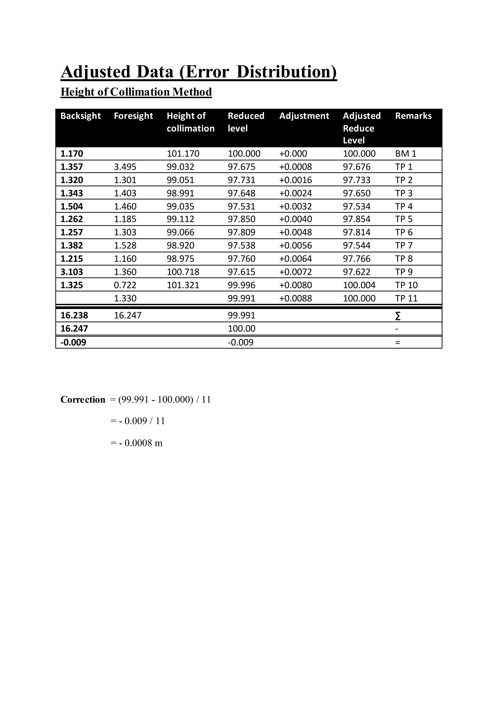
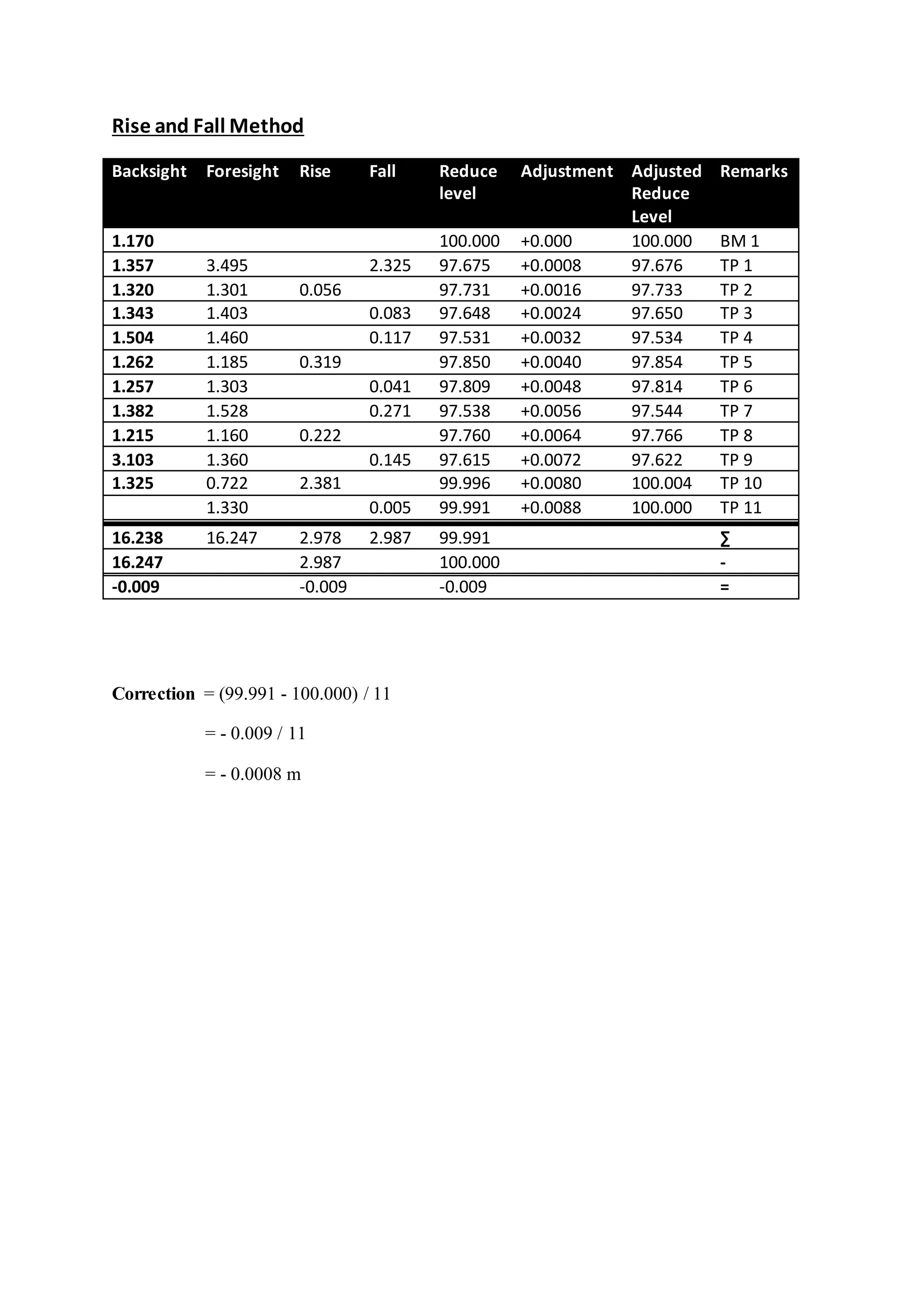
Levelling final

S
SCHOOL OF ARCHITECTURE • BUILDING • DESIGN
BACHELOR OF QUANTITY SURVEYING (HONOURS)
QSB 60103 – SITE SURVRYING
Fieldwork Report 1
Levelling
Name Student ID Marks
Yong Seen Yee 0315883
Yeoh Pooi Ching 0315540
Yee Algel 0315890
Yong Boon Xiong 0321754
Contents
Page
Introduction to Levelling ..........................................................................3
Objective.....................................................................................................6
Outline of Apparatus .................................................................................7
Levelling Results ..............................................................9
Adjusted Data (Error Distribution) ........................................................11
Discussion.................................................................................................13
Conclusion................................................................................................14
Reference ..................................................................................................15
Introduction to Levelling
Levelling is the process by which differences in height between two or more points
can be determined. Its purpose may be to provide heights or contours on a plan, to provide
data for road cross-sections or volumes of earthworks, or to provide a level or inclined
surface in the setting out of construction works. Levelling is the measurement
of geodetic height using an optical levelling instrument and a level staff or rod having a
numbered scale. Common levelling instruments include the spirit level, the dumpy level, the
digital level, and the laser level.
(Buildcivil,2013)
Definition
 Datum - This is an arbitrary level surface to which the heights of all points are
referred. This may be the National Datum (Australian Height Datum) or local datum
point established on a construction site.
 Mean sea level (MSL) - The average (mean) height of the sea between High and Low
tides
 Reduced Level (RL) - A distance recorded as a Height Above or below the datum.
This height is in metres
 Benchmark - A benchmark in everyday language is a point of reference for a
measurement. In surveying a benchmark is specifically any permanent marker placed
by a surveyor with a precisely known vertical elevation (but not necessarily a
precisely known horizontal location). Designed to be used for many projects.
 A Temporary benchmark (TBM) - Benchmark usually placed for a particular
project. Not designed to be a reference for other projects or for long term use.
Source: http://gmba-learning-gateway.co.uk/images/Height_of_Col.jpg?713
Source: http://gmba-learning-gateway.co.uk/images/Rise_Fall.jpg?713
(National Ocean Service, 2007)
 Back-sight - A sight taken to a benchmark or temporary benchmark. (first sight taken
after setting)
 Intermediate Sight - These are the sights taken at nominated position, known as
stations. The sights are then converted to reduced levels.
 Foresight - This is the last sight taken before the instrument is moved during a
traverse.
Objective
1. Find the elevation of a given point with respect to the given or assumed datum.
2. Establish a point at a given elevation with respect to the given or assumed datum.
3. To identify the spot relative height.
4. To identify possible errors occurred.
Outline of Apparatus
a) Automatic Level
- Used by land surveyor to establish points in the same horizontal plane. It is used in
surveying and building with a vertical staff to measure height differences and so
transfer, measure and set heights.
- The automatic level is set above a tripod accurately to a leveled condition using
footscrews.
(Ebay,n.d.)
b) Levelling rod
- A graduated wooden or alluminium rod, used with a levelling instrument to
determine the difference in height between points above a datum surface.
(JimTrade.com, n.d.)
c) Adjustable leg- tripod
- Surveyor’s tripod is a device used to support any one of a number of surveying
instruments, such as automatic level.
- This tripods are more common in the construction world, especially outdoors
because of generally uneven surfaces.
(Ebay,n.d.)
d) Spirit Level
- An instrument designed to indicate whether a surface is horizontal or vertical.
Used in different type of instruments carry by surveyors.
(leveldevelopments, n.d.)
Levelling Results
Height of Collimation Method
Backsight Foresight Height of
collimation
Reduced level Remarks
1.170 101.170 100.000 BM 1
1.357 3.495 99.032 97.675 TP 1
1.320 1.301 99.051 97.731 TP 2
1.343 1.403 98.991 97.648 TP 3
1.504 1.460 99.035 97.531 TP 4
1.262 1.185 99.112 97.850 TP 5
1.257 1.303 99.066 97.809 TP 6
1.382 1.528 98.920 97.538 TP 7
1.215 1.160 98.975 97.760 TP 8
3.103 1.360 100.718 97.615 TP 9
1.325 0.722 101.321 99.996 TP 10
1.330 99.991 TP 11
16.238 16.247 99.991 ∑
16.247 100.00 -
-0.009 -0.009 =
Arithmetical check:
∑BS - ∑FS = Last reduce level – First reduce level
16.238 – 16.247 = 99.991 – 100.000
-0.009 = -0.009
Maximum allowable error of closure, mm: +/- 12 √K
K = Number of set-ups
+/- 12 √11 = +/- 39.799 mm
Hence, the levelling is acceptable.
Rise and FallMethod
Backsight Foresight Rise Fall Reduce
level
Remarks
1.170 100.000 BM 1
1.357 3.495 2.325 97.675 TP 1
1.320 1.301 0.056 97.731 TP 2
1.343 1.403 0.083 97.648 TP 3
1.504 1.460 0.117 97.531 TP 4
1.262 1.185 0.319 97.850 TP 5
1.257 1.303 0.041 97.809 TP 6
1.382 1.528 0.271 97.538 TP 7
1.215 1.160 0.222 97.760 TP 8
3.103 1.360 0.145 97.615 TP 9
1.325 0.722 2.381 99.996 TP 10
1.330 0.005 99.991 TP 11
16.238 16.247 2.978 2.987 99.991 ∑
16.247 2.987 100.000 -
-0.009 -0.009 -0.009 =
Arithmetical check:
∑BS - ∑FS = ∑R - ∑L = Last reduce level – First reduce level
16.238 – 16.247 = 2.978 – 2.987 = 99.991 – 100.000
-0.009 = -0.009 = -0.009
Maximum allowable error of closure, mm: +/- 12 √K
K = Number of set-ups
+/- 12 √11 = +/- 39.799 mm
Hence, the levelling is acceptable.
Adjusted Data (Error Distribution)
Height of Collimation Method
Backsight Foresight Height of
collimation
Reduced
level
Adjustment Adjusted
Reduce
Level
Remarks
1.170 101.170 100.000 +0.000 100.000 BM 1
1.357 3.495 99.032 97.675 +0.0008 97.676 TP 1
1.320 1.301 99.051 97.731 +0.0016 97.733 TP 2
1.343 1.403 98.991 97.648 +0.0024 97.650 TP 3
1.504 1.460 99.035 97.531 +0.0032 97.534 TP 4
1.262 1.185 99.112 97.850 +0.0040 97.854 TP 5
1.257 1.303 99.066 97.809 +0.0048 97.814 TP 6
1.382 1.528 98.920 97.538 +0.0056 97.544 TP 7
1.215 1.160 98.975 97.760 +0.0064 97.766 TP 8
3.103 1.360 100.718 97.615 +0.0072 97.622 TP 9
1.325 0.722 101.321 99.996 +0.0080 100.004 TP 10
1.330 99.991 +0.0088 100.000 TP 11
16.238 16.247 99.991 ∑
16.247 100.00 -
-0.009 -0.009 =
Correction = (99.991 - 100.000) / 11
= - 0.009 / 11
= - 0.0008 m
Rise and Fall Method
Backsight Foresight Rise Fall Reduce
level
Adjustment Adjusted
Reduce
Level
Remarks
1.170 100.000 +0.000 100.000 BM 1
1.357 3.495 2.325 97.675 +0.0008 97.676 TP 1
1.320 1.301 0.056 97.731 +0.0016 97.733 TP 2
1.343 1.403 0.083 97.648 +0.0024 97.650 TP 3
1.504 1.460 0.117 97.531 +0.0032 97.534 TP 4
1.262 1.185 0.319 97.850 +0.0040 97.854 TP 5
1.257 1.303 0.041 97.809 +0.0048 97.814 TP 6
1.382 1.528 0.271 97.538 +0.0056 97.544 TP 7
1.215 1.160 0.222 97.760 +0.0064 97.766 TP 8
3.103 1.360 0.145 97.615 +0.0072 97.622 TP 9
1.325 0.722 2.381 99.996 +0.0080 100.004 TP 10
1.330 0.005 99.991 +0.0088 100.000 TP 11
16.238 16.247 2.978 2.987 99.991 ∑
16.247 2.987 100.000 -
-0.009 -0.009 -0.009 =
Correction = (99.991 - 100.000) / 11
= - 0.009 / 11
= - 0.0008 m
Discussion
In this field work, the reduce level of the Bench Mark (BM) 1 is given which is
100.000m. Therefore, the reading of the backsight (BS) and the reading of the foresight (FS)
are measured and recorded through the levelling process. This process is repeated for 10
times by shifting the auto level from one point to another point at the site.
After obtaining the field data, we used both methods which are the height of
collimation method and rise and fall method to calculate the reduce level of each station. For
rise and fall method, the sum of the back-sights minus the sum of the foresights is equal to
the sum of the rises minus the sum of the falls, and is also equal to the last reduced level
minus the first reduce level. While for the height of collimation method, the sum of the back-
sights minus the sum of the foresights is equal to the last reduce level minus the first reduce
level.
However, in this data, the final reduce level is less than the initial reduce level. Thus,
there are some of the errors occurred during the levelling process. In this case, we can use
error distribution method to adjust the reduce level result.
After we calculated the reading, the error of disclosure is -0.0008 and the maximum
allowable error of closure is +/- 39.799mm. Thus, our levelling is acceptable.
To distribute the error, the correction is calculated according to the number of the
instrument setups. The correction per setup is +0.0008 and is shown in the table provided in
the adjusted data section.
Conclusion
In conclusion, we manage to obtain the data needed by using the leveling equipment
provided by our lecturer. We did this fieldwork twice because the error of misclosure in our
first set of data was too large. Hence, we had decided to redo this fieldwork. Even though we
had to spend more time, but in the end we managed to obtain a set of data with acceptable
range of error of misclosure.
After identifying the errors are in an acceptable range, we did adjustments to the data
obtained by distributing the errors. We used both rise and fall method and height of
collimation method to calculate the reduced level of each staff station. Then, we are able to
complete our fieldwork report with this complete set of data.
Reference
1.) Levelling and surveying. (n.d.). Levelling and surveying. (Website) Retrieved from
http://moodle.najah.edu/pluginfile.php/47165/mod_resource/content/0/Levelling_2.pdf3
2.) Manchester 1824. (n.d.). Surveying: Using a level. (Website) Retrieve from
http://media.humanities.manchester.ac.uk/humanities/flash/HumeL046_FionaSmyth_SED_2/
surveying/surveying.html
3.) Engineersupply. (n.d.). automatic levels. (Website) Retrieved from
http://www.engineersupply.com/automatic-levels.aspx
4.) Dictionary of Construction.com. (n.d.). Leveling rod. (Website) Retrieved from
http://www.dictionaryofconstruction.com/definition/leveling-rod.html
5.) Environmental Field Techniques. (n.d.). Surveying 1: Differential Leveling. (Website)
Retrieved from http://www.colorado.edu/geography/courses/geog_2043_f01/lab01_4.html
6.) Encyclopaedia Britannica. (n.d.). Spirit Leval. (Website) Retrieved from
http://global.britannica.com/technology/spirit-level

More Related Content

What's hot

Site surveying report1Site surveying report1
Site surveying report1Est
2K views16 slides
Leveling final-reportLeveling final-report
Leveling final-reportFelix Vong
71.6K views19 slides
Earthwork notesEarthwork notes
Earthwork notesAdilen Del
11.3K views47 slides

What's hot(20)

Site Surveying Levelling Site Surveying Levelling
Site Surveying Levelling
Darren Lee4.4K views
Triangulation surveyTriangulation survey
Triangulation survey
HastarajPandey9.6K views
Site surveying report1Site surveying report1
Site surveying report1
Est 2K views
Leveling final-reportLeveling final-report
Leveling final-report
Felix Vong71.6K views
Earthwork notesEarthwork notes
Earthwork notes
Adilen Del11.3K views
Assignment 2 - TraverseAssignment 2 - Traverse
Assignment 2 - Traverse
Kai Yun Pang15.5K views
LevellingLevelling
Levelling
Arissa Loh 51.9K views
CurvesCurves
Curves
SRIKANTH SAMUDRALA23.1K views
Setting out workSetting out work
Setting out work
Shivam Mehta27.1K views
Tranverse report Tranverse report
Tranverse report
Wen Crystal2.6K views
Road construction in Civil engineeringRoad construction in Civil engineering
Road construction in Civil engineering
Kailash Chander3.5K views
Topic 3   mass haul diagramTopic 3   mass haul diagram
Topic 3 mass haul diagram
kmasz kamal103.1K views
engineering survey 1 report levellingengineering survey 1 report levelling
engineering survey 1 report levelling
YASMINE HASLAN43.2K views
Fieldwork 2 (Traversing)Fieldwork 2 (Traversing)
Fieldwork 2 (Traversing)
Enoch Wong6.1K views
Levelling report-1Levelling report-1
Levelling report-1
tfkc121211.5K views

Viewers also liked

levelling surveylevelling survey
levelling surveyprashantsingham
21.4K views23 slides
Engineering surveying-iiEngineering surveying-ii
Engineering surveying-iiMarvin Ken
161.6K views73 slides
LevellingLevelling
LevellingGAURAV. H .TANDON
266.3K views141 slides
LevellingLevelling
LevellingKrushal Kakadia
3.1K views18 slides

Viewers also liked(20)

levelling surveylevelling survey
levelling survey
prashantsingham21.4K views
Engineering surveying-iiEngineering surveying-ii
Engineering surveying-ii
Marvin Ken161.6K views
LevellingLevelling
Levelling
GAURAV. H .TANDON266.3K views
6 dumpy levels. example of use6 dumpy levels. example of use
6 dumpy levels. example of use
vigyanashram95.2K views
LevellingLevelling
Levelling
Krushal Kakadia3.1K views
Ss report 1Ss report 1
Ss report 1
Hasif Alias997 views
Site report for Measurement 1Site report for Measurement 1
Site report for Measurement 1
Yap Xin1.2K views
Ss report 1Ss report 1
Ss report 1
chloeesim1.7K views
Site Surveying report2 traversingSite Surveying report2 traversing
Site Surveying report2 traversing
KhangWei Chin355 views
Unified training-part-aUnified training-part-a
Unified training-part-a
Zakee Kazmee1K views
Project 1- Levelling Project 1- Levelling
Project 1- Levelling
seenyee4.6K views
Site Surveying Fieldwork 2Site Surveying Fieldwork 2
Site Surveying Fieldwork 2
Yap Xin2.2K views
LevellingLevelling
Levelling
Diana Dian4.1K views
Booking sheets, 2011 v1Booking sheets, 2011 v1
Booking sheets, 2011 v1
jbusse14.4K views
LevellingLevelling
Levelling
Pralhad Kore5.5K views
Levelling in SurveyingLevelling in Surveying
Levelling in Surveying
RAHUL SINHA61.3K views

Similar to Levelling final

Ss report 1Ss report 1
Ss report 1Shen Sin
158 views15 slides
Site surveying report 1Site surveying report 1
Site surveying report 1Doreen Yeo
2.6K views16 slides
Site surveying report 2Site surveying report 2
Site surveying report 2Doreen Yeo
2.1K views17 slides

Similar to Levelling final(20)

Ss report 1Ss report 1
Ss report 1
Shen Sin158 views
Site survey report 1Site survey report 1
Site survey report 1
Orlando Wong Khung934 views
Fieldwork 1 (leveling)Fieldwork 1 (leveling)
Fieldwork 1 (leveling)
Enoch Wong1.7K views
Site surveying report 1Site surveying report 1
Site surveying report 1
Doreen Yeo2.6K views
Ss report 1 ----levelling eportSs report 1 ----levelling eport
Ss report 1 ----levelling eport
MELVIN tan392 views
Site surveying report 2Site surveying report 2
Site surveying report 2
Doreen Yeo2.1K views
Ss report1Ss report1
Ss report1
KhangWei Chin245 views
Ss report 1Ss report 1
Ss report 1
Pang Shuen1K views
2. Practical assessment Carry out Levelling Operations2. Practical assessment Carry out Levelling Operations
2. Practical assessment Carry out Levelling Operations
Canberra Institute of technology2.2K views
Site surveying-report-2Site surveying-report-2
Site surveying-report-2
Shane Ah1.8K views
Site surveying report 2Site surveying report 2
Site surveying report 2
Tee Joanne623 views
Site Surveying TraversingSite Surveying Traversing
Site Surveying Traversing
Darren Lee5.5K views
Fieldwork 1 Fieldwork 1
Fieldwork 1
JamesMoy7405 views
Fieldwork 1Fieldwork 1
Fieldwork 1
Melvin Lim581 views
Practical assessment 2- Carry out LevellingPractical assessment 2- Carry out Levelling
Practical assessment 2- Carry out Levelling
Canberra Institute of technology618 views
Ge 105 lecture 1 (LEAST SQUARES ADJUSTMENT) by: Broddett B. AbatayoGe 105 lecture 1 (LEAST SQUARES ADJUSTMENT) by: Broddett B. Abatayo
Ge 105 lecture 1 (LEAST SQUARES ADJUSTMENT) by: Broddett B. Abatayo
BPA ABATAYO Land Surveying Services37.1K views
1. Practical assessment-Carry out levelling operations1. Practical assessment-Carry out levelling operations
1. Practical assessment-Carry out levelling operations
Canberra Institute of technology2.4K views
Site surveying report 1Site surveying report 1
Site surveying report 1
Tee Joanne1.1K views

Levelling final

  • 1. SCHOOL OF ARCHITECTURE • BUILDING • DESIGN BACHELOR OF QUANTITY SURVEYING (HONOURS) QSB 60103 – SITE SURVRYING Fieldwork Report 1 Levelling Name Student ID Marks Yong Seen Yee 0315883 Yeoh Pooi Ching 0315540 Yee Algel 0315890 Yong Boon Xiong 0321754
  • 2. Contents Page Introduction to Levelling ..........................................................................3 Objective.....................................................................................................6 Outline of Apparatus .................................................................................7 Levelling Results ..............................................................9 Adjusted Data (Error Distribution) ........................................................11 Discussion.................................................................................................13 Conclusion................................................................................................14 Reference ..................................................................................................15
  • 3. Introduction to Levelling Levelling is the process by which differences in height between two or more points can be determined. Its purpose may be to provide heights or contours on a plan, to provide data for road cross-sections or volumes of earthworks, or to provide a level or inclined surface in the setting out of construction works. Levelling is the measurement of geodetic height using an optical levelling instrument and a level staff or rod having a numbered scale. Common levelling instruments include the spirit level, the dumpy level, the digital level, and the laser level. (Buildcivil,2013) Definition  Datum - This is an arbitrary level surface to which the heights of all points are referred. This may be the National Datum (Australian Height Datum) or local datum point established on a construction site.  Mean sea level (MSL) - The average (mean) height of the sea between High and Low tides  Reduced Level (RL) - A distance recorded as a Height Above or below the datum. This height is in metres  Benchmark - A benchmark in everyday language is a point of reference for a measurement. In surveying a benchmark is specifically any permanent marker placed by a surveyor with a precisely known vertical elevation (but not necessarily a precisely known horizontal location). Designed to be used for many projects.  A Temporary benchmark (TBM) - Benchmark usually placed for a particular project. Not designed to be a reference for other projects or for long term use.
  • 5. (National Ocean Service, 2007)  Back-sight - A sight taken to a benchmark or temporary benchmark. (first sight taken after setting)  Intermediate Sight - These are the sights taken at nominated position, known as stations. The sights are then converted to reduced levels.  Foresight - This is the last sight taken before the instrument is moved during a traverse.
  • 6. Objective 1. Find the elevation of a given point with respect to the given or assumed datum. 2. Establish a point at a given elevation with respect to the given or assumed datum. 3. To identify the spot relative height. 4. To identify possible errors occurred.
  • 7. Outline of Apparatus a) Automatic Level - Used by land surveyor to establish points in the same horizontal plane. It is used in surveying and building with a vertical staff to measure height differences and so transfer, measure and set heights. - The automatic level is set above a tripod accurately to a leveled condition using footscrews. (Ebay,n.d.) b) Levelling rod - A graduated wooden or alluminium rod, used with a levelling instrument to determine the difference in height between points above a datum surface. (JimTrade.com, n.d.)
  • 8. c) Adjustable leg- tripod - Surveyor’s tripod is a device used to support any one of a number of surveying instruments, such as automatic level. - This tripods are more common in the construction world, especially outdoors because of generally uneven surfaces. (Ebay,n.d.) d) Spirit Level - An instrument designed to indicate whether a surface is horizontal or vertical. Used in different type of instruments carry by surveyors. (leveldevelopments, n.d.)
  • 9. Levelling Results Height of Collimation Method Backsight Foresight Height of collimation Reduced level Remarks 1.170 101.170 100.000 BM 1 1.357 3.495 99.032 97.675 TP 1 1.320 1.301 99.051 97.731 TP 2 1.343 1.403 98.991 97.648 TP 3 1.504 1.460 99.035 97.531 TP 4 1.262 1.185 99.112 97.850 TP 5 1.257 1.303 99.066 97.809 TP 6 1.382 1.528 98.920 97.538 TP 7 1.215 1.160 98.975 97.760 TP 8 3.103 1.360 100.718 97.615 TP 9 1.325 0.722 101.321 99.996 TP 10 1.330 99.991 TP 11 16.238 16.247 99.991 ∑ 16.247 100.00 - -0.009 -0.009 = Arithmetical check: ∑BS - ∑FS = Last reduce level – First reduce level 16.238 – 16.247 = 99.991 – 100.000 -0.009 = -0.009 Maximum allowable error of closure, mm: +/- 12 √K K = Number of set-ups +/- 12 √11 = +/- 39.799 mm Hence, the levelling is acceptable.
  • 10. Rise and FallMethod Backsight Foresight Rise Fall Reduce level Remarks 1.170 100.000 BM 1 1.357 3.495 2.325 97.675 TP 1 1.320 1.301 0.056 97.731 TP 2 1.343 1.403 0.083 97.648 TP 3 1.504 1.460 0.117 97.531 TP 4 1.262 1.185 0.319 97.850 TP 5 1.257 1.303 0.041 97.809 TP 6 1.382 1.528 0.271 97.538 TP 7 1.215 1.160 0.222 97.760 TP 8 3.103 1.360 0.145 97.615 TP 9 1.325 0.722 2.381 99.996 TP 10 1.330 0.005 99.991 TP 11 16.238 16.247 2.978 2.987 99.991 ∑ 16.247 2.987 100.000 - -0.009 -0.009 -0.009 = Arithmetical check: ∑BS - ∑FS = ∑R - ∑L = Last reduce level – First reduce level 16.238 – 16.247 = 2.978 – 2.987 = 99.991 – 100.000 -0.009 = -0.009 = -0.009 Maximum allowable error of closure, mm: +/- 12 √K K = Number of set-ups +/- 12 √11 = +/- 39.799 mm Hence, the levelling is acceptable.
  • 11. Adjusted Data (Error Distribution) Height of Collimation Method Backsight Foresight Height of collimation Reduced level Adjustment Adjusted Reduce Level Remarks 1.170 101.170 100.000 +0.000 100.000 BM 1 1.357 3.495 99.032 97.675 +0.0008 97.676 TP 1 1.320 1.301 99.051 97.731 +0.0016 97.733 TP 2 1.343 1.403 98.991 97.648 +0.0024 97.650 TP 3 1.504 1.460 99.035 97.531 +0.0032 97.534 TP 4 1.262 1.185 99.112 97.850 +0.0040 97.854 TP 5 1.257 1.303 99.066 97.809 +0.0048 97.814 TP 6 1.382 1.528 98.920 97.538 +0.0056 97.544 TP 7 1.215 1.160 98.975 97.760 +0.0064 97.766 TP 8 3.103 1.360 100.718 97.615 +0.0072 97.622 TP 9 1.325 0.722 101.321 99.996 +0.0080 100.004 TP 10 1.330 99.991 +0.0088 100.000 TP 11 16.238 16.247 99.991 ∑ 16.247 100.00 - -0.009 -0.009 = Correction = (99.991 - 100.000) / 11 = - 0.009 / 11 = - 0.0008 m
  • 12. Rise and Fall Method Backsight Foresight Rise Fall Reduce level Adjustment Adjusted Reduce Level Remarks 1.170 100.000 +0.000 100.000 BM 1 1.357 3.495 2.325 97.675 +0.0008 97.676 TP 1 1.320 1.301 0.056 97.731 +0.0016 97.733 TP 2 1.343 1.403 0.083 97.648 +0.0024 97.650 TP 3 1.504 1.460 0.117 97.531 +0.0032 97.534 TP 4 1.262 1.185 0.319 97.850 +0.0040 97.854 TP 5 1.257 1.303 0.041 97.809 +0.0048 97.814 TP 6 1.382 1.528 0.271 97.538 +0.0056 97.544 TP 7 1.215 1.160 0.222 97.760 +0.0064 97.766 TP 8 3.103 1.360 0.145 97.615 +0.0072 97.622 TP 9 1.325 0.722 2.381 99.996 +0.0080 100.004 TP 10 1.330 0.005 99.991 +0.0088 100.000 TP 11 16.238 16.247 2.978 2.987 99.991 ∑ 16.247 2.987 100.000 - -0.009 -0.009 -0.009 = Correction = (99.991 - 100.000) / 11 = - 0.009 / 11 = - 0.0008 m
  • 13. Discussion In this field work, the reduce level of the Bench Mark (BM) 1 is given which is 100.000m. Therefore, the reading of the backsight (BS) and the reading of the foresight (FS) are measured and recorded through the levelling process. This process is repeated for 10 times by shifting the auto level from one point to another point at the site. After obtaining the field data, we used both methods which are the height of collimation method and rise and fall method to calculate the reduce level of each station. For rise and fall method, the sum of the back-sights minus the sum of the foresights is equal to the sum of the rises minus the sum of the falls, and is also equal to the last reduced level minus the first reduce level. While for the height of collimation method, the sum of the back- sights minus the sum of the foresights is equal to the last reduce level minus the first reduce level. However, in this data, the final reduce level is less than the initial reduce level. Thus, there are some of the errors occurred during the levelling process. In this case, we can use error distribution method to adjust the reduce level result. After we calculated the reading, the error of disclosure is -0.0008 and the maximum allowable error of closure is +/- 39.799mm. Thus, our levelling is acceptable. To distribute the error, the correction is calculated according to the number of the instrument setups. The correction per setup is +0.0008 and is shown in the table provided in the adjusted data section.
  • 14. Conclusion In conclusion, we manage to obtain the data needed by using the leveling equipment provided by our lecturer. We did this fieldwork twice because the error of misclosure in our first set of data was too large. Hence, we had decided to redo this fieldwork. Even though we had to spend more time, but in the end we managed to obtain a set of data with acceptable range of error of misclosure. After identifying the errors are in an acceptable range, we did adjustments to the data obtained by distributing the errors. We used both rise and fall method and height of collimation method to calculate the reduced level of each staff station. Then, we are able to complete our fieldwork report with this complete set of data.
  • 15. Reference 1.) Levelling and surveying. (n.d.). Levelling and surveying. (Website) Retrieved from http://moodle.najah.edu/pluginfile.php/47165/mod_resource/content/0/Levelling_2.pdf3 2.) Manchester 1824. (n.d.). Surveying: Using a level. (Website) Retrieve from http://media.humanities.manchester.ac.uk/humanities/flash/HumeL046_FionaSmyth_SED_2/ surveying/surveying.html 3.) Engineersupply. (n.d.). automatic levels. (Website) Retrieved from http://www.engineersupply.com/automatic-levels.aspx 4.) Dictionary of Construction.com. (n.d.). Leveling rod. (Website) Retrieved from http://www.dictionaryofconstruction.com/definition/leveling-rod.html 5.) Environmental Field Techniques. (n.d.). Surveying 1: Differential Leveling. (Website) Retrieved from http://www.colorado.edu/geography/courses/geog_2043_f01/lab01_4.html 6.) Encyclopaedia Britannica. (n.d.). Spirit Leval. (Website) Retrieved from http://global.britannica.com/technology/spirit-level