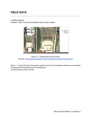
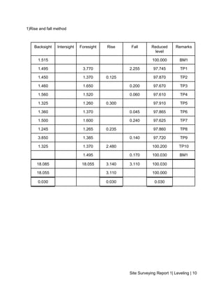
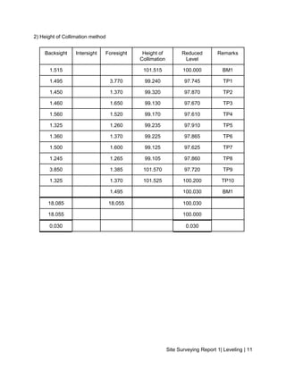
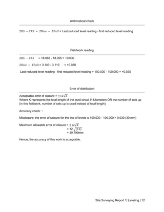
SlideShare a Scribd company logo
1 of 15
Download to read offline
.
SCHOOL OF ARCHITECTURE, BUILDING AND DESIGN
BACHELOR OF QUANTITY SURVEYING (HONOURS)
QSB60103 - SITE SURVEYING
Field Work 1 Report
Leveling
NAME STUDENT ID MARKS
Yap Foong Mei 0324867
Yeo Gin Faye 0330001
Teow Kah Yan 0327201
Tan Shen Sin 0324602
Tan Yong Chien 0320200
Site Surveying Report 1| Leveling | 2
TABLE CONTENT
CONTENT PAGE
Cover Page 1
Table Content 2
Introduction to Leveling 3-7
Objective 8
Field Data 9-12
Adjusted Data 13
Summary 14-15
Site Surveying Report 1| Leveling | 3
INTRODUCTION TO LEVELLING
Leveling is a branch of surveying, the object of which is to find the elevations of given
points with respect to a given or assumed datum and to establish points at a given or assumed
datum. (Punmia,2015).
Basically, there are few methods of levelling to determine the elevations of points and to
measure vertical distance of the station. These methods include barometric levelling,
trigonometric levelling and spirit levelling. In this fieldwork, we are using spirit levelling method.
It is the most common levelling method so far.
In other words, levelling is a survey carried out to find the reduced level of a station that
has been set. There are two methods is calculating the reduced level of the stations, which are
the rise and fall method and the height of collimation method. Both method had been used to
calculate out the reduced level of the point in this fieldwork.
Figure 1.0: Example of the working of levelling
Source: http://www.colorado.edu/geography/courses/geog_2043_f01/lab01_4.html
Site Surveying Report 1| Leveling | 4
The figure above shows an example of traverse with a turning point. Basically, levelling
works in this way. First the auto-level is set up at Station A and backsight is taken to benchmark
where elevation of 100.00m is given. As the rod reading of 2.45 metres is taken, the height of
collimation would be 100.00 m + 2.45 m = 102.45 m. Then, foresight is taken to another point
and the rod reading showed 0.60 m and therefore the elevation of the point will be 102.45 m -
0.60 m = 101.85 m. Next, the auto-level will be shifted to Station B with the rod maintained at
the same point and thus that particular point is known as turning point (TP). Backsight is then
taken to the turning point with the rod reading of 1.70 m and thus the height of collimation at
Station B is 101.85 m + 1.70 m = 103.55m.
The instruments used in levelling are the automatic level which used to demand
accurate levelling, the tripod stand which ensure a stable setup for instrument, the optical
plummet that used to centre the instruments over a ground station, the leveling rod used to
measure the elevation measurement of a station and a spirit bubble to ensure that the
instrument is levelled and is in a vertical position to ensure accurate measurement is taken.
Figure 1.1 : Automatic Level
Source : http://www.forestry-suppliers.com/product_pages/Products.asp?mi=75631
Site Surveying Report 1| Leveling | 5
Figure 1.2: Adjustable Leg Tripod
Source: http://www.nedo.com/index.pl?Lang=ENGLISH&Page=products/stative/holzstative.html
Figure 1.3: Optical Plummet
Source: http://www.nedo.com/index.pl?Lang=ENGLISH&Page=products/stative/holzstative.html
Site Surveying Report 1| Leveling | 6
Figure 1.4: Levelling Rod
Source: https://www.slideshare.net/felixvong/leveling-finalreport
Definition of terms used in Leveling
Level Surface:
A level surface is known as a curved surface which each point have right angles to the direction
of gravity of the earth.
Datum:
Datum is the surface to which elevations are referred. The mean sea level allows a convenient
datum world over, and elevations are gives as so much below or above sea level.
Site Surveying Report 1| Leveling | 7
Reduced Level:
Reduced level is the vertical distance measured below or above the mean sea level or
benchmark.
The line of Collimation:
The line of collimation is also known as horizontal line of sight. It passed through the optical
centre of the telescope of the level. The height of line of collimation above the datum is called
height of collimation.
Benchmark (BM):
Benchmark is a fixed point of reference with known elevation. It is used as a starting point and
as a point upon which to close as a check in levelling.
Temporary Benchmark:
A temporary benchmark is a fixed point with a known elevation which is set up by surveyor for
his own use during construction works and surveys.
Backsight (BS):
Backsight is the first staff reading taken after the setting up and levelling of the instrument.
Intermediate Sight (IS):
Intermediate sight is the sight or staff reading taken between a backsight and a foresight.
Foresight (FS):
Foresight is the last sight or staff reading taken during levelling operations before the shifting of
the instrument.
Turning point (TP):
Turning point also known as change point which is a point where the backsight and foresight
readings are taken. A turning point is enable the levelling to continue from a new instrument
position.
Station:
Station is a point to determine the elevation. It also can be noted as the point where the staff is
held.
Site Surveying Report 1| Leveling | 8
OBJECTIVES
1) To allow students to apply theories learnt into fieldwork
2) To allow students to have hands on experience in using levelling instruments
3) To foster teamwork between students
4) To enhance student’s knowledge in taking the reading and the correct method in
recording the reading
5) To expose students with the problem that they might face when using the instruments
and also it’s solutions
6) To expose students with the correct way and the precautions of using the levelling
instruments
7) To identify the reduced level of each station
8) To determine the error of distribution to have adjustment in levelling
9) To enhance student’s skills in site measurements and calculations in proper equation
table
Site Surveying Report 1| Leveling | 9
FIELD DATA
Levelling fieldwork
Location: Taylor’s University Lakeside Campus open carpark
Figure 1.1: Carpark plan and the points
Sources: http://dearasis.blogspot.my/2010/02/taylors-lakeside-campus.html
Figure 1.1 shows the plan of the open carpark and also the checkpoints where we are required
to measure the reduced level of the checkpoints.
The benchmark is set at 100.00.
Site Surveying Report 1| Leveling | 10
1)Rise and fall method
Backsight Intersight Foresight Rise Fall Reduced
level
Remarks
1.515 100.000 BM1
1.495 3.770 2.255 97.745 TP1
1.450 1.370 0.125 97.870 TP2
1.460 1.650 0.200 97.670 TP3
1.560 1.520 0.060 97.610 TP4
1.325 1.260 0.300 97.910 TP5
1.360 1.370 0.045 97.865 TP6
1.500 1.600 0.240 97.625 TP7
1.245 1.265 0.235 97.860 TP8
3.850 1.385 0.140 97.720 TP9
1.325 1.370 2.480 100.200 TP10
1.495 0.170 100.030 BM1
18.085 18.055 3.140 3.110 100.030
18.055 3.110 100.000
0.030 0.030 0.030
Site Surveying Report 1| Leveling | 11
2) Height of Collimation method
Backsight Intersight Foresight Height of
Collimation
Reduced
Level
Remarks
1.515 101.515 100.000 BM1
1.495 3.770 99.240 97.745 TP1
1.450 1.370 99.320 97.870 TP2
1.460 1.650 99.130 97.670 TP3
1.560 1.520 99.170 97.610 TP4
1.325 1.260 99.235 97.910 TP5
1.360 1.370 99.225 97.865 TP6
1.500 1.600 99.125 97.625 TP7
1.245 1.265 99.105 97.860 TP8
3.850 1.385 101.570 97.720 TP9
1.325 1.370 101.525 100.200 TP10
1.495 100.030 BM1
18.085 18.055 100.030
18.055 100.000
0.030 0.030
Site Surveying Report 1| Leveling | 12
Arithmetical check
𝛴𝐵𝑆 − 𝛴𝐹𝑆 = 𝛴𝑅𝑖𝑠𝑒 − 𝛴𝐹𝑎𝑙𝑙 = Last reduced level reading - first reduced level reading
Fieldwork reading
𝛴𝐵𝑆 − 𝛴𝐹𝑆 = 18.085 - 18.055 = +0.030
𝛴𝑅𝑖𝑠𝑒 − 𝛴𝐹𝑎𝑙𝑙 = 3.140 - 3.110 = +0.030
Last reduced level reading - first reduced level reading = 100.030 - 100.000 = +0.030
Error of distribution
Acceptable error of closure = ±12√𝐾
Where K represents the total length of the level circuit in kilometers OR the number of sets up
(in this fieldwork, number of sets up is used instead of total length)
Accuracy check: ~
Misclosure: the error of closure for the line of levels is 100.030 - 100.000 = 0.030 (30 mm)
Maximum allowable error of closure = ±12√𝐾
= 12 √(11)
= 39.799mm
Hence, the accuracy of this work is acceptable.
Site Surveying Report 1| Leveling | 13
ADJUSTED DATA
BS I
S
FS Rise Fall Height
Of
collimation
Reduce
level
Adjust Final
Reduced
Level
Remark
1.515 101.515 100.000 100.000 BM1
1.495 3.770 2.255 99.240 97.745 -0.0027 97.742 TP1
1.450 1.370 0.125 99.320 97.870 -0.0055 97.865 TP2
1.460 1.650 0.200 99.130 97.670 -0.0082 97.662 TP3
1.560 1.520 0.060 99.170 97.610 -0.0109 97.599 TP4
1.325 1.260 0.300 99.235 97.910 -0.0136 97.896 TP5
1.360 1.370 0.045 99.225 97.865 -0.0163 87.849 TP6
1.500 1.600 0.240 99.125 97.625 -0.0190 97.606 TP7
1.245 1.265 0.235 99.105 97.860 -0.0217 97.838 TP8
3.850 1.385 0.140 101.570 97.720 -0.0244 97.696 TP9
1.325 1.370 2.480 101.525 100.200 -0.0271 100.173 TP10
1.495 0.170 100.030 -0.0298 100.000 BM1
18.085 18.055 3.140 3.110 100.030
18.055 3.110 100.000
0.030 0.030 0.030
Correction by using distance = cumulative distance ÷ total distance × error
However, when distance is not given, correction by number of setup is used
Correction by number of set-up: Error of misclosure ÷ number of set-up
Correction by number of set-up: (100.000 - 100.030) ÷ 11 = -0.0027m
Site Surveying Report 1| Leveling | 14
SUMMARY
In this fieldwork, we as students are given a chance to have hands on experience in
using the levelling staffs, starting from taking the backsight (BS) reading of the benchmark
(BM1) where the height of elevation set at 100.000 to taking the foresight (FS) reading of the
next checkpoint. Then, the auto-level is shifted to take both backsight (BS) and foresight (FS)
reading. The fieldwork is done once the auto-level is shifted back to the initial starting point to
obtain the foresight (FS) reading of benchmark (BM1) in order to figure if there’s an error and to
calculate the error of misclosure.
After collecting all of the data, we used both rise and fall and height of collimation
method to calculate the reduced level of the turning points (TP). After obtaining the reduced
level for each station, we found out that there is an error of misclosure of 30 mm. According to
the third Accuracy Standards for Vertical Control Surveys, maximum allowable error of closure
is ±12√𝐾 and using the same standard, the maximum allowable error of closure for the data we
collected is 39.799mm, where K represents the number of setup as total length is not given in
this case. Hence, the accuracy of this fieldwork is acceptable. Thus, the reduced level of the
benchmark is made equivalent at 100.000 by distributing the error to each setup and by
adjusting it to the reduced level.
In conclusion, we gained experience through the hands-on experience. It is crucial for us
as a future quantity surveyor to have some knowledge in site surveying and this can ensure that
we can understand and communicate well with the land surveyors. Moreover, this fieldwork had
foster effective teamwork and collaboration between team members. Having good teamwork is
one of the essential element which employer will seek for and this will help a lot in our future
career.
Last but not least, special thanks to Mr Chai for giving us opportunities to have hands on
experience in using the levelling staffs and in guiding us throughout the project.
Site Surveying Report 1| Leveling | 15
Picture 1.0: Group photo
From left to right:
Teow Kah Yan, Yeo Gin Faye, Tan Shen Sin, Yap Foong Mei and Tan Yong Chien.

More Related Content

What's hot

Site Surveying Report 1 (Levelling)
Site Surveying Report 1 (Levelling)Site Surveying Report 1 (Levelling)
Site Surveying Report 1 (Levelling)Haziq1511
 
Ss report 2
Ss report 2Ss report 2
Ss report 2Shen Sin
 
Site surveying report 1
Site surveying report 1Site surveying report 1
Site surveying report 1Doreen Yeo
 
Site surveying-report-2
Site surveying-report-2Site surveying-report-2
Site surveying-report-2Shane Ah
 
Fieldwork 2
Fieldwork 2 Fieldwork 2
Fieldwork 2 JamesMoy7
 
Site Surveying Fieldwork 2
Site Surveying Fieldwork 2Site Surveying Fieldwork 2
Site Surveying Fieldwork 2Yap Xin
 
Site surveying report 1
Site surveying report 1Site surveying report 1
Site surveying report 1Tee Joanne
 
Fieldwork 2 (Traversing)
Fieldwork 2 (Traversing)Fieldwork 2 (Traversing)
Fieldwork 2 (Traversing)Enoch Wong
 
Tranverse report
Tranverse report Tranverse report
Tranverse report Wen Crystal
 
Project 2- traversing
Project 2- traversingProject 2- traversing
Project 2- traversingseenyee
 
Theodolite surveying part2
Theodolite surveying part2Theodolite surveying part2
Theodolite surveying part2Naufil Sayyad
 
S2 6 theodolites
S2 6 theodolitesS2 6 theodolites
S2 6 theodolitesEst
 
Site surveying-Leveling
Site surveying-LevelingSite surveying-Leveling
Site surveying-LevelingShane Ah
 
Theodolite surveying part 1 (I scheme MSBTE)
Theodolite surveying part 1 (I scheme MSBTE)Theodolite surveying part 1 (I scheme MSBTE)
Theodolite surveying part 1 (I scheme MSBTE)Naufil Sayyad
 
Site Surveying Levelling
Site Surveying Levelling Site Surveying Levelling
Site Surveying Levelling Darren Lee
 
Site Surveying Fieldwork 1
Site Surveying Fieldwork 1Site Surveying Fieldwork 1
Site Surveying Fieldwork 1Yap Xin
 

What's hot (19)

Site Surveying Report 1 (Levelling)
Site Surveying Report 1 (Levelling)Site Surveying Report 1 (Levelling)
Site Surveying Report 1 (Levelling)
 
Ss report 2
Ss report 2Ss report 2
Ss report 2
 
Site surveying report 1
Site surveying report 1Site surveying report 1
Site surveying report 1
 
Site surveying-report-2
Site surveying-report-2Site surveying-report-2
Site surveying-report-2
 
Ss report 1
Ss report 1Ss report 1
Ss report 1
 
Fieldwork 2
Fieldwork 2 Fieldwork 2
Fieldwork 2
 
Site Surveying Fieldwork 2
Site Surveying Fieldwork 2Site Surveying Fieldwork 2
Site Surveying Fieldwork 2
 
Levelling
LevellingLevelling
Levelling
 
Site surveying report 1
Site surveying report 1Site surveying report 1
Site surveying report 1
 
Fieldwork 2 (Traversing)
Fieldwork 2 (Traversing)Fieldwork 2 (Traversing)
Fieldwork 2 (Traversing)
 
Tranverse report
Tranverse report Tranverse report
Tranverse report
 
Project 2- traversing
Project 2- traversingProject 2- traversing
Project 2- traversing
 
Theodolite surveying part2
Theodolite surveying part2Theodolite surveying part2
Theodolite surveying part2
 
S2 6 theodolites
S2 6 theodolitesS2 6 theodolites
S2 6 theodolites
 
Site surveying-Leveling
Site surveying-LevelingSite surveying-Leveling
Site surveying-Leveling
 
surveying ii
surveying iisurveying ii
surveying ii
 
Theodolite surveying part 1 (I scheme MSBTE)
Theodolite surveying part 1 (I scheme MSBTE)Theodolite surveying part 1 (I scheme MSBTE)
Theodolite surveying part 1 (I scheme MSBTE)
 
Site Surveying Levelling
Site Surveying Levelling Site Surveying Levelling
Site Surveying Levelling
 
Site Surveying Fieldwork 1
Site Surveying Fieldwork 1Site Surveying Fieldwork 1
Site Surveying Fieldwork 1
 

Similar to Ss report 1

Ss report 1 ----levelling eport
Ss report 1 ----levelling eportSs report 1 ----levelling eport
Ss report 1 ----levelling eportMELVIN tan
 
Site surveying report1
Site surveying report1Site surveying report1
Site surveying report1Est
 
Assignment 1 - Levelling
Assignment 1 - LevellingAssignment 1 - Levelling
Assignment 1 - LevellingKai Yun Pang
 
Site survey Fieldwork1 (levelling)
Site survey Fieldwork1 (levelling)Site survey Fieldwork1 (levelling)
Site survey Fieldwork1 (levelling)Sheng Zhe
 
Levelling final
Levelling finalLevelling final
Levelling finalseenyee
 
Site survey Fieldwork 2 traversing
Site survey Fieldwork 2 traversingSite survey Fieldwork 2 traversing
Site survey Fieldwork 2 traversingSheng Zhe
 
ABC Report - 123 (gathered with reference)
ABC Report - 123 (gathered with reference)ABC Report - 123 (gathered with reference)
ABC Report - 123 (gathered with reference)Jing Chuang
 
SITE SURVEYING LEVELING
SITE SURVEYING LEVELINGSITE SURVEYING LEVELING
SITE SURVEYING LEVELINGFarah Sham
 
Advanced surveying equipment ppt
Advanced surveying equipment pptAdvanced surveying equipment ppt
Advanced surveying equipment pptNaufil Sayyad
 
Site Surveying Traversing
Site Surveying TraversingSite Surveying Traversing
Site Surveying TraversingDarren Lee
 
Fpt 3163 water_science_chapter_4_level_survey
Fpt 3163 water_science_chapter_4_level_surveyFpt 3163 water_science_chapter_4_level_survey
Fpt 3163 water_science_chapter_4_level_surveyRione Drevale
 
Assignment 2 - Traverse
Assignment 2 - TraverseAssignment 2 - Traverse
Assignment 2 - TraverseKai Yun Pang
 
GNSS and Total Station Survey
GNSS and Total Station SurveyGNSS and Total Station Survey
GNSS and Total Station Surveynihal navin
 

Similar to Ss report 1 (20)

Ss report 1 ----levelling eport
Ss report 1 ----levelling eportSs report 1 ----levelling eport
Ss report 1 ----levelling eport
 
Site surveying report1
Site surveying report1Site surveying report1
Site surveying report1
 
Ss report 1
Ss report 1Ss report 1
Ss report 1
 
Assignment 1 - Levelling
Assignment 1 - LevellingAssignment 1 - Levelling
Assignment 1 - Levelling
 
Site survey Fieldwork1 (levelling)
Site survey Fieldwork1 (levelling)Site survey Fieldwork1 (levelling)
Site survey Fieldwork1 (levelling)
 
Levelling final
Levelling finalLevelling final
Levelling final
 
Leveling report
Leveling reportLeveling report
Leveling report
 
Traversing
TraversingTraversing
Traversing
 
Site survey Fieldwork 2 traversing
Site survey Fieldwork 2 traversingSite survey Fieldwork 2 traversing
Site survey Fieldwork 2 traversing
 
Ss report 1
Ss report 1Ss report 1
Ss report 1
 
ABC Report - 123 (gathered with reference)
ABC Report - 123 (gathered with reference)ABC Report - 123 (gathered with reference)
ABC Report - 123 (gathered with reference)
 
SITE SURVEYING LEVELING
SITE SURVEYING LEVELINGSITE SURVEYING LEVELING
SITE SURVEYING LEVELING
 
Advanced surveying equipment ppt
Advanced surveying equipment pptAdvanced surveying equipment ppt
Advanced surveying equipment ppt
 
Site Surveying Traversing
Site Surveying TraversingSite Surveying Traversing
Site Surveying Traversing
 
Site surveying
Site surveying Site surveying
Site surveying
 
Fpt 3163 water_science_chapter_4_level_survey
Fpt 3163 water_science_chapter_4_level_surveyFpt 3163 water_science_chapter_4_level_survey
Fpt 3163 water_science_chapter_4_level_survey
 
Fieldwork 2
Fieldwork 2 Fieldwork 2
Fieldwork 2
 
Assignment 2 - Traverse
Assignment 2 - TraverseAssignment 2 - Traverse
Assignment 2 - Traverse
 
Survey work presentation
Survey work presentationSurvey work presentation
Survey work presentation
 
GNSS and Total Station Survey
GNSS and Total Station SurveyGNSS and Total Station Survey
GNSS and Total Station Survey
 

Recently uploaded

BAG TECHNIQUE Bag technique-a tool making use of public health bag through wh...
BAG TECHNIQUE Bag technique-a tool making use of public health bag through wh...BAG TECHNIQUE Bag technique-a tool making use of public health bag through wh...
BAG TECHNIQUE Bag technique-a tool making use of public health bag through wh...Sapna Thakur
 
Call Girls in Dwarka Mor Delhi Contact Us 9654467111
Call Girls in Dwarka Mor Delhi Contact Us 9654467111Call Girls in Dwarka Mor Delhi Contact Us 9654467111
Call Girls in Dwarka Mor Delhi Contact Us 9654467111Sapana Sha
 
Paris 2024 Olympic Geographies - an activity
Paris 2024 Olympic Geographies - an activityParis 2024 Olympic Geographies - an activity
Paris 2024 Olympic Geographies - an activityGeoBlogs
 
social pharmacy d-pharm 1st year by Pragati K. Mahajan
social pharmacy d-pharm 1st year by Pragati K. Mahajansocial pharmacy d-pharm 1st year by Pragati K. Mahajan
social pharmacy d-pharm 1st year by Pragati K. Mahajanpragatimahajan3
 
Russian Escort Service in Delhi 11k Hotel Foreigner Russian Call Girls in Delhi
Russian Escort Service in Delhi 11k Hotel Foreigner Russian Call Girls in DelhiRussian Escort Service in Delhi 11k Hotel Foreigner Russian Call Girls in Delhi
Russian Escort Service in Delhi 11k Hotel Foreigner Russian Call Girls in Delhikauryashika82
 
Ecosystem Interactions Class Discussion Presentation in Blue Green Lined Styl...
Ecosystem Interactions Class Discussion Presentation in Blue Green Lined Styl...Ecosystem Interactions Class Discussion Presentation in Blue Green Lined Styl...
Ecosystem Interactions Class Discussion Presentation in Blue Green Lined Styl...fonyou31
 
microwave assisted reaction. General introduction
microwave assisted reaction. General introductionmicrowave assisted reaction. General introduction
microwave assisted reaction. General introductionMaksud Ahmed
 
Disha NEET Physics Guide for classes 11 and 12.pdf
Disha NEET Physics Guide for classes 11 and 12.pdfDisha NEET Physics Guide for classes 11 and 12.pdf
Disha NEET Physics Guide for classes 11 and 12.pdfchloefrazer622
 
Q4-W6-Restating Informational Text Grade 3
Q4-W6-Restating Informational Text Grade 3Q4-W6-Restating Informational Text Grade 3
Q4-W6-Restating Informational Text Grade 3JemimahLaneBuaron
 
Holdier Curriculum Vitae (April 2024).pdf
Holdier Curriculum Vitae (April 2024).pdfHoldier Curriculum Vitae (April 2024).pdf
Holdier Curriculum Vitae (April 2024).pdfagholdier
 
General AI for Medical Educators April 2024
General AI for Medical Educators April 2024General AI for Medical Educators April 2024
General AI for Medical Educators April 2024Janet Corral
 
Introduction to Nonprofit Accounting: The Basics
Introduction to Nonprofit Accounting: The BasicsIntroduction to Nonprofit Accounting: The Basics
Introduction to Nonprofit Accounting: The BasicsTechSoup
 
Nutritional Needs Presentation - HLTH 104
Nutritional Needs Presentation - HLTH 104Nutritional Needs Presentation - HLTH 104
Nutritional Needs Presentation - HLTH 104misteraugie
 
A Critique of the Proposed National Education Policy Reform
A Critique of the Proposed National Education Policy ReformA Critique of the Proposed National Education Policy Reform
A Critique of the Proposed National Education Policy ReformChameera Dedduwage
 
Unit-IV- Pharma. Marketing Channels.pptx
Unit-IV- Pharma. Marketing Channels.pptxUnit-IV- Pharma. Marketing Channels.pptx
Unit-IV- Pharma. Marketing Channels.pptxVishalSingh1417
 
Interactive Powerpoint_How to Master effective communication
Interactive Powerpoint_How to Master effective communicationInteractive Powerpoint_How to Master effective communication
Interactive Powerpoint_How to Master effective communicationnomboosow
 
Advanced Views - Calendar View in Odoo 17
Advanced Views - Calendar View in Odoo 17Advanced Views - Calendar View in Odoo 17
Advanced Views - Calendar View in Odoo 17Celine George
 

Recently uploaded (20)

BAG TECHNIQUE Bag technique-a tool making use of public health bag through wh...
BAG TECHNIQUE Bag technique-a tool making use of public health bag through wh...BAG TECHNIQUE Bag technique-a tool making use of public health bag through wh...
BAG TECHNIQUE Bag technique-a tool making use of public health bag through wh...
 
Call Girls in Dwarka Mor Delhi Contact Us 9654467111
Call Girls in Dwarka Mor Delhi Contact Us 9654467111Call Girls in Dwarka Mor Delhi Contact Us 9654467111
Call Girls in Dwarka Mor Delhi Contact Us 9654467111
 
Paris 2024 Olympic Geographies - an activity
Paris 2024 Olympic Geographies - an activityParis 2024 Olympic Geographies - an activity
Paris 2024 Olympic Geographies - an activity
 
social pharmacy d-pharm 1st year by Pragati K. Mahajan
social pharmacy d-pharm 1st year by Pragati K. Mahajansocial pharmacy d-pharm 1st year by Pragati K. Mahajan
social pharmacy d-pharm 1st year by Pragati K. Mahajan
 
Russian Escort Service in Delhi 11k Hotel Foreigner Russian Call Girls in Delhi
Russian Escort Service in Delhi 11k Hotel Foreigner Russian Call Girls in DelhiRussian Escort Service in Delhi 11k Hotel Foreigner Russian Call Girls in Delhi
Russian Escort Service in Delhi 11k Hotel Foreigner Russian Call Girls in Delhi
 
Ecosystem Interactions Class Discussion Presentation in Blue Green Lined Styl...
Ecosystem Interactions Class Discussion Presentation in Blue Green Lined Styl...Ecosystem Interactions Class Discussion Presentation in Blue Green Lined Styl...
Ecosystem Interactions Class Discussion Presentation in Blue Green Lined Styl...
 
microwave assisted reaction. General introduction
microwave assisted reaction. General introductionmicrowave assisted reaction. General introduction
microwave assisted reaction. General introduction
 
Disha NEET Physics Guide for classes 11 and 12.pdf
Disha NEET Physics Guide for classes 11 and 12.pdfDisha NEET Physics Guide for classes 11 and 12.pdf
Disha NEET Physics Guide for classes 11 and 12.pdf
 
Q4-W6-Restating Informational Text Grade 3
Q4-W6-Restating Informational Text Grade 3Q4-W6-Restating Informational Text Grade 3
Q4-W6-Restating Informational Text Grade 3
 
Holdier Curriculum Vitae (April 2024).pdf
Holdier Curriculum Vitae (April 2024).pdfHoldier Curriculum Vitae (April 2024).pdf
Holdier Curriculum Vitae (April 2024).pdf
 
Mattingly "AI & Prompt Design: Structured Data, Assistants, & RAG"
Mattingly "AI & Prompt Design: Structured Data, Assistants, & RAG"Mattingly "AI & Prompt Design: Structured Data, Assistants, & RAG"
Mattingly "AI & Prompt Design: Structured Data, Assistants, & RAG"
 
General AI for Medical Educators April 2024
General AI for Medical Educators April 2024General AI for Medical Educators April 2024
General AI for Medical Educators April 2024
 
Introduction to Nonprofit Accounting: The Basics
Introduction to Nonprofit Accounting: The BasicsIntroduction to Nonprofit Accounting: The Basics
Introduction to Nonprofit Accounting: The Basics
 
Nutritional Needs Presentation - HLTH 104
Nutritional Needs Presentation - HLTH 104Nutritional Needs Presentation - HLTH 104
Nutritional Needs Presentation - HLTH 104
 
A Critique of the Proposed National Education Policy Reform
A Critique of the Proposed National Education Policy ReformA Critique of the Proposed National Education Policy Reform
A Critique of the Proposed National Education Policy Reform
 
Unit-IV- Pharma. Marketing Channels.pptx
Unit-IV- Pharma. Marketing Channels.pptxUnit-IV- Pharma. Marketing Channels.pptx
Unit-IV- Pharma. Marketing Channels.pptx
 
Interactive Powerpoint_How to Master effective communication
Interactive Powerpoint_How to Master effective communicationInteractive Powerpoint_How to Master effective communication
Interactive Powerpoint_How to Master effective communication
 
Advance Mobile Application Development class 07
Advance Mobile Application Development class 07Advance Mobile Application Development class 07
Advance Mobile Application Development class 07
 
INDIA QUIZ 2024 RLAC DELHI UNIVERSITY.pptx
INDIA QUIZ 2024 RLAC DELHI UNIVERSITY.pptxINDIA QUIZ 2024 RLAC DELHI UNIVERSITY.pptx
INDIA QUIZ 2024 RLAC DELHI UNIVERSITY.pptx
 
Advanced Views - Calendar View in Odoo 17
Advanced Views - Calendar View in Odoo 17Advanced Views - Calendar View in Odoo 17
Advanced Views - Calendar View in Odoo 17
 

Ss report 1

  • 1. . SCHOOL OF ARCHITECTURE, BUILDING AND DESIGN BACHELOR OF QUANTITY SURVEYING (HONOURS) QSB60103 - SITE SURVEYING Field Work 1 Report Leveling NAME STUDENT ID MARKS Yap Foong Mei 0324867 Yeo Gin Faye 0330001 Teow Kah Yan 0327201 Tan Shen Sin 0324602 Tan Yong Chien 0320200
  • 2. Site Surveying Report 1| Leveling | 2 TABLE CONTENT CONTENT PAGE Cover Page 1 Table Content 2 Introduction to Leveling 3-7 Objective 8 Field Data 9-12 Adjusted Data 13 Summary 14-15
  • 3. Site Surveying Report 1| Leveling | 3 INTRODUCTION TO LEVELLING Leveling is a branch of surveying, the object of which is to find the elevations of given points with respect to a given or assumed datum and to establish points at a given or assumed datum. (Punmia,2015). Basically, there are few methods of levelling to determine the elevations of points and to measure vertical distance of the station. These methods include barometric levelling, trigonometric levelling and spirit levelling. In this fieldwork, we are using spirit levelling method. It is the most common levelling method so far. In other words, levelling is a survey carried out to find the reduced level of a station that has been set. There are two methods is calculating the reduced level of the stations, which are the rise and fall method and the height of collimation method. Both method had been used to calculate out the reduced level of the point in this fieldwork. Figure 1.0: Example of the working of levelling Source: http://www.colorado.edu/geography/courses/geog_2043_f01/lab01_4.html
  • 4. Site Surveying Report 1| Leveling | 4 The figure above shows an example of traverse with a turning point. Basically, levelling works in this way. First the auto-level is set up at Station A and backsight is taken to benchmark where elevation of 100.00m is given. As the rod reading of 2.45 metres is taken, the height of collimation would be 100.00 m + 2.45 m = 102.45 m. Then, foresight is taken to another point and the rod reading showed 0.60 m and therefore the elevation of the point will be 102.45 m - 0.60 m = 101.85 m. Next, the auto-level will be shifted to Station B with the rod maintained at the same point and thus that particular point is known as turning point (TP). Backsight is then taken to the turning point with the rod reading of 1.70 m and thus the height of collimation at Station B is 101.85 m + 1.70 m = 103.55m. The instruments used in levelling are the automatic level which used to demand accurate levelling, the tripod stand which ensure a stable setup for instrument, the optical plummet that used to centre the instruments over a ground station, the leveling rod used to measure the elevation measurement of a station and a spirit bubble to ensure that the instrument is levelled and is in a vertical position to ensure accurate measurement is taken. Figure 1.1 : Automatic Level Source : http://www.forestry-suppliers.com/product_pages/Products.asp?mi=75631
  • 5. Site Surveying Report 1| Leveling | 5 Figure 1.2: Adjustable Leg Tripod Source: http://www.nedo.com/index.pl?Lang=ENGLISH&Page=products/stative/holzstative.html Figure 1.3: Optical Plummet Source: http://www.nedo.com/index.pl?Lang=ENGLISH&Page=products/stative/holzstative.html
  • 6. Site Surveying Report 1| Leveling | 6 Figure 1.4: Levelling Rod Source: https://www.slideshare.net/felixvong/leveling-finalreport Definition of terms used in Leveling Level Surface: A level surface is known as a curved surface which each point have right angles to the direction of gravity of the earth. Datum: Datum is the surface to which elevations are referred. The mean sea level allows a convenient datum world over, and elevations are gives as so much below or above sea level.
  • 7. Site Surveying Report 1| Leveling | 7 Reduced Level: Reduced level is the vertical distance measured below or above the mean sea level or benchmark. The line of Collimation: The line of collimation is also known as horizontal line of sight. It passed through the optical centre of the telescope of the level. The height of line of collimation above the datum is called height of collimation. Benchmark (BM): Benchmark is a fixed point of reference with known elevation. It is used as a starting point and as a point upon which to close as a check in levelling. Temporary Benchmark: A temporary benchmark is a fixed point with a known elevation which is set up by surveyor for his own use during construction works and surveys. Backsight (BS): Backsight is the first staff reading taken after the setting up and levelling of the instrument. Intermediate Sight (IS): Intermediate sight is the sight or staff reading taken between a backsight and a foresight. Foresight (FS): Foresight is the last sight or staff reading taken during levelling operations before the shifting of the instrument. Turning point (TP): Turning point also known as change point which is a point where the backsight and foresight readings are taken. A turning point is enable the levelling to continue from a new instrument position. Station: Station is a point to determine the elevation. It also can be noted as the point where the staff is held.
  • 8. Site Surveying Report 1| Leveling | 8 OBJECTIVES 1) To allow students to apply theories learnt into fieldwork 2) To allow students to have hands on experience in using levelling instruments 3) To foster teamwork between students 4) To enhance student’s knowledge in taking the reading and the correct method in recording the reading 5) To expose students with the problem that they might face when using the instruments and also it’s solutions 6) To expose students with the correct way and the precautions of using the levelling instruments 7) To identify the reduced level of each station 8) To determine the error of distribution to have adjustment in levelling 9) To enhance student’s skills in site measurements and calculations in proper equation table
  • 9. Site Surveying Report 1| Leveling | 9 FIELD DATA Levelling fieldwork Location: Taylor’s University Lakeside Campus open carpark Figure 1.1: Carpark plan and the points Sources: http://dearasis.blogspot.my/2010/02/taylors-lakeside-campus.html Figure 1.1 shows the plan of the open carpark and also the checkpoints where we are required to measure the reduced level of the checkpoints. The benchmark is set at 100.00.
  • 10. Site Surveying Report 1| Leveling | 10 1)Rise and fall method Backsight Intersight Foresight Rise Fall Reduced level Remarks 1.515 100.000 BM1 1.495 3.770 2.255 97.745 TP1 1.450 1.370 0.125 97.870 TP2 1.460 1.650 0.200 97.670 TP3 1.560 1.520 0.060 97.610 TP4 1.325 1.260 0.300 97.910 TP5 1.360 1.370 0.045 97.865 TP6 1.500 1.600 0.240 97.625 TP7 1.245 1.265 0.235 97.860 TP8 3.850 1.385 0.140 97.720 TP9 1.325 1.370 2.480 100.200 TP10 1.495 0.170 100.030 BM1 18.085 18.055 3.140 3.110 100.030 18.055 3.110 100.000 0.030 0.030 0.030
  • 11. Site Surveying Report 1| Leveling | 11 2) Height of Collimation method Backsight Intersight Foresight Height of Collimation Reduced Level Remarks 1.515 101.515 100.000 BM1 1.495 3.770 99.240 97.745 TP1 1.450 1.370 99.320 97.870 TP2 1.460 1.650 99.130 97.670 TP3 1.560 1.520 99.170 97.610 TP4 1.325 1.260 99.235 97.910 TP5 1.360 1.370 99.225 97.865 TP6 1.500 1.600 99.125 97.625 TP7 1.245 1.265 99.105 97.860 TP8 3.850 1.385 101.570 97.720 TP9 1.325 1.370 101.525 100.200 TP10 1.495 100.030 BM1 18.085 18.055 100.030 18.055 100.000 0.030 0.030
  • 12. Site Surveying Report 1| Leveling | 12 Arithmetical check 𝛴𝐵𝑆 − 𝛴𝐹𝑆 = 𝛴𝑅𝑖𝑠𝑒 − 𝛴𝐹𝑎𝑙𝑙 = Last reduced level reading - first reduced level reading Fieldwork reading 𝛴𝐵𝑆 − 𝛴𝐹𝑆 = 18.085 - 18.055 = +0.030 𝛴𝑅𝑖𝑠𝑒 − 𝛴𝐹𝑎𝑙𝑙 = 3.140 - 3.110 = +0.030 Last reduced level reading - first reduced level reading = 100.030 - 100.000 = +0.030 Error of distribution Acceptable error of closure = ±12√𝐾 Where K represents the total length of the level circuit in kilometers OR the number of sets up (in this fieldwork, number of sets up is used instead of total length) Accuracy check: ~ Misclosure: the error of closure for the line of levels is 100.030 - 100.000 = 0.030 (30 mm) Maximum allowable error of closure = ±12√𝐾 = 12 √(11) = 39.799mm Hence, the accuracy of this work is acceptable.
  • 13. Site Surveying Report 1| Leveling | 13 ADJUSTED DATA BS I S FS Rise Fall Height Of collimation Reduce level Adjust Final Reduced Level Remark 1.515 101.515 100.000 100.000 BM1 1.495 3.770 2.255 99.240 97.745 -0.0027 97.742 TP1 1.450 1.370 0.125 99.320 97.870 -0.0055 97.865 TP2 1.460 1.650 0.200 99.130 97.670 -0.0082 97.662 TP3 1.560 1.520 0.060 99.170 97.610 -0.0109 97.599 TP4 1.325 1.260 0.300 99.235 97.910 -0.0136 97.896 TP5 1.360 1.370 0.045 99.225 97.865 -0.0163 87.849 TP6 1.500 1.600 0.240 99.125 97.625 -0.0190 97.606 TP7 1.245 1.265 0.235 99.105 97.860 -0.0217 97.838 TP8 3.850 1.385 0.140 101.570 97.720 -0.0244 97.696 TP9 1.325 1.370 2.480 101.525 100.200 -0.0271 100.173 TP10 1.495 0.170 100.030 -0.0298 100.000 BM1 18.085 18.055 3.140 3.110 100.030 18.055 3.110 100.000 0.030 0.030 0.030 Correction by using distance = cumulative distance ÷ total distance × error However, when distance is not given, correction by number of setup is used Correction by number of set-up: Error of misclosure ÷ number of set-up Correction by number of set-up: (100.000 - 100.030) ÷ 11 = -0.0027m
  • 14. Site Surveying Report 1| Leveling | 14 SUMMARY In this fieldwork, we as students are given a chance to have hands on experience in using the levelling staffs, starting from taking the backsight (BS) reading of the benchmark (BM1) where the height of elevation set at 100.000 to taking the foresight (FS) reading of the next checkpoint. Then, the auto-level is shifted to take both backsight (BS) and foresight (FS) reading. The fieldwork is done once the auto-level is shifted back to the initial starting point to obtain the foresight (FS) reading of benchmark (BM1) in order to figure if there’s an error and to calculate the error of misclosure. After collecting all of the data, we used both rise and fall and height of collimation method to calculate the reduced level of the turning points (TP). After obtaining the reduced level for each station, we found out that there is an error of misclosure of 30 mm. According to the third Accuracy Standards for Vertical Control Surveys, maximum allowable error of closure is ±12√𝐾 and using the same standard, the maximum allowable error of closure for the data we collected is 39.799mm, where K represents the number of setup as total length is not given in this case. Hence, the accuracy of this fieldwork is acceptable. Thus, the reduced level of the benchmark is made equivalent at 100.000 by distributing the error to each setup and by adjusting it to the reduced level. In conclusion, we gained experience through the hands-on experience. It is crucial for us as a future quantity surveyor to have some knowledge in site surveying and this can ensure that we can understand and communicate well with the land surveyors. Moreover, this fieldwork had foster effective teamwork and collaboration between team members. Having good teamwork is one of the essential element which employer will seek for and this will help a lot in our future career. Last but not least, special thanks to Mr Chai for giving us opportunities to have hands on experience in using the levelling staffs and in guiding us throughout the project.
  • 15. Site Surveying Report 1| Leveling | 15 Picture 1.0: Group photo From left to right: Teow Kah Yan, Yeo Gin Faye, Tan Shen Sin, Yap Foong Mei and Tan Yong Chien.