1. 1.1Abstract
For ask above questions we must know Using the Global Positioning System (GPS)),
s imply, it is a process used to establish a position at any point on the globe) the
following two values can be determined anywhere on Earth:
1. One’s exact location (longitude, latitude and Altitude (height co-ordinates)
accurate to within a range of 20 m to approx. 1 mm.
2. The precise time (Universal Time Coordinated, UTC) accurate to within a range of
60ns to approx. 5ns. Speed and direction of travel (course) can be derived from these
co-ordinates as well as the time. The coordinates and time values are determined by
28 satellites orbiting the Earth .
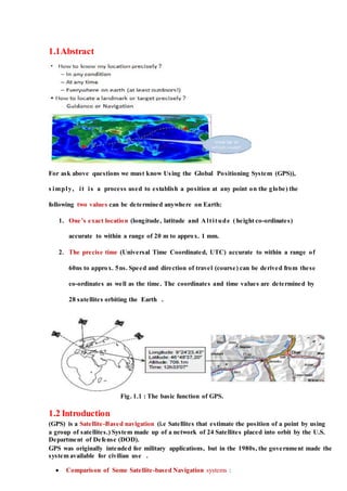
Fig. 1.1 : The basic function of GPS.
1.2 Introduction
(GPS) is a Satellite-Based navigation (i.e Satellites that estimate the position of a point by using
a group of satellites.) System made up of a network of 24 Satellites placed into orbit by the U.S.
Department of Defense (DOD).
GPS was originally intended for military applications, but in the 1980s, the government made the
system available for civilian use .
Comparison of Some Satellite-based Navigation systems :
2.
3. 1.3 History of GPS
Prior to the development of the GPS system, the first satellite system was called Transit and
was operational beginning in 1964. Transit had no timing devices aboard the satellites and
the time it took a receiver to calculate its position was about 15 minutes. Yet, much was
learned from this system. GPS is a great improvement over the Transit system. The original
use of GPS was as a military positioning, navigation, and weapons aiming system to replace
not only Transit, but other navigation systems as well. It has higher accuracy and stable
atomic clocks on board to achieve precise time transfer.
The first GPS satellite was launched in 1978 and the first products for civilian consumers
appeared in the mid 1980's. It was in 1984 that President Reagan announced that a portion
of the capabilities of GPS would be made available to the civil community. The system is
still being improved and new, better satellites are still being launched to replace older ones.
1.4 What is GPS?
The Global Positioning System (GPS) is a location system based on a constellation of about
24 satellites orbiting the earth at altitudes of approximately 11,000 miles. GPS was
developed by the United States Department of Defense (DOD), for its tremendous
application as a military locating utility. The DOD's investment in GPS is immense. Billions
and billions of dollars have been invested in creating this technology for military uses.
However, over the past several years, GPS has proven to be a useful tool in non- military
mapping applications as well.
GPS satellites are orbited high enough to avoid the problems associated with land based
systems, yet can provide accurate positioning 24 hours a day, anywhere in the world.
4. Un-corrected positions determined from GPS satellite signals produce accuracies in the
range of 50 to 100 meters. When using a technique called differential correction, users can
get positions accurate to within 5 meters or less.
Fig. 1.2 : GPS constellation
Today, many industries are leveraging off the DOD's massive undertaking. As GPS units
are becoming smaller and less expensive, there are an expanding number of applications for
GPS. In transportation applications, GPS assists pilots and drivers in pinpointing their
locations and avoiding collisions. Farmers can use GPS to guide equipment and control
accurate distribution of fertilizers and other chemicals. Recreationally, GPS is used for
providing accurate locations and as a navigation tool for hikers, hunters and boaters Many
would argue that GPS has found its greatest utility in the field of Geographic Information
Systems(GIS).
5. With some consideration for error, GPS can provide any point on earth with a unique
address (its precise location). A GIS is basically a descriptive database of the earth (or a
specific part of the earth). GPS tells you that you are at point X,Y,Z while GIS tells you that
X,Y,Z is an oak tree, or a spot in a stream with a pH level of 5.4. GPS tells us the "where".
GIS tells us the "what". GPS/GIS is reshaping the way we locate, organize, analyze and
map our resources
1.5 How it Works
GPS satellites circle the earth twice a day in a very precise orbit and transmit signal
information to earth. GPS receivers take this information and use triangulation to calculate
the user's exact location. Essentially, the GPS receiver compares the time a signal was
transmitted by a satellite with the time it was received.
The time difference tells the GPS receiver how far away the satellite is. Now, with distance
measurements from a few more satellites, the receiver can determine the user's position and
display it on the unit's electronic map.
A GPS receiver must be locked on to the
signal of at least three satellites to
calculate a 2D position (latitude and
longitude) and track movement. With
four or more satellites in view, the
receiver can determine the user's 3D
position (latitude, longitude and
altitude). Once the user's position has
been determined, the GPS unit can
calculate other information, such as
speed, bearing, track, trip distance,
distance to destination, sunrise and
sunset time and more.
6. 1.6 The GPS Satellite System
The 24 satellites that make up the GPS space segment are orbiting the earth about 12,000
miles above us. They are constantly moving, making two complete orbits in less than 24
hours. These satellites are travelling at speeds of roughly 7,000 miles an hour. GPS satellites
are powered by solar energy. They have backup batteries onboard to keep them running in
the event of a solar eclipse, when there's no solar power.
Fig. 1.3 : GPS Satellite System
Here are some other interesting facts about the GPS satellites (also called
NAVSTAR, the official U.S. Department of Defense name for GPS):
The first GPS satellite was launched in 1978.
A full constellation of 24 satellites was achieved in 1994.
Each satellite is built to last about 10 years. Replacements are constantly being
built and launched into orbit.
7. A GPS satellite weighs approximately 2,000 pounds and is about 17 feet across
with the solar panels extended.
Transmitter power is only 50 watts or less.
1.7What's a GPS Signal?
We have seen that the entire system of GPS is dependent on a network of 24 satellites
orbiting the earth. While research and development work is still going on to develop more
and more accurate systems, it would be a good idea to understand what the external sources
of error are.
There are two frequencies of low power radio signals that GPS satellites transmit. These
are called L1 and L2. The L1 frequency at 1575.42 MHz in the UHF band is what comes
into play for civilian applications. These signals can pass through clouds, glass, plastic and
such light objects, but cannot go through more solid objects like buildings and mountains.
The L2 frequency at 1227.60 MHz for military uses .
Every GPS signal packs three bits of
information- these are the pseudorandom
code, ephemeris data and almanac data. The
pseudorandom code is the identification code
of the individual satellite. The ephemeris data
identifies the location of each GPS satellite at
any particular time of the day. Each satellite
transmits this data for the GPS receivers as
well as for the other satellites in the network.
The almanac data has information about the
status of the satellite as well as current date
and time. The almanac part of the signal is
essential for determining the position.
8. 1.8 Sources of GPS Signal Error:
Apart from the inaccuracy of the clock in the GPS receiver, there can be other factors that
affect the quality of the GPS signal and cause calculation errors. These are:
Atmospheric Conditions:
The ionosphere and troposphere both refract the GPS signals. This causes the speed of the
GPS signal in the ionosphere and troposphere to be different from the speed of the GPS
signal in space. Therefore, the distance calculated from "Signal Speed x Time" will be
different for the portion of the GPS signal path that passes through the ionosphere and
troposphere and for the portion that passes through space
Fig. 1.4 : Sources of GPS Signal Error
Signal reflection: here the signal hits and is reflected off objects like tall buildings, rocks
etc. This causes the signal to be delayed before it reaches the receiver. Ephemeris errors:
9. Ephemeris errors are also known as orbital errors. These are errors in the satellite’s
reported position against its actual position.
Clock errors: The built in clock of the GPS receiver is not as accurate as the atomic
clocks of the satellites and the slight timing errors leads to corresponding errors in
calculations.
Visibility of Satellites: The more the number of satellites a GPS receiver can lock
with, the better its accuracy. Buildings, rocks and mountains, dense foliage,
electronic interference, in short everything that comes in the line of sight cause
position errors and sometimes make it unable to take any reading at all. GPS
receivers do not work indoors, underwater and underground.
Satellite Shading: For the signals to work properly the satellites have to be placed at
wide angles from each other. Poor geometry resulting from tight grouping can result
in signal interference.
Fig. 1.5 : Satellite Shading
10. Table 1.1 : Satellite Error
1.9 Determining GPS Position
GPS receivers calculate the position of objects in two dimensional or three dimensional
space using a mathematical process called trilateration. Trilateration can be either two
dimensional or three dimensional. Let us examine how 2-D and 3-D trilateration work.
2-D Trilateration
The concept of trilateration is easy to understand through an example. Imagine that you
are driving through an unfamiliar country and that you are lost. A road sign indicates that
you are 500 km from city A. But this is not of much help, as you could be anywhere in a
circle of 500 km radius from the city A. A person you stop by to ask for directions then
volunteers that you are 450 km from city B. Now you are in a better position to locate
yourself- you are at one of the two intersecting points of the two circles surrounding city A
and city B. Now if you could also get your distance from another place say city C, you can
11. locate yourself very precisely, as these three circles can intersect each other at just one
point. This is the principle behind 2D trilateration.
Fig . 1.6 : D Trilateration
3-D Trilateration
Fig. 1.7 : Estimate Black Point
The fundamental principles are the same for 2D and 3D trilateration, but in 3D
trilateration we are dealing with spheres instead of circles. It is a little tricky to visualize.
12. Here, we have to imagine the radii from the previous example going in all directions, which
is in three dimensional space, thus forming spheres around the predefined points. Therefore
the location of an object has to be defined with reference to the intersecting point of three
spheres.
Thus if you learn that the object is at a distance of 100 km from satellite A, it simply says
that the object could be on surface of a huge imaginary sphere of 100 km radius around
satellite A. Now you are also informed that the object is 150 km from satellite B. The
imaginary spheres of 100km and 150 km around satellites A and B respectively intersect in
a perfect circle.
The position of the object defined from a third satellite C intersects this circle at just two
points. The Earth acts as the fourth sphere, making us able to eliminate one of the two
intersection points of the first three spheres. This makes it possible to identify the exact
location of the object.
However GPS receivers take into account four or more satellites to improve accuracy and
provide extra information like altitude of the object. Thus the GPS receiver needs the
following information for its calculations.
The location of a minimum of three satellites that lock in with the object to be
located or tracked.
The distance between the object and each of these satellites.
The GPS receiver works this out by analyzing high-frequency radio signals from GPS
satellites. The more sophisticated the GPS, the more its number of receivers, so that signals
from a larger number of satellites are taken into account for the calculations.
13. Details of the GPS position calculation
The GPS calculation in the receiver uses four equations in the four unknowns x, y, z, tc, where x,
y, z are the receiver’s coordinates, and tc is the time correction for the GPS receiver’s clock. The
four equations are:
where
c = speed oflight (3 ´ 108
m/s)
tt,1, tt,2, tt,3, tt,4 = times that GPS satellites 1, 2, 3, and 4, respectively, transmitted their
signals (these times are provided to the receiver as part of the information that is
transmitted).
tr,1, tr,2, tr,3, tr,4 = times that the signals from GPS satellites 1, 2, 3, and 4, respectively, are
received (according to the inaccurate GPS receiver’s clock)
x1, y1, z1 = coordinates of GPS satellite 1 (these coordinates are provided to the receiver
as part of the information that is transmitted); similar meaning for x2, y2, z2, etc.
The receiver solves these equations simultaneously to determine x, y, z, and tc.
14. 1.10 The Parts of GPS
GPS consists of three main segments:
1. The Space Segment:
This part consists of 24 satellites, manufactured by Rockwell International, which are
launched into space by rockets, from Cape Canaveral, Florida. They are about the size of a
car, and weigh about 19,000lbs.
Each satellite is in orbit above the earth at an altitude of 11,000 nautical miles (12,660
miles), and takes 12 hours to orbit one time. There are 6 orbital planes each having 4
satellites. The orbits are tilted to the equator of the earth by 55° so that there is coverage of
the Polar Regions.
15. The satellites continuously orient themselves to ensure that their solar panels stay pointed
towards the sun, and their antennas point toward the earth. Each satellite carries 4 atomic
clocks.
Fig.1.8 : Space Segment GPS
2. The Control Segment:
A- In ancient times
This part consists of 5 worldwide unmanned base -stations that monitor the satellites to
track their exact position in space, and to make sure that they are operating correctly. The
stations constantly monitor the orbits of the satellites and use very precise radar to check
altitude, position and speed. Transmitted to the satellites are ephemeris constants and clock
adjustments. The satellites in turn, use these updates in the signals that the y send to GPS
receivers.
GPS Base-Station Location Map The main base-station is in Colorado Springs, Colorado
and the other four are located on Ascension Island (Atlantic Ocean), Diego Garcia (Indian
Ocean) and Kwajalein and Hawaii (both Pacific Ocean).
16. Fig. (1.9-A) : Control Segment Of GPS ( In ancient times)
Fig. (1.9-B) : Control Segment Of GPS ( Recently)
B –Recently
The GPS control segment consists of a global network of ground facilities that track the GPS
satellites, monitor their transmissions, perform analyses, and send commands and data to the
constellation.
The current operational control segment includes a master control station, an alternate master
control station, 12 command and control antennas, and 16 monitoring sites. The locations of
these facilities are shown in the map above
17. Control Segment Elements
A-Master Control Station (MCS)
The master control station in Colorado is where 2SOPS performs the primary control segment
functions, providing command and control of the GPS constellation. The MCS generates and
uploads navigation messages and ensures the health and accuracy of the satellite constellation. It
receives navigation information from the monitor stations, utilizes this information to compute
the precise locations of the GPS satellites in space, and then uploads this data to the satellites.
The MCS monitors navigation messages and system integrity, enabling 2SOPS to determine and
evaluate the health status of the GPS constellation. 2SOPS uses the MCS to perform satellite
maintenance and anomaly resolution. In the event of a satellite failure, the MCS can reposition
satellites to maintain an optimal GPS constellation.
B-Monitor Stations
Monitor stations track the GPS satellites as they pass overhead and channel their observations
back to the master control station. Monitor stations collect atmospheric data, range/carrier
measurements, and navigation signals. The sites utilize sophisticated GPS receivers and are
operated by the MCS.
There are 16 monitoring stations located throughout the world, including six from the Air Force
and 10 from the National Geospatial-Intelligence Agency (NGA).
18. C-Ground Antennas
Ground antennas are used to communicate with the GPS satellites for command and control
purposes. These antennas support S-band communications links that send/transmit navigation
data uploads and processor program loads, and collect telemetry. The ground antennas are also
responsible for normal command transmissions to the satellites. S-band ranging allows 2SOPS to
provide anomaly resolution and early orbit support.
There are four dedicated GPS ground antenna sites co-located with the monitor stations at
Kwajalein Atoll, Ascension Island, Diego Garcia, and Cape Canaveral. In addition, the control
segment is connected to the eight Air Force Satellite Control Network (AFSCN) remote tracking
stations worldwide, increasing visibility, flexibility, and robustness for telemetry, tracking, and
command.
3. The User Segment:
This part consists of user receivers which are hand-held or, can be placed in a vehicle. All
GPS receivers have an almanac programmed into their computer, which tells them where
each satellite is at any given moment. The GPS receivers detect, decode and process the
signals received from the satellites. The receiver is usually used in conjunction with
computer software to output the information to the user in the form of a map. As the user
does not have to communicate with the satellite there can be unlimited users at one time.
Fig. 1.10 : User Segment Of GPS
19. summary of three Segments:-
Fig.1.11(summary of Three segments Of GPS)
The Future of GPS :-
GPS Modernization
A-It is the policy of the United States to maintain U.S. leadership in the service, provision, and
use of satellite navigation systems. The U.S. government has additional policy goals to meet
growing demands by improving the performance of GPS services, and to remain competitive
with international satellite navigation systems
B-The GPS modernization program is an ongoing, multibillion-dollar effort to upgrade the GPS space and control
segments with new features to improve GPS performance. These features include new civilian and military signals.
C-In addition to the specific new features noted above, GPS modernization is introducing modern technologies
throughout the space and control segments that will enhance overall performance. For example, legacy computers
and communications systems are being replaced with a network-centric architecture, allowing more frequent and
precise satellite commands that will improve accuracy for everyone.
20. ProgramSchedule
The GPS modernization program involves a series of consecutive satellite acquisitions, including
GPS IIR(M), GPS IIF, and GPS III. It also involves improvements to the GPS control segment,
including the Architecture Evolution Plan (AEP) and the Next Generation Operational Control
System (OCX). The schedule for the parallel space and control segment upgrades is shown
below. The information on the schedule is correct as of May 2012.
1.12 Application
GPS is an essential element ofthe global information infrastructure. The free, open, and
dependable nature of GPS has led to the development of hundreds of applications affecting
every aspect of modern life. GPS technology is now in everything from cell phones and
wristwatches to bulldozers, shipping containers, and ATM's. Finally, GPS remains critical
21. to U.S. national security, and its applications are integrated into virtually every facet of U.S.
military operations. Nearly all new military assets -- from vehicles to munitions -- come
equipped with GPS.
22. Aviators throughout the world use the Global Positioning System (GPS) to increase the
safety and efficiency of flight. With its accurate, continuous, and global capabilities, GPS
offers seamless satellite navigation services that satisfy many of the requirements for
aviation users. Space-based position and navigation enables three-dimensional position
determination for all phases of flight from departure, en route, and arrival, to airport
surface navigation.
Marine
The Global Positioning System (GPS) has changed the way the world Operates. This is
especially true for marine operations, including search and rescue. GPS provides the fastest
and most accurate method for mariners to navigate, measure speed, and determine
location. This enables increased levels of safety and efficiency for mariners worldwide.
23. Surveying & Mapping
The surveying and mapping community was one of the first to take advantage of GPS
because it dramatically increased productivity and resulted in more accurate and reliable
data. Today, GPS is a vital part of surveying and mapping activities around the world.
24. Ail systems throughout the world use GPS to track the movement of locomotives, rail cars,
maintenance vehicles, and wayside equipment in real time. When combined with other
sensors, computers, and communications systems, GPS improves rail safety, security, and
operational effectiveness. The technology helps reduce accidents, delays, and operating
costs, while increasing track capacity, customer satisfaction, and cost effectiveness.
27. 1.11 SkyNav SKM53 Series
The SkyNav SKM53 Series with embedded GPS antenna enables high performance
navigation in the most stringent applications and solid fix even in harsh GPS
visibility environments.
It is based on the high performance features of the MediaTek 3327 single-chip
architecture, Its –165dBm tracking sensitivity extends positioning coverage into place
like urban canyons and dense foliage environment where the GPS was not possible
before. The 6-pin and USB connector design is the easiest and convenient solution to
be embedded in a portable device and receiver like PND, GPS mouse, car holder,
personal locator, speed camera detector and vehicle locator.
Fig.1.12:SkyNav SKM53 Series TopView
Features
1 Ultra high sensitivity: -165dBm
2 22 tracking/66 acquisition-channel receiver
3 WAAS/EGNOS/MSAS/GAGAN support
4 NMEA protocols (default speed: 9600bps)
5 Internal back-up battery and 1PPS output
6 One serial port and USB port (option)
7 Embedded patch antenna 18.2 x 18.2 x 4.0 mm
8 Operating temperature range: -40 to 85℃
9 RoHS compliant (Lead-free)
10 Tiny form factor :30mm x20mm x 11.4mm
28. Fig. 1.13: Pin Assignment
Pin Description
Pin No. Pin name I/O Description Remark
UART Port
1 VCC P Module Power Supply VCC: 5V ±5%
2 GND G Module Power Ground Reference Ground
3 NC O Not Open Leave Open
4 RST I Module Reset (Active Low Status)
5 TXD I TTL:VOH≥0.75 *VCC VOL≤0.25VCC Leave Open in not used
6 RXD O TTL:VIH ≥0.7 *VCC VIL ≤0.3 *VCC Leave Open in not used
Software Protocol
NMEA 0183 Protocol
The NMEA protocol is an ASCII-based protocol, Records start with a $ and with
carriage return/line feed. GPS specific messages all start with $GPxxx where xxx
is a three-letter identifier of the message data that follows. NMEA
messages have a checksum, which allows detectionof corrupted data transfers.
The SkyNavSKM53 series supports the following
NMEA-0183 messages:GGA, GLL, GSA, GSV, RMC
VTG, ZDA
Table 1: NMEA-0183 Output Messages
NMEA Record DESCRIPTION
GGA Global positioning systemfixed data
GLL Geographic position—latitude/longitude
GSA GNSS DOP and active satellites
GSV GNSS satellites in view
RMC Recommended minimum specific GNSS data
VTG Course over ground and ground speed
DA Time and Date
29. GGA-Global Positioning System Fixed Data
Table 2 contains the values of the following example:
$GPGGA, 083559.00,3723.2475,N, 12158.3416,W, 1,07,1.0,9.0,M, ,M, ,0000*18
Table 1.4: GGA Data Format
Name Example Units Description
Message ID $GPGGA GGA protocol header
UTC Time 083559.00 hhmmss.sss
Latitude 3723.2457 ddmm.mmmm
N/S indicator N N=north or S=south
Longitude 12158.3416 ddmm.mmmm
E/W Indicator W E=east or W=west
Position Fix Indicator 1 See Table 2-1
Satellites Used 07 Range 00 to 12
HDOP 1.0 Horizontal Dilution of Precision
MSL Altitude 9.0 meters Altitude above mean seal level
Units M meters
Geoids Separation meters Separation from Geoids can be bank
Units M meters
Age of Diff.Corr. second Null fields when DGPS is not Used
Diff.Ref.Station ID 0000 Null fields when DGPS is not Used
Checksum *18
<CR> <LF> End of message termination(ASCII 13, ASCII 10)
1.13 Gps Glossary and Acronyms
Glossary and Acronyms-Meaning
C/A code -The standard (Course/Acquisition) GPS code. A sequence of 1023 pseudo-
random, binary, biphase modulations on the GPS carrier at a chip rate of 1.023 MHz.
Also known as the "civilian code."
Control segment - A world-wide network of GPS monitor and control stations that ensure
the accuracy of satellite positions and their clocks.
Differential positioning - Accurate measurement of the relative positions of two receivers
tracking the same GPS signals.
DGPS - Differential GPS
Ephemeris - The predictions of current satellite position that are transmitted to the user in
the data message. A table given for successive days the positions of heavenly bodies.
GLONASS - GLObal NAvigation Satellite System – Russian
GPS - Global Positioning System
30. Latitude - the location on the Earth measuring how far north or south of the equator One
is.
Longitude - the location on the Earth measured east or west
LORAN - LOng RAnge Navigation
Nautical mile - length measurement used in navigation and is 1/60 of 1 degree of the
equator. One nautical mile is 6,080.2 feet whereas one mile is 5,280 feet.
NAVSTAR GPS - the Navigation Satellite Timing and Ranging GPS
P-code - The Precise code. A very long sequence of pseudo random binary biphase
modulations on the GPS carrier at a chip rate of 10.23 MHz which repeats about every
267 days. Each one week segment of this code is unique to one GPS satellite and is reset
each week.
Precise Positioning Service (PPS) - The most accurate dynamic positioning possible with
standard GPS, based on the dual frequency P-code and no SA.
Pseudolite - A ground-based differential GPS receiver which transmits a signal like that of
an actual GPS satellite, and can be used for ranging.
RTK - Real Time Kinematic
Satellite constellation - The arrangement in space of a set of satellites.
Selective Availability (SA) - A policy adopted by the Department of Defense to introduce
some intentional clock noise into the GPS satellite signals thereby degrading their
accuracy for civilian users.
Space segment - The part of the whole GPS systemthat is in space, i.e. the satellites.
Standard Positioning Service (SPS) - The normal civilian positioning accuracy obtained by
using the single frequency C/A code.
User segment - The part of the whole GPS systemthat includes the receivers of GPS
signals.
31. 1.14 GPS & Microconroller Arduino
let's take a peek