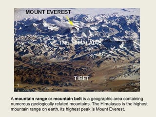
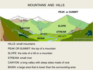
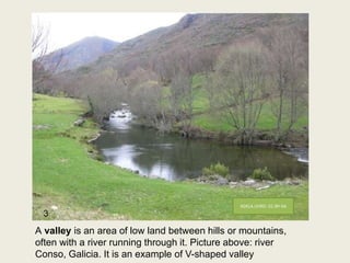
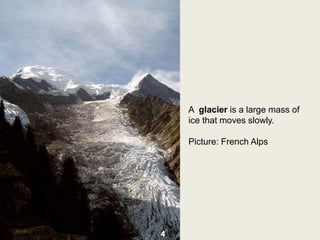
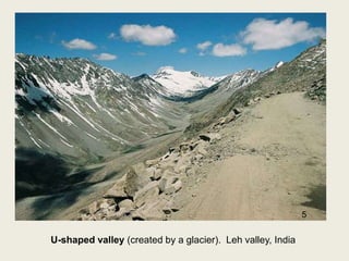
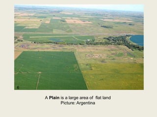
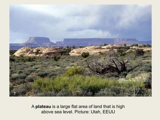
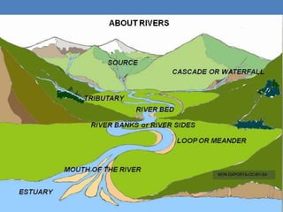
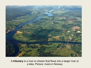
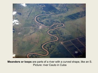
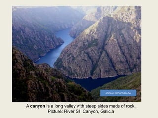
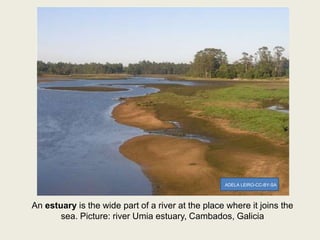
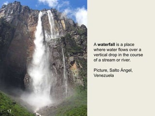
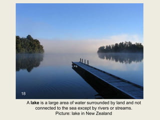
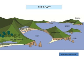
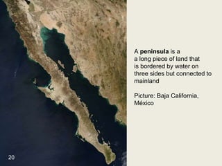
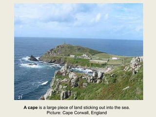
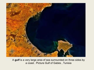
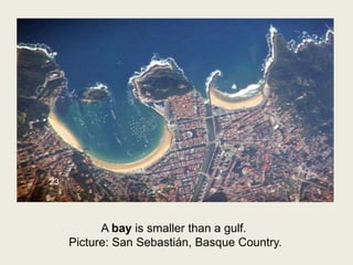
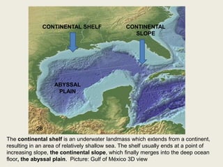
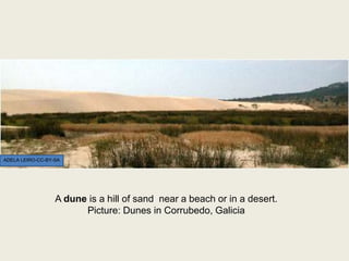
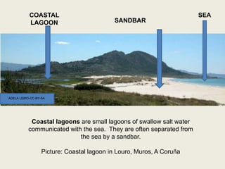
LANDFORMS
A mountain range or mountain belt is a geographic area containing
numerous geologically related mountains. The Himalayas is the highest
mountain range on earth, its highest peak is Mount Everest.
1
VALLEY
RIVER
PEAK or SUMMIT
SLOPE
BASIN
CANYON
MOUNTAINS AND HILLS
STREAM
HILLS: small mountains
PEAK OR SUMMIT: the top of a mountain
SLOPE: the side of a hill or a mountain
STREAM: small river
CANYON: a long valley with steep sides made of rock
BASIN: a large area that is lower than the surrounding area
MON DAPORTA- CC-BY-SA2
A valley is an area of low land between hills or mountains,
often with a river running through it. Picture above: river
Conso, Galicia. It is an example of V-shaped valley
ADELA LEIRO- CC-BY-SA
3
A glacier is a large mass of
ice that moves slowly.
Picture: French Alps
4
U-shaped valley (created by a glacier). Leh valley, India
5
A Plain is a large area of flat land
Picture: Argentina
6
A plateau is a large flat area of land that is high
above sea level. Picture: Utah, EEUU
7
MON DAPORTA-CC-BY-SA
A tributary is a river or stream that flows into a larger river or
a lake. Picture: rivers in Norway
9
Meanders or loops are parts of a river with a curved shape, like an S.
Picture: river Cauto in Cuba
10
A canyon is a long valley with steep sides made of rock.
Picture: River Sil Canyon, Galicia
ADELA LEIRO-CC-BY-SA
A Dam is a
wall built across a river that stops the
river's flow and collects the water ,
especially to make a reservoir
(=an artificial lake) that provides
water for an area.
Picture: Hoover’s dam, Nevada, US
12
A delta is
an area of low, flat land,
sometimes shaped like
a triangle, where a river
divides into
several smaller rivers
before flowing into
the sea.
Picture: Nile River,
Egipt
13
Ría is a galician word for a river valley flooded by the sea .
Picture: Cée-Corcubión, Galicia
ADELA LEIRO- CC-BY-SA
A fiord is the norwegian word
for a glacier valley flooded by
the sea. Picture: fiord in
Norway
15
An estuary is the wide part of a river at the place where it joins the
sea. Picture: river Umia estuary, Cambados, Galicia
ADELA LEIRO-CC-BY-SA
A waterfall is a place
where water flows over a
vertical drop in the course
of a stream or river.
Picture, Salto Ángel,
Venezuela
17
A lake is a large area of water surrounded by land and not
connected to the sea except by rivers or streams.
Picture: lake in New Zealand
18
MON DAPORTA-CC-BY-SA
A peninsula is a
a long piece of land that
is bordered by water on
three sides but connected to
mainland
Picture: Baja California,
México
20
A cape is a large piece of land sticking out into the sea.
Picture: Cape Corwall, England
21
A gulf is a very large area of sea surrounded on three sides by
a coast . Picture Gulf of Gabès , Tunisia
22
A bay is smaller than a gulf.
Picture: San Sebastián, Basque Country.
23
A cliff is a high area of
rock with a very steep
side, often on a coast.
Picture: Cliffs near the
Cape of Ortegal, A
Coruña
ADELA LEIRO- CC-BY-SA
An island or isle is a piece of land that is
surrounded by water
Picture: a small fijian island, Pacific Ocean
25
An arquipelago is a group of small islands.
Picture: Canary Islands
26
An atoll is is a ring-shaped coral reef including a coral rim
that encircles a lagoon partially or completely.
Picture: Atafu Atoll in Tokelau (Pacific Ocean)
27
CONTINENTAL SHELF CONTINENTAL
SLOPE
ABYSSAL
PLAIN
The continental shelf is an underwater landmass which extends from a continent,
resulting in an area of relatively shallow sea. The shelf usually ends at a point of
increasing slope, the continental slope, which finally merges into the deep ocean
floor, the abyssal plain. Picture: Gulf of México 3D view
28
A dune is a hill of sand near a beach or in a desert.
Picture: Dunes in Corrubedo, Galicia
ADELA LEIRO-CC-BY-SA
Coastal lagoons are small lagoons of swallow salt water
communicated with the sea. They are often separated from
the sea by a sandbar.
Picture: Coastal lagoon in Louro, Muros, A Coruña
COASTAL
LAGOON SANDBAR
SEA
ADELA LEIRO-CC-BY-SA
REFERENCIA DAS IMAXES QUE NON SE INDICAN
NA PROPIA DIAPOSITIVA
1- DOMINIO PÚBLICO- WIKIMEDIA COMMONS
4- GFDL- WIKIMEDIA COMMONS- CC-BY-SA
5- DAN HOBLEY- WIKIMEDIA COMMONS- CC-BY-SA
6- JAVIER GABRIELLI- WIKIMEDIA COMMONS-CC-BY-SA
7- QFL247- WIKIMEDIA COMMONS-CC-BY-SA
9- PEPPIGUE- WIKIMEDIA COMMONS -CC-BY-SA
10- DOMINIO PÚBLICO -WIKIMEDIA COMMONS
11-MIKANO- WIKIMEDIA COMMONS- CC-BY-SA
13- DOMINIO PÚBLICO- WIKIMEDIA COMMONS
15- Frédéric de Goldschmidt- WIKIMEDIA COMMONS- CC-BY-SA
17- POCOAPOCO- WIKIMEDIA COMMONS -CC-BY-SA
18- RICHARD PALMER- WIKIMEDIA COMMONS- CC-BY-SA
19- DOMINIO PÚBLICO- WIKIMEDIA COMMONS
21- TOM CORSER- WIKIMEDIA COMMONS -CC-BY-SA
22- DOMINIO PÚBLICO- WIKIMEDIA COMMONS
23- Hynek Moravec; modified by Generalpoteito- WIKIMEDIA COMMONS- CC-BY-SA
25- DOMINIO PÚBLICO- WIKIMEDIA COMMONS
26- DOMINIO PÚBLICO- WIKIMEDIA COMMONS
27- DOMINIO PÚBLICO- WIKIMEDIA COMMONS
28-DOMINIO PÚBLICO- WIKIMEDIA COMMONS
Dereitos de autor
Landforms. Maribel Iglesias Baldonedo, con licenza:
Dentro do curso: O tempo e o espazo con liñas e cores por Maribel
Iglesias e Manuel Busto. Baixo licenza
Creative Commons Reconocimiento-NoComercial-CompartirIgual 3.0
España.
Créditos e autoría:
Úsanse imaxes e recursos de produción propia, que se fan públicos con
licenza CC-BY-NC-SA, outras de dominio público, con licenza creative
commons, GNU... tomados preferentemente de bancos de recursos
educativos abertos. Tamén se empregan, acolléndose ao dereito de cita
segundo a lexislación vixente, imaxes e recursos diversos de diferentes
páxinas Web, e lígase -cando é posible- a súa licenza ao pé dos propios
recursos, que manteñen integramente.
Outras licenzas:
Quedan fora desta licenza as imaxes, recursos... que manteñen a súa
propia licenza, sinalada en cada caso.

Landforms

  • 1.
  • 2.
    A mountain rangeor mountain belt is a geographic area containing numerous geologically related mountains. The Himalayas is the highest mountain range on earth, its highest peak is Mount Everest. 1
  • 3.
    VALLEY RIVER PEAK or SUMMIT SLOPE BASIN CANYON MOUNTAINSAND HILLS STREAM HILLS: small mountains PEAK OR SUMMIT: the top of a mountain SLOPE: the side of a hill or a mountain STREAM: small river CANYON: a long valley with steep sides made of rock BASIN: a large area that is lower than the surrounding area MON DAPORTA- CC-BY-SA2
  • 4.
    A valley isan area of low land between hills or mountains, often with a river running through it. Picture above: river Conso, Galicia. It is an example of V-shaped valley ADELA LEIRO- CC-BY-SA 3
  • 5.
    A glacier isa large mass of ice that moves slowly. Picture: French Alps 4
  • 6.
    U-shaped valley (createdby a glacier). Leh valley, India 5
  • 7.
    A Plain isa large area of flat land Picture: Argentina 6
  • 8.
    A plateau isa large flat area of land that is high above sea level. Picture: Utah, EEUU 7
  • 9.
  • 10.
    A tributary isa river or stream that flows into a larger river or a lake. Picture: rivers in Norway 9
  • 11.
    Meanders or loopsare parts of a river with a curved shape, like an S. Picture: river Cauto in Cuba 10
  • 12.
    A canyon isa long valley with steep sides made of rock. Picture: River Sil Canyon, Galicia ADELA LEIRO-CC-BY-SA
  • 13.
    A Dam isa wall built across a river that stops the river's flow and collects the water , especially to make a reservoir (=an artificial lake) that provides water for an area. Picture: Hoover’s dam, Nevada, US 12
  • 14.
    A delta is anarea of low, flat land, sometimes shaped like a triangle, where a river divides into several smaller rivers before flowing into the sea. Picture: Nile River, Egipt 13
  • 15.
    Ría is agalician word for a river valley flooded by the sea . Picture: Cée-Corcubión, Galicia ADELA LEIRO- CC-BY-SA
  • 16.
    A fiord isthe norwegian word for a glacier valley flooded by the sea. Picture: fiord in Norway 15
  • 17.
    An estuary isthe wide part of a river at the place where it joins the sea. Picture: river Umia estuary, Cambados, Galicia ADELA LEIRO-CC-BY-SA
  • 18.
    A waterfall isa place where water flows over a vertical drop in the course of a stream or river. Picture, Salto Ángel, Venezuela 17
  • 19.
    A lake isa large area of water surrounded by land and not connected to the sea except by rivers or streams. Picture: lake in New Zealand 18
  • 20.
  • 21.
    A peninsula isa a long piece of land that is bordered by water on three sides but connected to mainland Picture: Baja California, México 20
  • 22.
    A cape isa large piece of land sticking out into the sea. Picture: Cape Corwall, England 21
  • 23.
    A gulf isa very large area of sea surrounded on three sides by a coast . Picture Gulf of Gabès , Tunisia 22
  • 24.
    A bay issmaller than a gulf. Picture: San Sebastián, Basque Country. 23
  • 25.
    A cliff isa high area of rock with a very steep side, often on a coast. Picture: Cliffs near the Cape of Ortegal, A Coruña ADELA LEIRO- CC-BY-SA
  • 26.
    An island orisle is a piece of land that is surrounded by water Picture: a small fijian island, Pacific Ocean 25
  • 27.
    An arquipelago isa group of small islands. Picture: Canary Islands 26
  • 28.
    An atoll isis a ring-shaped coral reef including a coral rim that encircles a lagoon partially or completely. Picture: Atafu Atoll in Tokelau (Pacific Ocean) 27
  • 29.
    CONTINENTAL SHELF CONTINENTAL SLOPE ABYSSAL PLAIN Thecontinental shelf is an underwater landmass which extends from a continent, resulting in an area of relatively shallow sea. The shelf usually ends at a point of increasing slope, the continental slope, which finally merges into the deep ocean floor, the abyssal plain. Picture: Gulf of México 3D view 28
  • 30.
    A dune isa hill of sand near a beach or in a desert. Picture: Dunes in Corrubedo, Galicia ADELA LEIRO-CC-BY-SA
  • 31.
    Coastal lagoons aresmall lagoons of swallow salt water communicated with the sea. They are often separated from the sea by a sandbar. Picture: Coastal lagoon in Louro, Muros, A Coruña COASTAL LAGOON SANDBAR SEA ADELA LEIRO-CC-BY-SA
  • 32.
    REFERENCIA DAS IMAXESQUE NON SE INDICAN NA PROPIA DIAPOSITIVA 1- DOMINIO PÚBLICO- WIKIMEDIA COMMONS 4- GFDL- WIKIMEDIA COMMONS- CC-BY-SA 5- DAN HOBLEY- WIKIMEDIA COMMONS- CC-BY-SA 6- JAVIER GABRIELLI- WIKIMEDIA COMMONS-CC-BY-SA 7- QFL247- WIKIMEDIA COMMONS-CC-BY-SA 9- PEPPIGUE- WIKIMEDIA COMMONS -CC-BY-SA 10- DOMINIO PÚBLICO -WIKIMEDIA COMMONS 11-MIKANO- WIKIMEDIA COMMONS- CC-BY-SA 13- DOMINIO PÚBLICO- WIKIMEDIA COMMONS 15- Frédéric de Goldschmidt- WIKIMEDIA COMMONS- CC-BY-SA 17- POCOAPOCO- WIKIMEDIA COMMONS -CC-BY-SA 18- RICHARD PALMER- WIKIMEDIA COMMONS- CC-BY-SA 19- DOMINIO PÚBLICO- WIKIMEDIA COMMONS 21- TOM CORSER- WIKIMEDIA COMMONS -CC-BY-SA 22- DOMINIO PÚBLICO- WIKIMEDIA COMMONS 23- Hynek Moravec; modified by Generalpoteito- WIKIMEDIA COMMONS- CC-BY-SA 25- DOMINIO PÚBLICO- WIKIMEDIA COMMONS 26- DOMINIO PÚBLICO- WIKIMEDIA COMMONS 27- DOMINIO PÚBLICO- WIKIMEDIA COMMONS 28-DOMINIO PÚBLICO- WIKIMEDIA COMMONS
  • 33.
    Dereitos de autor Landforms.Maribel Iglesias Baldonedo, con licenza: Dentro do curso: O tempo e o espazo con liñas e cores por Maribel Iglesias e Manuel Busto. Baixo licenza Creative Commons Reconocimiento-NoComercial-CompartirIgual 3.0 España. Créditos e autoría: Úsanse imaxes e recursos de produción propia, que se fan públicos con licenza CC-BY-NC-SA, outras de dominio público, con licenza creative commons, GNU... tomados preferentemente de bancos de recursos educativos abertos. Tamén se empregan, acolléndose ao dereito de cita segundo a lexislación vixente, imaxes e recursos diversos de diferentes páxinas Web, e lígase -cando é posible- a súa licenza ao pé dos propios recursos, que manteñen integramente. Outras licenzas: Quedan fora desta licenza as imaxes, recursos... que manteñen a súa propia licenza, sinalada en cada caso.