The document proposes enhancing the Blackwater crossing of the River Medina in the UK. Recent restoration efforts on the river have had some successes but also failures. The proposal suggests improvements like adding reed beds, wall coverings, and artificial riffles to improve habitat diversity and aesthetics. Considerations for the design include withstanding high flows and securing vegetation properly.
This document summarizes current understanding of geomorphic processes shaping the Willamette River floodplain and identifies key knowledge gaps. It outlines a proposed study to better understand landforms, channel processes, gravel transport, vegetation succession, and their relationships. The study would create detailed habitat and landform maps, evaluate gravel supply and transport, and assess channel and floodplain evolution over time to address major questions about how flows shape habitats and the balance between gravel supply and transport.
The document outlines a student capstone project to restore wetlands at the Francis Marion National Forest. The objectives are to develop engineering systems for soil and water management, design hydraulic structures, and evaluate designs based on effectiveness, cost, and environmental impacts. Approaches include surveying the site, analyzing soils, monitoring groundwater, modeling hydrology, and evaluating proposed solutions like bottom contouring, culvert removal, weirs, and low water crossings to restore the degraded hydrology and natural habitat.
Oyster castle addition at bennett's pointMadisonSocha
This document describes a study examining river bank erosion at Bennett's Point, South Carolina. Boats ignoring no-wake zones were throwing large wakes that were slowly eroding the river banks and destroying marsh grass. To address this, the author constructed a 100-foot long pyramid-shaped wall of oyster castles to block boat wakes. Over three years, the bank behind the wall built up sediment and grass regrew, demonstrating the effectiveness of oyster castles in preventing erosion from boat wakes. The author also used two models, WEPP and the soil loss equation, to show that observed erosion exceeded natural levels, proving it was caused by human activity from boats.
There are several strategies for river channel management including river channelization, river re-sectioning, vegetation planting and clearance, and bank protection. River channelization involves altering the river channel to increase water flow and prevent flooding by clearing obstacles and dredging. River re-sectioning straightens river meanders through cut-offs to shorten and increase water flow. Vegetation planting stabilizes banks but slows water flow while vegetation clearance improves flow but can damage banks. Bank protection uses structures like levees and dykes to prevent erosion during high water volumes.
The document discusses inundation mapping of the Willamette River Basin that will be used to assess how regulated flows influence the floodplain ecologically, socially, and economically. Inundation maps and GIS data will be created for the mainstem Willamette River from Eugene to Oregon City, as well as the Middle Fork and Coast Fork Willamette Rivers and McKenzie River, using available gage data and a topographic surface model. This information will provide a tool for restoration planning, historical wetlands analysis, and other efforts. Currently, mainstem Willamette River inundation maps and data are available online, with additional maps and data to come for other areas.
The document discusses a project to protect a silt bench and levee along the Puyallup River from erosion using a naturalized approach. It describes how past engineering solutions failed to consider important natural factors like vegetation, snags, and natural shoreline development. The solution was to design a complex, dynamic revetment that emulates a natural riparian shoreline using large interlocking stones and wood debris. This self-settling design simulates how snags anchor and protect river banks, with the goal of evolving naturally over time like a real riparian zone. The revetment was constructed simply and cost significantly less than traditional engineered approaches.
This report analyzes the historical landscape and ecology of Coyote Creek watershed before intensive human modification to understand how the area has changed and to identify opportunities for restoration. The report finds that historically the watershed contained a diverse mosaic of habitats including native grasslands, oak savanna, wet meadows, and freshwater wetlands. However, drainage intensification, agriculture, and development have significantly altered the watershed's hydrology and habitats. Understanding these historical conditions provides a basis for more appropriate restoration goals that consider recovering locally-adapted habitat types and restoring natural watershed functions.
The document discusses different measures for river channel management including realignment, re-sectioning, bank protection, and vegetation planting. It compares the effectiveness of each measure, noting their benefits in increasing water flow but also negative impacts like flooding downstream, destruction of ecosystems, and sedimentation reducing capacity over time. An ideal approach combines measures to maximize flood prevention while minimizing environmental effects.
The document summarizes tidal marsh restoration techniques used in the Northeast United States, including tidal reconnection projects, fill removal to restore degraded marshes, and thin-layer sediment placement to combat marsh edge erosion and plant dieback. Specific restoration case studies are described for Gooseneck Cove, RI and Pepper Creek Marsh, DE that involved culvert installation and sediment spraying to reconnect tidal flow. Larger scale fill placement projects in Jamaica Bay, NY are also summarized, where soil volumes from 1-5 feet were used to restore over 150 acres of marsh islands between 2006-2013.
Duke Bitsko - Alewife Stormwater Wetlandbio4climate
Duke Bitsko, landscape architect with Chester Engineers describes a large-scale project he worked on in the Alewife Reservation, transforming a degraded low-quality upland habitat into a constructed stormwater wetland and park. The interdisciplinary team incorporated green infrastructure strategies to create diverse upland and wetland native plant communities.
Presented at the Urban and Suburban Carbon Farming to Reverse Global Warming conference at Harvard University on May 3, 2015, organized by Biodiversity for a Livable Climate.
www.bio4climate.org
This document summarizes a study that examined the links between groundwater quality, residence times, and regional geology in the St. Lawrence Lowlands region of Quebec, Canada. The study focused on a 4,500 km2 watershed and analyzed samples from 150 wells for major ions and other parameters. Tritium, helium isotopes, and radiocarbon dating were used to estimate groundwater residence times ranging from under 5 years to over 60 years. Higher residence times were correlated with more evolved water chemistries. Elevated concentrations of barium, fluoride, iron, and manganese that exceeded drinking water limits were found to originate from Paleozoic bedrock units due to hydrothermal fluid circulation and subglacial recharge
Ecological engineering group 10 presentationColinRichter3
This document summarizes a study evaluating the success of restoring two barrier islands in Louisiana. The islands, Whiskey and Raccoon Islands, were restored by dredging sand to increase their elevation. Researchers then monitored the islands over three years to evaluate whether the restoration supported ecological processes. They found that plant coverage increased on both islands, showing the restoration was successful at establishing vegetation. Species richness was higher on the restored areas of Whiskey Island compared to the reference sites. The restoration approaches of increasing elevation appeared to successfully combat coastal land loss and erosion in Louisiana.
Sneen & Rochotte SFS Poster 2015 FINAL VERSIONMarty Sneen
PCB contamination from a nearby steel facility led to the remediation and restoration of two streams, Dicks Creek and Monroe Ditch, from 2010-2013. Remediation involved removing over 174,500 metric tons of contaminated sediment and floodplain soils. Restoration included designs to improve sinuosity and aquatic habitats. Post-remediation monitoring in 2014 found improvements in habitat and biological communities, including increased fish and macroinvertebrate species and metrics meeting or exceeding biological criteria.
The document summarizes assessments of stream restoration and stormwater projects funded by the CWMTF. It discusses the types of restoration and stormwater projects funded, methods used to assess the projects, findings from site visits by field representatives, and presentations made on various project types including stream restoration, wetland restoration, agricultural BMPs, and stormwater BMPs. Key highlights include that most funded projects showed water quality benefits and compliance with goals, though some required maintenance and repairs, and presentations provided examples and findings on different best management practices.
This document provides information about the Eugene Field Park Aquatic Ecosystem Restoration Program that took place from 2011-2016. The project involved restoring a 10-acre urban park and stream area by removing invasive plants and filling, constructing rock check dams in the river, excavating 20,000 cubic yards of fill to restore historic wetland depressions, and planting over 100 native plant species. Monitoring showed the restored areas became colonized by muskrats and plant growth was successful except along the river bank, demonstrating progress towards restoring the park's natural aquatic ecosystem.
This document summarizes restoration efforts at Middle Harbor on Lake Erie to restore coastal wetlands and hydrologic connectivity. A water control structure was constructed to reintroduce Lake Erie water levels and exchange. Monitoring shows improvements in water quality and species abundance compared to a control site. The long term goal is to sustain high quality coastal marsh through natural Lake Erie hydrology. Adaptive management will be used to refine water level management.
Limnological and Ecological sensitivity of Rwenzori mountain lakes (Uganda - DR Congo) to climate warming. Presented by Hilde Eggermont by "Perth II: Global Change and the World's Mountains" conference in Perth, Scotland in September 2010.
This document summarizes how natural coastal systems function to control pollution and prevent flooding and storm damage, and the effects of human alterations on these systems. It describes how features like salt marshes, beaches, wetlands and their vegetation naturally improve water quality, attenuate waves and floods, but that activities like coastal development, dams, pollution and draining/filling of habitats have degraded these ecosystem services. The Division of Ecological Restoration works to restore over 1,000 acres of coastal wetlands and 200 miles of streams to regain these lost benefits.
1) The document discusses environmental flows and management scenarios for sustaining river ecosystems. It describes global declines in river health due to loss of flows and impacts of flow regime changes.
2) Two management scenarios are presented: determining environmental flows for a new reservoir, and prioritizing flows for multiple assets with limited water. Assessment methods ranging from rapid to comprehensive are discussed.
3) The ecological significance of natural flow regimes is explored, with flow identified as a master variable influencing physical/chemical characteristics and species distributions in rivers and floodplains.
The Shetland Court Outfall Restoration project was substantially completed on September 7, 2018. The primary goals of this project were to address public safety concerns, stabilize an eroded channel by using natural stream design techniques, promote the growth of native vegetation, and improve water quality. The natural channel design techniques used, such as a reinforced bed mix riffle sections, step pools and rock steps, reduce the flow velocity, provide stability, and enhance water quality along the streams leading to the Chesapeake Bay. The disturbed areas of the site were restored with native shrubs, plants and trees.
The document discusses sea level rise impacts and considerations for resilience planning in Great Marsh communities. It provides an overview of coastal inundation mapping elements like tide ranges, sea level rise projections, and elevation data. Critical factors for modeling marsh migration under sea level rise are examined, such as sediment accretion rates. The document also analyzes how development and infrastructure can limit natural marsh migration inland. Strategies to support natural resilience by allowing natural processes like wetland migration are suggested.
This document summarizes a hydrogeological study of the Mole Creek Karst system in Tasmania, Australia. The study aimed to identify karst catchments potentially influenced by contamination from an abandoned landfill (the Mole Creek Refuse Disposal Site) and determine if it was affecting water quality in Sassafras Creek. The study used water tracing experiments, hydrogeochemical analysis, and geophysical resistivity surveys. These demonstrated groundwater flow from the landfill through sinkholes into the aquifer feeding Sassafras Creek. Hydrogeochemical analysis detected contamination in Marakoopa Creek within a UNESCO World Heritage site, though the source is unknown. Geophysics identified a drainage pathway beneath a landfill pit transport
The Lazy Creek Court Outfall Restoration Project in Fairfax County, Virginia restored 159 linear feet of an eroded outfall channel. The project addressed public safety concerns and stabilized the channel using natural stream design techniques like stone steps and plantings. This provides enhanced water quality through reduced nitrogen, phosphorus, and solid pollutants. The project was completed in August 2017 through collaboration between the Department of Public Works, a design firm, construction crews, and landscaping contractors.
This document discusses three projects underway in Salem, Massachusetts to address flooding and water quality issues:
1) The Collins Cove Living Shoreline project which aims to install plantings and biodegradable materials to create a fringing salt marsh and reduce erosion.
2) The South River Flood Mitigation Project which plans to install underground storage and pumps to detain stormwater runoff in order to reduce flooding in low-lying areas near the South River.
3) Improvements to stormwater management through green infrastructure projects like rain gardens to capture and clean rainwater running off of impervious surfaces and into waterways like the North River.
The Babson Court Outfall Restoration Project in Fairfax County, VA restored a 324-foot outfall channel and 66-foot tributary to address erosion and public safety concerns. The restoration incorporated natural stream design techniques like step pools, rock steps, and riffles. It also removed 250 cubic yards of sediment from a dry pond, which was re-vegetated. The project is expected to reduce nitrogen, phosphorus, and suspended solid pollution in stormwater runoff.
The Journal of The Earth Science and Climate Change is peer reviewed academic journal that cater to the needs of Earth Scientists, farmers, extensive agents, researchers and students. This Open access journal publishes high quality articles following rigorous and standard review procedure.
Ridges have lower rates of erosion than coves, resulting in thinner soils and depleted rock-derived minerals. This leads to shorter trees that branch closer to the ground. Coves have higher erosion rates, replenishing soils with minerals and allowing taller trees to grow without branching. Soil samples along hillslopes in El Yunque Forest, Puerto Rico showed decreasing secondary mineral content from coves to ridges, supporting the hypothesis that topography controls forest structure by regulating erosion and soil nutrients.
Climate Change is the most sought after a topic discussed very prominently in the media during this millennium as the Earth and the Environment is the worst affected due to it. Factors like global warming is leading to rise in Global Temperature, resulting melting polar ice, rising sea levels, high level of air pollution are affecting the quality of living for both men and animals.
The document is a 17-page geography SBA report by Okay-Lia Buchanan investigating how wave processes contribute to coastal landform formation in Hellshire, St. Catherine, Jamaica. The study was conducted along 500 meters of coastline near Cliff Boulevard on October 3rd, 2022. Various coastal features were observed including two headlands, a bay, a cliff, and two berms. Data on wave types and frequencies were collected through observation and using a stopwatch. Spilling and surging waves were found to be most effective at sediment deposition. In conclusion, the fieldwork provided insight into how erosion and deposition by wave activity influenced the coastal landforms in the study area.
This document summarizes a study of erosion control techniques used by homeowners along the Severn River. Through interviews and site observations, the study examined a variety of structural (e.g. bulkheads, revetments) and non-structural (e.g. vegetation) techniques used to stabilize slopes. The location of each technique was mapped using GIS to analyze how factors like slope, elevation, wind exposure, and soil type relate to erosion risks and choice of mitigation approach. The study found that steeper slopes facing areas with higher wind and wave exposure were more prone to erosion. Homeowners with more financial means could implement hybrid structural-nonstructural approaches most effectively.
This is a pamphlet I made for the Hui Aloha O Kiholo community group in Kona that describes the current findings of research I am conducting at Kiholo Bay.
The document summarizes a study on variations in groundwater flow potential in parts of Imo State, Nigeria. Ten boreholes across the study area underlain by the Benin Formation were investigated. Transmissivity values, which indicate groundwater flow potential, ranged from 311.04 to 388,800 m2/day. The highest potential was at Futo borehole, while the lowest was at Uratta. The study area was segmented into areas of moderate and high potential. Areas with lower hydraulic conductivity and transmissivity values generally had moderate potential, while others with higher values had high potential. The groundwater flow potential model shows potential increases from north to south. The transmissivity values obtained can support sustainable groundwater
This document discusses a study that evaluated the impact of changing land use/land cover (LULC) on the hydrological processes in the Dal lake catchment in Kashmir Himalayas from 1992 to 2005. Satellite data and a hydrological model were used to analyze LULC changes over time, identify factors contributing to changes, and simulate the effects on runoff, erosion, and sedimentation. The results showed that decreased vegetation cover and increased impervious surfaces due to human activities led to greater runoff, erosion, and sediment discharge, disrupting the lake ecosystem.
The International Journal of Engineering and Science (The IJES)theijes
The International Journal of Engineering & Science is aimed at providing a platform for researchers, engineers, scientists, or educators to publish their original research results, to exchange new ideas, to disseminate information in innovative designs, engineering experiences and technological skills. It is also the Journal's objective to promote engineering and technology education. All papers submitted to the Journal will be blind peer-reviewed. Only original articles will be published.
The papers for publication in The International Journal of Engineering& Science are selected through rigorous peer reviews to ensure originality, timeliness, relevance, and readability.
Relationship of qualitative and quantitative fisheries diversity with the environmental variables was studied for the period of two years along the three zones, viz. upper, middle and lower, of the Ulhas River estuary. Total ten hydro-sedimentological parameters were analyzed on monthly basis from each zone to depict ambient pollution level. Zones with comparatively higher pollution level deterred fisheries landings. The principal coordination analysis (PCO) ordination and zonewise K-dominance curves revealed the direct correlation of fish diversity with the existent spatial environmental conditions of the Ulhas River estuary.
Keywords: hydrological conditions, parameters, water pollution, Ulhas River, estuary, fisheries, diversity, landings, water color, phosphates, nitrates, DO, BOD, organic carbon, silt, principal coordination analysis.
Gully erosion occurs when incised channels form along overland flow paths or within watercourses. It begins with the formation of a nick point or head cut, which then migrates upstream through head cut erosion. This forms the gully and steep, unstable banks. Common causes of gully erosion include land clearing, urbanization, exposure of weak subsurface soils, lateral bank erosion, and poorly designed or constructed culverts. Gully erosion can lead to significant soil and sediment loss from the landscape and cause downstream water quality and habitat issues.
This study assessed the ecological health of High Bank Creek three years after dam removal by comparing it to nearby Cedar Creek. Macroinvertebrates and fish were surveyed to evaluate the stream health. Twenty-six fish species were found in High Bank Creek compared to nine in Cedar Creek. Several metrics showed improved conditions in High Bank Creek, such as higher fish biodiversity index and presence of species previously absent. However, some metrics like macroinvertebrate richness were lower, possibly due to ongoing disturbance. Overall the dam removal appeared successful in restoring the fish community, and further stabilization was expected to improve conditions over time.
The ICAR Indian Institute of Water Management was established in 1988 and aims to develop improved water management technologies through research. It conducts research through five programs: rainwater management, canal water management, groundwater management, waterlogged area management, and on-farm research and technology transfer.
The document then discusses the design of creek irrigation systems. It defines tidal creeks and explains how salinity varies in creeks over tidal cycles. It also discusses factors that influence salinity changes like urbanization. The document outlines the process for designing creek irrigation systems which includes determining design discharge, selecting a cross-sectional shape based on soil type and erosion control needs, using Manning's formula to calculate dimensions, and adding freeboard
The document proposes a plan for road construction near Nichol's Lake that would require altering several wetlands. It describes 7 wetlands that would be impacted, classified as swamps or fens. It assesses potential interactions with hydrology, soils, and ecology, such as increased runoff, sedimentation, changes to plant communities, and effects to fish habitat. The document recommends mitigation measures to avoid, minimize and compensate for wetland impacts from the road construction.
Three arrays of MacroRhizone pore water samplers were deployed at the abandoned Devon Great Consols mine site to investigate water-substrate interactions and potential environmental contamination. Samples were taken from three distinct tailings types - copper, tin, and arsenic tailings - deposited at different stages of the mine's history. Pore water compositions varied significantly between tailings types, with copper tailings highest in copper, aluminum, and manganese, tin tailings highest in tin but lowest in other metals, and arsenic tailings highest in arsenic, sodium, and strontium but lowest in copper. This suggests ongoing geochemical processes influence pore water compositions differently in each tailings type. SEM-EDX analysis showed
This document provides an overview of Puget Sound restoration efforts, focusing on estuaries, deltas, beaches and bluffs. It discusses the productivity of estuaries but also the degradation issues they face from pollution, overfishing and poor land management practices. The Nooksack River Delta restoration project aims to remove levees and dikes that disrupt natural water flows, restoring tidal channels and floodplains to improve conditions for fish and wildlife. The Lilliwaup Estuary project replaced a causeway and restored estuary processes to benefit local ecology. Puget Sound restoration addresses improving natural conditions across different habitat types to enhance the overall health of the sound.
2015 CDA-Frederickhouse Erosion Controlshiqiang Ye
This document summarizes the bank erosion control measures implemented at the Frederickhouse Dam in Ontario. Significant erosion was undercutting the 28m high left bank downstream of the dam due to turbulent discharge. Monitoring after a large landslide identified the need to stabilize the slope. Tests were conducted to determine soil properties, and a Flow-3D model was used to simulate flow patterns and evaluate design options. The final design included a stabilizing berm and armourstone riprap to arrest further erosion and meet safety standards, with construction completed in 2014.
IMPACT OF SILTATION AND RECLAMATION ON AQUATIC HABITAT.pptxSakshi Patil
Silt is a granular material between sand and clay that can exist as soil or sediment suspended in water. High levels of silt in rivers, known as siltation, is caused by erosion and human activities like agriculture, mining, and construction. Siltation decreases light penetration in water and inhibits photosynthesis, reducing primary productivity and harming aquatic plants and algae. It can also damage gills of fish and kill them. Siltation ultimately harms aquatic ecosystems by reducing food sources and degrading habitat for fish and invertebrates.
Potential hydrogeological, environment and vulnerability to pollution of the ...Alexander Decker
This document summarizes a study on the potential hydrogeology, environment, and vulnerability to pollution of aquifers in the coastal basin of Essaouira, Morocco. The region contains two main aquifers - the Plio-Quaternary and Turonian. Mapping showed that 61% of the region has high vulnerability to pollution, 20% has very high vulnerability, and 15% has medium vulnerability. Areas of very high vulnerability are located in the western coastal area. Groundwater flow is generally from southeast to northwest, influenced by the regional geology. The aquifers provide drinking water and irrigation but are threatened by overuse, seawater intrusion, and potential pollution from development.
Potential hydrogeological, environment and vulnerability to pollution of the ...Alexander Decker
This document summarizes a study on the potential hydrogeology, environment, and vulnerability to pollution of aquifers in the coastal basin of Essaouira, Morocco. The region contains two main aquifers - the Plio-Quaternary and Turonian. Analysis found the aquifers highly vulnerable to pollution, with 61% highly vulnerable and 20% very highly vulnerable. Vulnerability was highest in the western coastal area and decreased moving eastward. Water quality analysis found the Plio-Quaternary groundwater to be of varying salinity, dominated by sodium and chloride ions, indicating vulnerability to seawater intrusion if overexploited.
Similar to Kerwin Abinoja - ENVE341 Research Poster November 2015 (Assessing River Recovery in the Fish River after Sand and Gravel Extraction) (20)
Optimizing Post Remediation Groundwater Performance with Enhanced Microbiolog...Joshua Orris
Results of geophysics and pneumatic injection pilot tests during 2003 – 2007 yielded significant positive results for injection delivery design and contaminant mass treatment, resulting in permanent shut-down of an existing groundwater Pump & Treat system.
Accessible source areas were subsequently removed (2011) by soil excavation and treated with the placement of Emulsified Vegetable Oil EVO and zero-valent iron ZVI to accelerate treatment of impacted groundwater in overburden and weathered fractured bedrock. Post pilot test and post remediation groundwater monitoring has included analyses of CVOCs, organic fatty acids, dissolved gases and QuantArray® -Chlor to quantify key microorganisms (e.g., Dehalococcoides, Dehalobacter, etc.) and functional genes (e.g., vinyl chloride reductase, methane monooxygenase, etc.) to assess potential for reductive dechlorination and aerobic cometabolism of CVOCs.
In 2022, the first commercial application of MetaArray™ was performed at the site. MetaArray™ utilizes statistical analysis, such as principal component analysis and multivariate analysis to provide evidence that reductive dechlorination is active or even that it is slowing. This creates actionable data allowing users to save money by making important site management decisions earlier.
The results of the MetaArray™ analysis’ support vector machine (SVM) identified groundwater monitoring wells with a 80% confidence that were characterized as either Limited for Reductive Decholorination or had a High Reductive Reduction Dechlorination potential. The results of MetaArray™ will be used to further optimize the site’s post remediation monitoring program for monitored natural attenuation.
ENVIRONMENT~ Renewable Energy Sources and their future prospects.tiwarimanvi3129
This presentation is for us to know that how our Environment need Attention for protection of our natural resources which are depleted day by day that's why we need to take time and shift our attention to renewable energy sources instead of non-renewable sources which are better and Eco-friendly for our environment. these renewable energy sources are so helpful for our planet and for every living organism which depends on environment.
Epcon is One of the World's leading Manufacturing Companies.EpconLP
Epcon is One of the World's leading Manufacturing Companies. With over 4000 installations worldwide, EPCON has been pioneering new techniques since 1977 that have become industry standards now. Founded in 1977, Epcon has grown from a one-man operation to a global leader in developing and manufacturing innovative air pollution control technology and industrial heating equipment.
Evolving Lifecycles with High Resolution Site Characterization (HRSC) and 3-D...Joshua Orris
The incorporation of a 3DCSM and completion of HRSC provided a tool for enhanced, data-driven, decisions to support a change in remediation closure strategies. Currently, an approved pilot study has been obtained to shut-down the remediation systems (ISCO, P&T) and conduct a hydraulic study under non-pumping conditions. A separate micro-biological bench scale treatability study was competed that yielded positive results for an emerging innovative technology. As a result, a field pilot study has commenced with results expected in nine-twelve months. With the results of the hydraulic study, field pilot studies and an updated risk assessment leading site monitoring optimization cost lifecycle savings upwards of $15MM towards an alternatively evolved best available technology remediation closure strategy.
Improving the viability of probiotics by encapsulation methods for developmen...Open Access Research Paper
The popularity of functional foods among scientists and common people has been increasing day by day. Awareness and modernization make the consumer think better regarding food and nutrition. Now a day’s individual knows very well about the relation between food consumption and disease prevalence. Humans have a diversity of microbes in the gut that together form the gut microflora. Probiotics are the health-promoting live microbial cells improve host health through gut and brain connection and fighting against harmful bacteria. Bifidobacterium and Lactobacillus are the two bacterial genera which are considered to be probiotic. These good bacteria are facing challenges of viability. There are so many factors such as sensitivity to heat, pH, acidity, osmotic effect, mechanical shear, chemical components, freezing and storage time as well which affects the viability of probiotics in the dairy food matrix as well as in the gut. Multiple efforts have been done in the past and ongoing in present for these beneficial microbial population stability until their destination in the gut. One of a useful technique known as microencapsulation makes the probiotic effective in the diversified conditions and maintain these microbe’s community to the optimum level for achieving targeted benefits. Dairy products are found to be an ideal vehicle for probiotic incorporation. It has been seen that the encapsulated microbial cells show higher viability than the free cells in different processing and storage conditions as well as against bile salts in the gut. They make the food functional when incorporated, without affecting the product sensory characteristics.
Presented by The Global Peatlands Assessment: Mapping, Policy, and Action at GLF Peatlands 2024 - The Global Peatlands Assessment: Mapping, Policy, and Action
Climate Change All over the World .pptxsairaanwer024
Climate change refers to significant and lasting changes in the average weather patterns over periods ranging from decades to millions of years. It encompasses both global warming driven by human emissions of greenhouse gases and the resulting large-scale shifts in weather patterns. While climate change is a natural phenomenon, human activities, particularly since the Industrial Revolution, have accelerated its pace and intensity
Kinetic studies on malachite green dye adsorption from aqueous solutions by A...Open Access Research Paper
Water polluted by dyestuffs compounds is a global threat to health and the environment; accordingly, we prepared a green novel sorbent chemical and Physical system from an algae, chitosan and chitosan nanoparticle and impregnated with algae with chitosan nanocomposite for the sorption of Malachite green dye from water. The algae with chitosan nanocomposite by a simple method and used as a recyclable and effective adsorbent for the removal of malachite green dye from aqueous solutions. Algae, chitosan, chitosan nanoparticle and algae with chitosan nanocomposite were characterized using different physicochemical methods. The functional groups and chemical compounds found in algae, chitosan, chitosan algae, chitosan nanoparticle, and chitosan nanoparticle with algae were identified using FTIR, SEM, and TGADTA/DTG techniques. The optimal adsorption conditions, different dosages, pH and Temperature the amount of algae with chitosan nanocomposite were determined. At optimized conditions and the batch equilibrium studies more than 99% of the dye was removed. The adsorption process data matched well kinetics showed that the reaction order for dye varied with pseudo-first order and pseudo-second order. Furthermore, the maximum adsorption capacity of the algae with chitosan nanocomposite toward malachite green dye reached as high as 15.5mg/g, respectively. Finally, multiple times reusing of algae with chitosan nanocomposite and removing dye from a real wastewater has made it a promising and attractive option for further practical applications.
Kinetic studies on malachite green dye adsorption from aqueous solutions by A...
Kerwin Abinoja - ENVE341 Research Poster November 2015 (Assessing River Recovery in the Fish River after Sand and Gravel Extraction)
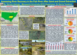
1. Assessing River Recovery in the Fish River After Sand and Gravel Extraction
By: Kerwin Abinoja – Macquarie University 2015 (Supervisor: Dr Kerrie Tomkins)
Introduction:
The Fish River is a partly-confined low sinuosity laterally
meandering river channel1. It is situated in the Macquarie
catchment within the Murray-Darling basin and located
in the Central Western Region of NSW, Australia2 (Figure
1). It starts at an elevation of 1,160m below Charlies Hill2.
Figure 1 showing the location of the Fish River (black) located
within the Central Western Region (yellow) of NSW (green)
Background:
Sand and gravel extraction in the Fish River began as a
Rivercare ‘stream clearance’ project which aimed to
extract some of the sand and remove the willows which
had been causing channel blockages within the
channel2. However, it over-extracted sand beyond its
proposed 1m below the channel bed, extracting down
into its gravel bed armour and removing all riparian
vegetation, including important native species2. This
problem is significant as previous studies have
highlighted the negative impacts of unsustainable sand
and gravel mining on rivers, which include the
disruption of the river bed armour leading to bed
degradation, localised channel incision and widening,
severe bank damage and erosion, degradation of native
riparian vegetation, fauna, and habitats, and
deterioration of instream/groundwater quality3,4,5,6,7,8,9,10.
This issue is particularly significant to the Fish River
because it is a ‘sediment-starved’ river system, in which
sediment stores on the valley floors are the primary
component of post-disturbance sediment3. This means
that sediments in the Fish River have a higher likelihood
of being removed or re-worked after river mining without
being replenished readily, making it more prone to river
degradation due to its lower rate of recovery in terms of
geomorphic replenishment. The natural rate of recovery
in the Fish River is therefore worth investigating.
Research Objective:
To collect and comparatively analyse geomorphic and
vegetation data from degraded and intact reaches of the
Fish River to determine whether the degraded reaches
have substantially recovered 10 years after sand and
gravel extraction in terms of geomorphic landform
development and/or riparian vegetation characteristics.
This research contributes to the study of river recovery.
Methods:
1) An aerial map of the Fish River was used to identify degraded & intact reaches.
2) Reaches with signs of degradation were selected to represent degraded
reaches while reaches further upstream near Evans Crown Nature Reserve
were selected to represent intact reaches due to it being a nature reserve and
therefore no human disturbance would have preserved these intact reaches.
3) Channel size surveys were conducted on two degraded reaches and compared
to earlier channel size measurements taken in 2001 from similar locations.
4) Visual observations were made on the geomorphic landforms and riparian
vegetation characteristics of degraded and intact reaches. Manning’s n
coefficient for riparian vegetation was also used to assess vegetation density.
Fish River
Study Sites:
Figure 1
Upstream
Downstream
Flow Direction
Upstream
Figure 2: Locations
of selected
representative
reaches in the Fish
River.
Degraded reaches
(left) and intact
reaches (below)
Fish River
D 2
D 1
D 3
D 4
D 5
D 6
U 1
U 2
Figure 6 (top left) showing a mid-
channel bar forming in D4.
Figure 7 (top right) showing a
longitudinal bar forming in D5.
Figure 8 showing a dense cover
of casuarinas and the common
reed with negligible willow growth
in D6 indicating significant
vegetation recovery in this reach.
Figure 9 showing a dense cover
of wattles and common reeds
with no willow growth in U2.
Results and Discussion:
Channel Size and Geomorphic Units:
Channel survey results show that D4 had experienced a
2m channel contraction and D5 experienced a 1m channel
contraction (Figure 5). This indicates that to some extent,
geomorphic recovery after sand and gravel extraction has
occurred, manifested in sediment build up and resulted in
channel contraction over 10 years after river mining
activities stopped in 2005. Sedimentation in these
degraded reaches is also evident from the gradual build
up of a mid-channel bar in D4 (Figure 6) and a longitudinal
bar in D5 (Figure 7). In other degraded reaches there were
instream geomorphic units such as point bars, pools &
riffles, eddies, and small bars, which are all indicative of
geomorphic recovery. However, a 2m and 1m channel
contraction over 10 years, the absence of bench
formations, and the lack of channels with suspended or
mixed-load substrate and cohesive fine-grained banks
and floodplains in degraded reaches also indicates that
geomorphic recovery is a very slow process with limited
short-term impact. This is particularly the case when the
sediment budget is modified11, such as in the Fish River.
Figure 5 showing channel widths of D4 and
D5 reaches for 20012 and 2015.
Riparian Vegetation: Density
Manning’s n coefficient (vegetation) results in Figure 9
(below) show that the degraded reaches (D1 – D6) and the
intact reaches (U1 & U2) did not have a significant
difference in total vegetation density, recording
vegetation density scores of between 0.068 – 0.095. This
indicates that riparian vegetation in degraded reaches has
recovered to a significant extent after river mining had
ceased. This is because the initial recovery of riparian
vegetation can easily trigger a positive feedback – it
increases surface roughness which increases
sedimentation by more readily trapping transported
sediments which then creates more suitable conditions
for further plant colonisation and establishment12. The
establishment riparian vegetation is a major factor in river
recovery as riparian vegetation and woody debris
increases the narrowing of channels, stabilises banks and
floodplains, and reinforces the geomorphological units
within the channel13,14,15. Therefore, geomorphic recovery
is intrinsically linked to riparian vegetation recovery.
Downstream
Figure 5
Figure 2
Figure 6: D4 Figure 7: D5
Conclusion: (1) Geomorphic recovery is a very slow process. It would require hundreds to thousands of
years for sediments in the Fish River to be completely replenished and be utilised for long-term geomorphic
recovery. (2) Riparian vegetation recovery occurs at a much faster rate – over decadal timescales. However, the
type of riparian plant species and the rate of disturbance at different locations will influence recovery rates.
(3) Vegetation recovery and geomorphic recovery are interlinked through increasing roughness in river systems.
Figure 9
D 5
D 6
Figure 8: D6
Bosworth Falls
Figure 9: U2
Riparian Vegetation: Composition
Figures 8 – 12 show that reaches in
different locations have varying riparian
vegetation composition. Casuarinas
decrease while the common reed,
wattle, and grass increase further
upstream. This is because different
riparian species16 and different
disturbance rates17 at different
locations influence vegetation recovery.
Mid-channel bar
Longitudinal bar
Common reed
Casuarina
Wattle
Common reed
Figure 11
Figure 10
Figure 12
2. References
(1) Digital Atlas Pty Limited (2015). ‘Map of Fish River, NSW’. http://www.bonzle.com/c/a?a=p&p=210429&cmd=sp Accessed: 20th November 2015
(2) Tomkins, K. (2015). ‘GSE808 Lecture – Week 5: Overview of the Fish River sand and gravel extraction site’. Department of Environmental Sciences.
Macquarie University.
(3) Fryirs, K. and Brierley, G. J. (2000). ‘Variability in sediment delivery and storage along river courses in Bega catchment, NSW, Australia: implications
for geomorphic river recovery’. Geomorphology. Volume 38. pp. 237 - 265.
(4) McCabe, D. J. and Gotelli, N. J. (2000). ‘Effects of disturbance frequency, intensity, and area on assemblages
of stream macroinvertebrates’. Oecologia. Volume 124. pp. 270 - 279.
(5) Podimata, M. V. and Yannopoulos, P. C. (2015). ‘A conceptual approach to model sand-gravel extraction from rivers based on a game theory
perspective’. Journal of Environmental Planning and Management. pp. 1 - 22.
(6) Liangwen, J., Zhangren, L., Qingshu, Y., Shuying, O., and Yaping, L. (2007). ‘Impacts of the large amount of sand mining on riverbed morphology and
tidal dynamics in lower reaches and delta of the Dongjiang River’. Journal of Geographical Sciences. pp. 197 - 211.
(7) Meador, M. R. and Layher, A. O. (1998). ‘Instream sand and gravel mining: environmental issues and regulatory process in the United States’.
Fisheries. Volume 23. pp. 6 -13.
(8) Mori, N., Simcˇicˇ, T., Lukancˇicˇ, S. and Brancelj, A. (2011). ‘The effect of in-stream gravel extraction in a pre-alpine gravel-bed river on hyporheic
invertebrate community’. Hydrobiologia. Volume 667. pp. 15 - 30.
(9) Boyd, S. E., Limpenny, D. S., Rees, H. L. and Cooper, K. M. (2005). ‘The effects of marine sand and gravel extraction on the macrobenthos at a
commercial dredging site (results 6 years post-dredging)’. ICES Journal of Marine Science. Volume 62. pp. 145 - 162.
(10) Erskine, W. D., Geary, P. M. and Outhet, D. N. (1985). ‘Potential Impacts of Sand and Gravel Extraction on
the Hunter River, New South Wales. Australian Geographical Studies. Volume 23. pp. 71 - 86.
(11) Brierley, G. J., Cohens, T., Fryirs K., and Brooks, A. (1999). ‘Post-European changes to the fluvial geomorphology of Bega catchment, Australia:
implications for river ecology’. Freshwater Biology. Volume 41. pp. 839 - 848.
(12) Hoffman, M. T. and Rohde, R. F. (2011). ‘Rivers Through Time: Historical Changes in the Riparian Vegetation of the Semi-Arid, Winter Rainfall Region
of South Africa in Response to Climate and Land Use’. Journal of the History of Biology. Volume 44. pp. 59 - 80.
(13) Steiger, J. and Gurnell, A. M. (2002). ‘Spatial hydrogeomorphological influences on sediment and nutrient deposition in riparian zones: observations
from the Garonne River, France’. Geomorphology. Volume 49. pp. 1 - 23.
(14) Takahashi, M. and Nakamura, F. (2011). ‘Impacts of dam-regulated flows on channel morphology and riparian vegetation: a longitudinal analysis of
Satsunai River, Japan’. Landscape Ecol Eng. Volume 7. pp. 65 - 77.
(15) Brooks, A. P., Brierley, G. J. and Millar, R. G. (2003). ‘The long-term control of vegetation and woody debris on channel and flood-plain evolution:
insights from a paired catchment study in south-eastern Australia’. Geomorphology. Volume 51. pp. 7 - 29.
(16) Salinas, M. J. and Casas, J. J. (2007). ‘Riparian Vegetation of Two Semi-Arid Mediterranean Rivers: Basin-Scale Responses of Woody and
Herbaceous Plants to Environmental Gradients’. Wetlands. Volume 27. Number 4. pp. 831 - 845.
(17) Barrat-Segretain, M. H. and Amoros, C. (1995). ‘Recovery of riverine vegetation after experimental disturbance: a field test of the patch dynamics
concept’. Hydrobiologia. Volume 321. pp. 53 - 68.