SlideShare a Scribd company logo
1 of 4
Download to read offline
International Research Journal of Engineering and Technology (IRJET) e-ISSN: 2395-0056
Volume: 09 Issue: 04 | Apr 2022 www.irjet.net p-ISSN: 2395-0072
© 2022, IRJET | Impact Factor value: 7.529 | ISO 9001:2008 Certified Journal | Page 2705
Accuracy Assessment of Land Use/Land Cover Classification using
multi temporal images and Geo-spatial techniques for Varanasi city
Vandana Gupta1, Shri Arjun Singh2
1M.Tech in RS & GIS , RSAC-UP, Lucknow, Uttar Pradesh, India
2Scientist-SD, RSAC-UP, Lucknow, Uttar Pradesh, India
---------------------------------------------------------------------***---------------------------------------------------------------------
Abstract – Land Use Land Cover (LULC) change
detection study helps to understand the environmental
change dynamics to ensure sustainable development. Land
cover is what covers the surface of the earth and land
use describes how the land is used. This study mainly focuses
on the usage of the geographic information system (GIS)
and land usage to identify the changes in Varanasi city,
which is located in Uttar Pradesh, India. GIS technique
provides reliable accurate information for land use mapping
through Landsat satellite imagery because it provides a
synoptic view. The present study is focused on defining
boundaries of different land use / land cover on a landsat
satellite Imagery using Erdas Imagine 14 software. The
work is done by visual image interpretation. This study
mainly focuses on the classification and identification of the
changes in Land use/Land cover in the years 2000, 2010 &
2020 based on a multi temporal images gathered from the
satellite. The experimental results indicate that over the
specified period of study, the rate of increment and
decrement in the built-up area, water bodies, crop land,
vegetation, fallow land and sandbars that may exhibit a
significant impact on the environmental ecosystem and
sustainable development.
Key Words: Land use Land cover, Change detection,
Landsat.
1. INTRODUCTION
Land use/land cover (LULC) changes play an significant
role in monitoring the changes at local, regional, and
national level (Gupta & Munshi, 1985; Mas, 1999). Land
cover is what covers the surface of the earth and land
use describes how the land is used. Since the past 100
years, the human population and its influence have
increased exponentially on land. Human migrations on the
Earth’s surface result in changes in the land cover. These
changes considerably affect key features of Earth system
functioning. Moreover, population is growing rapidly, far
out spacing the ability of our planet to support it , it
continues to be a major underlying force of environmental
degradation and a threat to sustainable use of natural
resources , which is caused by an increase in population,
impact the land use/land cover changes (Islam et al.,
2018).
The main purpose of LULC classification and change
detection in GIS include discriminating the geographical
features and sort of changes, admeasure the changes and
estimate the accuracy assessment results by using kappa
statistics(Coppin et al., 2004; Im & Jensen, 2005).
Landsat data sets has been downloaded from the online
poartal of United States Geological Survey (USGS) Earth
Explorer free of cost (http://earthexplorer.usgs.gov) .
2. STUDY AREA
This study is done on Varanasi which is located in the
north Indian state of Uttar Pradesh. It is also called Kashi.
According to Hindu and Buddhist mythologies, it is one of
the sacred places of pilgrimage for Hindus and Buddhists.
It is believed that Lord Shiva along with Parvathi as
Vishwanatha and Vishalaakshi reside there to bless
devotees. It is surrounded by Mirzapur district, Jaunpur
district, Ghazipur district, Chandauli district, and Bhadohi
district. The Ganga (Ganges) river flows through the
district. It is considered by Hindus to be a sacred and pure
river, having the ability to wash away sins when people
take a dip in it. Location map of the study area is shown in
the Fig. 1.
Fig-1: Location map of Study Area
International Research Journal of Engineering and Technology (IRJET) e-ISSN: 2395-0056
Volume: 09 Issue: 04 | Apr 2022 www.irjet.net p-ISSN: 2395-0072
© 2022, IRJET | Impact Factor value: 7.529 | ISO 9001:2008 Certified Journal | Page 2706
3. DATA USED AND METHODOLOGY:
Landsat satellite imageries datasets have been used in the
study. In this study, LULC were prepared from Landsat
data at decadal interval in ERDAS IMAGINE 14. Landsat-7
ETM+ (2000), Landsat-5 TM (2010) and Landsat-OLI
(2020) were downloaded from the U.S. Geological Survey
(www.usgs.gov.in). Then, all bands of datasets were
stacked as a single image for each scene. Thereafter,
imageries were projected in UTM projection system
(datum WGS 1984, 44 N zone). Before the supervised
classification, the dataset were masked for the study area.
Details of Landsat images used in the study are given in
the Table 1.
Table1:- Details of Landsat images used in the study.
Accuracy assessment is used to assess the quality of the
information of LU/LC maps generated from the google
earth pro data. The confusion matrices has been plotted as
cross‐tabulations of information obtained from classified
maps versus the google earth pro data. Hence, overall
accuracy, user’s and producer’s accuracies and the kappa
statistic were estimated from the confusion matrices(Liu &
Mason, 2009).
The overall accuracy is estimated by taking the ratio
between sum of the major diagonal elements and the total
number of pixels (N). The following equation used for
determination of user’s accuracy, producer’s accuracy and
kappa coefficient (k):
User’s accuracy = Cii/Nri
Producer’s accuracy = Cii/Ncj
where,Nri is sum of any row i and Ncj is sum of any
column j in the confusion matrix.
2.3. Methodology adopted for this analysis
Flowchart for the Land use/ land cover changes and
change detection methodology have been shown in figure
2.
Fig-2:Flowchart of the methodology.
4. RESULTS AND DISCUSSIONS:
The whole study area has been classified into six classes.
Land use land cover (LULC) maps prepared at decadal
interval and there has been a positive and negative
variation in each category at each decadal interval. The
area falling under each category for different five years
(2000, 2010, 2020) has been given in table 1.
There has been gradual decrease in area of water bodies in
each decadal year. The fallow land area has increased 3.27
% in the year 2010, and again increased 2.4 % in the year
2020. The crop land area has increased by 3.58% in 2010
and then decreased by 14.22% in 2020. There is not very
S.NO. Satellite
data
DATE PATH/ROW
1. Landsat-8 02/04/2020 142/42
142/43
2. Landsat-5 25/05/2010 142/42
142/43
3. Landsat-7 03/04/2000 142/42
142/43
Train the data by using visual
interpretation method.
Supervised classification by using
maximum likelihood algorithm
Generate the confusion matrix &
Accuracy assessment analysis
Results and discussion
Generate the attribute table
LULC map of the year 2000,
2010 and 2020
Satellite Data
Image pre-processing
International Research Journal of Engineering and Technology (IRJET) e-ISSN: 2395-0056
Volume: 09 Issue: 04 | Apr 2022 www.irjet.net p-ISSN: 2395-0072
© 2022, IRJET | Impact Factor value: 7.529 | ISO 9001:2008 Certified Journal | Page 2707
remarkable change in the area of sand bars. The area of
vegetation has reduced by 8.05% in 2010 and increased
by 4.66% in 2020. In 2000, the built up area was 3.62 %
while it is 11.66 % of total area in 2020. It means that the
built up land has increased in due respect of time. The
maximum changes have been seen in the data depicting
settlements and roads. The changes in settlements are
found mainly in the area around Varanasi city and its
surroundings.
The LULC classes of Varanasi district during different time
periods are shown in the Fig. 3 (a-c). The area distribution
and changes in LULC classes are given Table 2 and 3 .
Table 2: LandUse /Land Cover Area distribution.
LULC classes AREA(%)
2000
AREA(%)
2010
AREA(%)
2020
WATER
BODIES
1.35 1.11 1.76
SANDBARS 1.17 1.13 1.03
FALLOW LAND 7.66 10.93 13.38
BUILT UP
AREA
3.62 5.1 11.66
VEGETATION 12.98 4.93 9.59
CROP LAND 73.22 76.8 62.58
TOTAL 100 100 100
Table 3: Changes in LULC during 2000–2010 and
2010-2020
CHAGES IN
AREA(%)
Period/LULC
Classes
2000-2010 2010-2020
WATER BODIES -0.24 0.65
SANDBARS -0.04 -0.1
FALLOW LAND 3.27 2.45
BUILT UP AREA 1.48 6.56
VEGETATION -8.05 4.66
CROP LAND 3.58 -14.22
Note: Positive (+) value indicate gain in the area whereas
negative (-) value indicate loss in area .
Fig-3:LULC classes of Varanasi in (a)2000, (b)2010
& (c)2020
The google earth pro data is used as the reference for
assessing the accuracy of classification. The accuracy and
KAPPA statistics of the classified image checked with the
help of accuracy assessment by confusion matrix
preparation. The overall accuracy of the image is given in
the Table 4.
Table 4: Overall accuracy of classified images of
different years
YEAR Overall Accuracy KAPPA Statistics
2000 93.94% 92.66%
2010 91.66% 89.89%
2020 89.47% 86.44%
5. CONCLUSIONS
In this study , GIS is used for understanding the LULC
changes in Varanasi city over 20 years from 2000 to 2020.
The technique used in this study is simple and
inexpensive. The extent of land-use changes was
determined using multitemporal Landsat satellite imagery.
In this study, accuracy assessment analysis is done by
using the confusion matrix. Significant changes in the
LULC were observed in the study area between 2000 and
2020.
During these 20 years, It is apparent that urban expansion
is maximum than all the other land classifications. In short,
International Research Journal of Engineering and Technology (IRJET) e-ISSN: 2395-0056
Volume: 09 Issue: 04 | Apr 2022 www.irjet.net p-ISSN: 2395-0072
© 2022, IRJET | Impact Factor value: 7.529 | ISO 9001:2008 Certified Journal | Page 2708
the results have shown that there is a significant increase
in urban expansion leading to a significant drop in crop
land use and vegetation during the study period.
REFERENCES
[1] Gupta, D. M., & Munshi, M. K. (1985). Urban
change detection and land-use mapping of Delhi.
International Journal of Remote Sensing, 6(3–4),
529–534.
https://doi.org/10.1080/01431168508948474
[2] Islam, K., Jashimuddin, M., Nath, B., & Nath, T. K.
(2018). Land use classification and change
detection by using multi-temporal remotely
sensed imagery: The case of Chunati wildlife
sanctuary, Bangladesh. The Egyptian Journal of
Remote Sensing and Space Sciences, 21(1), 37–47.
https://doi.org/10.1016/j.ejrs.2016.12.005
[3] Coppin, P., Jonckheere, I., Nackaerts, K., Muys, B.
&Lambin, E. (2004). Review article digital change
detection methods in ecosystem monitoring: a
review. International Journal of Remote Sensing
25:1565–1596.
[4] Liu J.G. & Mason, P.J, (2009). Essential Image
Processing and GIS for Remote Sensing. John Wiley
& Sons, Inc.

More Related Content

Similar to Accuracy Assessment of Land Use/Land Cover Classification using multi temporal images and Geo-spatial techniques for Varanasi city

ASSESSMENT OF URBAN DYNAMICS IN LAND USE AND DEMOGRPAHY USING GIS TECHNIQUES
ASSESSMENT OF URBAN DYNAMICS IN LAND USE AND DEMOGRPAHY USING GIS TECHNIQUESASSESSMENT OF URBAN DYNAMICS IN LAND USE AND DEMOGRPAHY USING GIS TECHNIQUES
ASSESSMENT OF URBAN DYNAMICS IN LAND USE AND DEMOGRPAHY USING GIS TECHNIQUESIRJET Journal
 
Land Use/Land Cover Mapping Of Allahabad City by Using Remote Sensing & GIS
Land Use/Land Cover Mapping Of Allahabad City by Using  Remote Sensing & GIS Land Use/Land Cover Mapping Of Allahabad City by Using  Remote Sensing & GIS
Land Use/Land Cover Mapping Of Allahabad City by Using Remote Sensing & GIS IJMER
 
Paper id 71201910
Paper id 71201910Paper id 71201910
Paper id 71201910IJRAT
 
MONITORING OF WETLANDS IN PANDU RIVER SUBWATERSHED UTTAR PRADESH USING REMOTE...
MONITORING OF WETLANDS IN PANDU RIVER SUBWATERSHED UTTAR PRADESH USING REMOTE...MONITORING OF WETLANDS IN PANDU RIVER SUBWATERSHED UTTAR PRADESH USING REMOTE...
MONITORING OF WETLANDS IN PANDU RIVER SUBWATERSHED UTTAR PRADESH USING REMOTE...IRJET Journal
 
Classification of aurangabad city using high resolution remote sensing data
Classification of aurangabad city using high resolution remote sensing dataClassification of aurangabad city using high resolution remote sensing data
Classification of aurangabad city using high resolution remote sensing dataeSAT Journals
 
Land use/land cover classification using machine learning models
Land use/land cover classification using machine learning  modelsLand use/land cover classification using machine learning  models
Land use/land cover classification using machine learning modelsIJECEIAES
 
IRJET- Use Geotechnical to Analyze Agricultural use Changes to Support Urban ...
IRJET- Use Geotechnical to Analyze Agricultural use Changes to Support Urban ...IRJET- Use Geotechnical to Analyze Agricultural use Changes to Support Urban ...
IRJET- Use Geotechnical to Analyze Agricultural use Changes to Support Urban ...IRJET Journal
 
Analysis of Land Use Land Cover Change and Relative Growth in Social Amenitie...
Analysis of Land Use Land Cover Change and Relative Growth in Social Amenitie...Analysis of Land Use Land Cover Change and Relative Growth in Social Amenitie...
Analysis of Land Use Land Cover Change and Relative Growth in Social Amenitie...IRJET Journal
 
IRJET- Land Cover Index Classification using Satellite Images with Different ...
IRJET- Land Cover Index Classification using Satellite Images with Different ...IRJET- Land Cover Index Classification using Satellite Images with Different ...
IRJET- Land Cover Index Classification using Satellite Images with Different ...IRJET Journal
 
IRJET - Digitization of Master Plan Map and Preparation of Different Them...
IRJET -  	  Digitization of Master Plan Map and Preparation of Different Them...IRJET -  	  Digitization of Master Plan Map and Preparation of Different Them...
IRJET - Digitization of Master Plan Map and Preparation of Different Them...IRJET Journal
 
The International Journal of Engineering and Science (The IJES)
The International Journal of Engineering and Science (The IJES)The International Journal of Engineering and Science (The IJES)
The International Journal of Engineering and Science (The IJES)theijes
 
Review Paper: Analysis of Landslide Hazard Zones (Hotspots) & Mitigation in W...
Review Paper: Analysis of Landslide Hazard Zones (Hotspots) & Mitigation in W...Review Paper: Analysis of Landslide Hazard Zones (Hotspots) & Mitigation in W...
Review Paper: Analysis of Landslide Hazard Zones (Hotspots) & Mitigation in W...IRJET Journal
 
IRJET- Impact Assessment of Mining Activities through Change Detection Analysis
IRJET- Impact Assessment of Mining Activities through Change Detection AnalysisIRJET- Impact Assessment of Mining Activities through Change Detection Analysis
IRJET- Impact Assessment of Mining Activities through Change Detection AnalysisIRJET Journal
 
IRJET - Decadal Sodic Land Change in Bewar Branch Canal Command using Isodata...
IRJET - Decadal Sodic Land Change in Bewar Branch Canal Command using Isodata...IRJET - Decadal Sodic Land Change in Bewar Branch Canal Command using Isodata...
IRJET - Decadal Sodic Land Change in Bewar Branch Canal Command using Isodata...IRJET Journal
 
IRJET- Use of Landsat ETM+ Data for Delineation of Vegetation Cover Area in A...
IRJET- Use of Landsat ETM+ Data for Delineation of Vegetation Cover Area in A...IRJET- Use of Landsat ETM+ Data for Delineation of Vegetation Cover Area in A...
IRJET- Use of Landsat ETM+ Data for Delineation of Vegetation Cover Area in A...IRJET Journal
 
“Cadastral Maps for Socio-Economic Data Visualization and Integration for Lan...
“Cadastral Maps for Socio-Economic Data Visualization and Integration for Lan...“Cadastral Maps for Socio-Economic Data Visualization and Integration for Lan...
“Cadastral Maps for Socio-Economic Data Visualization and Integration for Lan...irjes
 

Similar to Accuracy Assessment of Land Use/Land Cover Classification using multi temporal images and Geo-spatial techniques for Varanasi city (20)

ASSESSMENT OF URBAN DYNAMICS IN LAND USE AND DEMOGRPAHY USING GIS TECHNIQUES
ASSESSMENT OF URBAN DYNAMICS IN LAND USE AND DEMOGRPAHY USING GIS TECHNIQUESASSESSMENT OF URBAN DYNAMICS IN LAND USE AND DEMOGRPAHY USING GIS TECHNIQUES
ASSESSMENT OF URBAN DYNAMICS IN LAND USE AND DEMOGRPAHY USING GIS TECHNIQUES
 
Land Use/Land Cover Mapping Of Allahabad City by Using Remote Sensing & GIS
Land Use/Land Cover Mapping Of Allahabad City by Using  Remote Sensing & GIS Land Use/Land Cover Mapping Of Allahabad City by Using  Remote Sensing & GIS
Land Use/Land Cover Mapping Of Allahabad City by Using Remote Sensing & GIS
 
Paper id 71201910
Paper id 71201910Paper id 71201910
Paper id 71201910
 
MONITORING OF WETLANDS IN PANDU RIVER SUBWATERSHED UTTAR PRADESH USING REMOTE...
MONITORING OF WETLANDS IN PANDU RIVER SUBWATERSHED UTTAR PRADESH USING REMOTE...MONITORING OF WETLANDS IN PANDU RIVER SUBWATERSHED UTTAR PRADESH USING REMOTE...
MONITORING OF WETLANDS IN PANDU RIVER SUBWATERSHED UTTAR PRADESH USING REMOTE...
 
Classification of aurangabad city using high resolution remote sensing data
Classification of aurangabad city using high resolution remote sensing dataClassification of aurangabad city using high resolution remote sensing data
Classification of aurangabad city using high resolution remote sensing data
 
Land use/land cover classification using machine learning models
Land use/land cover classification using machine learning  modelsLand use/land cover classification using machine learning  models
Land use/land cover classification using machine learning models
 
IRJET- Use Geotechnical to Analyze Agricultural use Changes to Support Urban ...
IRJET- Use Geotechnical to Analyze Agricultural use Changes to Support Urban ...IRJET- Use Geotechnical to Analyze Agricultural use Changes to Support Urban ...
IRJET- Use Geotechnical to Analyze Agricultural use Changes to Support Urban ...
 
Analysis of Land Use Land Cover Change and Relative Growth in Social Amenitie...
Analysis of Land Use Land Cover Change and Relative Growth in Social Amenitie...Analysis of Land Use Land Cover Change and Relative Growth in Social Amenitie...
Analysis of Land Use Land Cover Change and Relative Growth in Social Amenitie...
 
Research paper
Research paperResearch paper
Research paper
 
IRJET- Land Cover Index Classification using Satellite Images with Different ...
IRJET- Land Cover Index Classification using Satellite Images with Different ...IRJET- Land Cover Index Classification using Satellite Images with Different ...
IRJET- Land Cover Index Classification using Satellite Images with Different ...
 
IRJET - Digitization of Master Plan Map and Preparation of Different Them...
IRJET -  	  Digitization of Master Plan Map and Preparation of Different Them...IRJET -  	  Digitization of Master Plan Map and Preparation of Different Them...
IRJET - Digitization of Master Plan Map and Preparation of Different Them...
 
The International Journal of Engineering and Science (The IJES)
The International Journal of Engineering and Science (The IJES)The International Journal of Engineering and Science (The IJES)
The International Journal of Engineering and Science (The IJES)
 
1. mohammed aslam, b. mahalingam
1. mohammed aslam,  b. mahalingam1. mohammed aslam,  b. mahalingam
1. mohammed aslam, b. mahalingam
 
Review Paper: Analysis of Landslide Hazard Zones (Hotspots) & Mitigation in W...
Review Paper: Analysis of Landslide Hazard Zones (Hotspots) & Mitigation in W...Review Paper: Analysis of Landslide Hazard Zones (Hotspots) & Mitigation in W...
Review Paper: Analysis of Landslide Hazard Zones (Hotspots) & Mitigation in W...
 
Ar24289294
Ar24289294Ar24289294
Ar24289294
 
IRJET- Impact Assessment of Mining Activities through Change Detection Analysis
IRJET- Impact Assessment of Mining Activities through Change Detection AnalysisIRJET- Impact Assessment of Mining Activities through Change Detection Analysis
IRJET- Impact Assessment of Mining Activities through Change Detection Analysis
 
IRJET - Decadal Sodic Land Change in Bewar Branch Canal Command using Isodata...
IRJET - Decadal Sodic Land Change in Bewar Branch Canal Command using Isodata...IRJET - Decadal Sodic Land Change in Bewar Branch Canal Command using Isodata...
IRJET - Decadal Sodic Land Change in Bewar Branch Canal Command using Isodata...
 
abstract review1 (C1)2.pptx
abstract review1 (C1)2.pptxabstract review1 (C1)2.pptx
abstract review1 (C1)2.pptx
 
IRJET- Use of Landsat ETM+ Data for Delineation of Vegetation Cover Area in A...
IRJET- Use of Landsat ETM+ Data for Delineation of Vegetation Cover Area in A...IRJET- Use of Landsat ETM+ Data for Delineation of Vegetation Cover Area in A...
IRJET- Use of Landsat ETM+ Data for Delineation of Vegetation Cover Area in A...
 
“Cadastral Maps for Socio-Economic Data Visualization and Integration for Lan...
“Cadastral Maps for Socio-Economic Data Visualization and Integration for Lan...“Cadastral Maps for Socio-Economic Data Visualization and Integration for Lan...
“Cadastral Maps for Socio-Economic Data Visualization and Integration for Lan...
 

More from IRJET Journal

TUNNELING IN HIMALAYAS WITH NATM METHOD: A SPECIAL REFERENCES TO SUNGAL TUNNE...
TUNNELING IN HIMALAYAS WITH NATM METHOD: A SPECIAL REFERENCES TO SUNGAL TUNNE...TUNNELING IN HIMALAYAS WITH NATM METHOD: A SPECIAL REFERENCES TO SUNGAL TUNNE...
TUNNELING IN HIMALAYAS WITH NATM METHOD: A SPECIAL REFERENCES TO SUNGAL TUNNE...IRJET Journal
 
STUDY THE EFFECT OF RESPONSE REDUCTION FACTOR ON RC FRAMED STRUCTURE
STUDY THE EFFECT OF RESPONSE REDUCTION FACTOR ON RC FRAMED STRUCTURESTUDY THE EFFECT OF RESPONSE REDUCTION FACTOR ON RC FRAMED STRUCTURE
STUDY THE EFFECT OF RESPONSE REDUCTION FACTOR ON RC FRAMED STRUCTUREIRJET Journal
 
A COMPARATIVE ANALYSIS OF RCC ELEMENT OF SLAB WITH STARK STEEL (HYSD STEEL) A...
A COMPARATIVE ANALYSIS OF RCC ELEMENT OF SLAB WITH STARK STEEL (HYSD STEEL) A...A COMPARATIVE ANALYSIS OF RCC ELEMENT OF SLAB WITH STARK STEEL (HYSD STEEL) A...
A COMPARATIVE ANALYSIS OF RCC ELEMENT OF SLAB WITH STARK STEEL (HYSD STEEL) A...IRJET Journal
 
Effect of Camber and Angles of Attack on Airfoil Characteristics
Effect of Camber and Angles of Attack on Airfoil CharacteristicsEffect of Camber and Angles of Attack on Airfoil Characteristics
Effect of Camber and Angles of Attack on Airfoil CharacteristicsIRJET Journal
 
A Review on the Progress and Challenges of Aluminum-Based Metal Matrix Compos...
A Review on the Progress and Challenges of Aluminum-Based Metal Matrix Compos...A Review on the Progress and Challenges of Aluminum-Based Metal Matrix Compos...
A Review on the Progress and Challenges of Aluminum-Based Metal Matrix Compos...IRJET Journal
 
Dynamic Urban Transit Optimization: A Graph Neural Network Approach for Real-...
Dynamic Urban Transit Optimization: A Graph Neural Network Approach for Real-...Dynamic Urban Transit Optimization: A Graph Neural Network Approach for Real-...
Dynamic Urban Transit Optimization: A Graph Neural Network Approach for Real-...IRJET Journal
 
Structural Analysis and Design of Multi-Storey Symmetric and Asymmetric Shape...
Structural Analysis and Design of Multi-Storey Symmetric and Asymmetric Shape...Structural Analysis and Design of Multi-Storey Symmetric and Asymmetric Shape...
Structural Analysis and Design of Multi-Storey Symmetric and Asymmetric Shape...IRJET Journal
 
A Review of “Seismic Response of RC Structures Having Plan and Vertical Irreg...
A Review of “Seismic Response of RC Structures Having Plan and Vertical Irreg...A Review of “Seismic Response of RC Structures Having Plan and Vertical Irreg...
A Review of “Seismic Response of RC Structures Having Plan and Vertical Irreg...IRJET Journal
 
A REVIEW ON MACHINE LEARNING IN ADAS
A REVIEW ON MACHINE LEARNING IN ADASA REVIEW ON MACHINE LEARNING IN ADAS
A REVIEW ON MACHINE LEARNING IN ADASIRJET Journal
 
Long Term Trend Analysis of Precipitation and Temperature for Asosa district,...
Long Term Trend Analysis of Precipitation and Temperature for Asosa district,...Long Term Trend Analysis of Precipitation and Temperature for Asosa district,...
Long Term Trend Analysis of Precipitation and Temperature for Asosa district,...IRJET Journal
 
P.E.B. Framed Structure Design and Analysis Using STAAD Pro
P.E.B. Framed Structure Design and Analysis Using STAAD ProP.E.B. Framed Structure Design and Analysis Using STAAD Pro
P.E.B. Framed Structure Design and Analysis Using STAAD ProIRJET Journal
 
A Review on Innovative Fiber Integration for Enhanced Reinforcement of Concre...
A Review on Innovative Fiber Integration for Enhanced Reinforcement of Concre...A Review on Innovative Fiber Integration for Enhanced Reinforcement of Concre...
A Review on Innovative Fiber Integration for Enhanced Reinforcement of Concre...IRJET Journal
 
Survey Paper on Cloud-Based Secured Healthcare System
Survey Paper on Cloud-Based Secured Healthcare SystemSurvey Paper on Cloud-Based Secured Healthcare System
Survey Paper on Cloud-Based Secured Healthcare SystemIRJET Journal
 
Review on studies and research on widening of existing concrete bridges
Review on studies and research on widening of existing concrete bridgesReview on studies and research on widening of existing concrete bridges
Review on studies and research on widening of existing concrete bridgesIRJET Journal
 
React based fullstack edtech web application
React based fullstack edtech web applicationReact based fullstack edtech web application
React based fullstack edtech web applicationIRJET Journal
 
A Comprehensive Review of Integrating IoT and Blockchain Technologies in the ...
A Comprehensive Review of Integrating IoT and Blockchain Technologies in the ...A Comprehensive Review of Integrating IoT and Blockchain Technologies in the ...
A Comprehensive Review of Integrating IoT and Blockchain Technologies in the ...IRJET Journal
 
A REVIEW ON THE PERFORMANCE OF COCONUT FIBRE REINFORCED CONCRETE.
A REVIEW ON THE PERFORMANCE OF COCONUT FIBRE REINFORCED CONCRETE.A REVIEW ON THE PERFORMANCE OF COCONUT FIBRE REINFORCED CONCRETE.
A REVIEW ON THE PERFORMANCE OF COCONUT FIBRE REINFORCED CONCRETE.IRJET Journal
 
Optimizing Business Management Process Workflows: The Dynamic Influence of Mi...
Optimizing Business Management Process Workflows: The Dynamic Influence of Mi...Optimizing Business Management Process Workflows: The Dynamic Influence of Mi...
Optimizing Business Management Process Workflows: The Dynamic Influence of Mi...IRJET Journal
 
Multistoried and Multi Bay Steel Building Frame by using Seismic Design
Multistoried and Multi Bay Steel Building Frame by using Seismic DesignMultistoried and Multi Bay Steel Building Frame by using Seismic Design
Multistoried and Multi Bay Steel Building Frame by using Seismic DesignIRJET Journal
 
Cost Optimization of Construction Using Plastic Waste as a Sustainable Constr...
Cost Optimization of Construction Using Plastic Waste as a Sustainable Constr...Cost Optimization of Construction Using Plastic Waste as a Sustainable Constr...
Cost Optimization of Construction Using Plastic Waste as a Sustainable Constr...IRJET Journal
 

More from IRJET Journal (20)

TUNNELING IN HIMALAYAS WITH NATM METHOD: A SPECIAL REFERENCES TO SUNGAL TUNNE...
TUNNELING IN HIMALAYAS WITH NATM METHOD: A SPECIAL REFERENCES TO SUNGAL TUNNE...TUNNELING IN HIMALAYAS WITH NATM METHOD: A SPECIAL REFERENCES TO SUNGAL TUNNE...
TUNNELING IN HIMALAYAS WITH NATM METHOD: A SPECIAL REFERENCES TO SUNGAL TUNNE...
 
STUDY THE EFFECT OF RESPONSE REDUCTION FACTOR ON RC FRAMED STRUCTURE
STUDY THE EFFECT OF RESPONSE REDUCTION FACTOR ON RC FRAMED STRUCTURESTUDY THE EFFECT OF RESPONSE REDUCTION FACTOR ON RC FRAMED STRUCTURE
STUDY THE EFFECT OF RESPONSE REDUCTION FACTOR ON RC FRAMED STRUCTURE
 
A COMPARATIVE ANALYSIS OF RCC ELEMENT OF SLAB WITH STARK STEEL (HYSD STEEL) A...
A COMPARATIVE ANALYSIS OF RCC ELEMENT OF SLAB WITH STARK STEEL (HYSD STEEL) A...A COMPARATIVE ANALYSIS OF RCC ELEMENT OF SLAB WITH STARK STEEL (HYSD STEEL) A...
A COMPARATIVE ANALYSIS OF RCC ELEMENT OF SLAB WITH STARK STEEL (HYSD STEEL) A...
 
Effect of Camber and Angles of Attack on Airfoil Characteristics
Effect of Camber and Angles of Attack on Airfoil CharacteristicsEffect of Camber and Angles of Attack on Airfoil Characteristics
Effect of Camber and Angles of Attack on Airfoil Characteristics
 
A Review on the Progress and Challenges of Aluminum-Based Metal Matrix Compos...
A Review on the Progress and Challenges of Aluminum-Based Metal Matrix Compos...A Review on the Progress and Challenges of Aluminum-Based Metal Matrix Compos...
A Review on the Progress and Challenges of Aluminum-Based Metal Matrix Compos...
 
Dynamic Urban Transit Optimization: A Graph Neural Network Approach for Real-...
Dynamic Urban Transit Optimization: A Graph Neural Network Approach for Real-...Dynamic Urban Transit Optimization: A Graph Neural Network Approach for Real-...
Dynamic Urban Transit Optimization: A Graph Neural Network Approach for Real-...
 
Structural Analysis and Design of Multi-Storey Symmetric and Asymmetric Shape...
Structural Analysis and Design of Multi-Storey Symmetric and Asymmetric Shape...Structural Analysis and Design of Multi-Storey Symmetric and Asymmetric Shape...
Structural Analysis and Design of Multi-Storey Symmetric and Asymmetric Shape...
 
A Review of “Seismic Response of RC Structures Having Plan and Vertical Irreg...
A Review of “Seismic Response of RC Structures Having Plan and Vertical Irreg...A Review of “Seismic Response of RC Structures Having Plan and Vertical Irreg...
A Review of “Seismic Response of RC Structures Having Plan and Vertical Irreg...
 
A REVIEW ON MACHINE LEARNING IN ADAS
A REVIEW ON MACHINE LEARNING IN ADASA REVIEW ON MACHINE LEARNING IN ADAS
A REVIEW ON MACHINE LEARNING IN ADAS
 
Long Term Trend Analysis of Precipitation and Temperature for Asosa district,...
Long Term Trend Analysis of Precipitation and Temperature for Asosa district,...Long Term Trend Analysis of Precipitation and Temperature for Asosa district,...
Long Term Trend Analysis of Precipitation and Temperature for Asosa district,...
 
P.E.B. Framed Structure Design and Analysis Using STAAD Pro
P.E.B. Framed Structure Design and Analysis Using STAAD ProP.E.B. Framed Structure Design and Analysis Using STAAD Pro
P.E.B. Framed Structure Design and Analysis Using STAAD Pro
 
A Review on Innovative Fiber Integration for Enhanced Reinforcement of Concre...
A Review on Innovative Fiber Integration for Enhanced Reinforcement of Concre...A Review on Innovative Fiber Integration for Enhanced Reinforcement of Concre...
A Review on Innovative Fiber Integration for Enhanced Reinforcement of Concre...
 
Survey Paper on Cloud-Based Secured Healthcare System
Survey Paper on Cloud-Based Secured Healthcare SystemSurvey Paper on Cloud-Based Secured Healthcare System
Survey Paper on Cloud-Based Secured Healthcare System
 
Review on studies and research on widening of existing concrete bridges
Review on studies and research on widening of existing concrete bridgesReview on studies and research on widening of existing concrete bridges
Review on studies and research on widening of existing concrete bridges
 
React based fullstack edtech web application
React based fullstack edtech web applicationReact based fullstack edtech web application
React based fullstack edtech web application
 
A Comprehensive Review of Integrating IoT and Blockchain Technologies in the ...
A Comprehensive Review of Integrating IoT and Blockchain Technologies in the ...A Comprehensive Review of Integrating IoT and Blockchain Technologies in the ...
A Comprehensive Review of Integrating IoT and Blockchain Technologies in the ...
 
A REVIEW ON THE PERFORMANCE OF COCONUT FIBRE REINFORCED CONCRETE.
A REVIEW ON THE PERFORMANCE OF COCONUT FIBRE REINFORCED CONCRETE.A REVIEW ON THE PERFORMANCE OF COCONUT FIBRE REINFORCED CONCRETE.
A REVIEW ON THE PERFORMANCE OF COCONUT FIBRE REINFORCED CONCRETE.
 
Optimizing Business Management Process Workflows: The Dynamic Influence of Mi...
Optimizing Business Management Process Workflows: The Dynamic Influence of Mi...Optimizing Business Management Process Workflows: The Dynamic Influence of Mi...
Optimizing Business Management Process Workflows: The Dynamic Influence of Mi...
 
Multistoried and Multi Bay Steel Building Frame by using Seismic Design
Multistoried and Multi Bay Steel Building Frame by using Seismic DesignMultistoried and Multi Bay Steel Building Frame by using Seismic Design
Multistoried and Multi Bay Steel Building Frame by using Seismic Design
 
Cost Optimization of Construction Using Plastic Waste as a Sustainable Constr...
Cost Optimization of Construction Using Plastic Waste as a Sustainable Constr...Cost Optimization of Construction Using Plastic Waste as a Sustainable Constr...
Cost Optimization of Construction Using Plastic Waste as a Sustainable Constr...
 

Recently uploaded

(PRIYA) Rajgurunagar Call Girls Just Call 7001035870 [ Cash on Delivery ] Pun...
(PRIYA) Rajgurunagar Call Girls Just Call 7001035870 [ Cash on Delivery ] Pun...(PRIYA) Rajgurunagar Call Girls Just Call 7001035870 [ Cash on Delivery ] Pun...
(PRIYA) Rajgurunagar Call Girls Just Call 7001035870 [ Cash on Delivery ] Pun...ranjana rawat
 
Introduction and different types of Ethernet.pptx
Introduction and different types of Ethernet.pptxIntroduction and different types of Ethernet.pptx
Introduction and different types of Ethernet.pptxupamatechverse
 
MANUFACTURING PROCESS-II UNIT-5 NC MACHINE TOOLS
MANUFACTURING PROCESS-II UNIT-5 NC MACHINE TOOLSMANUFACTURING PROCESS-II UNIT-5 NC MACHINE TOOLS
MANUFACTURING PROCESS-II UNIT-5 NC MACHINE TOOLSSIVASHANKAR N
 
Decoding Kotlin - Your guide to solving the mysterious in Kotlin.pptx
Decoding Kotlin - Your guide to solving the mysterious in Kotlin.pptxDecoding Kotlin - Your guide to solving the mysterious in Kotlin.pptx
Decoding Kotlin - Your guide to solving the mysterious in Kotlin.pptxJoão Esperancinha
 
High Profile Call Girls Nagpur Isha Call 7001035870 Meet With Nagpur Escorts
High Profile Call Girls Nagpur Isha Call 7001035870 Meet With Nagpur EscortsHigh Profile Call Girls Nagpur Isha Call 7001035870 Meet With Nagpur Escorts
High Profile Call Girls Nagpur Isha Call 7001035870 Meet With Nagpur Escortsranjana rawat
 
(MEERA) Dapodi Call Girls Just Call 7001035870 [ Cash on Delivery ] Pune Escorts
(MEERA) Dapodi Call Girls Just Call 7001035870 [ Cash on Delivery ] Pune Escorts(MEERA) Dapodi Call Girls Just Call 7001035870 [ Cash on Delivery ] Pune Escorts
(MEERA) Dapodi Call Girls Just Call 7001035870 [ Cash on Delivery ] Pune Escortsranjana rawat
 
(TARA) Talegaon Dabhade Call Girls Just Call 7001035870 [ Cash on Delivery ] ...
(TARA) Talegaon Dabhade Call Girls Just Call 7001035870 [ Cash on Delivery ] ...(TARA) Talegaon Dabhade Call Girls Just Call 7001035870 [ Cash on Delivery ] ...
(TARA) Talegaon Dabhade Call Girls Just Call 7001035870 [ Cash on Delivery ] ...ranjana rawat
 
Call Girls Service Nashik Vaishnavi 7001305949 Independent Escort Service Nashik
Call Girls Service Nashik Vaishnavi 7001305949 Independent Escort Service NashikCall Girls Service Nashik Vaishnavi 7001305949 Independent Escort Service Nashik
Call Girls Service Nashik Vaishnavi 7001305949 Independent Escort Service NashikCall Girls in Nagpur High Profile
 
(ANVI) Koregaon Park Call Girls Just Call 7001035870 [ Cash on Delivery ] Pun...
(ANVI) Koregaon Park Call Girls Just Call 7001035870 [ Cash on Delivery ] Pun...(ANVI) Koregaon Park Call Girls Just Call 7001035870 [ Cash on Delivery ] Pun...
(ANVI) Koregaon Park Call Girls Just Call 7001035870 [ Cash on Delivery ] Pun...ranjana rawat
 
The Most Attractive Pune Call Girls Budhwar Peth 8250192130 Will You Miss Thi...
The Most Attractive Pune Call Girls Budhwar Peth 8250192130 Will You Miss Thi...The Most Attractive Pune Call Girls Budhwar Peth 8250192130 Will You Miss Thi...
The Most Attractive Pune Call Girls Budhwar Peth 8250192130 Will You Miss Thi...ranjana rawat
 
Coefficient of Thermal Expansion and their Importance.pptx
Coefficient of Thermal Expansion and their Importance.pptxCoefficient of Thermal Expansion and their Importance.pptx
Coefficient of Thermal Expansion and their Importance.pptxAsutosh Ranjan
 
Call Girls Service Nagpur Tanvi Call 7001035870 Meet With Nagpur Escorts
Call Girls Service Nagpur Tanvi Call 7001035870 Meet With Nagpur EscortsCall Girls Service Nagpur Tanvi Call 7001035870 Meet With Nagpur Escorts
Call Girls Service Nagpur Tanvi Call 7001035870 Meet With Nagpur EscortsCall Girls in Nagpur High Profile
 
VIP Call Girls Service Hitech City Hyderabad Call +91-8250192130
VIP Call Girls Service Hitech City Hyderabad Call +91-8250192130VIP Call Girls Service Hitech City Hyderabad Call +91-8250192130
VIP Call Girls Service Hitech City Hyderabad Call +91-8250192130Suhani Kapoor
 
Call Girls in Nagpur Suman Call 7001035870 Meet With Nagpur Escorts
Call Girls in Nagpur Suman Call 7001035870 Meet With Nagpur EscortsCall Girls in Nagpur Suman Call 7001035870 Meet With Nagpur Escorts
Call Girls in Nagpur Suman Call 7001035870 Meet With Nagpur EscortsCall Girls in Nagpur High Profile
 
Booking open Available Pune Call Girls Koregaon Park 6297143586 Call Hot Ind...
Booking open Available Pune Call Girls Koregaon Park  6297143586 Call Hot Ind...Booking open Available Pune Call Girls Koregaon Park  6297143586 Call Hot Ind...
Booking open Available Pune Call Girls Koregaon Park 6297143586 Call Hot Ind...Call Girls in Nagpur High Profile
 
OSVC_Meta-Data based Simulation Automation to overcome Verification Challenge...
OSVC_Meta-Data based Simulation Automation to overcome Verification Challenge...OSVC_Meta-Data based Simulation Automation to overcome Verification Challenge...
OSVC_Meta-Data based Simulation Automation to overcome Verification Challenge...Soham Mondal
 
Sheet Pile Wall Design and Construction: A Practical Guide for Civil Engineer...
Sheet Pile Wall Design and Construction: A Practical Guide for Civil Engineer...Sheet Pile Wall Design and Construction: A Practical Guide for Civil Engineer...
Sheet Pile Wall Design and Construction: A Practical Guide for Civil Engineer...Dr.Costas Sachpazis
 
Processing & Properties of Floor and Wall Tiles.pptx
Processing & Properties of Floor and Wall Tiles.pptxProcessing & Properties of Floor and Wall Tiles.pptx
Processing & Properties of Floor and Wall Tiles.pptxpranjaldaimarysona
 

Recently uploaded (20)

(PRIYA) Rajgurunagar Call Girls Just Call 7001035870 [ Cash on Delivery ] Pun...
(PRIYA) Rajgurunagar Call Girls Just Call 7001035870 [ Cash on Delivery ] Pun...(PRIYA) Rajgurunagar Call Girls Just Call 7001035870 [ Cash on Delivery ] Pun...
(PRIYA) Rajgurunagar Call Girls Just Call 7001035870 [ Cash on Delivery ] Pun...
 
Introduction and different types of Ethernet.pptx
Introduction and different types of Ethernet.pptxIntroduction and different types of Ethernet.pptx
Introduction and different types of Ethernet.pptx
 
MANUFACTURING PROCESS-II UNIT-5 NC MACHINE TOOLS
MANUFACTURING PROCESS-II UNIT-5 NC MACHINE TOOLSMANUFACTURING PROCESS-II UNIT-5 NC MACHINE TOOLS
MANUFACTURING PROCESS-II UNIT-5 NC MACHINE TOOLS
 
Decoding Kotlin - Your guide to solving the mysterious in Kotlin.pptx
Decoding Kotlin - Your guide to solving the mysterious in Kotlin.pptxDecoding Kotlin - Your guide to solving the mysterious in Kotlin.pptx
Decoding Kotlin - Your guide to solving the mysterious in Kotlin.pptx
 
High Profile Call Girls Nagpur Isha Call 7001035870 Meet With Nagpur Escorts
High Profile Call Girls Nagpur Isha Call 7001035870 Meet With Nagpur EscortsHigh Profile Call Girls Nagpur Isha Call 7001035870 Meet With Nagpur Escorts
High Profile Call Girls Nagpur Isha Call 7001035870 Meet With Nagpur Escorts
 
(MEERA) Dapodi Call Girls Just Call 7001035870 [ Cash on Delivery ] Pune Escorts
(MEERA) Dapodi Call Girls Just Call 7001035870 [ Cash on Delivery ] Pune Escorts(MEERA) Dapodi Call Girls Just Call 7001035870 [ Cash on Delivery ] Pune Escorts
(MEERA) Dapodi Call Girls Just Call 7001035870 [ Cash on Delivery ] Pune Escorts
 
(TARA) Talegaon Dabhade Call Girls Just Call 7001035870 [ Cash on Delivery ] ...
(TARA) Talegaon Dabhade Call Girls Just Call 7001035870 [ Cash on Delivery ] ...(TARA) Talegaon Dabhade Call Girls Just Call 7001035870 [ Cash on Delivery ] ...
(TARA) Talegaon Dabhade Call Girls Just Call 7001035870 [ Cash on Delivery ] ...
 
Call Girls Service Nashik Vaishnavi 7001305949 Independent Escort Service Nashik
Call Girls Service Nashik Vaishnavi 7001305949 Independent Escort Service NashikCall Girls Service Nashik Vaishnavi 7001305949 Independent Escort Service Nashik
Call Girls Service Nashik Vaishnavi 7001305949 Independent Escort Service Nashik
 
(ANVI) Koregaon Park Call Girls Just Call 7001035870 [ Cash on Delivery ] Pun...
(ANVI) Koregaon Park Call Girls Just Call 7001035870 [ Cash on Delivery ] Pun...(ANVI) Koregaon Park Call Girls Just Call 7001035870 [ Cash on Delivery ] Pun...
(ANVI) Koregaon Park Call Girls Just Call 7001035870 [ Cash on Delivery ] Pun...
 
The Most Attractive Pune Call Girls Budhwar Peth 8250192130 Will You Miss Thi...
The Most Attractive Pune Call Girls Budhwar Peth 8250192130 Will You Miss Thi...The Most Attractive Pune Call Girls Budhwar Peth 8250192130 Will You Miss Thi...
The Most Attractive Pune Call Girls Budhwar Peth 8250192130 Will You Miss Thi...
 
DJARUM4D - SLOT GACOR ONLINE | SLOT DEMO ONLINE
DJARUM4D - SLOT GACOR ONLINE | SLOT DEMO ONLINEDJARUM4D - SLOT GACOR ONLINE | SLOT DEMO ONLINE
DJARUM4D - SLOT GACOR ONLINE | SLOT DEMO ONLINE
 
Coefficient of Thermal Expansion and their Importance.pptx
Coefficient of Thermal Expansion and their Importance.pptxCoefficient of Thermal Expansion and their Importance.pptx
Coefficient of Thermal Expansion and their Importance.pptx
 
Call Girls Service Nagpur Tanvi Call 7001035870 Meet With Nagpur Escorts
Call Girls Service Nagpur Tanvi Call 7001035870 Meet With Nagpur EscortsCall Girls Service Nagpur Tanvi Call 7001035870 Meet With Nagpur Escorts
Call Girls Service Nagpur Tanvi Call 7001035870 Meet With Nagpur Escorts
 
VIP Call Girls Service Hitech City Hyderabad Call +91-8250192130
VIP Call Girls Service Hitech City Hyderabad Call +91-8250192130VIP Call Girls Service Hitech City Hyderabad Call +91-8250192130
VIP Call Girls Service Hitech City Hyderabad Call +91-8250192130
 
Call Girls in Nagpur Suman Call 7001035870 Meet With Nagpur Escorts
Call Girls in Nagpur Suman Call 7001035870 Meet With Nagpur EscortsCall Girls in Nagpur Suman Call 7001035870 Meet With Nagpur Escorts
Call Girls in Nagpur Suman Call 7001035870 Meet With Nagpur Escorts
 
Booking open Available Pune Call Girls Koregaon Park 6297143586 Call Hot Ind...
Booking open Available Pune Call Girls Koregaon Park  6297143586 Call Hot Ind...Booking open Available Pune Call Girls Koregaon Park  6297143586 Call Hot Ind...
Booking open Available Pune Call Girls Koregaon Park 6297143586 Call Hot Ind...
 
★ CALL US 9953330565 ( HOT Young Call Girls In Badarpur delhi NCR
★ CALL US 9953330565 ( HOT Young Call Girls In Badarpur delhi NCR★ CALL US 9953330565 ( HOT Young Call Girls In Badarpur delhi NCR
★ CALL US 9953330565 ( HOT Young Call Girls In Badarpur delhi NCR
 
OSVC_Meta-Data based Simulation Automation to overcome Verification Challenge...
OSVC_Meta-Data based Simulation Automation to overcome Verification Challenge...OSVC_Meta-Data based Simulation Automation to overcome Verification Challenge...
OSVC_Meta-Data based Simulation Automation to overcome Verification Challenge...
 
Sheet Pile Wall Design and Construction: A Practical Guide for Civil Engineer...
Sheet Pile Wall Design and Construction: A Practical Guide for Civil Engineer...Sheet Pile Wall Design and Construction: A Practical Guide for Civil Engineer...
Sheet Pile Wall Design and Construction: A Practical Guide for Civil Engineer...
 
Processing & Properties of Floor and Wall Tiles.pptx
Processing & Properties of Floor and Wall Tiles.pptxProcessing & Properties of Floor and Wall Tiles.pptx
Processing & Properties of Floor and Wall Tiles.pptx
 

Accuracy Assessment of Land Use/Land Cover Classification using multi temporal images and Geo-spatial techniques for Varanasi city

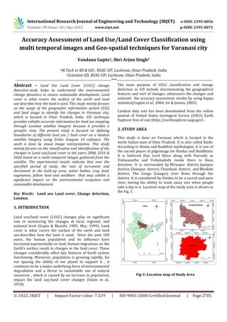
  • 1. International Research Journal of Engineering and Technology (IRJET) e-ISSN: 2395-0056 Volume: 09 Issue: 04 | Apr 2022 www.irjet.net p-ISSN: 2395-0072 © 2022, IRJET | Impact Factor value: 7.529 | ISO 9001:2008 Certified Journal | Page 2705 Accuracy Assessment of Land Use/Land Cover Classification using multi temporal images and Geo-spatial techniques for Varanasi city Vandana Gupta1, Shri Arjun Singh2 1M.Tech in RS & GIS , RSAC-UP, Lucknow, Uttar Pradesh, India 2Scientist-SD, RSAC-UP, Lucknow, Uttar Pradesh, India ---------------------------------------------------------------------***--------------------------------------------------------------------- Abstract – Land Use Land Cover (LULC) change detection study helps to understand the environmental change dynamics to ensure sustainable development. Land cover is what covers the surface of the earth and land use describes how the land is used. This study mainly focuses on the usage of the geographic information system (GIS) and land usage to identify the changes in Varanasi city, which is located in Uttar Pradesh, India. GIS technique provides reliable accurate information for land use mapping through Landsat satellite imagery because it provides a synoptic view. The present study is focused on defining boundaries of different land use / land cover on a landsat satellite Imagery using Erdas Imagine 14 software. The work is done by visual image interpretation. This study mainly focuses on the classification and identification of the changes in Land use/Land cover in the years 2000, 2010 & 2020 based on a multi temporal images gathered from the satellite. The experimental results indicate that over the specified period of study, the rate of increment and decrement in the built-up area, water bodies, crop land, vegetation, fallow land and sandbars that may exhibit a significant impact on the environmental ecosystem and sustainable development. Key Words: Land use Land cover, Change detection, Landsat. 1. INTRODUCTION Land use/land cover (LULC) changes play an significant role in monitoring the changes at local, regional, and national level (Gupta & Munshi, 1985; Mas, 1999). Land cover is what covers the surface of the earth and land use describes how the land is used. Since the past 100 years, the human population and its influence have increased exponentially on land. Human migrations on the Earth’s surface result in changes in the land cover. These changes considerably affect key features of Earth system functioning. Moreover, population is growing rapidly, far out spacing the ability of our planet to support it , it continues to be a major underlying force of environmental degradation and a threat to sustainable use of natural resources , which is caused by an increase in population, impact the land use/land cover changes (Islam et al., 2018). The main purpose of LULC classification and change detection in GIS include discriminating the geographical features and sort of changes, admeasure the changes and estimate the accuracy assessment results by using kappa statistics(Coppin et al., 2004; Im & Jensen, 2005). Landsat data sets has been downloaded from the online poartal of United States Geological Survey (USGS) Earth Explorer free of cost (http://earthexplorer.usgs.gov) . 2. STUDY AREA This study is done on Varanasi which is located in the north Indian state of Uttar Pradesh. It is also called Kashi. According to Hindu and Buddhist mythologies, it is one of the sacred places of pilgrimage for Hindus and Buddhists. It is believed that Lord Shiva along with Parvathi as Vishwanatha and Vishalaakshi reside there to bless devotees. It is surrounded by Mirzapur district, Jaunpur district, Ghazipur district, Chandauli district, and Bhadohi district. The Ganga (Ganges) river flows through the district. It is considered by Hindus to be a sacred and pure river, having the ability to wash away sins when people take a dip in it. Location map of the study area is shown in the Fig. 1. Fig-1: Location map of Study Area
  • 2. International Research Journal of Engineering and Technology (IRJET) e-ISSN: 2395-0056 Volume: 09 Issue: 04 | Apr 2022 www.irjet.net p-ISSN: 2395-0072 © 2022, IRJET | Impact Factor value: 7.529 | ISO 9001:2008 Certified Journal | Page 2706 3. DATA USED AND METHODOLOGY: Landsat satellite imageries datasets have been used in the study. In this study, LULC were prepared from Landsat data at decadal interval in ERDAS IMAGINE 14. Landsat-7 ETM+ (2000), Landsat-5 TM (2010) and Landsat-OLI (2020) were downloaded from the U.S. Geological Survey (www.usgs.gov.in). Then, all bands of datasets were stacked as a single image for each scene. Thereafter, imageries were projected in UTM projection system (datum WGS 1984, 44 N zone). Before the supervised classification, the dataset were masked for the study area. Details of Landsat images used in the study are given in the Table 1. Table1:- Details of Landsat images used in the study. Accuracy assessment is used to assess the quality of the information of LU/LC maps generated from the google earth pro data. The confusion matrices has been plotted as cross‐tabulations of information obtained from classified maps versus the google earth pro data. Hence, overall accuracy, user’s and producer’s accuracies and the kappa statistic were estimated from the confusion matrices(Liu & Mason, 2009). The overall accuracy is estimated by taking the ratio between sum of the major diagonal elements and the total number of pixels (N). The following equation used for determination of user’s accuracy, producer’s accuracy and kappa coefficient (k): User’s accuracy = Cii/Nri Producer’s accuracy = Cii/Ncj where,Nri is sum of any row i and Ncj is sum of any column j in the confusion matrix. 2.3. Methodology adopted for this analysis Flowchart for the Land use/ land cover changes and change detection methodology have been shown in figure 2. Fig-2:Flowchart of the methodology. 4. RESULTS AND DISCUSSIONS: The whole study area has been classified into six classes. Land use land cover (LULC) maps prepared at decadal interval and there has been a positive and negative variation in each category at each decadal interval. The area falling under each category for different five years (2000, 2010, 2020) has been given in table 1. There has been gradual decrease in area of water bodies in each decadal year. The fallow land area has increased 3.27 % in the year 2010, and again increased 2.4 % in the year 2020. The crop land area has increased by 3.58% in 2010 and then decreased by 14.22% in 2020. There is not very S.NO. Satellite data DATE PATH/ROW 1. Landsat-8 02/04/2020 142/42 142/43 2. Landsat-5 25/05/2010 142/42 142/43 3. Landsat-7 03/04/2000 142/42 142/43 Train the data by using visual interpretation method. Supervised classification by using maximum likelihood algorithm Generate the confusion matrix & Accuracy assessment analysis Results and discussion Generate the attribute table LULC map of the year 2000, 2010 and 2020 Satellite Data Image pre-processing
  • 3. International Research Journal of Engineering and Technology (IRJET) e-ISSN: 2395-0056 Volume: 09 Issue: 04 | Apr 2022 www.irjet.net p-ISSN: 2395-0072 © 2022, IRJET | Impact Factor value: 7.529 | ISO 9001:2008 Certified Journal | Page 2707 remarkable change in the area of sand bars. The area of vegetation has reduced by 8.05% in 2010 and increased by 4.66% in 2020. In 2000, the built up area was 3.62 % while it is 11.66 % of total area in 2020. It means that the built up land has increased in due respect of time. The maximum changes have been seen in the data depicting settlements and roads. The changes in settlements are found mainly in the area around Varanasi city and its surroundings. The LULC classes of Varanasi district during different time periods are shown in the Fig. 3 (a-c). The area distribution and changes in LULC classes are given Table 2 and 3 . Table 2: LandUse /Land Cover Area distribution. LULC classes AREA(%) 2000 AREA(%) 2010 AREA(%) 2020 WATER BODIES 1.35 1.11 1.76 SANDBARS 1.17 1.13 1.03 FALLOW LAND 7.66 10.93 13.38 BUILT UP AREA 3.62 5.1 11.66 VEGETATION 12.98 4.93 9.59 CROP LAND 73.22 76.8 62.58 TOTAL 100 100 100 Table 3: Changes in LULC during 2000–2010 and 2010-2020 CHAGES IN AREA(%) Period/LULC Classes 2000-2010 2010-2020 WATER BODIES -0.24 0.65 SANDBARS -0.04 -0.1 FALLOW LAND 3.27 2.45 BUILT UP AREA 1.48 6.56 VEGETATION -8.05 4.66 CROP LAND 3.58 -14.22 Note: Positive (+) value indicate gain in the area whereas negative (-) value indicate loss in area . Fig-3:LULC classes of Varanasi in (a)2000, (b)2010 & (c)2020 The google earth pro data is used as the reference for assessing the accuracy of classification. The accuracy and KAPPA statistics of the classified image checked with the help of accuracy assessment by confusion matrix preparation. The overall accuracy of the image is given in the Table 4. Table 4: Overall accuracy of classified images of different years YEAR Overall Accuracy KAPPA Statistics 2000 93.94% 92.66% 2010 91.66% 89.89% 2020 89.47% 86.44% 5. CONCLUSIONS In this study , GIS is used for understanding the LULC changes in Varanasi city over 20 years from 2000 to 2020. The technique used in this study is simple and inexpensive. The extent of land-use changes was determined using multitemporal Landsat satellite imagery. In this study, accuracy assessment analysis is done by using the confusion matrix. Significant changes in the LULC were observed in the study area between 2000 and 2020. During these 20 years, It is apparent that urban expansion is maximum than all the other land classifications. In short,
  • 4. International Research Journal of Engineering and Technology (IRJET) e-ISSN: 2395-0056 Volume: 09 Issue: 04 | Apr 2022 www.irjet.net p-ISSN: 2395-0072 © 2022, IRJET | Impact Factor value: 7.529 | ISO 9001:2008 Certified Journal | Page 2708 the results have shown that there is a significant increase in urban expansion leading to a significant drop in crop land use and vegetation during the study period. REFERENCES [1] Gupta, D. M., & Munshi, M. K. (1985). Urban change detection and land-use mapping of Delhi. International Journal of Remote Sensing, 6(3–4), 529–534. https://doi.org/10.1080/01431168508948474 [2] Islam, K., Jashimuddin, M., Nath, B., & Nath, T. K. (2018). Land use classification and change detection by using multi-temporal remotely sensed imagery: The case of Chunati wildlife sanctuary, Bangladesh. The Egyptian Journal of Remote Sensing and Space Sciences, 21(1), 37–47. https://doi.org/10.1016/j.ejrs.2016.12.005 [3] Coppin, P., Jonckheere, I., Nackaerts, K., Muys, B. &Lambin, E. (2004). Review article digital change detection methods in ecosystem monitoring: a review. International Journal of Remote Sensing 25:1565–1596. [4] Liu J.G. & Mason, P.J, (2009). Essential Image Processing and GIS for Remote Sensing. John Wiley & Sons, Inc.