Archaeological Survey Techniques
•Download as PPTX, PDF•
2 likes•3,094 views

Yr 11 HSC Ancient History

Recommended
More Related Content
What's hot
What's hot (20)
Viewers also liked
Viewers also liked (13)
Similar to Archaeological Survey Techniques
Similar to Archaeological Survey Techniques (20)
More from Alex Thompson
More from Alex Thompson (20)
Recently uploaded
Recently uploaded (20)
Archaeological Survey Techniques
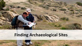
- 6. Finding Hidden Sites • Observing the surroundings • Mounds/ surface features • Fieldwalking • Surface artefacts • Trial trenches • Through Human Activity • Ploughing • Development • Construction of Roads • Fishing and underwater diving • Wars • Literature
- 7. Quick Quiz • How were these archaeological sites found?
- 16. Remote Sensing – Technological Tools • Aerial Survey • Satellite Photography • Geophysical Surveying Techniques
- 17. Aerial Photography • Since WW1 • Useful tool for archaeologists • Affordable – drones the way to go!
- 19. Crops marks – Roman Britain • https://www.futurelearn.com/courses/hadrians-wall/0/steps/5089 • (2.19mins) • Crop marks reveal twin towers defending Roman fort at Newstead
- 20. Soil Marks
- 22. Satellite Imagery • Available through NASA, government and commercial satellites • Covers large areas efficiently • Can be enhanced by filters (e.g.infrared) for greater contrast • Dr Sarah Parcak has found at least 35 new pyramids using satellite imagery
- 28. Geophysical Survey Techniques • Ground Penetrating Radar • Resistivity Surveying • Magnetic Surveying
- 30. Burial site identified by GPR
- 31. Resistivity Survey • Measures electric current between the probes
- 32. Resistivity Survey - Display of Results
- 33. Magnetic Surveying • Greater speed than resistivity surveying • Magnetic field is created underground
- 35. All these techniques help the archaeologist decide where to dig
- 36. Excavation of the Site • Why do archaeologists need a method of excavating a site?
- 37. Excavation of the Site • Why do archaeologists need a method of excavating a site? • Systematic examination of the site • Systematic recording of finds and their location
- 38. Excavation Methods • Grid Method – vertical view • Open Area Method – horizontal view
- 39. Grid Method • Square pattern of grids • Used for reference points for recording finds and buildings • Wall between grids is called a baulk • Baulks contain the vertical picture of the site • Baulks can be removed later
- 45. Open Area Method • Method introduced in 1940s • Large area stripped of top soil • Horizontal layers examined • Relationship between layers
- 47. • Composite of both methods • Auger to take core samples
- 48. Tools used in Excavations
- 49. Underwater Archaeology • Some techniques same as land archaeology • Some techniques from diving
- 54. Further investigation • Activity – Hypothetical dig – page 13 • Discuss together • For discussion – page 13 • Consider the questions • Underwater Archaeology – page 14 • Investigate methods and issues further • Archaeological Team – page 9 • Look up any team experts you are not sure about • Discovery of other famous sites – page 5 • Investigate sites with which you are unfamiliar to find out how they were discovered
Editor's Notes
- Some archaeological sites are obvious - pyramids
- Some not – Tuthankhamun’s tomb. Tourists at entrance in 1923 while excavation was still going on
- Even when overgrown and covered in soil, by observation you can tell that something is here at Hadrian’s Wall (section near Milecastle)
- Part of Hoxne Hoarde – hidden
- Pottery bits discovered in 1974 by peasants digging a water well 1.6km to the east of this mound (which turned out to be burial mound of First Emperor)
- Discovered by two brothers, Viggo and Emil Højgaard, and Viggo's wife, Grethe Højgaard. cutting peat in Denmark in 1950
- Non-destructive methods for finding what is below the surface
- After ploughing, discolouration of the soil indicated buried site below soil surface.
- Cornwall - Earthworks of prehistoric field boundaries are clearly visible as shadow marks underlying the modern field system which was laid out in the eighteenth or nineteenth century.
- Satellite image of modern city of San El Hagar and ancient city of Tanis, Egyptian Delta
- Close up of Tanis site from space
- Infrared enhancement of Tanis
- Saqara unflitered Nasa image
- Filtered NASA imagery of Saqqara
- Radar waves hit the buried object and bounce back to be recorded
- Mortimer Wheeler using grid method. He was first archaeologist to use this method (1930 -35). What can you see here in this picture?
- Excavation in northwestern part of Tell Sabi Abyad (30 km inside Syria, near Turkish border), with settlement remains dating between 6800 and 6200 BC.
- Make sure students do the Activity: Hypothetical dig of a tell on page 13 at end of this lesson or for homework and discuss together to give them the idea of what to look for
- Kathleen Kenyon used grid method during excavation of Jericho in 1952-58. By comparing finds with strategraphy layers in the baulk, she was able to determine the exact provenance of a found object or feature to adjacent layers of earth ("strata"). During Kenyon's excavations at Jericho, this technique helped discern the long and complicated occupational history of the site. It was believed that this approach allowed more precise stratigraphic observations than earlier "horizontal exposure" techniques which relied on architectural and ceramic analysis.
- Open area excavation in Perthshire, Scotland
- Open area excavation of Roman town Venta Icenorum founded in about 60AD at Caistor St Edmund, East Anglia. What can you see here?
- Trenches in open area excavation
- What do you see here – hose to remove sand, grid, diver recording artefacts on plan
- Corrosion of artefact – cannon? Whether to raise or leave in situ
- Examining heavily corroded artefact from underwater site in the lab
- Treating artefacts in the lab