SlideShare a Scribd company logo
1 of 1
Download to read offline
Risks of cryogenic landslide hazards and their impact on ecosystems in cold environments
Polina Lemenkova
Presented at: IRLA2014 International Symposium. The Effects of Irrigation and Drainage on Rural and Urban Landscapes.
26-28 November 2014 | Patras, Greece
Abstract
Research focuses on monitoring landscapes downgrading in specific conditions
of Arctic ecosystems with cold climate conditions (marshes, permafrost, high
humidity and moisture). Specific case study: cryogenic landslides typical for
cold environments with permafrost. Area: Yamal Peninsula. Aim: analysis of
the environmental changes caused by cryogenic landslides in northern land-
scapes affecting sensitive Arctic ecosystems. Thaw of the permafrost layer
causes destruction of the ground soil layer and activates cryogenic landslide
processes. After disaster, vegetation coverage needs a long time to recover, due
to the sensitivity of the specific northern environment, and land cover types
change. ILWIS GIS was used to process 2 satellite images Landsat TM taken
at 1988 and 2011, to assess spatiotemporal changes in the land cover types.
Research shown ILWIS GIS based spatial analysis for environmental mapping.
Research Area
Research area: Bovanenkovo region, Yamal Peninsula. Geomorphol-
ogy: flat homogeneous lowland region with low-lying plains of heights
<90m. Such geographic settings create specific local environmen-
tal conditions. Yamal has the largest high-latitude wetland system
in the World: 900,000 km2 of peatlands, wetlands, dense lakes and
river network. Seasonal flooding, active erosion, permafrost and lo-
cal landslides. Dominating tundra vegetation types: heath, grasses,
moss, lichens, woody plants (shrubs and willows). Environmental
problems: climate change and landslides, affecting landscapes and
causing changes in land cover types.
Research Problem
Environmental problem of Yamal: cryogenic landslides. Processes of superficial
cryogenic landslides are active in tundra. Permafrost serves as a shear surface
for sliding, contributes to the landslide formation. Cryogenic landslides develop
on fine-grained, saline marine sediments: common destructive disastrous geo-
morphological hazards on the Yamal Peninsula covering ca 70% of the area.
Land Cover Types
The defined classes include following landscapes types: shrub tundra, willows,
tall willows, short shrub tundra, sparse short shrub tundra, dry grass heath,
sedge grass tundra, dry short shrub tundra, dry short shrub sedge tundra,
wet peatland, peatland (sphagnum). The pixels were associated with land cover
classes using their digital numbers, similar to key samples.
Landslides
Development of permafrost => scarce
vegetation. Several years after land-
slides, vegetation changes gradually:
grass, moss, lichen, shrub => sedge
=> willows. Landslide-affected areas
of bare slopes: willow shrubs => in-
dicator for former landslides. Vegeta-
tion stages show landslides age: early-
stage (primitive mosses or lichen) =>
recent landslide formation; meadow
and willow shrubs with high canopy
=> final stage of landslides. Ground
waters salinity and chemical content of
sediments indicates age of landslides.
Mapping
GIS method consists in Landsat TM image classification, spatial analysis and thematic mapping, technically performed in ILIWIS GIS. Landsat
scenes for land cover mapping: advantages of application in geosciences and cartography, ca 40 year history of the image record, and free
availability. Landsat scenes are series of satellite imagery by NASA and the USGS with 30-m resolution.
Workflow
Workflow includes following steps:
1. Data: orthorectified Landsat TM files in GeoTIFF acquired over the area
of Bovanenkovo, Yamal Peninsula. Images: 1988 and 2011, taken in
growing season with visible vegetation. Data capture, import, converting
.img file into ASCII raster format (GDAL). After converting, each image
contained collection of 7 Landsat raster bands.
2. Data pre-processing: Enhancement of visual color and contrast. Geo-
graphic referencing of Landsat TM: setting UTM projection, E Zone 42,
N Zone W, WGS 1984 datum (Georeference Corner Editor).
3. Area Of Interest (AOI) was identified and cropped on raw images This
area shows region in a large scale which represents tundra landscapes.
4. Supervised Classification by Minimal Distance method. Method is based
on spatial analysis of the spectral signatures of object variables.
5. Sampling of classes: using Sample Set tool in ILWIS GIS. Training pixels
for each land cover type with distinguishable contrast colors selected as
representative samples and stored as classification key.
Results
Willows covers 2750,57 ha in 2011,
which is more than in 1988, when
it covered 1547,52 ha (both ’tall wil-
lows’ and ’willows’ classes). Increase
in tundra vegetation: ’short shrub tun-
dra’, ’sparse short shrub tundra’ and
’dry short shrub tundra’ have more ar-
eas in 2011 comparing to 1988: ca
5442,00 ha vs 1823,00 ha. Increase
of wooden vegetation class goes along
with shrunk of grass and heath areas:
’dry grass heath’ had area of 3335.39
ha in 1988, now covers 1204.94 ha.
Slight decrease can be noticed in the
’peatlands’ and ’wet peatlands’ classes
3958.40 ha against 2765.41 ha in
2011 by ’wet peatlands’, and 625.71
ha in 1988 vs 488.69 ha by ’peatland
(sphagnum)’ class.
Geographic Settings
Cryogenic landslides have origin in
thawing of underground permafrost
layer, which has negative effects de-
structing upper soil layer and vegeta-
tion coverage. Area of the Kara Sea
is shallow: almost 40% of the conti-
nental shelf is <50 m. The sea coasts
are mostly flat, flooded during the high
tide. Located in the area of permafrost
distribution, soils are frozen for the
most of the year, with the depth of the
frozen soil up to 0.2 m in the north and
2 m in the south. The ecosystems of
the region are adapted towards specific
Arctic environment.
Conclusions
Results show overall increase of woody
vegetation (willows and shrubs), not
typical for local environment, and de-
crease of peatlands, grass and heath.
Environmental factors: active cryo-
genic landsliding. Climatic factor: in-
crease of annual average T => per-
mafrost thawing and abnormal in-
crease of woody plants. Gradual
changes in plant species patterns
and distribution affect landscapes in
Yamal. Triggering factors: com-
plex climatic-environmental changes
in Arctic and local cryogenic processes,
e.g. successive change in vegetation
recovering after cryogenic landslides.
Acknowledgements
Current work has been supported by the Finnish Center for International
Mobility (CIMO) for author’s research stay at the University of Lapland, Arctic
Center (Grant No. TM-10-7124), during 01 July - 31 December 2011.
Bibliography
Author’s publications on Geography, Remote Sensing and GIS:
1
S. Gauger, G. Kuhn, K. Gohl, T. Feigl, P. Lemenkova, and C. Hillenbrand,
“Swath-bathymetric mapping”, The expedition ANTARKTIS-XXIII/4 of the Re-
search Vessel ’Polarstern’ in 2006. Reports on Polar and Marine Research
557, 38–45 (2007).
2
K. Gohl et al., Crustal and Sedimentary Structures and Geodynamic Evolution
of the West Antarctic Continental Margin and Pine Island Bay (Bremerhaven,
Germany, 2006).
3
M. Klauˇco, B. Gregorová, U. Stankov, V. Markovi´c, and P. Lemenkova, “Land-
scape metrics as indicator for ecological significance: assessment of Sitno
Natura 2000 sites, Slovakia”, in Ecology and environmental protection, Pro-
ceedings of International Conference (2014), pp. 85–90.
4
M. Klauˇco, B. Gregorová, U. Stankov, V. Markovi´c, and P. Lemenkova, “De-
termination of ecological significance based on geostatistical assessment: a
case study from the Slovak Natura 2000 protected area”, Central European
Journal of Geosciences 5, 28–42 (2013).
5
G. Kuhn et al., The response of quaternary climatic cycles in the South-East Pa-
cific: development of the opal belt and dynamics behavior of the West Antarctic
ice sheet (Bremerhaven, Germany, 2006).
6
P. Lemenkova, “Cost-Effective Raster Image Processing for Geoecological Anal-
ysis using ISOCLUST Classifier: a Case Study of Estonian Landscapes”, in
Modern problems of geoecology and landscapes studies (2014), pp. 74–76.
7
P. Lemenkova, “Rural Sustainability and Management of Natural Resources
in Tian Shan Region, Central Asia”, in Celebrating pastoral life. heritage and
economic development (2014), pp. 81–89.
8
P. Lemenkova, “Opportunities for Classes of Geography in the High School:
the Use of ’CORINE’ Project Data, Satellite Images and IDRISI GIS for Geovi-
sualization”, in Perspectives for the Development of Higher Education (2014),
pp. 284–286.
9
P. Lemenkova, “Monitoring changes in agricultural landscapes of Central Eu-
rope, Hungary: application of ILWIS GIS for image processing”, in Geoinfor-
matics: theoretical and applied aspects (2013).
10
P. Lemenkova, “Geospatial Technology for Land Cover Analysis”, MEA Geospa-
tial Digest (2013).
11
P. Lemenkova, “Impacts of Climate Change on Landscapes in Central Europe,
Hungary”, in Current Problems of Ecology, Ecological monitoring and man-
agement of natural protection, Vol. 2 (2012), pp. 134–136.
12
P. Lemenkova, “Water Supply and Usage in Central Asia, Tian Shan Basin”,
in 4th International Symposium for Doctoral studies in the Fields of Civil
Engineering, Architecture & Environmental Protection (PhiDAC-2012) (Sept.
2012), pp. 331–338.
13
P. Lemenkova, “Seagrass Mapping and Monitoring Along the Coasts of Crete,
Greece”, M.Sc. Thesis (University of Twente, Faculty of Earth Observation and
Geoinformation (ITC), Enschede, Netherlands, Mar. 8, 2011), 158 pp.
14
P. Lemenkova, “Using ArcGIS in Teaching Geosciences”, Russian, B.Sc. Thesis
(Lomonosov Moscow State University, Moscow, Russia, June 5, 2007), 58 pp.
15
P. Lemenkova, “Geoecological Mapping of the Barents and Pechora Seas”, Rus-
sian, B.Sc. Thesis (Moscow, Russia, 2004), 78 pp.
16
P. Lemenkova, Ecological and Geographical Mapping of the Baltic Sea Region
in the Gulf of Finland, Russian, Moscow, Russia: Lomonosov Moscow State
University, Mar. 30, 2002, Term Paper.
17
P. Lemenkova and I. Elek, “Clustering Algorithm in ILWIS GIS for Classifica-
tion of Landsat TM Scenes: a Case Study of Mecsek Hills Region, Hungary”,
in Geosciences and environment, Near-surface geophysics, Proceedings 3rd
International Conference (2012).
18
P. Lemenkova, B. Forbes, and T. Kumpula, “Mapping Land Cover Changes
Using Landsat TM: A Case Study of Yamal Ecosystems, Arctic Russia”, in
Geoinformatics: theoretical and applied aspects (2012).
19
H. W. Schenke and P. Lemenkova, “Zur Frage der Meeresboden-
Kartographie: Die Nutzung von AutoTrace Digitizer für die Vektorisierung
der Bathymetrischen Daten in der Petschora-See”, German, Hydrographische
Nachrichten 25, 16–21 (2008).
20
I. Suetova, L. Ushakova, and P. Lemenkova, “Geoecological Mapping of the
Barents Sea Using GIS”, in International Cartographic Conference (ICC)
(2005).
21
I. Suetova, L. Ushakova, and P. Lemenkova, “Geoinformation mapping of the
Barents and Pechora Seas”, Geography and Natural Resources 4, 138–142
(2005).

More Related Content

What's hot

Erodibility of slash and-burn soils along a toposequence in relation to four ...
Erodibility of slash and-burn soils along a toposequence in relation to four ...Erodibility of slash and-burn soils along a toposequence in relation to four ...
Erodibility of slash and-burn soils along a toposequence in relation to four ...Alexander Decker
 
Climate Increases Regional Tree Growth Variability In Iberian Pine Forests
Climate Increases Regional Tree Growth Variability In Iberian Pine ForestsClimate Increases Regional Tree Growth Variability In Iberian Pine Forests
Climate Increases Regional Tree Growth Variability In Iberian Pine ForestsHibrids
 
Land use cover dynamics in ribb watershed, north western ethiopia
Land use cover dynamics in ribb watershed, north western ethiopiaLand use cover dynamics in ribb watershed, north western ethiopia
Land use cover dynamics in ribb watershed, north western ethiopiaAlexander Decker
 
Applying advanced spatial tools for landscape analysis and climate change ada...
Applying advanced spatial tools for landscape analysis and climate change ada...Applying advanced spatial tools for landscape analysis and climate change ada...
Applying advanced spatial tools for landscape analysis and climate change ada...World Agroforestry (ICRAF)
 
Hao 2011 STR Personal copy
Hao 2011 STR Personal copyHao 2011 STR Personal copy
Hao 2011 STR Personal copyHongtao HAO
 
Shrinkage and carbon stock in wetlands of fogera plain, north west ethiopia
Shrinkage and carbon stock in wetlands of fogera plain, north west ethiopiaShrinkage and carbon stock in wetlands of fogera plain, north west ethiopia
Shrinkage and carbon stock in wetlands of fogera plain, north west ethiopiaAlexander Decker
 
JesseMiller_MalcolmNichols_FireAndLULCResearchPaper.docx
JesseMiller_MalcolmNichols_FireAndLULCResearchPaper.docxJesseMiller_MalcolmNichols_FireAndLULCResearchPaper.docx
JesseMiller_MalcolmNichols_FireAndLULCResearchPaper.docxMalcolm Nichols
 
PhD Thesis by Iago Otero 25 March 2010
PhD Thesis by Iago Otero 25 March 2010PhD Thesis by Iago Otero 25 March 2010
PhD Thesis by Iago Otero 25 March 2010iagootero
 
David Lindenmayer_LTERN and the conservation and management of temperate euca...
David Lindenmayer_LTERN and the conservation and management of temperate euca...David Lindenmayer_LTERN and the conservation and management of temperate euca...
David Lindenmayer_LTERN and the conservation and management of temperate euca...TERN Australia
 
Environmental Changes and Effects on a Population of Smooth Newt Lissotriton ...
Environmental Changes and Effects on a Population of Smooth Newt Lissotriton ...Environmental Changes and Effects on a Population of Smooth Newt Lissotriton ...
Environmental Changes and Effects on a Population of Smooth Newt Lissotriton ...IJEAB
 
Systematic framework to assess restoration actions and outcomes based on meas...
Systematic framework to assess restoration actions and outcomes based on meas...Systematic framework to assess restoration actions and outcomes based on meas...
Systematic framework to assess restoration actions and outcomes based on meas...Richard Thackway
 
Tree regeneration, Fenner School July 2009
Tree regeneration, Fenner School July 2009Tree regeneration, Fenner School July 2009
Tree regeneration, Fenner School July 2009joernfischer
 
Report of guanica and yunque
Report of guanica and yunqueReport of guanica and yunque
Report of guanica and yunqueGustavo Perez
 
Monitoring Global Biome Dynamics from Space
Monitoring Global Biome Dynamics from Space Monitoring Global Biome Dynamics from Space
Monitoring Global Biome Dynamics from Space Cassidy Rankine
 

What's hot (19)

Erodibility of slash and-burn soils along a toposequence in relation to four ...
Erodibility of slash and-burn soils along a toposequence in relation to four ...Erodibility of slash and-burn soils along a toposequence in relation to four ...
Erodibility of slash and-burn soils along a toposequence in relation to four ...
 
Climate Increases Regional Tree Growth Variability In Iberian Pine Forests
Climate Increases Regional Tree Growth Variability In Iberian Pine ForestsClimate Increases Regional Tree Growth Variability In Iberian Pine Forests
Climate Increases Regional Tree Growth Variability In Iberian Pine Forests
 
Land use cover dynamics in ribb watershed, north western ethiopia
Land use cover dynamics in ribb watershed, north western ethiopiaLand use cover dynamics in ribb watershed, north western ethiopia
Land use cover dynamics in ribb watershed, north western ethiopia
 
Applying advanced spatial tools for landscape analysis and climate change ada...
Applying advanced spatial tools for landscape analysis and climate change ada...Applying advanced spatial tools for landscape analysis and climate change ada...
Applying advanced spatial tools for landscape analysis and climate change ada...
 
Soil moisture
Soil moistureSoil moisture
Soil moisture
 
Valgma landscape
Valgma landscapeValgma landscape
Valgma landscape
 
GEB.PDF
GEB.PDFGEB.PDF
GEB.PDF
 
Hao 2011 STR Personal copy
Hao 2011 STR Personal copyHao 2011 STR Personal copy
Hao 2011 STR Personal copy
 
July 29-330-Greg Schmidt
July 29-330-Greg SchmidtJuly 29-330-Greg Schmidt
July 29-330-Greg Schmidt
 
Shrinkage and carbon stock in wetlands of fogera plain, north west ethiopia
Shrinkage and carbon stock in wetlands of fogera plain, north west ethiopiaShrinkage and carbon stock in wetlands of fogera plain, north west ethiopia
Shrinkage and carbon stock in wetlands of fogera plain, north west ethiopia
 
Scert final
Scert finalScert final
Scert final
 
JesseMiller_MalcolmNichols_FireAndLULCResearchPaper.docx
JesseMiller_MalcolmNichols_FireAndLULCResearchPaper.docxJesseMiller_MalcolmNichols_FireAndLULCResearchPaper.docx
JesseMiller_MalcolmNichols_FireAndLULCResearchPaper.docx
 
PhD Thesis by Iago Otero 25 March 2010
PhD Thesis by Iago Otero 25 March 2010PhD Thesis by Iago Otero 25 March 2010
PhD Thesis by Iago Otero 25 March 2010
 
David Lindenmayer_LTERN and the conservation and management of temperate euca...
David Lindenmayer_LTERN and the conservation and management of temperate euca...David Lindenmayer_LTERN and the conservation and management of temperate euca...
David Lindenmayer_LTERN and the conservation and management of temperate euca...
 
Environmental Changes and Effects on a Population of Smooth Newt Lissotriton ...
Environmental Changes and Effects on a Population of Smooth Newt Lissotriton ...Environmental Changes and Effects on a Population of Smooth Newt Lissotriton ...
Environmental Changes and Effects on a Population of Smooth Newt Lissotriton ...
 
Systematic framework to assess restoration actions and outcomes based on meas...
Systematic framework to assess restoration actions and outcomes based on meas...Systematic framework to assess restoration actions and outcomes based on meas...
Systematic framework to assess restoration actions and outcomes based on meas...
 
Tree regeneration, Fenner School July 2009
Tree regeneration, Fenner School July 2009Tree regeneration, Fenner School July 2009
Tree regeneration, Fenner School July 2009
 
Report of guanica and yunque
Report of guanica and yunqueReport of guanica and yunque
Report of guanica and yunque
 
Monitoring Global Biome Dynamics from Space
Monitoring Global Biome Dynamics from Space Monitoring Global Biome Dynamics from Space
Monitoring Global Biome Dynamics from Space
 

Similar to Risks of Cryogenic Landslide Hazards and Their Impact on Ecosystems in Cold Environments

Lesson6 greeningarctic20110315(2)
Lesson6 greeningarctic20110315(2)Lesson6 greeningarctic20110315(2)
Lesson6 greeningarctic20110315(2)Edie Barbour
 
Mapping Land Cover Changes Using Landsat TM: a Case Study of Yamal Ecosystems...
Mapping Land Cover Changes Using Landsat TM: a Case Study of Yamal Ecosystems...Mapping Land Cover Changes Using Landsat TM: a Case Study of Yamal Ecosystems...
Mapping Land Cover Changes Using Landsat TM: a Case Study of Yamal Ecosystems...Universität Salzburg
 
The North America and Eurasia Arctic transects:
The North America and Eurasia Arctic transects: The North America and Eurasia Arctic transects:
The North America and Eurasia Arctic transects: Edie Barbour
 
Evs2011 talk two_transects20110404(3)
Evs2011 talk two_transects20110404(3)Evs2011 talk two_transects20110404(3)
Evs2011 talk two_transects20110404(3)Edie Barbour
 
Geoinformation monitoring of regenerative successions at the territory of Kho...
Geoinformation monitoring of regenerative successions at the territory of Kho...Geoinformation monitoring of regenerative successions at the territory of Kho...
Geoinformation monitoring of regenerative successions at the territory of Kho...Liashenko Dmytro
 
Bot deptlecture20110310(1)
Bot deptlecture20110310(1)Bot deptlecture20110310(1)
Bot deptlecture20110310(1)Edie Barbour
 
Intro Yamaltalk(1)
Intro Yamaltalk(1)Intro Yamaltalk(1)
Intro Yamaltalk(1)Edie Barbour
 
Geohydrological study of weathered basement aquifers in Oban Massif and envir...
Geohydrological study of weathered basement aquifers in Oban Massif and envir...Geohydrological study of weathered basement aquifers in Oban Massif and envir...
Geohydrological study of weathered basement aquifers in Oban Massif and envir...iosrjce
 
E042028035
E042028035E042028035
E042028035inventy
 
E042028035
E042028035E042028035
E042028035inventy
 
Iab2008 goa0811120(1)
Iab2008 goa0811120(1)Iab2008 goa0811120(1)
Iab2008 goa0811120(1)Edie Barbour
 
GEOtop Sisef presentation
GEOtop Sisef presentationGEOtop Sisef presentation
GEOtop Sisef presentationRiccardo Rigon
 
Land Use Land Cover Change Detection of Gulbarga City Using Remote Sensing an...
Land Use Land Cover Change Detection of Gulbarga City Using Remote Sensing an...Land Use Land Cover Change Detection of Gulbarga City Using Remote Sensing an...
Land Use Land Cover Change Detection of Gulbarga City Using Remote Sensing an...ijsrd.com
 
Hydrological responses to forest cover change in mountains under projected cl...
Hydrological responses to forest cover change in mountains under projected cl...Hydrological responses to forest cover change in mountains under projected cl...
Hydrological responses to forest cover change in mountains under projected cl...Agriculture Journal IJOEAR
 
Mediterranean landscapes characterization
Mediterranean landscapes characterizationMediterranean landscapes characterization
Mediterranean landscapes characterizationDavide Rizzo
 
Identification Of Soil Erosion Prone Zones Using Geomatics Technology In Part...
Identification Of Soil Erosion Prone Zones Using Geomatics Technology In Part...Identification Of Soil Erosion Prone Zones Using Geomatics Technology In Part...
Identification Of Soil Erosion Prone Zones Using Geomatics Technology In Part...IJERA Editor
 
MORPHOMETRIC ANALYSIS OF THE SUMANPA RIVER CATCHMENTAT MAMPONG-ASHANTI IN GHANA
MORPHOMETRIC ANALYSIS OF THE SUMANPA RIVER CATCHMENTAT MAMPONG-ASHANTI IN GHANAMORPHOMETRIC ANALYSIS OF THE SUMANPA RIVER CATCHMENTAT MAMPONG-ASHANTI IN GHANA
MORPHOMETRIC ANALYSIS OF THE SUMANPA RIVER CATCHMENTAT MAMPONG-ASHANTI IN GHANAEric Takyi Atakora , Ph.D (candidate)
 
Evaluation of Land Suitability for Stone Pine (Pinus pinea) plantation in Leb...
Evaluation of Land Suitability for Stone Pine (Pinus pinea) plantation in Leb...Evaluation of Land Suitability for Stone Pine (Pinus pinea) plantation in Leb...
Evaluation of Land Suitability for Stone Pine (Pinus pinea) plantation in Leb...IJEAB
 
Llano_del_cedro_main01
Llano_del_cedro_main01Llano_del_cedro_main01
Llano_del_cedro_main01Greg Burton
 

Similar to Risks of Cryogenic Landslide Hazards and Their Impact on Ecosystems in Cold Environments (20)

Lesson6 greeningarctic20110315(2)
Lesson6 greeningarctic20110315(2)Lesson6 greeningarctic20110315(2)
Lesson6 greeningarctic20110315(2)
 
Mapping Land Cover Changes Using Landsat TM: a Case Study of Yamal Ecosystems...
Mapping Land Cover Changes Using Landsat TM: a Case Study of Yamal Ecosystems...Mapping Land Cover Changes Using Landsat TM: a Case Study of Yamal Ecosystems...
Mapping Land Cover Changes Using Landsat TM: a Case Study of Yamal Ecosystems...
 
The North America and Eurasia Arctic transects:
The North America and Eurasia Arctic transects: The North America and Eurasia Arctic transects:
The North America and Eurasia Arctic transects:
 
Evs2011 talk two_transects20110404(3)
Evs2011 talk two_transects20110404(3)Evs2011 talk two_transects20110404(3)
Evs2011 talk two_transects20110404(3)
 
Geoinformation monitoring of regenerative successions at the territory of Kho...
Geoinformation monitoring of regenerative successions at the territory of Kho...Geoinformation monitoring of regenerative successions at the territory of Kho...
Geoinformation monitoring of regenerative successions at the territory of Kho...
 
Bot deptlecture20110310(1)
Bot deptlecture20110310(1)Bot deptlecture20110310(1)
Bot deptlecture20110310(1)
 
Intro Yamaltalk(1)
Intro Yamaltalk(1)Intro Yamaltalk(1)
Intro Yamaltalk(1)
 
Geohydrological study of weathered basement aquifers in Oban Massif and envir...
Geohydrological study of weathered basement aquifers in Oban Massif and envir...Geohydrological study of weathered basement aquifers in Oban Massif and envir...
Geohydrological study of weathered basement aquifers in Oban Massif and envir...
 
E042028035
E042028035E042028035
E042028035
 
E042028035
E042028035E042028035
E042028035
 
2 Tsolmon
2   Tsolmon2   Tsolmon
2 Tsolmon
 
Iab2008 goa0811120(1)
Iab2008 goa0811120(1)Iab2008 goa0811120(1)
Iab2008 goa0811120(1)
 
GEOtop Sisef presentation
GEOtop Sisef presentationGEOtop Sisef presentation
GEOtop Sisef presentation
 
Land Use Land Cover Change Detection of Gulbarga City Using Remote Sensing an...
Land Use Land Cover Change Detection of Gulbarga City Using Remote Sensing an...Land Use Land Cover Change Detection of Gulbarga City Using Remote Sensing an...
Land Use Land Cover Change Detection of Gulbarga City Using Remote Sensing an...
 
Hydrological responses to forest cover change in mountains under projected cl...
Hydrological responses to forest cover change in mountains under projected cl...Hydrological responses to forest cover change in mountains under projected cl...
Hydrological responses to forest cover change in mountains under projected cl...
 
Mediterranean landscapes characterization
Mediterranean landscapes characterizationMediterranean landscapes characterization
Mediterranean landscapes characterization
 
Identification Of Soil Erosion Prone Zones Using Geomatics Technology In Part...
Identification Of Soil Erosion Prone Zones Using Geomatics Technology In Part...Identification Of Soil Erosion Prone Zones Using Geomatics Technology In Part...
Identification Of Soil Erosion Prone Zones Using Geomatics Technology In Part...
 
MORPHOMETRIC ANALYSIS OF THE SUMANPA RIVER CATCHMENTAT MAMPONG-ASHANTI IN GHANA
MORPHOMETRIC ANALYSIS OF THE SUMANPA RIVER CATCHMENTAT MAMPONG-ASHANTI IN GHANAMORPHOMETRIC ANALYSIS OF THE SUMANPA RIVER CATCHMENTAT MAMPONG-ASHANTI IN GHANA
MORPHOMETRIC ANALYSIS OF THE SUMANPA RIVER CATCHMENTAT MAMPONG-ASHANTI IN GHANA
 
Evaluation of Land Suitability for Stone Pine (Pinus pinea) plantation in Leb...
Evaluation of Land Suitability for Stone Pine (Pinus pinea) plantation in Leb...Evaluation of Land Suitability for Stone Pine (Pinus pinea) plantation in Leb...
Evaluation of Land Suitability for Stone Pine (Pinus pinea) plantation in Leb...
 
Llano_del_cedro_main01
Llano_del_cedro_main01Llano_del_cedro_main01
Llano_del_cedro_main01
 

More from Universität Salzburg

Accurate and rapid big spatial data processing by scripting cartographic algo...
Accurate and rapid big spatial data processing by scripting cartographic algo...Accurate and rapid big spatial data processing by scripting cartographic algo...
Accurate and rapid big spatial data processing by scripting cartographic algo...Universität Salzburg
 
Bringing Geospatial Analysis to the Social Studies: an Assessment of the City...
Bringing Geospatial Analysis to the Social Studies: an Assessment of the City...Bringing Geospatial Analysis to the Social Studies: an Assessment of the City...
Bringing Geospatial Analysis to the Social Studies: an Assessment of the City...Universität Salzburg
 
Detection of Vegetation Coverage in Urban Agglomeration of Brussels by NDVI I...
Detection of Vegetation Coverage in Urban Agglomeration of Brussels by NDVI I...Detection of Vegetation Coverage in Urban Agglomeration of Brussels by NDVI I...
Detection of Vegetation Coverage in Urban Agglomeration of Brussels by NDVI I...Universität Salzburg
 
Investigation of the Lake Victoria Region (Africa: Tanzania, Kenya and Uganda)
Investigation of the Lake Victoria Region (Africa: Tanzania, Kenya and Uganda)Investigation of the Lake Victoria Region (Africa: Tanzania, Kenya and Uganda)
Investigation of the Lake Victoria Region (Africa: Tanzania, Kenya and Uganda)Universität Salzburg
 
Interpretation of Landscape Values, Typology and Quality Using Methods of Spa...
Interpretation of Landscape Values, Typology and Quality Using Methods of Spa...Interpretation of Landscape Values, Typology and Quality Using Methods of Spa...
Interpretation of Landscape Values, Typology and Quality Using Methods of Spa...Universität Salzburg
 
Economic assessment of landslide risk for the Waidhofen a.d. Ybbs region, Alp...
Economic assessment of landslide risk for the Waidhofen a.d. Ybbs region, Alp...Economic assessment of landslide risk for the Waidhofen a.d. Ybbs region, Alp...
Economic assessment of landslide risk for the Waidhofen a.d. Ybbs region, Alp...Universität Salzburg
 
Quality assessment of data from CHRIS/PROBA
Quality assessment of data from CHRIS/PROBAQuality assessment of data from CHRIS/PROBA
Quality assessment of data from CHRIS/PROBAUniversität Salzburg
 
Conservation Area Designation in the Andes
Conservation Area Designation in the AndesConservation Area Designation in the Andes
Conservation Area Designation in the AndesUniversität Salzburg
 
Seagrass mapping and monitoring along the coast of Crete, Greece
Seagrass mapping and monitoring along the coast of Crete, GreeceSeagrass mapping and monitoring along the coast of Crete, Greece
Seagrass mapping and monitoring along the coast of Crete, GreeceUniversität Salzburg
 
Why Should We Stand for Geothermal Energy ? Example of the Negative Impacts o...
Why Should We Stand for Geothermal Energy ? Example of the Negative Impacts o...Why Should We Stand for Geothermal Energy ? Example of the Negative Impacts o...
Why Should We Stand for Geothermal Energy ? Example of the Negative Impacts o...Universität Salzburg
 
Using ArcGIS in Teaching Geosciences
Using ArcGIS in Teaching GeosciencesUsing ArcGIS in Teaching Geosciences
Using ArcGIS in Teaching GeosciencesUniversität Salzburg
 
How could obligation chain be structured along cross-border gas supply for...
   How could obligation chain be structured along cross-border gas supply for...   How could obligation chain be structured along cross-border gas supply for...
How could obligation chain be structured along cross-border gas supply for...Universität Salzburg
 
Using K-means algorithm classifier for urban landscapes classification in Tai...
Using K-means algorithm classifier for urban landscapes classification in Tai...Using K-means algorithm classifier for urban landscapes classification in Tai...
Using K-means algorithm classifier for urban landscapes classification in Tai...Universität Salzburg
 
Rural Sustainability and Management of Natural Resources in Tian Shan Region,...
Rural Sustainability and Management of Natural Resources in Tian Shan Region,...Rural Sustainability and Management of Natural Resources in Tian Shan Region,...
Rural Sustainability and Management of Natural Resources in Tian Shan Region,...Universität Salzburg
 
Mapping Agricultural Lands by Means of GIS for Monitoring Use of Natural Reso...
Mapping Agricultural Lands by Means of GIS for Monitoring Use of Natural Reso...Mapping Agricultural Lands by Means of GIS for Monitoring Use of Natural Reso...
Mapping Agricultural Lands by Means of GIS for Monitoring Use of Natural Reso...Universität Salzburg
 
Seagrass Mapping and Monitoring Along the Coasts of Crete, Greece
Seagrass Mapping and Monitoring Along the Coasts of Crete, GreeceSeagrass Mapping and Monitoring Along the Coasts of Crete, Greece
Seagrass Mapping and Monitoring Along the Coasts of Crete, GreeceUniversität Salzburg
 
Data Sharing, Distribution and Updating Using Social Coding Community Github ...
Data Sharing, Distribution and Updating Using Social Coding Community Github ...Data Sharing, Distribution and Updating Using Social Coding Community Github ...
Data Sharing, Distribution and Updating Using Social Coding Community Github ...Universität Salzburg
 
Seagrass Mapping and Monitoring Along the Coasts of Crete, Greece. MSc Thesis...
Seagrass Mapping and Monitoring Along the Coasts of Crete, Greece. MSc Thesis...Seagrass Mapping and Monitoring Along the Coasts of Crete, Greece. MSc Thesis...
Seagrass Mapping and Monitoring Along the Coasts of Crete, Greece. MSc Thesis...Universität Salzburg
 

More from Universität Salzburg (20)

Accurate and rapid big spatial data processing by scripting cartographic algo...
Accurate and rapid big spatial data processing by scripting cartographic algo...Accurate and rapid big spatial data processing by scripting cartographic algo...
Accurate and rapid big spatial data processing by scripting cartographic algo...
 
Presentation lemenkova
Presentation lemenkovaPresentation lemenkova
Presentation lemenkova
 
Bringing Geospatial Analysis to the Social Studies: an Assessment of the City...
Bringing Geospatial Analysis to the Social Studies: an Assessment of the City...Bringing Geospatial Analysis to the Social Studies: an Assessment of the City...
Bringing Geospatial Analysis to the Social Studies: an Assessment of the City...
 
Detection of Vegetation Coverage in Urban Agglomeration of Brussels by NDVI I...
Detection of Vegetation Coverage in Urban Agglomeration of Brussels by NDVI I...Detection of Vegetation Coverage in Urban Agglomeration of Brussels by NDVI I...
Detection of Vegetation Coverage in Urban Agglomeration of Brussels by NDVI I...
 
Investigation of the Lake Victoria Region (Africa: Tanzania, Kenya and Uganda)
Investigation of the Lake Victoria Region (Africa: Tanzania, Kenya and Uganda)Investigation of the Lake Victoria Region (Africa: Tanzania, Kenya and Uganda)
Investigation of the Lake Victoria Region (Africa: Tanzania, Kenya and Uganda)
 
Interpretation of Landscape Values, Typology and Quality Using Methods of Spa...
Interpretation of Landscape Values, Typology and Quality Using Methods of Spa...Interpretation of Landscape Values, Typology and Quality Using Methods of Spa...
Interpretation of Landscape Values, Typology and Quality Using Methods of Spa...
 
Economic assessment of landslide risk for the Waidhofen a.d. Ybbs region, Alp...
Economic assessment of landslide risk for the Waidhofen a.d. Ybbs region, Alp...Economic assessment of landslide risk for the Waidhofen a.d. Ybbs region, Alp...
Economic assessment of landslide risk for the Waidhofen a.d. Ybbs region, Alp...
 
Quality assessment of data from CHRIS/PROBA
Quality assessment of data from CHRIS/PROBAQuality assessment of data from CHRIS/PROBA
Quality assessment of data from CHRIS/PROBA
 
Conservation Area Designation in the Andes
Conservation Area Designation in the AndesConservation Area Designation in the Andes
Conservation Area Designation in the Andes
 
Seagrass mapping and monitoring along the coast of Crete, Greece
Seagrass mapping and monitoring along the coast of Crete, GreeceSeagrass mapping and monitoring along the coast of Crete, Greece
Seagrass mapping and monitoring along the coast of Crete, Greece
 
Why Should We Stand for Geothermal Energy ? Example of the Negative Impacts o...
Why Should We Stand for Geothermal Energy ? Example of the Negative Impacts o...Why Should We Stand for Geothermal Energy ? Example of the Negative Impacts o...
Why Should We Stand for Geothermal Energy ? Example of the Negative Impacts o...
 
Using ArcGIS in Teaching Geosciences
Using ArcGIS in Teaching GeosciencesUsing ArcGIS in Teaching Geosciences
Using ArcGIS in Teaching Geosciences
 
How could obligation chain be structured along cross-border gas supply for...
   How could obligation chain be structured along cross-border gas supply for...   How could obligation chain be structured along cross-border gas supply for...
How could obligation chain be structured along cross-border gas supply for...
 
Urban Sprawl in Estonia
Urban Sprawl in EstoniaUrban Sprawl in Estonia
Urban Sprawl in Estonia
 
Using K-means algorithm classifier for urban landscapes classification in Tai...
Using K-means algorithm classifier for urban landscapes classification in Tai...Using K-means algorithm classifier for urban landscapes classification in Tai...
Using K-means algorithm classifier for urban landscapes classification in Tai...
 
Rural Sustainability and Management of Natural Resources in Tian Shan Region,...
Rural Sustainability and Management of Natural Resources in Tian Shan Region,...Rural Sustainability and Management of Natural Resources in Tian Shan Region,...
Rural Sustainability and Management of Natural Resources in Tian Shan Region,...
 
Mapping Agricultural Lands by Means of GIS for Monitoring Use of Natural Reso...
Mapping Agricultural Lands by Means of GIS for Monitoring Use of Natural Reso...Mapping Agricultural Lands by Means of GIS for Monitoring Use of Natural Reso...
Mapping Agricultural Lands by Means of GIS for Monitoring Use of Natural Reso...
 
Seagrass Mapping and Monitoring Along the Coasts of Crete, Greece
Seagrass Mapping and Monitoring Along the Coasts of Crete, GreeceSeagrass Mapping and Monitoring Along the Coasts of Crete, Greece
Seagrass Mapping and Monitoring Along the Coasts of Crete, Greece
 
Data Sharing, Distribution and Updating Using Social Coding Community Github ...
Data Sharing, Distribution and Updating Using Social Coding Community Github ...Data Sharing, Distribution and Updating Using Social Coding Community Github ...
Data Sharing, Distribution and Updating Using Social Coding Community Github ...
 
Seagrass Mapping and Monitoring Along the Coasts of Crete, Greece. MSc Thesis...
Seagrass Mapping and Monitoring Along the Coasts of Crete, Greece. MSc Thesis...Seagrass Mapping and Monitoring Along the Coasts of Crete, Greece. MSc Thesis...
Seagrass Mapping and Monitoring Along the Coasts of Crete, Greece. MSc Thesis...
 

Recently uploaded

Microphone- characteristics,carbon microphone, dynamic microphone.pptx
Microphone- characteristics,carbon microphone, dynamic microphone.pptxMicrophone- characteristics,carbon microphone, dynamic microphone.pptx
Microphone- characteristics,carbon microphone, dynamic microphone.pptxpriyankatabhane
 
Pests of Bengal gram_Identification_Dr.UPR.pdf
Pests of Bengal gram_Identification_Dr.UPR.pdfPests of Bengal gram_Identification_Dr.UPR.pdf
Pests of Bengal gram_Identification_Dr.UPR.pdfPirithiRaju
 
Speech, hearing, noise, intelligibility.pptx
Speech, hearing, noise, intelligibility.pptxSpeech, hearing, noise, intelligibility.pptx
Speech, hearing, noise, intelligibility.pptxpriyankatabhane
 
TOPIC 8 Temperature and Heat.pdf physics
TOPIC 8 Temperature and Heat.pdf physicsTOPIC 8 Temperature and Heat.pdf physics
TOPIC 8 Temperature and Heat.pdf physicsssuserddc89b
 
Solution chemistry, Moral and Normal solutions
Solution chemistry, Moral and Normal solutionsSolution chemistry, Moral and Normal solutions
Solution chemistry, Moral and Normal solutionsHajira Mahmood
 
Pests of Blackgram, greengram, cowpea_Dr.UPR.pdf
Pests of Blackgram, greengram, cowpea_Dr.UPR.pdfPests of Blackgram, greengram, cowpea_Dr.UPR.pdf
Pests of Blackgram, greengram, cowpea_Dr.UPR.pdfPirithiRaju
 
User Guide: Magellan MX™ Weather Station
User Guide: Magellan MX™ Weather StationUser Guide: Magellan MX™ Weather Station
User Guide: Magellan MX™ Weather StationColumbia Weather Systems
 
GenBio2 - Lesson 1 - Introduction to Genetics.pptx
GenBio2 - Lesson 1 - Introduction to Genetics.pptxGenBio2 - Lesson 1 - Introduction to Genetics.pptx
GenBio2 - Lesson 1 - Introduction to Genetics.pptxBerniceCayabyab1
 
Pests of jatropha_Bionomics_identification_Dr.UPR.pdf
Pests of jatropha_Bionomics_identification_Dr.UPR.pdfPests of jatropha_Bionomics_identification_Dr.UPR.pdf
Pests of jatropha_Bionomics_identification_Dr.UPR.pdfPirithiRaju
 
Call Girls in Munirka Delhi 💯Call Us 🔝9953322196🔝 💯Escort.
Call Girls in Munirka Delhi 💯Call Us 🔝9953322196🔝 💯Escort.Call Girls in Munirka Delhi 💯Call Us 🔝9953322196🔝 💯Escort.
Call Girls in Munirka Delhi 💯Call Us 🔝9953322196🔝 💯Escort.aasikanpl
 
Citronella presentation SlideShare mani upadhyay
Citronella presentation SlideShare mani upadhyayCitronella presentation SlideShare mani upadhyay
Citronella presentation SlideShare mani upadhyayupadhyaymani499
 
Bentham & Hooker's Classification. along with the merits and demerits of the ...
Bentham & Hooker's Classification. along with the merits and demerits of the ...Bentham & Hooker's Classification. along with the merits and demerits of the ...
Bentham & Hooker's Classification. along with the merits and demerits of the ...Nistarini College, Purulia (W.B) India
 
Sulphur & Phosphrus Cycle PowerPoint Presentation (2) [Autosaved]-3-1.pptx
Sulphur & Phosphrus Cycle PowerPoint Presentation (2) [Autosaved]-3-1.pptxSulphur & Phosphrus Cycle PowerPoint Presentation (2) [Autosaved]-3-1.pptx
Sulphur & Phosphrus Cycle PowerPoint Presentation (2) [Autosaved]-3-1.pptxnoordubaliya2003
 
Microteaching on terms used in filtration .Pharmaceutical Engineering
Microteaching on terms used in filtration .Pharmaceutical EngineeringMicroteaching on terms used in filtration .Pharmaceutical Engineering
Microteaching on terms used in filtration .Pharmaceutical EngineeringPrajakta Shinde
 
Call Girls in Majnu Ka Tilla Delhi 🔝9711014705🔝 Genuine
Call Girls in Majnu Ka Tilla Delhi 🔝9711014705🔝 GenuineCall Girls in Majnu Ka Tilla Delhi 🔝9711014705🔝 Genuine
Call Girls in Majnu Ka Tilla Delhi 🔝9711014705🔝 Genuinethapagita
 
OECD bibliometric indicators: Selected highlights, April 2024
OECD bibliometric indicators: Selected highlights, April 2024OECD bibliometric indicators: Selected highlights, April 2024
OECD bibliometric indicators: Selected highlights, April 2024innovationoecd
 
Environmental Biotechnology Topic:- Microbial Biosensor
Environmental Biotechnology Topic:- Microbial BiosensorEnvironmental Biotechnology Topic:- Microbial Biosensor
Environmental Biotechnology Topic:- Microbial Biosensorsonawaneprad
 
THE ROLE OF PHARMACOGNOSY IN TRADITIONAL AND MODERN SYSTEM OF MEDICINE.pptx
THE ROLE OF PHARMACOGNOSY IN TRADITIONAL AND MODERN SYSTEM OF MEDICINE.pptxTHE ROLE OF PHARMACOGNOSY IN TRADITIONAL AND MODERN SYSTEM OF MEDICINE.pptx
THE ROLE OF PHARMACOGNOSY IN TRADITIONAL AND MODERN SYSTEM OF MEDICINE.pptxNandakishor Bhaurao Deshmukh
 
Pests of soyabean_Binomics_IdentificationDr.UPR.pdf
Pests of soyabean_Binomics_IdentificationDr.UPR.pdfPests of soyabean_Binomics_IdentificationDr.UPR.pdf
Pests of soyabean_Binomics_IdentificationDr.UPR.pdfPirithiRaju
 

Recently uploaded (20)

Microphone- characteristics,carbon microphone, dynamic microphone.pptx
Microphone- characteristics,carbon microphone, dynamic microphone.pptxMicrophone- characteristics,carbon microphone, dynamic microphone.pptx
Microphone- characteristics,carbon microphone, dynamic microphone.pptx
 
Pests of Bengal gram_Identification_Dr.UPR.pdf
Pests of Bengal gram_Identification_Dr.UPR.pdfPests of Bengal gram_Identification_Dr.UPR.pdf
Pests of Bengal gram_Identification_Dr.UPR.pdf
 
Speech, hearing, noise, intelligibility.pptx
Speech, hearing, noise, intelligibility.pptxSpeech, hearing, noise, intelligibility.pptx
Speech, hearing, noise, intelligibility.pptx
 
TOPIC 8 Temperature and Heat.pdf physics
TOPIC 8 Temperature and Heat.pdf physicsTOPIC 8 Temperature and Heat.pdf physics
TOPIC 8 Temperature and Heat.pdf physics
 
Solution chemistry, Moral and Normal solutions
Solution chemistry, Moral and Normal solutionsSolution chemistry, Moral and Normal solutions
Solution chemistry, Moral and Normal solutions
 
Pests of Blackgram, greengram, cowpea_Dr.UPR.pdf
Pests of Blackgram, greengram, cowpea_Dr.UPR.pdfPests of Blackgram, greengram, cowpea_Dr.UPR.pdf
Pests of Blackgram, greengram, cowpea_Dr.UPR.pdf
 
User Guide: Magellan MX™ Weather Station
User Guide: Magellan MX™ Weather StationUser Guide: Magellan MX™ Weather Station
User Guide: Magellan MX™ Weather Station
 
GenBio2 - Lesson 1 - Introduction to Genetics.pptx
GenBio2 - Lesson 1 - Introduction to Genetics.pptxGenBio2 - Lesson 1 - Introduction to Genetics.pptx
GenBio2 - Lesson 1 - Introduction to Genetics.pptx
 
Pests of jatropha_Bionomics_identification_Dr.UPR.pdf
Pests of jatropha_Bionomics_identification_Dr.UPR.pdfPests of jatropha_Bionomics_identification_Dr.UPR.pdf
Pests of jatropha_Bionomics_identification_Dr.UPR.pdf
 
Call Girls in Munirka Delhi 💯Call Us 🔝9953322196🔝 💯Escort.
Call Girls in Munirka Delhi 💯Call Us 🔝9953322196🔝 💯Escort.Call Girls in Munirka Delhi 💯Call Us 🔝9953322196🔝 💯Escort.
Call Girls in Munirka Delhi 💯Call Us 🔝9953322196🔝 💯Escort.
 
Citronella presentation SlideShare mani upadhyay
Citronella presentation SlideShare mani upadhyayCitronella presentation SlideShare mani upadhyay
Citronella presentation SlideShare mani upadhyay
 
Bentham & Hooker's Classification. along with the merits and demerits of the ...
Bentham & Hooker's Classification. along with the merits and demerits of the ...Bentham & Hooker's Classification. along with the merits and demerits of the ...
Bentham & Hooker's Classification. along with the merits and demerits of the ...
 
Sulphur & Phosphrus Cycle PowerPoint Presentation (2) [Autosaved]-3-1.pptx
Sulphur & Phosphrus Cycle PowerPoint Presentation (2) [Autosaved]-3-1.pptxSulphur & Phosphrus Cycle PowerPoint Presentation (2) [Autosaved]-3-1.pptx
Sulphur & Phosphrus Cycle PowerPoint Presentation (2) [Autosaved]-3-1.pptx
 
Microteaching on terms used in filtration .Pharmaceutical Engineering
Microteaching on terms used in filtration .Pharmaceutical EngineeringMicroteaching on terms used in filtration .Pharmaceutical Engineering
Microteaching on terms used in filtration .Pharmaceutical Engineering
 
Volatile Oils Pharmacognosy And Phytochemistry -I
Volatile Oils Pharmacognosy And Phytochemistry -IVolatile Oils Pharmacognosy And Phytochemistry -I
Volatile Oils Pharmacognosy And Phytochemistry -I
 
Call Girls in Majnu Ka Tilla Delhi 🔝9711014705🔝 Genuine
Call Girls in Majnu Ka Tilla Delhi 🔝9711014705🔝 GenuineCall Girls in Majnu Ka Tilla Delhi 🔝9711014705🔝 Genuine
Call Girls in Majnu Ka Tilla Delhi 🔝9711014705🔝 Genuine
 
OECD bibliometric indicators: Selected highlights, April 2024
OECD bibliometric indicators: Selected highlights, April 2024OECD bibliometric indicators: Selected highlights, April 2024
OECD bibliometric indicators: Selected highlights, April 2024
 
Environmental Biotechnology Topic:- Microbial Biosensor
Environmental Biotechnology Topic:- Microbial BiosensorEnvironmental Biotechnology Topic:- Microbial Biosensor
Environmental Biotechnology Topic:- Microbial Biosensor
 
THE ROLE OF PHARMACOGNOSY IN TRADITIONAL AND MODERN SYSTEM OF MEDICINE.pptx
THE ROLE OF PHARMACOGNOSY IN TRADITIONAL AND MODERN SYSTEM OF MEDICINE.pptxTHE ROLE OF PHARMACOGNOSY IN TRADITIONAL AND MODERN SYSTEM OF MEDICINE.pptx
THE ROLE OF PHARMACOGNOSY IN TRADITIONAL AND MODERN SYSTEM OF MEDICINE.pptx
 
Pests of soyabean_Binomics_IdentificationDr.UPR.pdf
Pests of soyabean_Binomics_IdentificationDr.UPR.pdfPests of soyabean_Binomics_IdentificationDr.UPR.pdf
Pests of soyabean_Binomics_IdentificationDr.UPR.pdf
 

Risks of Cryogenic Landslide Hazards and Their Impact on Ecosystems in Cold Environments

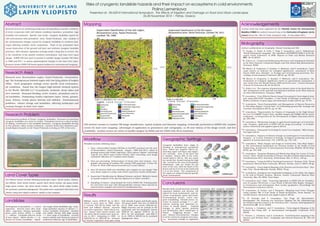
  • 1. Risks of cryogenic landslide hazards and their impact on ecosystems in cold environments Polina Lemenkova Presented at: IRLA2014 International Symposium. The Effects of Irrigation and Drainage on Rural and Urban Landscapes. 26-28 November 2014 | Patras, Greece Abstract Research focuses on monitoring landscapes downgrading in specific conditions of Arctic ecosystems with cold climate conditions (marshes, permafrost, high humidity and moisture). Specific case study: cryogenic landslides typical for cold environments with permafrost. Area: Yamal Peninsula. Aim: analysis of the environmental changes caused by cryogenic landslides in northern land- scapes affecting sensitive Arctic ecosystems. Thaw of the permafrost layer causes destruction of the ground soil layer and activates cryogenic landslide processes. After disaster, vegetation coverage needs a long time to recover, due to the sensitivity of the specific northern environment, and land cover types change. ILWIS GIS was used to process 2 satellite images Landsat TM taken at 1988 and 2011, to assess spatiotemporal changes in the land cover types. Research shown ILWIS GIS based spatial analysis for environmental mapping. Research Area Research area: Bovanenkovo region, Yamal Peninsula. Geomorphol- ogy: flat homogeneous lowland region with low-lying plains of heights <90m. Such geographic settings create specific local environmen- tal conditions. Yamal has the largest high-latitude wetland system in the World: 900,000 km2 of peatlands, wetlands, dense lakes and river network. Seasonal flooding, active erosion, permafrost and lo- cal landslides. Dominating tundra vegetation types: heath, grasses, moss, lichens, woody plants (shrubs and willows). Environmental problems: climate change and landslides, affecting landscapes and causing changes in land cover types. Research Problem Environmental problem of Yamal: cryogenic landslides. Processes of superficial cryogenic landslides are active in tundra. Permafrost serves as a shear surface for sliding, contributes to the landslide formation. Cryogenic landslides develop on fine-grained, saline marine sediments: common destructive disastrous geo- morphological hazards on the Yamal Peninsula covering ca 70% of the area. Land Cover Types The defined classes include following landscapes types: shrub tundra, willows, tall willows, short shrub tundra, sparse short shrub tundra, dry grass heath, sedge grass tundra, dry short shrub tundra, dry short shrub sedge tundra, wet peatland, peatland (sphagnum). The pixels were associated with land cover classes using their digital numbers, similar to key samples. Landslides Development of permafrost => scarce vegetation. Several years after land- slides, vegetation changes gradually: grass, moss, lichen, shrub => sedge => willows. Landslide-affected areas of bare slopes: willow shrubs => in- dicator for former landslides. Vegeta- tion stages show landslides age: early- stage (primitive mosses or lichen) => recent landslide formation; meadow and willow shrubs with high canopy => final stage of landslides. Ground waters salinity and chemical content of sediments indicates age of landslides. Mapping GIS method consists in Landsat TM image classification, spatial analysis and thematic mapping, technically performed in ILIWIS GIS. Landsat scenes for land cover mapping: advantages of application in geosciences and cartography, ca 40 year history of the image record, and free availability. Landsat scenes are series of satellite imagery by NASA and the USGS with 30-m resolution. Workflow Workflow includes following steps: 1. Data: orthorectified Landsat TM files in GeoTIFF acquired over the area of Bovanenkovo, Yamal Peninsula. Images: 1988 and 2011, taken in growing season with visible vegetation. Data capture, import, converting .img file into ASCII raster format (GDAL). After converting, each image contained collection of 7 Landsat raster bands. 2. Data pre-processing: Enhancement of visual color and contrast. Geo- graphic referencing of Landsat TM: setting UTM projection, E Zone 42, N Zone W, WGS 1984 datum (Georeference Corner Editor). 3. Area Of Interest (AOI) was identified and cropped on raw images This area shows region in a large scale which represents tundra landscapes. 4. Supervised Classification by Minimal Distance method. Method is based on spatial analysis of the spectral signatures of object variables. 5. Sampling of classes: using Sample Set tool in ILWIS GIS. Training pixels for each land cover type with distinguishable contrast colors selected as representative samples and stored as classification key. Results Willows covers 2750,57 ha in 2011, which is more than in 1988, when it covered 1547,52 ha (both ’tall wil- lows’ and ’willows’ classes). Increase in tundra vegetation: ’short shrub tun- dra’, ’sparse short shrub tundra’ and ’dry short shrub tundra’ have more ar- eas in 2011 comparing to 1988: ca 5442,00 ha vs 1823,00 ha. Increase of wooden vegetation class goes along with shrunk of grass and heath areas: ’dry grass heath’ had area of 3335.39 ha in 1988, now covers 1204.94 ha. Slight decrease can be noticed in the ’peatlands’ and ’wet peatlands’ classes 3958.40 ha against 2765.41 ha in 2011 by ’wet peatlands’, and 625.71 ha in 1988 vs 488.69 ha by ’peatland (sphagnum)’ class. Geographic Settings Cryogenic landslides have origin in thawing of underground permafrost layer, which has negative effects de- structing upper soil layer and vegeta- tion coverage. Area of the Kara Sea is shallow: almost 40% of the conti- nental shelf is <50 m. The sea coasts are mostly flat, flooded during the high tide. Located in the area of permafrost distribution, soils are frozen for the most of the year, with the depth of the frozen soil up to 0.2 m in the north and 2 m in the south. The ecosystems of the region are adapted towards specific Arctic environment. Conclusions Results show overall increase of woody vegetation (willows and shrubs), not typical for local environment, and de- crease of peatlands, grass and heath. Environmental factors: active cryo- genic landsliding. Climatic factor: in- crease of annual average T => per- mafrost thawing and abnormal in- crease of woody plants. Gradual changes in plant species patterns and distribution affect landscapes in Yamal. Triggering factors: com- plex climatic-environmental changes in Arctic and local cryogenic processes, e.g. successive change in vegetation recovering after cryogenic landslides. Acknowledgements Current work has been supported by the Finnish Center for International Mobility (CIMO) for author’s research stay at the University of Lapland, Arctic Center (Grant No. TM-10-7124), during 01 July - 31 December 2011. Bibliography Author’s publications on Geography, Remote Sensing and GIS: 1 S. Gauger, G. Kuhn, K. Gohl, T. Feigl, P. Lemenkova, and C. Hillenbrand, “Swath-bathymetric mapping”, The expedition ANTARKTIS-XXIII/4 of the Re- search Vessel ’Polarstern’ in 2006. Reports on Polar and Marine Research 557, 38–45 (2007). 2 K. Gohl et al., Crustal and Sedimentary Structures and Geodynamic Evolution of the West Antarctic Continental Margin and Pine Island Bay (Bremerhaven, Germany, 2006). 3 M. Klauˇco, B. Gregorová, U. Stankov, V. Markovi´c, and P. Lemenkova, “Land- scape metrics as indicator for ecological significance: assessment of Sitno Natura 2000 sites, Slovakia”, in Ecology and environmental protection, Pro- ceedings of International Conference (2014), pp. 85–90. 4 M. Klauˇco, B. Gregorová, U. Stankov, V. Markovi´c, and P. Lemenkova, “De- termination of ecological significance based on geostatistical assessment: a case study from the Slovak Natura 2000 protected area”, Central European Journal of Geosciences 5, 28–42 (2013). 5 G. Kuhn et al., The response of quaternary climatic cycles in the South-East Pa- cific: development of the opal belt and dynamics behavior of the West Antarctic ice sheet (Bremerhaven, Germany, 2006). 6 P. Lemenkova, “Cost-Effective Raster Image Processing for Geoecological Anal- ysis using ISOCLUST Classifier: a Case Study of Estonian Landscapes”, in Modern problems of geoecology and landscapes studies (2014), pp. 74–76. 7 P. Lemenkova, “Rural Sustainability and Management of Natural Resources in Tian Shan Region, Central Asia”, in Celebrating pastoral life. heritage and economic development (2014), pp. 81–89. 8 P. Lemenkova, “Opportunities for Classes of Geography in the High School: the Use of ’CORINE’ Project Data, Satellite Images and IDRISI GIS for Geovi- sualization”, in Perspectives for the Development of Higher Education (2014), pp. 284–286. 9 P. Lemenkova, “Monitoring changes in agricultural landscapes of Central Eu- rope, Hungary: application of ILWIS GIS for image processing”, in Geoinfor- matics: theoretical and applied aspects (2013). 10 P. Lemenkova, “Geospatial Technology for Land Cover Analysis”, MEA Geospa- tial Digest (2013). 11 P. Lemenkova, “Impacts of Climate Change on Landscapes in Central Europe, Hungary”, in Current Problems of Ecology, Ecological monitoring and man- agement of natural protection, Vol. 2 (2012), pp. 134–136. 12 P. Lemenkova, “Water Supply and Usage in Central Asia, Tian Shan Basin”, in 4th International Symposium for Doctoral studies in the Fields of Civil Engineering, Architecture & Environmental Protection (PhiDAC-2012) (Sept. 2012), pp. 331–338. 13 P. Lemenkova, “Seagrass Mapping and Monitoring Along the Coasts of Crete, Greece”, M.Sc. Thesis (University of Twente, Faculty of Earth Observation and Geoinformation (ITC), Enschede, Netherlands, Mar. 8, 2011), 158 pp. 14 P. Lemenkova, “Using ArcGIS in Teaching Geosciences”, Russian, B.Sc. Thesis (Lomonosov Moscow State University, Moscow, Russia, June 5, 2007), 58 pp. 15 P. Lemenkova, “Geoecological Mapping of the Barents and Pechora Seas”, Rus- sian, B.Sc. Thesis (Moscow, Russia, 2004), 78 pp. 16 P. Lemenkova, Ecological and Geographical Mapping of the Baltic Sea Region in the Gulf of Finland, Russian, Moscow, Russia: Lomonosov Moscow State University, Mar. 30, 2002, Term Paper. 17 P. Lemenkova and I. Elek, “Clustering Algorithm in ILWIS GIS for Classifica- tion of Landsat TM Scenes: a Case Study of Mecsek Hills Region, Hungary”, in Geosciences and environment, Near-surface geophysics, Proceedings 3rd International Conference (2012). 18 P. Lemenkova, B. Forbes, and T. Kumpula, “Mapping Land Cover Changes Using Landsat TM: A Case Study of Yamal Ecosystems, Arctic Russia”, in Geoinformatics: theoretical and applied aspects (2012). 19 H. W. Schenke and P. Lemenkova, “Zur Frage der Meeresboden- Kartographie: Die Nutzung von AutoTrace Digitizer für die Vektorisierung der Bathymetrischen Daten in der Petschora-See”, German, Hydrographische Nachrichten 25, 16–21 (2008). 20 I. Suetova, L. Ushakova, and P. Lemenkova, “Geoecological Mapping of the Barents Sea Using GIS”, in International Cartographic Conference (ICC) (2005). 21 I. Suetova, L. Ushakova, and P. Lemenkova, “Geoinformation mapping of the Barents and Pechora Seas”, Geography and Natural Resources 4, 138–142 (2005).