SlideShare a Scribd company logo
1 of 1
Download to read offline
Economic assessment of landslide risk
for the Waidhofen a.d. Ybbs region,
Alpine Foreland, Lower Austria
P. Lemenkova, C. Promper & T. Glade
University of Vienna, Institute of Geography and Regional Research, Geomorphic Systems and Risk Research, Vienna, Austria
Fig. 3. Landslides classified by age. Ybbs valley (Source: Petschko et al., 2011) Fig. 4. Elements at risk: buildings, roads and railway lines.
Enlarged: city centre (Data source: Provincial Government of Lower Austria)
Fig. 1.
Geographic location of Waidhofen a.d.Ybbs.
Fig. 2. Surroundings of the Ybbs valley.
Photo: H. Petschko
● The region of Ybbs valley (Fig.2) is located in mountainous Alpine Foreland, Austria.
It covers a total area of 131.3 km2.
The environmental conditions of the the Ybbs valley are especially prone to landslides:
● Geology: deposits of gravel, sand, marl, conglomerate, calcareous sandstone and clay.
● Most of the region is used as pasture, agricultural land, and large forests.
● Climatic humid to continental. Intensive rainfalls in spring and autumn months.
● The region is attractive for tourists due to its environmental and historical value.
Type of factors Thematic layers
Anthropogenic
Roads (railway, highways)
Areas of demolishing & dismantling
Areas of construction work
Settlements
Topographic
Orthophotos
DEM (1m and 3m resolution), DTM
Vector relief map
Environmental
Watershed areas
Water catchment areas
Landscape protected zones
Areas of NATURA-2000
Geological vector map
Natural protected zones; forests; parks.
Tab. 1. Data Structure
Types of investment Constructio
n
cost, €/year),
one house
Total costs,
all houses (*)
Demolition cost(concrete masonry), €/m
3
(a)
87 -
Average volume to demolish, m
3
(b)
189,32 -
Mechanical excavation costs, €/m
3
(c) 25.5 -
Total (€) to demolish walls,
concrete masonry = (a*b)+(c*b)
21,298 13,652,338
Transport and disposal debris, €/m² (**) 26 3,608,462
Inner walls restoration costs (€/m
2
)
7 -
Average surface of inner walls (m
2
)
607 -
Average charge to restore inner walls (€) 4,252 2,725,852
Average price to restore furniture, €/m
2
(x)
600 -
Average house base area, m
2
, (y)
317 -
Total average charge (€) to restore furniture
(x*y)
190,500 122,110,500
Average house base area, m
2
, (y)
317 -
Average cost to build a house (€/m
3
)
1,100 -
Total average charge to build a house, € 349,250 223,869,250
Total complete average charge
(demolition + restoration), €
216,051 138,488,691
(*) Number of houses at risk in Ybbs valley = 641
(**) Total area of buildings at risk, m2 = 138
Type of investment Construction
cost
Length
(m)
Total losses (€)
Railway tracks, (€/m)
restoration (*)
4,200 20,953 A = 88,005,204
Road rebuilding, €/m (**) 4,131
13,541
(length in
Ybbs
valley)
B = 55,948,749
Debris excavation (a) 17
Debris removal (b) 25
Transportation& storage (c) 26
Roads restoration, (a)+(b)+
(c), €/m2 (***)
68.0 C = 927,590
Total possible direct damages (A+B+C) = 144,881,544
(*) Source: Zischg et al., 2005 (**) Source: Giacometti, 2005. (***) Source: Sterlacchini et al., 2007
Tab. 3. Real estate destruction losses, Ybbs valley,
as for average market value (Source: Giacometti, 2005).
Tab. 2. Estimation of possible monetary losses for transport.
DATA
METHODS
RESULTS
● Source: the data used in this research were generously provided by the Provincial Government of Lower Austria.
● Content: data include vector thematic layers covering the area, aerial imagery, topographic vector layers and maps.
● Organization: data have been organized in a ArcCatalog database and sorted according to their types (Tab.1).
● Compatibility: all data have been stored in the ArcGIS project in Austrian National grid Austria Bundesmeldenetz (BMN) M34.
CONCLUSION
REFERENCES
● Bell, R. & Glade, T. 2004. Quantitative risk analysis for landslides – Examples from Bildudalur, NW-Iceland. Natural Hazards
and Earth System Sciences 4: 117–131 SRef-ID: 1684-9981/nhess/2004-4-117
● Bellos, P., Frank, G. & Hochbichler, E. 2006. Waldbauliche Bewirtschaftungsrichtlinien für das Einzugsgebiet der Ybbs im
Rahmen eines nachhaltigen Naturraummanagements (Endbericht). Forschungsprojekt: GZ BMLFUW LE.3.2/0021-IV/2004
● Cruden, D.M. & Fell, R. (eds) 1997. Landslide Risk Assessment. Proceedings of the international workshop on landslide risk
assessment / Hawaii / USA.
● Giacometti, P. (ed.) 2005. Economic Evaluation of Risk. ALARM Project (Assessment on Landslide Risk and Mitigation in
Mountain Area). Aracne. EU Commission. The Fifth Framework Programme.
● Glade, T., Anderson, M. & Crozier, M.J. (eds.) 2005. Landslide Hazard and Risk. John Wiley & Sons, Ltd.
● Hartlen, J. & Viberg, L. 1988. General report: Evaluation of Landslide Hazard. Proceedings 5th Int. Symposium on Landslides,
Lausanne. Vol.2, 1037-1057.
● Heinimann, H.R. 1999. Risikoanalyse bei gravitativen Naturgefahren - Methode. Umwelt-Materialen, 107/1, Bern.
● Lee, E.M. & Jones, D.K.C. 2004. Landslide Risk Assessment. Thomas Telford.
● Petschko H., Bell R., Brenning A. & Glade T. 2011. Modelling landslide susceptibility in large and heterogeneous regions with
generalized additive models: case study Lower Austria. Contributed to the project MoNOE at EGU-2011, Vienna.
● Sterlacchini, S., Frigerio S., Giacomelli P. & Brambilla M. 2007. Landslide risk analysis: a multidisciplinary methodological
approach. Nat. Hazards 7, 657-675.
● Zischg, A., Fuchs, S., Keiler M., & Stötter, J. 2005. Temporal variability of damage potential on roads as a conceptual
contribution towards a short-term avalanche risk simulation. Natural Hazards, 5, 235–242.
ACKNOWLEDGEMENTS
The GIS data were provided by the Provincial Government of the Lower Austria. We thank assistance of H.Petschko.
The financial support was provided by the Austrian Academic Exchange Service of the Republic of Austria,
Austrian Federal Minister for Science and Research (ÖAD).
RESEARCH AREA
PERSPECTIVES AND RECOMMENDATIONS
In view of the uncertainties in risk assessment, flexible combination of research approaches is desirable:
landslide hazard modeling and application of various methodologies to study area.
Buffer zones have to be validated and empirically tested during fieldworks.
Data from cadastral and statistical information sources could enable vulnerability assessment.
The geographic location of landslides within the Ybbs valley was defined by H.Petschko. We used these results (Fig.3) for defining risk zones.
1) Risk zone: 100-meter buffer area surrounding all landslides downwards, as a landslide with volume of 1 km³ may reach 100 meters while moving.
2) Elements at risk: The objects located in the 100 meter distance downwards the landslides are regarded as elements at risk.
3) Estimation of the economic losses: The methodology is proposed by Giacometti (2005) was applied for Ybbs valley using real estate prices for common goods (immobility, roads).
Calculations of the economic losses (in €) was done based on the average real estate prices for various aspects of renovation, reconstruction and rebuilding of the destroyed objects.
● Defining elements at risk
The elements at risk were selected in 100-meter buffer area near the landslides (Fig. 4).
The length and number of the elements at risk within the distance of 100 m near landslides totals to 20.9 km of railway lines, 13.5 km of roads and 641 buildings.
● Calculation the economic losses
The calculation of the real estate losses is computed from the calculation of five different types of costs (Tab. 3): 1) demolition, 2) transport and disposal debris, 3) restoration of inner
walls, 4) furniture restoration and 5) house construction. The average volume to demolish damaged buildings indicated the dimensions of the losses of ca. 13.65 M €.
The research focuses on the monetary estimation of the possible losses caused by landslides.
Estimation of the economic damages is performed using existing simplified methodologies.
Calculations were based on real estate and market price of the elements at risk.
While assessing potential damage of landslides confusion arises due to these factors.
1. First, the temporal probability of the landslides occurrence is highly difficult to assess: it can only
be estimated based on the reliable and obtainable data. This includes historical data continuously
reporting the occurrence of the landslides.
2. Secondly, difficulties arise by estimation of the indirect losses and partially damaged objects. The
amount of the damages can be assessed based on elements vulnerability, which is very uncertain to
estimate exactly. Thus, the vulnerability may differ depending on object location, individual
characteristics and external factors.
3. The term “landslide” is not differentiated between debris flows and
shallow or rotational landslides. This is an important source for uncertainty, as movement
characteristics of these landslides are different.
4. Confusing over different method approaches in the risk assessment may generate various results:
difference in magnitude and occurrence of landslides, risk perception and vulnerability assessment.
The estimation of landslide risk should be based on complex investigations.
The data about landslide probability should be gained from monitoring programmes.
The elements at risk are defined based on spatial analysis and infrastructure inventory.
The vulnerability estimation should include census data and social questionnaire.
The real-life situations may vary depending on the exact price of the individual object.
The estimated price for the debris removal is approx. 3.6 M €, in case buildings are totally affected and covered.
The restoration of the inner walls is based on average prices for building restoration and approximate surface of the walls, which totally estimates 2.73 M €.
Using approximate prices of the furniture costs (Giacometti, 2005) in a typical house the costs for furniture renovation is € 190,500.
Cost for house construction is computed using real estate prices and average house area in m² which sums up to € 349,250.
The losses for transport (Tab. 2) include costs to rebuild a road, a railway, and a restoration of the roads.
A total of almost 140 M € would have to be invested for the renovation of the Ybbs valley in case of a landslides disaster (Tab.3).
This research aims to assess potential risk and estimate economic damage caused by landslides. The study area is located in the Ybbs valley, Lower Austria (Fig.1).
Methodology consists of Arc GIS based spatial analysis and estimation of the potential monetary losses caused by landslides.
Spatial analysis was used for defining elements at risk located in the risk zone of 100 m near landslides, and assessment of potential consequences.
Results: calculated possible losses caused by the destruction of immobility and transport: costs for buildings demolition, restoration, roads rebuilding, debris transport, excavation and removal.
INTRODUCTION

More Related Content

Similar to Economic assessment of landslide risk for the Waidhofen a.d. Ybbs region, Alpine Foreland, Lower Austria

Research Project: Multihazard and vulnerability in the seismic context of the...
Research Project: Multihazard and vulnerability in the seismic context of the...Research Project: Multihazard and vulnerability in the seismic context of the...
Research Project: Multihazard and vulnerability in the seismic context of the...
guest76176b
 
IGARSS11_Stramondo.ppt
IGARSS11_Stramondo.pptIGARSS11_Stramondo.ppt
IGARSS11_Stramondo.ppt
grssieee
 
IGARSS11_Stramondo.ppt
IGARSS11_Stramondo.pptIGARSS11_Stramondo.ppt
IGARSS11_Stramondo.ppt
grssieee
 
land use planning - natech risks
land use planning - natech risksland use planning - natech risks
land use planning - natech risks
Anna Papachatzi
 

Similar to Economic assessment of landslide risk for the Waidhofen a.d. Ybbs region, Alpine Foreland, Lower Austria (20)

Risks reading1
Risks reading1Risks reading1
Risks reading1
 
Risks reading1
Risks reading1Risks reading1
Risks reading1
 
Research Project: Multihazard and vulnerability in the seismic context of the...
Research Project: Multihazard and vulnerability in the seismic context of the...Research Project: Multihazard and vulnerability in the seismic context of the...
Research Project: Multihazard and vulnerability in the seismic context of the...
 
IGARSS11_Stramondo.ppt
IGARSS11_Stramondo.pptIGARSS11_Stramondo.ppt
IGARSS11_Stramondo.ppt
 
IGARSS11_Stramondo.ppt
IGARSS11_Stramondo.pptIGARSS11_Stramondo.ppt
IGARSS11_Stramondo.ppt
 
LANDSLIDE SUSCEPTIBILITY MAPPING OF THE AITOLOAKARNANIA AND EVRYTANIA REGIONA...
LANDSLIDE SUSCEPTIBILITY MAPPING OF THE AITOLOAKARNANIA AND EVRYTANIA REGIONA...LANDSLIDE SUSCEPTIBILITY MAPPING OF THE AITOLOAKARNANIA AND EVRYTANIA REGIONA...
LANDSLIDE SUSCEPTIBILITY MAPPING OF THE AITOLOAKARNANIA AND EVRYTANIA REGIONA...
 
Hazard mapping
Hazard mappingHazard mapping
Hazard mapping
 
Sachpazis: Geotechnical aspects of a Landfill site Selection Study in North E...
Sachpazis: Geotechnical aspects of a Landfill site Selection Study in North E...Sachpazis: Geotechnical aspects of a Landfill site Selection Study in North E...
Sachpazis: Geotechnical aspects of a Landfill site Selection Study in North E...
 
Assessment Of Desertification In Semi-Arid Mediterranean Environments The Ca...
Assessment Of Desertification In Semi-Arid Mediterranean Environments  The Ca...Assessment Of Desertification In Semi-Arid Mediterranean Environments  The Ca...
Assessment Of Desertification In Semi-Arid Mediterranean Environments The Ca...
 
Application of GIS in Mine Contamination and Associated Environmental Impacts
Application of GIS in Mine Contamination and Associated Environmental ImpactsApplication of GIS in Mine Contamination and Associated Environmental Impacts
Application of GIS in Mine Contamination and Associated Environmental Impacts
 
environments-06-00082-v2.pdf
environments-06-00082-v2.pdfenvironments-06-00082-v2.pdf
environments-06-00082-v2.pdf
 
Mapping Land Cover Changes Using Landsat TM: a Case Study of Yamal Ecosystems...
Mapping Land Cover Changes Using Landsat TM: a Case Study of Yamal Ecosystems...Mapping Land Cover Changes Using Landsat TM: a Case Study of Yamal Ecosystems...
Mapping Land Cover Changes Using Landsat TM: a Case Study of Yamal Ecosystems...
 
International Journal of Engineering Research and Development
International Journal of Engineering Research and DevelopmentInternational Journal of Engineering Research and Development
International Journal of Engineering Research and Development
 
B1080817
B1080817B1080817
B1080817
 
IRJET-Investigation of Landslides and its Effects on Kothagiri
IRJET-Investigation of Landslides and its Effects on KothagiriIRJET-Investigation of Landslides and its Effects on Kothagiri
IRJET-Investigation of Landslides and its Effects on Kothagiri
 
land use planning - natech risks
land use planning - natech risksland use planning - natech risks
land use planning - natech risks
 
Bridge pgd sbornik 2017 web
Bridge pgd sbornik 2017 webBridge pgd sbornik 2017 web
Bridge pgd sbornik 2017 web
 
Remote Sensing Presentation
Remote Sensing PresentationRemote Sensing Presentation
Remote Sensing Presentation
 
Determining Important Grade of Environmental Risk Factors at Slopes
Determining Important Grade of Environmental Risk Factors at SlopesDetermining Important Grade of Environmental Risk Factors at Slopes
Determining Important Grade of Environmental Risk Factors at Slopes
 
Methodology of Assessment Vulnerability of Soil Cover in Slovakia
Methodology of Assessment Vulnerability of Soil Cover in SlovakiaMethodology of Assessment Vulnerability of Soil Cover in Slovakia
Methodology of Assessment Vulnerability of Soil Cover in Slovakia
 

More from Universität Salzburg

Bringing Geospatial Analysis to the Social Studies: an Assessment of the City...
Bringing Geospatial Analysis to the Social Studies: an Assessment of the City...Bringing Geospatial Analysis to the Social Studies: an Assessment of the City...
Bringing Geospatial Analysis to the Social Studies: an Assessment of the City...
Universität Salzburg
 
Detection of Vegetation Coverage in Urban Agglomeration of Brussels by NDVI I...
Detection of Vegetation Coverage in Urban Agglomeration of Brussels by NDVI I...Detection of Vegetation Coverage in Urban Agglomeration of Brussels by NDVI I...
Detection of Vegetation Coverage in Urban Agglomeration of Brussels by NDVI I...
Universität Salzburg
 
Investigation of the Lake Victoria Region (Africa: Tanzania, Kenya and Uganda)
Investigation of the Lake Victoria Region (Africa: Tanzania, Kenya and Uganda)Investigation of the Lake Victoria Region (Africa: Tanzania, Kenya and Uganda)
Investigation of the Lake Victoria Region (Africa: Tanzania, Kenya and Uganda)
Universität Salzburg
 
Interpretation of Landscape Values, Typology and Quality Using Methods of Spa...
Interpretation of Landscape Values, Typology and Quality Using Methods of Spa...Interpretation of Landscape Values, Typology and Quality Using Methods of Spa...
Interpretation of Landscape Values, Typology and Quality Using Methods of Spa...
Universität Salzburg
 
Quality assessment of data from CHRIS/PROBA
Quality assessment of data from CHRIS/PROBAQuality assessment of data from CHRIS/PROBA
Quality assessment of data from CHRIS/PROBA
Universität Salzburg
 
Seagrass mapping and monitoring along the coast of Crete, Greece
Seagrass mapping and monitoring along the coast of Crete, GreeceSeagrass mapping and monitoring along the coast of Crete, Greece
Seagrass mapping and monitoring along the coast of Crete, Greece
Universität Salzburg
 
Why Should We Stand for Geothermal Energy ? Example of the Negative Impacts o...
Why Should We Stand for Geothermal Energy ? Example of the Negative Impacts o...Why Should We Stand for Geothermal Energy ? Example of the Negative Impacts o...
Why Should We Stand for Geothermal Energy ? Example of the Negative Impacts o...
Universität Salzburg
 
Urban Sprawl in Estonia
Urban Sprawl in EstoniaUrban Sprawl in Estonia
Urban Sprawl in Estonia
Universität Salzburg
 
Using K-means algorithm classifier for urban landscapes classification in Tai...
Using K-means algorithm classifier for urban landscapes classification in Tai...Using K-means algorithm classifier for urban landscapes classification in Tai...
Using K-means algorithm classifier for urban landscapes classification in Tai...
Universität Salzburg
 
Rural Sustainability and Management of Natural Resources in Tian Shan Region,...
Rural Sustainability and Management of Natural Resources in Tian Shan Region,...Rural Sustainability and Management of Natural Resources in Tian Shan Region,...
Rural Sustainability and Management of Natural Resources in Tian Shan Region,...
Universität Salzburg
 
Seagrass Mapping and Monitoring Along the Coasts of Crete, Greece
Seagrass Mapping and Monitoring Along the Coasts of Crete, GreeceSeagrass Mapping and Monitoring Along the Coasts of Crete, Greece
Seagrass Mapping and Monitoring Along the Coasts of Crete, Greece
Universität Salzburg
 
Data Sharing, Distribution and Updating Using Social Coding Community Github ...
Data Sharing, Distribution and Updating Using Social Coding Community Github ...Data Sharing, Distribution and Updating Using Social Coding Community Github ...
Data Sharing, Distribution and Updating Using Social Coding Community Github ...
Universität Salzburg
 
Seagrass Mapping and Monitoring Along the Coasts of Crete, Greece. MSc Thesis...
Seagrass Mapping and Monitoring Along the Coasts of Crete, Greece. MSc Thesis...Seagrass Mapping and Monitoring Along the Coasts of Crete, Greece. MSc Thesis...
Seagrass Mapping and Monitoring Along the Coasts of Crete, Greece. MSc Thesis...
Universität Salzburg
 

More from Universität Salzburg (20)

Accurate and rapid big spatial data processing by scripting cartographic algo...
Accurate and rapid big spatial data processing by scripting cartographic algo...Accurate and rapid big spatial data processing by scripting cartographic algo...
Accurate and rapid big spatial data processing by scripting cartographic algo...
 
Presentation lemenkova
Presentation lemenkovaPresentation lemenkova
Presentation lemenkova
 
Risks of Cryogenic Landslide Hazards and Their Impact on Ecosystems in Cold E...
Risks of Cryogenic Landslide Hazards and Their Impact on Ecosystems in Cold E...Risks of Cryogenic Landslide Hazards and Their Impact on Ecosystems in Cold E...
Risks of Cryogenic Landslide Hazards and Their Impact on Ecosystems in Cold E...
 
Bringing Geospatial Analysis to the Social Studies: an Assessment of the City...
Bringing Geospatial Analysis to the Social Studies: an Assessment of the City...Bringing Geospatial Analysis to the Social Studies: an Assessment of the City...
Bringing Geospatial Analysis to the Social Studies: an Assessment of the City...
 
Detection of Vegetation Coverage in Urban Agglomeration of Brussels by NDVI I...
Detection of Vegetation Coverage in Urban Agglomeration of Brussels by NDVI I...Detection of Vegetation Coverage in Urban Agglomeration of Brussels by NDVI I...
Detection of Vegetation Coverage in Urban Agglomeration of Brussels by NDVI I...
 
Investigation of the Lake Victoria Region (Africa: Tanzania, Kenya and Uganda)
Investigation of the Lake Victoria Region (Africa: Tanzania, Kenya and Uganda)Investigation of the Lake Victoria Region (Africa: Tanzania, Kenya and Uganda)
Investigation of the Lake Victoria Region (Africa: Tanzania, Kenya and Uganda)
 
Interpretation of Landscape Values, Typology and Quality Using Methods of Spa...
Interpretation of Landscape Values, Typology and Quality Using Methods of Spa...Interpretation of Landscape Values, Typology and Quality Using Methods of Spa...
Interpretation of Landscape Values, Typology and Quality Using Methods of Spa...
 
Quality assessment of data from CHRIS/PROBA
Quality assessment of data from CHRIS/PROBAQuality assessment of data from CHRIS/PROBA
Quality assessment of data from CHRIS/PROBA
 
Conservation Area Designation in the Andes
Conservation Area Designation in the AndesConservation Area Designation in the Andes
Conservation Area Designation in the Andes
 
Seagrass mapping and monitoring along the coast of Crete, Greece
Seagrass mapping and monitoring along the coast of Crete, GreeceSeagrass mapping and monitoring along the coast of Crete, Greece
Seagrass mapping and monitoring along the coast of Crete, Greece
 
Why Should We Stand for Geothermal Energy ? Example of the Negative Impacts o...
Why Should We Stand for Geothermal Energy ? Example of the Negative Impacts o...Why Should We Stand for Geothermal Energy ? Example of the Negative Impacts o...
Why Should We Stand for Geothermal Energy ? Example of the Negative Impacts o...
 
Using ArcGIS in Teaching Geosciences
Using ArcGIS in Teaching GeosciencesUsing ArcGIS in Teaching Geosciences
Using ArcGIS in Teaching Geosciences
 
How could obligation chain be structured along cross-border gas supply for...
   How could obligation chain be structured along cross-border gas supply for...   How could obligation chain be structured along cross-border gas supply for...
How could obligation chain be structured along cross-border gas supply for...
 
Urban Sprawl in Estonia
Urban Sprawl in EstoniaUrban Sprawl in Estonia
Urban Sprawl in Estonia
 
Using K-means algorithm classifier for urban landscapes classification in Tai...
Using K-means algorithm classifier for urban landscapes classification in Tai...Using K-means algorithm classifier for urban landscapes classification in Tai...
Using K-means algorithm classifier for urban landscapes classification in Tai...
 
Rural Sustainability and Management of Natural Resources in Tian Shan Region,...
Rural Sustainability and Management of Natural Resources in Tian Shan Region,...Rural Sustainability and Management of Natural Resources in Tian Shan Region,...
Rural Sustainability and Management of Natural Resources in Tian Shan Region,...
 
Mapping Agricultural Lands by Means of GIS for Monitoring Use of Natural Reso...
Mapping Agricultural Lands by Means of GIS for Monitoring Use of Natural Reso...Mapping Agricultural Lands by Means of GIS for Monitoring Use of Natural Reso...
Mapping Agricultural Lands by Means of GIS for Monitoring Use of Natural Reso...
 
Seagrass Mapping and Monitoring Along the Coasts of Crete, Greece
Seagrass Mapping and Monitoring Along the Coasts of Crete, GreeceSeagrass Mapping and Monitoring Along the Coasts of Crete, Greece
Seagrass Mapping and Monitoring Along the Coasts of Crete, Greece
 
Data Sharing, Distribution and Updating Using Social Coding Community Github ...
Data Sharing, Distribution and Updating Using Social Coding Community Github ...Data Sharing, Distribution and Updating Using Social Coding Community Github ...
Data Sharing, Distribution and Updating Using Social Coding Community Github ...
 
Seagrass Mapping and Monitoring Along the Coasts of Crete, Greece. MSc Thesis...
Seagrass Mapping and Monitoring Along the Coasts of Crete, Greece. MSc Thesis...Seagrass Mapping and Monitoring Along the Coasts of Crete, Greece. MSc Thesis...
Seagrass Mapping and Monitoring Along the Coasts of Crete, Greece. MSc Thesis...
 

Recently uploaded

Call Now ☎ Russian Call Girls Connaught Place @ 9899900591 # Russian Escorts ...
Call Now ☎ Russian Call Girls Connaught Place @ 9899900591 # Russian Escorts ...Call Now ☎ Russian Call Girls Connaught Place @ 9899900591 # Russian Escorts ...
Call Now ☎ Russian Call Girls Connaught Place @ 9899900591 # Russian Escorts ...
kauryashika82
 

Recently uploaded (20)

VIP Model Call Girls Wagholi ( Pune ) Call ON 8005736733 Starting From 5K to ...
VIP Model Call Girls Wagholi ( Pune ) Call ON 8005736733 Starting From 5K to ...VIP Model Call Girls Wagholi ( Pune ) Call ON 8005736733 Starting From 5K to ...
VIP Model Call Girls Wagholi ( Pune ) Call ON 8005736733 Starting From 5K to ...
 
CSR_Module5_Green Earth Initiative, Tree Planting Day
CSR_Module5_Green Earth Initiative, Tree Planting DayCSR_Module5_Green Earth Initiative, Tree Planting Day
CSR_Module5_Green Earth Initiative, Tree Planting Day
 
Call Now ☎ Russian Call Girls Connaught Place @ 9899900591 # Russian Escorts ...
Call Now ☎ Russian Call Girls Connaught Place @ 9899900591 # Russian Escorts ...Call Now ☎ Russian Call Girls Connaught Place @ 9899900591 # Russian Escorts ...
Call Now ☎ Russian Call Girls Connaught Place @ 9899900591 # Russian Escorts ...
 
Call Girls Moshi Call Me 7737669865 Budget Friendly No Advance Booking
Call Girls Moshi Call Me 7737669865 Budget Friendly No Advance BookingCall Girls Moshi Call Me 7737669865 Budget Friendly No Advance Booking
Call Girls Moshi Call Me 7737669865 Budget Friendly No Advance Booking
 
Get Premium Hoskote Call Girls (8005736733) 24x7 Rate 15999 with A/c Room Cas...
Get Premium Hoskote Call Girls (8005736733) 24x7 Rate 15999 with A/c Room Cas...Get Premium Hoskote Call Girls (8005736733) 24x7 Rate 15999 with A/c Room Cas...
Get Premium Hoskote Call Girls (8005736733) 24x7 Rate 15999 with A/c Room Cas...
 
NO1 Verified kala jadu karne wale ka contact number kala jadu karne wale baba...
NO1 Verified kala jadu karne wale ka contact number kala jadu karne wale baba...NO1 Verified kala jadu karne wale ka contact number kala jadu karne wale baba...
NO1 Verified kala jadu karne wale ka contact number kala jadu karne wale baba...
 
GENUINE Babe,Call Girls IN Chhatarpur Delhi | +91-8377877756
GENUINE Babe,Call Girls IN Chhatarpur Delhi | +91-8377877756GENUINE Babe,Call Girls IN Chhatarpur Delhi | +91-8377877756
GENUINE Babe,Call Girls IN Chhatarpur Delhi | +91-8377877756
 
Call Girls Jejuri Call Me 7737669865 Budget Friendly No Advance Booking
Call Girls Jejuri Call Me 7737669865 Budget Friendly No Advance BookingCall Girls Jejuri Call Me 7737669865 Budget Friendly No Advance Booking
Call Girls Jejuri Call Me 7737669865 Budget Friendly No Advance Booking
 
Call Girls Ramtek Call Me 7737669865 Budget Friendly No Advance Booking
Call Girls Ramtek Call Me 7737669865 Budget Friendly No Advance BookingCall Girls Ramtek Call Me 7737669865 Budget Friendly No Advance Booking
Call Girls Ramtek Call Me 7737669865 Budget Friendly No Advance Booking
 
Hot Call Girls |Delhi |Preet Vihar ☎ 9711199171 Book Your One night Stand
Hot Call Girls |Delhi |Preet Vihar ☎ 9711199171 Book Your One night StandHot Call Girls |Delhi |Preet Vihar ☎ 9711199171 Book Your One night Stand
Hot Call Girls |Delhi |Preet Vihar ☎ 9711199171 Book Your One night Stand
 
CSR_Tested activities in the classroom -EN
CSR_Tested activities in the classroom -ENCSR_Tested activities in the classroom -EN
CSR_Tested activities in the classroom -EN
 
Book Sex Workers Available Pune Call Girls Kondhwa 6297143586 Call Hot India...
Book Sex Workers Available Pune Call Girls Kondhwa  6297143586 Call Hot India...Book Sex Workers Available Pune Call Girls Kondhwa  6297143586 Call Hot India...
Book Sex Workers Available Pune Call Girls Kondhwa 6297143586 Call Hot India...
 
Call Girls In Okhla DELHI ~9654467111~ Short 1500 Night 6000
Call Girls In Okhla DELHI ~9654467111~ Short 1500 Night 6000Call Girls In Okhla DELHI ~9654467111~ Short 1500 Night 6000
Call Girls In Okhla DELHI ~9654467111~ Short 1500 Night 6000
 
Kondhwa ( Call Girls ) Pune 6297143586 Hot Model With Sexy Bhabi Ready For ...
Kondhwa ( Call Girls ) Pune  6297143586  Hot Model With Sexy Bhabi Ready For ...Kondhwa ( Call Girls ) Pune  6297143586  Hot Model With Sexy Bhabi Ready For ...
Kondhwa ( Call Girls ) Pune 6297143586 Hot Model With Sexy Bhabi Ready For ...
 
VIP Model Call Girls Chakan ( Pune ) Call ON 8005736733 Starting From 5K to 2...
VIP Model Call Girls Chakan ( Pune ) Call ON 8005736733 Starting From 5K to 2...VIP Model Call Girls Chakan ( Pune ) Call ON 8005736733 Starting From 5K to 2...
VIP Model Call Girls Chakan ( Pune ) Call ON 8005736733 Starting From 5K to 2...
 
VIP Model Call Girls Viman Nagar ( Pune ) Call ON 8005736733 Starting From 5K...
VIP Model Call Girls Viman Nagar ( Pune ) Call ON 8005736733 Starting From 5K...VIP Model Call Girls Viman Nagar ( Pune ) Call ON 8005736733 Starting From 5K...
VIP Model Call Girls Viman Nagar ( Pune ) Call ON 8005736733 Starting From 5K...
 
VVIP Pune Call Girls Koregaon Park (7001035870) Pune Escorts Nearby with Comp...
VVIP Pune Call Girls Koregaon Park (7001035870) Pune Escorts Nearby with Comp...VVIP Pune Call Girls Koregaon Park (7001035870) Pune Escorts Nearby with Comp...
VVIP Pune Call Girls Koregaon Park (7001035870) Pune Escorts Nearby with Comp...
 
RATING SYSTEMS- IGBC, GRIHA, LEED--.pptx
RATING  SYSTEMS- IGBC, GRIHA, LEED--.pptxRATING  SYSTEMS- IGBC, GRIHA, LEED--.pptx
RATING SYSTEMS- IGBC, GRIHA, LEED--.pptx
 
(NEHA) Call Girls Navi Mumbai Call Now 8250077686 Navi Mumbai Escorts 24x7
(NEHA) Call Girls Navi Mumbai Call Now 8250077686 Navi Mumbai Escorts 24x7(NEHA) Call Girls Navi Mumbai Call Now 8250077686 Navi Mumbai Escorts 24x7
(NEHA) Call Girls Navi Mumbai Call Now 8250077686 Navi Mumbai Escorts 24x7
 
DENR EPR Law Compliance Updates April 2024
DENR EPR Law Compliance Updates April 2024DENR EPR Law Compliance Updates April 2024
DENR EPR Law Compliance Updates April 2024
 

Economic assessment of landslide risk for the Waidhofen a.d. Ybbs region, Alpine Foreland, Lower Austria

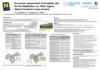
  • 1. Economic assessment of landslide risk for the Waidhofen a.d. Ybbs region, Alpine Foreland, Lower Austria P. Lemenkova, C. Promper & T. Glade University of Vienna, Institute of Geography and Regional Research, Geomorphic Systems and Risk Research, Vienna, Austria Fig. 3. Landslides classified by age. Ybbs valley (Source: Petschko et al., 2011) Fig. 4. Elements at risk: buildings, roads and railway lines. Enlarged: city centre (Data source: Provincial Government of Lower Austria) Fig. 1. Geographic location of Waidhofen a.d.Ybbs. Fig. 2. Surroundings of the Ybbs valley. Photo: H. Petschko ● The region of Ybbs valley (Fig.2) is located in mountainous Alpine Foreland, Austria. It covers a total area of 131.3 km2. The environmental conditions of the the Ybbs valley are especially prone to landslides: ● Geology: deposits of gravel, sand, marl, conglomerate, calcareous sandstone and clay. ● Most of the region is used as pasture, agricultural land, and large forests. ● Climatic humid to continental. Intensive rainfalls in spring and autumn months. ● The region is attractive for tourists due to its environmental and historical value. Type of factors Thematic layers Anthropogenic Roads (railway, highways) Areas of demolishing & dismantling Areas of construction work Settlements Topographic Orthophotos DEM (1m and 3m resolution), DTM Vector relief map Environmental Watershed areas Water catchment areas Landscape protected zones Areas of NATURA-2000 Geological vector map Natural protected zones; forests; parks. Tab. 1. Data Structure Types of investment Constructio n cost, €/year), one house Total costs, all houses (*) Demolition cost(concrete masonry), €/m 3 (a) 87 - Average volume to demolish, m 3 (b) 189,32 - Mechanical excavation costs, €/m 3 (c) 25.5 - Total (€) to demolish walls, concrete masonry = (a*b)+(c*b) 21,298 13,652,338 Transport and disposal debris, €/m² (**) 26 3,608,462 Inner walls restoration costs (€/m 2 ) 7 - Average surface of inner walls (m 2 ) 607 - Average charge to restore inner walls (€) 4,252 2,725,852 Average price to restore furniture, €/m 2 (x) 600 - Average house base area, m 2 , (y) 317 - Total average charge (€) to restore furniture (x*y) 190,500 122,110,500 Average house base area, m 2 , (y) 317 - Average cost to build a house (€/m 3 ) 1,100 - Total average charge to build a house, € 349,250 223,869,250 Total complete average charge (demolition + restoration), € 216,051 138,488,691 (*) Number of houses at risk in Ybbs valley = 641 (**) Total area of buildings at risk, m2 = 138 Type of investment Construction cost Length (m) Total losses (€) Railway tracks, (€/m) restoration (*) 4,200 20,953 A = 88,005,204 Road rebuilding, €/m (**) 4,131 13,541 (length in Ybbs valley) B = 55,948,749 Debris excavation (a) 17 Debris removal (b) 25 Transportation& storage (c) 26 Roads restoration, (a)+(b)+ (c), €/m2 (***) 68.0 C = 927,590 Total possible direct damages (A+B+C) = 144,881,544 (*) Source: Zischg et al., 2005 (**) Source: Giacometti, 2005. (***) Source: Sterlacchini et al., 2007 Tab. 3. Real estate destruction losses, Ybbs valley, as for average market value (Source: Giacometti, 2005). Tab. 2. Estimation of possible monetary losses for transport. DATA METHODS RESULTS ● Source: the data used in this research were generously provided by the Provincial Government of Lower Austria. ● Content: data include vector thematic layers covering the area, aerial imagery, topographic vector layers and maps. ● Organization: data have been organized in a ArcCatalog database and sorted according to their types (Tab.1). ● Compatibility: all data have been stored in the ArcGIS project in Austrian National grid Austria Bundesmeldenetz (BMN) M34. CONCLUSION REFERENCES ● Bell, R. & Glade, T. 2004. Quantitative risk analysis for landslides – Examples from Bildudalur, NW-Iceland. Natural Hazards and Earth System Sciences 4: 117–131 SRef-ID: 1684-9981/nhess/2004-4-117 ● Bellos, P., Frank, G. & Hochbichler, E. 2006. Waldbauliche Bewirtschaftungsrichtlinien für das Einzugsgebiet der Ybbs im Rahmen eines nachhaltigen Naturraummanagements (Endbericht). Forschungsprojekt: GZ BMLFUW LE.3.2/0021-IV/2004 ● Cruden, D.M. & Fell, R. (eds) 1997. Landslide Risk Assessment. Proceedings of the international workshop on landslide risk assessment / Hawaii / USA. ● Giacometti, P. (ed.) 2005. Economic Evaluation of Risk. ALARM Project (Assessment on Landslide Risk and Mitigation in Mountain Area). Aracne. EU Commission. The Fifth Framework Programme. ● Glade, T., Anderson, M. & Crozier, M.J. (eds.) 2005. Landslide Hazard and Risk. John Wiley & Sons, Ltd. ● Hartlen, J. & Viberg, L. 1988. General report: Evaluation of Landslide Hazard. Proceedings 5th Int. Symposium on Landslides, Lausanne. Vol.2, 1037-1057. ● Heinimann, H.R. 1999. Risikoanalyse bei gravitativen Naturgefahren - Methode. Umwelt-Materialen, 107/1, Bern. ● Lee, E.M. & Jones, D.K.C. 2004. Landslide Risk Assessment. Thomas Telford. ● Petschko H., Bell R., Brenning A. & Glade T. 2011. Modelling landslide susceptibility in large and heterogeneous regions with generalized additive models: case study Lower Austria. Contributed to the project MoNOE at EGU-2011, Vienna. ● Sterlacchini, S., Frigerio S., Giacomelli P. & Brambilla M. 2007. Landslide risk analysis: a multidisciplinary methodological approach. Nat. Hazards 7, 657-675. ● Zischg, A., Fuchs, S., Keiler M., & Stötter, J. 2005. Temporal variability of damage potential on roads as a conceptual contribution towards a short-term avalanche risk simulation. Natural Hazards, 5, 235–242. ACKNOWLEDGEMENTS The GIS data were provided by the Provincial Government of the Lower Austria. We thank assistance of H.Petschko. The financial support was provided by the Austrian Academic Exchange Service of the Republic of Austria, Austrian Federal Minister for Science and Research (ÖAD). RESEARCH AREA PERSPECTIVES AND RECOMMENDATIONS In view of the uncertainties in risk assessment, flexible combination of research approaches is desirable: landslide hazard modeling and application of various methodologies to study area. Buffer zones have to be validated and empirically tested during fieldworks. Data from cadastral and statistical information sources could enable vulnerability assessment. The geographic location of landslides within the Ybbs valley was defined by H.Petschko. We used these results (Fig.3) for defining risk zones. 1) Risk zone: 100-meter buffer area surrounding all landslides downwards, as a landslide with volume of 1 km³ may reach 100 meters while moving. 2) Elements at risk: The objects located in the 100 meter distance downwards the landslides are regarded as elements at risk. 3) Estimation of the economic losses: The methodology is proposed by Giacometti (2005) was applied for Ybbs valley using real estate prices for common goods (immobility, roads). Calculations of the economic losses (in €) was done based on the average real estate prices for various aspects of renovation, reconstruction and rebuilding of the destroyed objects. ● Defining elements at risk The elements at risk were selected in 100-meter buffer area near the landslides (Fig. 4). The length and number of the elements at risk within the distance of 100 m near landslides totals to 20.9 km of railway lines, 13.5 km of roads and 641 buildings. ● Calculation the economic losses The calculation of the real estate losses is computed from the calculation of five different types of costs (Tab. 3): 1) demolition, 2) transport and disposal debris, 3) restoration of inner walls, 4) furniture restoration and 5) house construction. The average volume to demolish damaged buildings indicated the dimensions of the losses of ca. 13.65 M €. The research focuses on the monetary estimation of the possible losses caused by landslides. Estimation of the economic damages is performed using existing simplified methodologies. Calculations were based on real estate and market price of the elements at risk. While assessing potential damage of landslides confusion arises due to these factors. 1. First, the temporal probability of the landslides occurrence is highly difficult to assess: it can only be estimated based on the reliable and obtainable data. This includes historical data continuously reporting the occurrence of the landslides. 2. Secondly, difficulties arise by estimation of the indirect losses and partially damaged objects. The amount of the damages can be assessed based on elements vulnerability, which is very uncertain to estimate exactly. Thus, the vulnerability may differ depending on object location, individual characteristics and external factors. 3. The term “landslide” is not differentiated between debris flows and shallow or rotational landslides. This is an important source for uncertainty, as movement characteristics of these landslides are different. 4. Confusing over different method approaches in the risk assessment may generate various results: difference in magnitude and occurrence of landslides, risk perception and vulnerability assessment. The estimation of landslide risk should be based on complex investigations. The data about landslide probability should be gained from monitoring programmes. The elements at risk are defined based on spatial analysis and infrastructure inventory. The vulnerability estimation should include census data and social questionnaire. The real-life situations may vary depending on the exact price of the individual object. The estimated price for the debris removal is approx. 3.6 M €, in case buildings are totally affected and covered. The restoration of the inner walls is based on average prices for building restoration and approximate surface of the walls, which totally estimates 2.73 M €. Using approximate prices of the furniture costs (Giacometti, 2005) in a typical house the costs for furniture renovation is € 190,500. Cost for house construction is computed using real estate prices and average house area in m² which sums up to € 349,250. The losses for transport (Tab. 2) include costs to rebuild a road, a railway, and a restoration of the roads. A total of almost 140 M € would have to be invested for the renovation of the Ybbs valley in case of a landslides disaster (Tab.3). This research aims to assess potential risk and estimate economic damage caused by landslides. The study area is located in the Ybbs valley, Lower Austria (Fig.1). Methodology consists of Arc GIS based spatial analysis and estimation of the potential monetary losses caused by landslides. Spatial analysis was used for defining elements at risk located in the risk zone of 100 m near landslides, and assessment of potential consequences. Results: calculated possible losses caused by the destruction of immobility and transport: costs for buildings demolition, restoration, roads rebuilding, debris transport, excavation and removal. INTRODUCTION