Quality assessment of data from CHRIS/PROBA

Current poster presents a student assignment for the CHRIS/PROBA image processing by ENVI GIS. Study Area: Thorney Island, Chichester harbour (UK): unique wetland environment, a place for rare bird colonies. Quality of CHRIS images is affected by two types of noises: vertical noise (vertical stripes; can be corrected by comparing values of neighbouring pixels) and horizontal noise (easy to detect and correct using the horizontal profile of each file. Correction of noises can be made through DIELMO 3D Methodology. PROBA (Project for On-Board Autonomy) and CHRIS (Compact High Resolution Imaging Spectrometer) image was taken with characteristics: 18 bands, 07/10/2004, 17m ground resolution. To obtain a good-quality natural-coloured image of wetlands a need: nadir-taken colour CHRIS image with bands combination of corresponding spectral channels was selected and processed. Comparing images taken at +55° dgr (47A2_41) and nadir images (479F_41) right Images taken at the nadir are of good quality, while those at different angles have defects: Images taken at +36° dgr (47A0_41), left and nadir images (479F_41) right. Images taken at +36° and-36° (CHRIS 47A0_41 and CHRIS 47A1_41) both have inverted direction. Several bands were tried, processed and visualized. Spectral bands assessed and visually compared. This is a student poster as a part of MSc studies, University of Southampton.
Recommended

Recommended
More Related Content
What's hot
What's hot (20)
Similar to Quality assessment of data from CHRIS/PROBA
Similar to Quality assessment of data from CHRIS/PROBA (20)
More from Universität Salzburg
More from Universität Salzburg (20)
Recently uploaded
Recently uploaded (20)
Quality assessment of data from CHRIS/PROBA
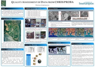
- 1. QUALITY ASSESSMENT OF DATA FROM CHRIS/PROBA POLINA LEMENKOVA INFO Student ID: 3 23369248. Course: ’GEOG6038 Calibration and Val- idation of Earth Observation Data’. Practical 1: Quality assessment of data from CHRIS/PROBA. Student: Lemenkova P. Supervisor: Prof. Dr. E. J. Milton. Funding: Erasmus Mundus MSc Scholarship GEM- L0022/2009/EW, University of Southampton, UK. 2009. Acknowledgement: I thank Brian Amberg and Thomas Vetter (Univeraität Basel) for baposter LATEX source code used for this poster. INTRODUCTION Image: Vertical air photo of Thorney Island. ROI: Thorney Island, Chichester harbour (UK): unique wetland environment, a place for rare bird colonies. Monitor- ing this place is important for environmental management. CHRIS/PROBA image characteristics: 18 bands, 07/10/2004, 17m ground resolution. DATA: CHRIS/PROBA IMAGE CHRIS (Compact High Resolution Imaging Spectrometer): new imaging spectrometer carried on board a space plat- form PROBA, http://www.chris-proba.org.uk/. More infor- mation: Cutter M.A., Lobb D.R. Cockshott R. (2000) Compact High Resolution Imaging Spectrometer. Elsevier Science Ltd, Kent, UK. Kuusk A., Kuusk J., Lang M.. A dataset for the vali- dation of reflectance models. Remote Sensing of Environment 113 (2009) 889–892 PROBA: Project for On Board Autonomy. The satellite was successfully launched in late Octo- ber 2001, Shriharikota (India). Info: Bermin J. PROBA – Project for On-Board Autonomy and web: http://earth.esa.int/missions/thirdpartymission/proba.html CHRIS IMAGE QUALITY For the quality of CHRIS images .hdr files were examined: 1. CHRIS...47AO_41.hdr (taken at +36◦) 2. CHRIS...47A1_41.hdr (taken at -36◦) 3. CHRIS...47A2_41.hdr (taken at +55◦) 4. CHRIS...47A3_41.hdr (taken at -55◦) 5. CHRIS...479F_41.hdr (taken at nadir) Images taken at the nadir are of good quality, while those at different angles have defects Left: Comparing images taken at +55◦dgr (47A2_41) and nadir images (479F_41) right Right: Images taken at +36◦dgr (47A0_41), left and nadir images (479F_41) right. CHRIS.hdrfiles Left: Inverted Image received from bands Combination 4(R)-2(G)-1(B). Right: Images taken at +36◦and -36◦(CHRIS 47A0_41 and CHRIS 47A1_41) both have inverted direction. SPECTRAL BANDS NarrowbandsNarrowbands IMAGE NOISE 2 types of noise affecting CHRIS images: 1. vertical noise (vertical stripes corrected by comparing values of neighbor pixels) 2. horizontal noise (easy to detect and correct using horizontal profile of each file Example of vertical noises in CHRIS image (left). Image source: Garcia J.G., Moreno J. Removal of noises in CHRIS/PROBA images: Applica- tion to the Sparc Campaign Data. Correction of noises can be made through DIELMO 3D Methodology. Example of horizontal noise in CHRIS image. CHRIS_CH_041007_479F_41 Bands_12-8-1 CHRIS_CH_041007_479F_41 Bands_7-4-1 CHRIS_CH_041007_479F_41 Bands_11-4-2 CHRIS_CH_041007_479F_41 Bands_6-5-2 CHRIS_CH_041007_479F_41 Bands_15-4-1 IMAGE INVERSION Inverted Image, bands: Left:13-12-11. Right: 9(R)-10(G)-11(B). ← Left: CHRIS Superspectral Land: Many narrow bands around the red-edge. Image source: Barnsley M.J. et al. The PROBA/CHRIS Mission: A Low-Cost Smallsat for Hyperspectral, Multi-Angle, Observations of the Earth Surface and Atmosphere. . ⇐Right: CHRIS Superspectral Water: many narrow bands in visible wavelengths. Figure contrasts per frame evidence for each patch with or w/o a background model. ←Quality natural-colored image of wetlands: nadir-taken CHRIS image with bands combination of corresponding spectral channels. View angles in a CHRIS/PROBA acquisition. BIBLIOGRAPHY Author’s publications on Geography, Remote Sensing and GIS: 1 P. Lemenkova, “Using ArcGIS in Teaching Geosciences”, Russian, B.Sc. Thesis (Lomonosov Moscow State University, Faculty of Edu- cational Studies, Moscow, Russia, June 5, 2007), 58 pp., https : / / thesiscommons.org/nmjgz. 2 P. Lemenkova, “Geoecological Mapping of the Barents and Pe- chora Seas”, Russian, B.Sc. Thesis (Lomonosov Moscow State Univer- sity, Faculty of Geography, Department of Cartography and Geoin- formatics, Moscow, Russia, May 18, 2004), 78 pp., https : / / thesiscommons.org/bvwcr. 3 P. Lemenkova, Ecological and Geographical Mapping of the Baltic Sea Region in the Gulf of Finland, Russian, Moscow, Russia: Lomonosov Moscow State University, Mar. 30, 2002, https://zenodo.org/ record/2574447, Term Paper. 4 H. W. Schenke and P. Lemenkova, “Zur Frage der Meeresboden- Kartographie: Die Nutzung von AutoTrace Digitizer für die Vek- torisierung der Bathymetrischen Daten in der Petschora-See”, Ger- man, Hydrographische Nachrichten 25, 16–21, ISSN: 0934-7747 (2008). 5 I. Suetova, L. Ushakova, and P. Lemenkova, “Geoinformation map- ping of the Barents and Pechora Seas”, Geography and Natural Re- sources 4, edited by V. A. Snytko, 138–142, ISSN: 1875-3728 (2005), http://www.izdatgeo.ru/journal.php?action=output& id=3&lang_num=2&id_dop=68.