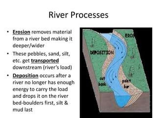
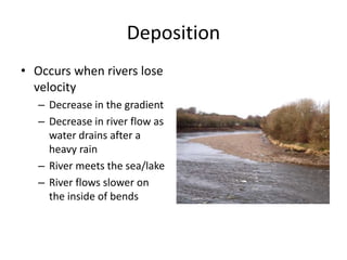
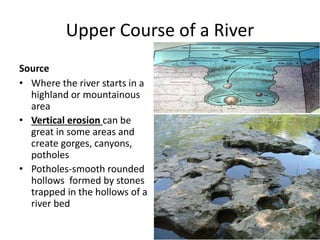
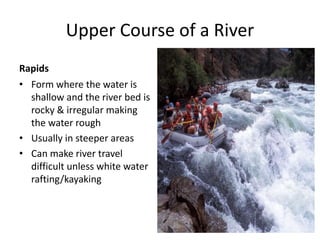
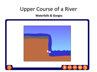
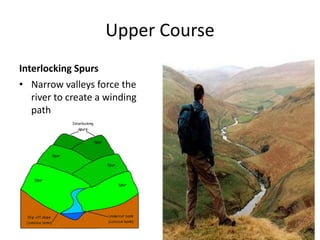
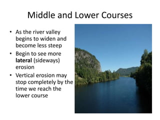
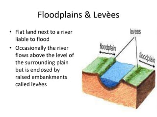
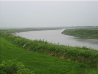
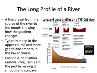
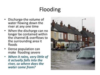
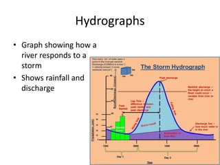
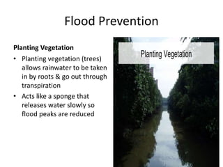
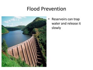
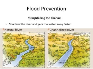
River Processes & Landforms
Chapter 5
River Processes
• Erosion removes material
from a river bed making it
deeper/wider
• These pebbles, sand, silt,
etc. get transported
downstream (river’s load)
• Deposition occurs after a
river no longer has enough
energy to carry the load
and drops it on the river
bed-boulders first, silt &
mud last
How a River Transports
WORKSHEET
Factors Affecting River Work
• Velocity/energy-the
faster the river the
larger the material able
to be transported
• After rain rivers may
look brown due to
suspension
Factors Affecting River Work
• Volume-the more water
the greater the volume
of the load
• Bedrock-harder rocks-
i.e. granite- erode
slowly, soft rocks-shale-
erode easily & some
rocks- i.e. limestone-
can be dissolved
completely
Deposition
• Occurs when rivers lose
velocity
– Decrease in the gradient
– Decrease in river flow as
water drains after a
heavy rain
– River meets the sea/lake
– River flows slower on
the inside of bends
The River Channel
Upper Course of a River
Source
• Where the river starts in a
highland or mountainous
area
• Vertical erosion can be
great in some areas and
create gorges, canyons,
potholes
• Potholes-smooth rounded
hollows formed by stones
trapped in the hollows of a
river bed
Upper Course of a River
Rapids
• Form where the water is
shallow and the river bed is
rocky & irregular making
the water rough
• Usually in steeper areas
• Can make river travel
difficult unless white water
rafting/kayaking
Upper Course of a River
Waterfalls & Gorges
Victoria Falls Zambia & Zimbabwe
HTTPS://WWW.YOUTUBE.COM/WA
TCH?V=YP1J1CSZACM
Waterfalls & Gorges
Positives
• Brings in tourists
• Hydroelectricity
Negatives
• Can cause navigation
problems, makes the river
difficult to cross
Upper Course
Interlocking Spurs
• Narrow valleys force the
river to create a winding
path
Middle and Lower Courses
• As the river valley
begins to widen and
become less steep
• Begin to see more
lateral (sideways)
erosion
• Vertical erosion may
stop completely by the
time we reach the
lower course
Meanders & Oxbows
Meanders & Oxbow Lakes
Floodplains & Levèes
• Flat land next to a river
liable to flood
• Occasionally the river
flows above the level of
the surrounding plain
but is enclosed by
raised embankments
called levèes
Floodplains & Levèes
Deltas
• Low-lying flat marshy
land where a river
meets a sea/lake
• Formed from a river
with carrying a lot of
sediments that meets a
still sea/lake and the
sediments build up
• May cause
distributaries
Mississippi Delta, USA
Mahakam River, Borneo
The Long Profile of a River
• A line drawn from the
source of the river to
the mouth showing
how the gradient
changes
• Typically steep in the
upper course and more
gentle and smooth in
the lower course
• Erosion & deposition
remove irregularities in
the profile making it
smooth and concave
Long Profile
ACTIVITY
Living in River Flood Plains & Deltas
• Often densely populated
• Offer flat land (easy to
build)
• Fertile soils
• River valleys are natural
route ways
• Navigable rivers allow
transport & trade
• Provide drinking water
and food source
Living in River Flood Plains & Deltas
• Tropics can suffer from diseases
carried by insects i.e. malaria
(mosquitoes) & sleeping
sickness (tsetse flies)
HTTPS://WWW.YOUTUBE.COM/WATCH
?V=4AVURGO97ZG
Flooding
• Discharge-the volume of
water flowing down the
river at any one time
• When the discharge can no
longer be contained within
the channel & overflows to
the surrounding area it
floods
• Dense population can
make flooding severe
• When it rains, very little of
it actually falls into the
river, so where does the
water come from?
Flooding
Activity
Factors Affecting Discharge
• Rainfall
• Relief
– Rainwater runs over steep slopes
vs. infiltration on gentle
• Land Use
• Weather Conditions
– Hi-temps reduce discharge
• Rock & Soil Type
– Permeable vs. impermeable
Hydrographs
• Graph showing how a
river responds to a
storm
• Shows rainfall and
discharge
Flood Prevention
Planting Vegetation
• Planting vegetation (trees)
allows rainwater to be taken
in by roots & go out through
transpiration
• Acts like a sponge that
releases water slowly so
flood peaks are reduced
Flood Prevention
• Reservoirs can trap
water and release it
slowly
Flood Prevention
Straightening the Channel
• Shortens the river and gets the water away faster.
Kissimmee River, Florida USA
Flood Prevention
Artificial Levèes
• Increase the capacity of the channel
• Usually banks are strengthened with concrete or stone so less
likely to break
Flood Prevention
Dredging the Channel
• By making it deeper this
increases the capacity and
makes it less likely to
overflow
Flood Prevention
Bridge Design
• Bridges with wide pillars and
walls on top act like dams which
hold back water; modern bridges
are slim and prevent this from
happening
Flood Prevention
Wash Lands
• Control land on flood plains
areas for recreation instead of
residential to minimize
damage
CAUSE & EFFECTS
Textbook Pg. 132-137 #7

River processes & landforms

  • 1.
    River Processes &Landforms Chapter 5
  • 2.
    River Processes • Erosionremoves material from a river bed making it deeper/wider • These pebbles, sand, silt, etc. get transported downstream (river’s load) • Deposition occurs after a river no longer has enough energy to carry the load and drops it on the river bed-boulders first, silt & mud last
  • 3.
    How a RiverTransports
  • 4.
  • 5.
    Factors Affecting RiverWork • Velocity/energy-the faster the river the larger the material able to be transported • After rain rivers may look brown due to suspension
  • 6.
    Factors Affecting RiverWork • Volume-the more water the greater the volume of the load • Bedrock-harder rocks- i.e. granite- erode slowly, soft rocks-shale- erode easily & some rocks- i.e. limestone- can be dissolved completely
  • 7.
    Deposition • Occurs whenrivers lose velocity – Decrease in the gradient – Decrease in river flow as water drains after a heavy rain – River meets the sea/lake – River flows slower on the inside of bends
  • 8.
  • 9.
    Upper Course ofa River Source • Where the river starts in a highland or mountainous area • Vertical erosion can be great in some areas and create gorges, canyons, potholes • Potholes-smooth rounded hollows formed by stones trapped in the hollows of a river bed
  • 10.
    Upper Course ofa River Rapids • Form where the water is shallow and the river bed is rocky & irregular making the water rough • Usually in steeper areas • Can make river travel difficult unless white water rafting/kayaking
  • 11.
    Upper Course ofa River Waterfalls & Gorges
  • 12.
  • 13.
  • 14.
    Waterfalls & Gorges Positives •Brings in tourists • Hydroelectricity Negatives • Can cause navigation problems, makes the river difficult to cross
  • 15.
    Upper Course Interlocking Spurs •Narrow valleys force the river to create a winding path
  • 16.
    Middle and LowerCourses • As the river valley begins to widen and become less steep • Begin to see more lateral (sideways) erosion • Vertical erosion may stop completely by the time we reach the lower course
  • 17.
  • 18.
  • 19.
    Floodplains & Levèes •Flat land next to a river liable to flood • Occasionally the river flows above the level of the surrounding plain but is enclosed by raised embankments called levèes
  • 20.
  • 22.
    Deltas • Low-lying flatmarshy land where a river meets a sea/lake • Formed from a river with carrying a lot of sediments that meets a still sea/lake and the sediments build up • May cause distributaries
  • 23.
  • 24.
  • 25.
    The Long Profileof a River • A line drawn from the source of the river to the mouth showing how the gradient changes • Typically steep in the upper course and more gentle and smooth in the lower course • Erosion & deposition remove irregularities in the profile making it smooth and concave
  • 26.
  • 27.
  • 28.
    Living in RiverFlood Plains & Deltas • Often densely populated • Offer flat land (easy to build) • Fertile soils • River valleys are natural route ways • Navigable rivers allow transport & trade • Provide drinking water and food source
  • 29.
    Living in RiverFlood Plains & Deltas • Tropics can suffer from diseases carried by insects i.e. malaria (mosquitoes) & sleeping sickness (tsetse flies)
  • 31.
  • 32.
    Flooding • Discharge-the volumeof water flowing down the river at any one time • When the discharge can no longer be contained within the channel & overflows to the surrounding area it floods • Dense population can make flooding severe • When it rains, very little of it actually falls into the river, so where does the water come from?
  • 33.
  • 34.
  • 35.
    Factors Affecting Discharge •Rainfall • Relief – Rainwater runs over steep slopes vs. infiltration on gentle • Land Use • Weather Conditions – Hi-temps reduce discharge • Rock & Soil Type – Permeable vs. impermeable
  • 37.
    Hydrographs • Graph showinghow a river responds to a storm • Shows rainfall and discharge
  • 38.
    Flood Prevention Planting Vegetation •Planting vegetation (trees) allows rainwater to be taken in by roots & go out through transpiration • Acts like a sponge that releases water slowly so flood peaks are reduced
  • 39.
    Flood Prevention • Reservoirscan trap water and release it slowly
  • 40.
    Flood Prevention Straightening theChannel • Shortens the river and gets the water away faster.
  • 41.
  • 42.
    Flood Prevention Artificial Levèes •Increase the capacity of the channel • Usually banks are strengthened with concrete or stone so less likely to break
  • 44.
    Flood Prevention Dredging theChannel • By making it deeper this increases the capacity and makes it less likely to overflow
  • 45.
    Flood Prevention Bridge Design •Bridges with wide pillars and walls on top act like dams which hold back water; modern bridges are slim and prevent this from happening
  • 46.
    Flood Prevention Wash Lands •Control land on flood plains areas for recreation instead of residential to minimize damage
  • 47.
  • 48.