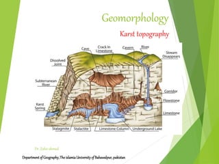
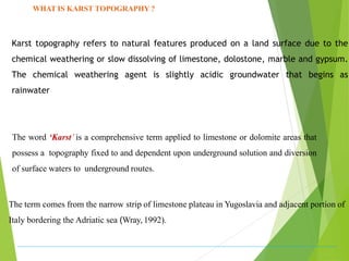
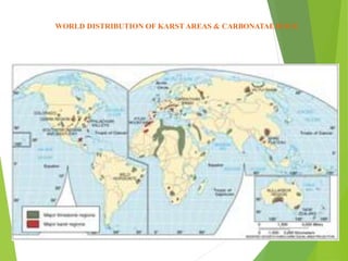
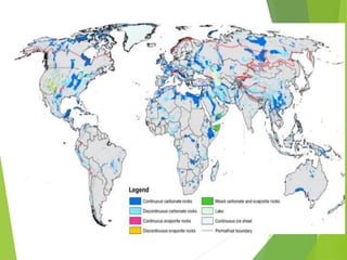
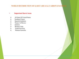
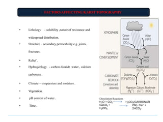
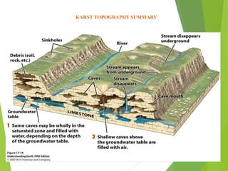
Geomorphology
Departmentof Geography,TheislamiaUniversityof Bahawalpur,pakistan
Dr. Zahir ahmad
Karst topography
WHAT IS KARST TOPOGRAPHY ?
The word ‘Karst’ is a comprehensive term applied to limestone or dolomite areas that
possess a topography fixed to and dependent upon underground solution and diversion
of surface waters to underground routes.
The term comes from the narrow strip of limestone plateau in Yugoslavia and adjacent portion of
Italy bordering the Adriatic sea (Wray, 1992).
Karst topography refers to natural features produced on a land surface due to the
chemical weathering or slow dissolving of limestone, dolostone, marble and gypsum.
The chemical weathering agent is slightly acidic groundwater that begins as
rainwater
 The origin of karst topography being carved by groundwater was
based on the Dinaric Kras region
 It was first described in literature by the Serbian geographer Jovan
Cvijic in his publication "Das Karstphänomen" (1893).
WORLD DISTRIBUTION OF KARST AREAS & CARBONATAEROCK
• Important Karst Areas
 All State Of United States
 Southern France
 SpanishAndularia
 Yuctan In Mexico
 Jamaica
 Western Cuba
 South EastAsia
 WesternAustralia
CONDITIONS ESSENTIALTO FULLDEVELOPMENT OF KARST
• Presence of soluble rock preferably limestone at or near the ground surface.
• The soluble rock should be massive, dense, highly jointed and preferably thinlybedded.
• Existence of entrenched valley below uplands underlain by soluble and well jointedrocks.
• The region must support moderate to abundant rainfall.
• The position of soluble rock(limestone) must be above the ground water table, so that surface
drainage may disappear through sink.
• Considerable relief so that water is capable of circulation to cause typical karst topography.
FACTORSAFFECTING KARSTTOPOGRAPHY
• Lithology – solubility ,nature of resistance and
widespread distribution.
• Structure – secondary permeability e.g. joints ,
fractures.
• Relief .
• Hydrogeology - carbon dioxide ,water , calcium
carbonate .
• Climate – temperature and moisture .
• Vegetation .
• pH content of water .
• Time .
Dissolution Reactions
H2O + CO2
CaCO3 +
H2CO3
H2CO3(CARBONATI
ON) Ca2+ +
2HCO3
–
EROSIONAL LANDFORMS OF KARST
1) Terra Rossa - Red clayey soil found along
joint ( moderate slope).
2) Lapies: Small solution furrows with pitted &
rugged surface (horizontal surface). Depth- 1 cm to 1
m.
EROSIONAL LANDFORMS OFKARST
depressions, funnel
3 Sinkholes - Shallow
shaped, 10 feet – 30 feet.
4 Dolines – circular solution depressions, formed
along intersection joints (solution sinks) .
5 Solution pan – large width but shallow dolines.
EROSIONAL LANDFORMS OFKARST
• 6) Swallow Holes :
• Surface opening through which water
enters a sinkholes.
7) Uvalas
• Large depressions due to
merging of sinkholes, have irregular floor.
EROSIONAL LANDFORMS OFKARST
8) Polje – Elongated basin, flat floor with
alluvium, steep enclosing walls,
9) Cave & Caverns – Natural subterranean runway
voids, large dimension voids below ground surface
formed by solution activity and abrasion along
jointing plains.
EROSIONAL LANDFORMS OFKARST
10 Natural bridge – collapse of roof ofcaves.
- disappearance of surface
streams as subterranean streams and
reappearance of subterranean stream on the
ground surface.
DEPOSITIONALLANDFORMS
Stalactites &Stalagmites
Column
Soda straw
Helictites & Heligmites
KARST CYCLE OFEROSION
•
• It is a special phase of normal fluvial cycle (Davis,
1930).
Three stages
1. Youth stage – The enlargement of sink holes and swallow
holes into dolines surface drainage starts disappearing
underground through different sinks or blind valleys.
Features are sinkholes, swallow holes, dolines, lapies,
blind valleys, sinking creeks, caves and caverns of smaller
dimension.
2. Mature stage - Total disappearance of surface drainage
underground. The surface drainage disappears
underground through dolines and blind valleys.
3. Old stage - The cave roofs are totally collapsed and ridges
with pitted surface between uvalas are considerably
narrowed down and reduced in height.
WHY KARST IS IMPORTANT?
• Geotechnical studies – construction of towns,
roadways, railways, bridges, buildings etc.
• Water movements studies – underground drainage
systems, drinking water springs.
• Paleoclimatic studies – karst topography reflects
a particular settings of climatic conditions
mention earlier.
• Recreational activities - Although most of the
caves located in National Parks are protected,
there are over 200 commercial show caves
nationwide which are open to the public.
KARST TOPOGRAPHY SUMMARY

Karst Topography.pptx

  • 1.
  • 2.
    WHAT IS KARSTTOPOGRAPHY ? The word ‘Karst’ is a comprehensive term applied to limestone or dolomite areas that possess a topography fixed to and dependent upon underground solution and diversion of surface waters to underground routes. The term comes from the narrow strip of limestone plateau in Yugoslavia and adjacent portion of Italy bordering the Adriatic sea (Wray, 1992). Karst topography refers to natural features produced on a land surface due to the chemical weathering or slow dissolving of limestone, dolostone, marble and gypsum. The chemical weathering agent is slightly acidic groundwater that begins as rainwater
  • 3.
     The originof karst topography being carved by groundwater was based on the Dinaric Kras region  It was first described in literature by the Serbian geographer Jovan Cvijic in his publication "Das Karstphänomen" (1893).
  • 4.
    WORLD DISTRIBUTION OFKARST AREAS & CARBONATAEROCK
  • 6.
    WORLD DISTRIBUTION OFKARST AREAS & CARBONATAEROCK • Important Karst Areas  All State Of United States  Southern France  SpanishAndularia  Yuctan In Mexico  Jamaica  Western Cuba  South EastAsia  WesternAustralia
  • 7.
    CONDITIONS ESSENTIALTO FULLDEVELOPMENTOF KARST • Presence of soluble rock preferably limestone at or near the ground surface. • The soluble rock should be massive, dense, highly jointed and preferably thinlybedded. • Existence of entrenched valley below uplands underlain by soluble and well jointedrocks. • The region must support moderate to abundant rainfall. • The position of soluble rock(limestone) must be above the ground water table, so that surface drainage may disappear through sink. • Considerable relief so that water is capable of circulation to cause typical karst topography.
  • 8.
    FACTORSAFFECTING KARSTTOPOGRAPHY • Lithology– solubility ,nature of resistance and widespread distribution. • Structure – secondary permeability e.g. joints , fractures. • Relief . • Hydrogeology - carbon dioxide ,water , calcium carbonate . • Climate – temperature and moisture . • Vegetation . • pH content of water . • Time . Dissolution Reactions H2O + CO2 CaCO3 + H2CO3 H2CO3(CARBONATI ON) Ca2+ + 2HCO3 –
  • 9.
    EROSIONAL LANDFORMS OFKARST 1) Terra Rossa - Red clayey soil found along joint ( moderate slope). 2) Lapies: Small solution furrows with pitted & rugged surface (horizontal surface). Depth- 1 cm to 1 m.
  • 10.
    EROSIONAL LANDFORMS OFKARST depressions,funnel 3 Sinkholes - Shallow shaped, 10 feet – 30 feet. 4 Dolines – circular solution depressions, formed along intersection joints (solution sinks) . 5 Solution pan – large width but shallow dolines.
  • 11.
    EROSIONAL LANDFORMS OFKARST •6) Swallow Holes : • Surface opening through which water enters a sinkholes. 7) Uvalas • Large depressions due to merging of sinkholes, have irregular floor.
  • 12.
    EROSIONAL LANDFORMS OFKARST 8)Polje – Elongated basin, flat floor with alluvium, steep enclosing walls, 9) Cave & Caverns – Natural subterranean runway voids, large dimension voids below ground surface formed by solution activity and abrasion along jointing plains.
  • 13.
    EROSIONAL LANDFORMS OFKARST 10Natural bridge – collapse of roof ofcaves. - disappearance of surface streams as subterranean streams and reappearance of subterranean stream on the ground surface.
  • 14.
  • 15.
    KARST CYCLE OFEROSION • •It is a special phase of normal fluvial cycle (Davis, 1930). Three stages 1. Youth stage – The enlargement of sink holes and swallow holes into dolines surface drainage starts disappearing underground through different sinks or blind valleys. Features are sinkholes, swallow holes, dolines, lapies, blind valleys, sinking creeks, caves and caverns of smaller dimension. 2. Mature stage - Total disappearance of surface drainage underground. The surface drainage disappears underground through dolines and blind valleys. 3. Old stage - The cave roofs are totally collapsed and ridges with pitted surface between uvalas are considerably narrowed down and reduced in height.
  • 16.
    WHY KARST ISIMPORTANT? • Geotechnical studies – construction of towns, roadways, railways, bridges, buildings etc. • Water movements studies – underground drainage systems, drinking water springs. • Paleoclimatic studies – karst topography reflects a particular settings of climatic conditions mention earlier. • Recreational activities - Although most of the caves located in National Parks are protected, there are over 200 commercial show caves nationwide which are open to the public.
  • 17.