NO1 Pakistan online istikhara for love marriage vashikaran specialist love pr...
07Aboveground_Carbon_Stock.pdf
1. Aboveground Carbon Stock
Aboveground carbon refers to the carbon biomass of living vegetation, both woody and herbaceous, above the
soil including stems, stumps, branches, bark, seeds, and foliage. IPCC’s Guidelines for National Greenhouse
Gas Inventories for agriculture, forestry, and other land use (Tier 1 data): defines aboveground biomass as “all
biomass of living vegetation, both woody and herbaceous, above the soil including stems, stumps, branches,
bark, seeds, and foliage”. Biomass can be converted to carbon using a factor of 0.46, and from carbon to carbon
dioxide equivalent (CO2e) using the factor of 3.67. Carbon stocks are relevant for quantifying terrestrial carbon
storage and carbon sinks as well as for estimating potential emissions and removals from land cover changes
(deforestation, reforestation, afforestation, agriculture) and from biotic (pests, diseases) and abiotic (e.g., forest
fires, windstorms) disturbances.
Methodology
A good but very general source of data for carbon storage is the Intergovernmental Panel on Climate Change’s
(IPCC) 2006 methodology for determining greenhouse gas inventories in the Agriculture, Forestry and Other
Land Use (AFOLU) sector. To use this set of information from the IPCC, the site’s climate domain and region
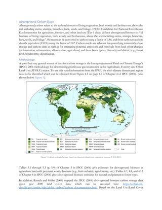
need to be identified which can be obtained from Figure 4.1 on page 4.9 of Chapter 4 of IPCC (2006). (also
shown below Figure 3).
Figure 1: Global ecological zones, based on observed climate and vegetation patterns (FAO, 2001)
Tables 5.1 through 5.3 (p. 5.9) of Chapter 5 in IPCC (2006) give estimates for aboveground biomass in
agriculture land with perennial woody biomass (e.g., fruit orchards, agroforestry, etc.). Tables 4.7, 4.8, and 4.12
of Chapter 4 in IPCC (2006) gives aboveground biomass estimates for natural and plantation forest types.
In addition, Ruesch and Gibbs (2008) mapped the IPCC (2006) aboveground biomass carbon storage data
given year 2000 land cover data, which can be accessed here: https://cdiac.ess-
dive.lbl.gov/epubs/ndp/global_carbon/carbon_documentation.html. Based on the Land Use/Land Cover
2. classes present on different FAO ecoregions zones, the aboveground carbon values are assigned from the look
up table available in the above-mentioned website. For this purpose, any GIS software such as QGIS or ArcGIS
can be used.
The input data for estimating aboveground carbon is shown in Table 21.
Table 1: Input data for estimating aboveground carbon
Variable Sensor/Dataset Spatial resolution Extent
Land cover ESA CCI 300 m Global
Besides, there is a global dataset of 300 m spatial resolution from Spawn and Gibbs (2020) which shows global
aboveground and belowground biomass carbon density maps for the year 2010 and can be accessed from
https://daac.ornl.gov/VEGETATION/guides/Global_Maps_C_Density_2010.html.