TEST BANK For Geosystems An Introduction to Physical Geography, 5th Canadian ...
08Belowground_Carbon_Stock.pdf
1. Belowground Carbon Stock
Belowground carbon refers to carbon biomass of living root systems. It is usually estimated using a below-
aboveground biomass ratio. IPCC’s Guidelines for National Greenhouse Gas Inventories for agriculture,
forestry, and other land use (Tier 1 data): define belowground biomass as “all biomass of live roots. Fine roots
of less than (suggested) 2 mm diameter is often excluded because these often cannot be distinguished
empirically from soil organic matter or litter.” Biomass can be converted to carbon using a factor of 0.46, and
from carbon to carbon dioxide equivalent (CO2e) using the factor of 3.67.
Aboveground carbon inputs in the soil can easily be measured with standard approaches. On the other hand,
belowground carbon inputs can be defined as root mortality occurring over a specified period of time, plus all
carbon allocated below-ground by plants to root-associated organisms such as mycorrhizae, or rhizo-deposits
(Berhongaray et al., 2019). The quantification of this belowground carbon input is complex, but important as
e.g. the inputs via mycorrhizae can exceed the input via leaf litter and fine root turnover (Godbold et al. 2006).
Methodology
For LULC categories dominated by woody biomass, belowground biomass can be estimated roughly with the
“root to shoot” ratio of belowground to aboveground biomass. Default estimates of the root to shoot ratio are
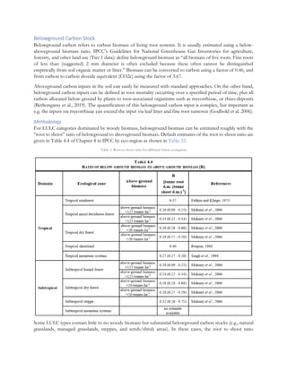
given in Table 4.4 of Chapter 4 in IPCC by eco-region as shown in Table 22.
Table 1: Root-to-shoot ratio for different forest ecoregions
Some LULC types contain little to no woody biomass but substantial belowground carbon stocks (e.g., natural
grasslands, managed grasslands, steppes, and scrub/shrub areas). In these cases, the root to shoot ratio
2. described above does not apply and considered similar C values. Belowground estimates for these LULC types
are best estimated locally, but if local data are not available some global estimates can be used. The Chapter 6
of IPCC (2006) lists total biomass (aboveground plus belowground) and aboveground biomass for each climate
zone in table 6.4. The difference between these numbers is a crude estimate of belowground biomass. Based
on the Land Use/Land Cover classes present on different FAO ecoregions zones, the aboveground carbon
values are assigned from the look up table available in the above-mentioned website. For this purpose, any GIS
software such as QGIS or ArcGIS can be used.
The input data for estimating belowground carbon is shown in Table 23.
Table 2: Input data table for estimating belowground carbon
Variable Sensor/Dataset Spatial resolution Extent
Land cover ESA CCI 300 m Global
Besides, there is a global dataset of 300 m spatial resolution from Spawn and Gibbs (2020) which shows global
aboveground and belowground biomass carbon density maps for the year 2010 and can be accessed from
https://daac.ornl.gov/VEGETATION/guides/Global_Maps_C_Density_2010.html.