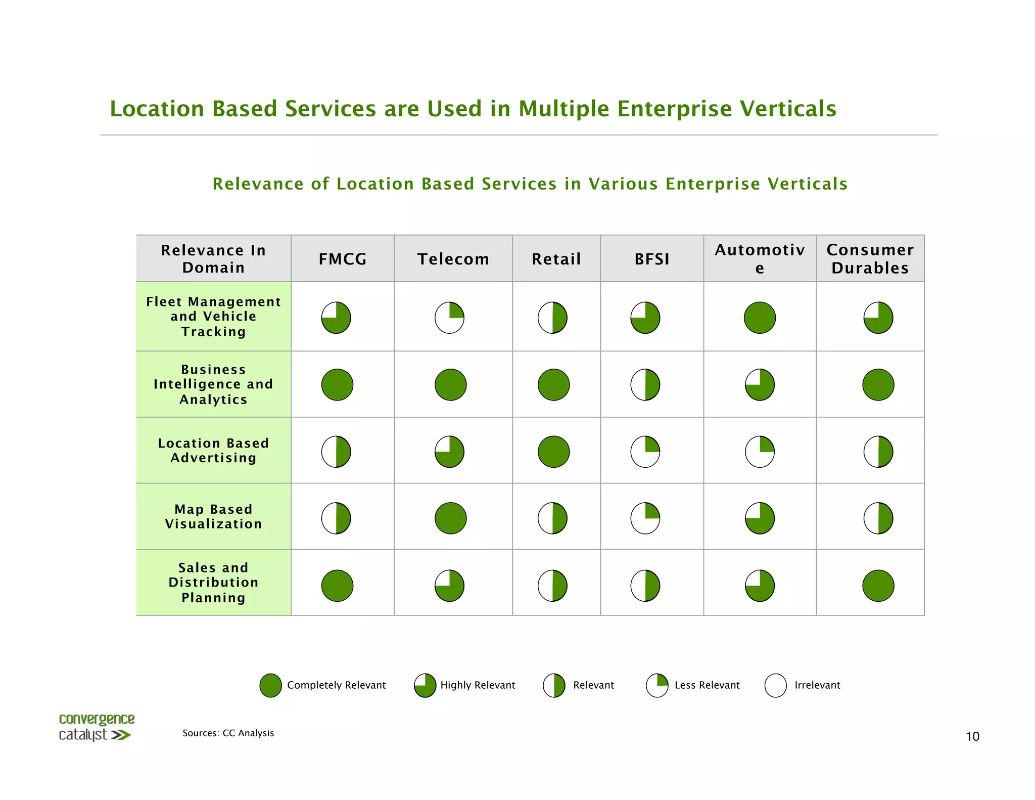
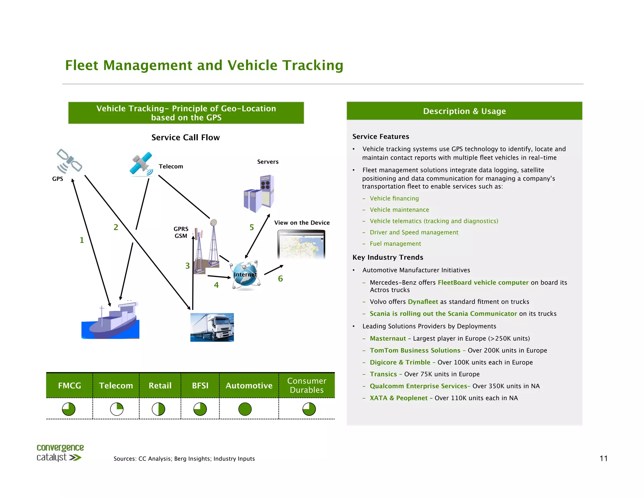
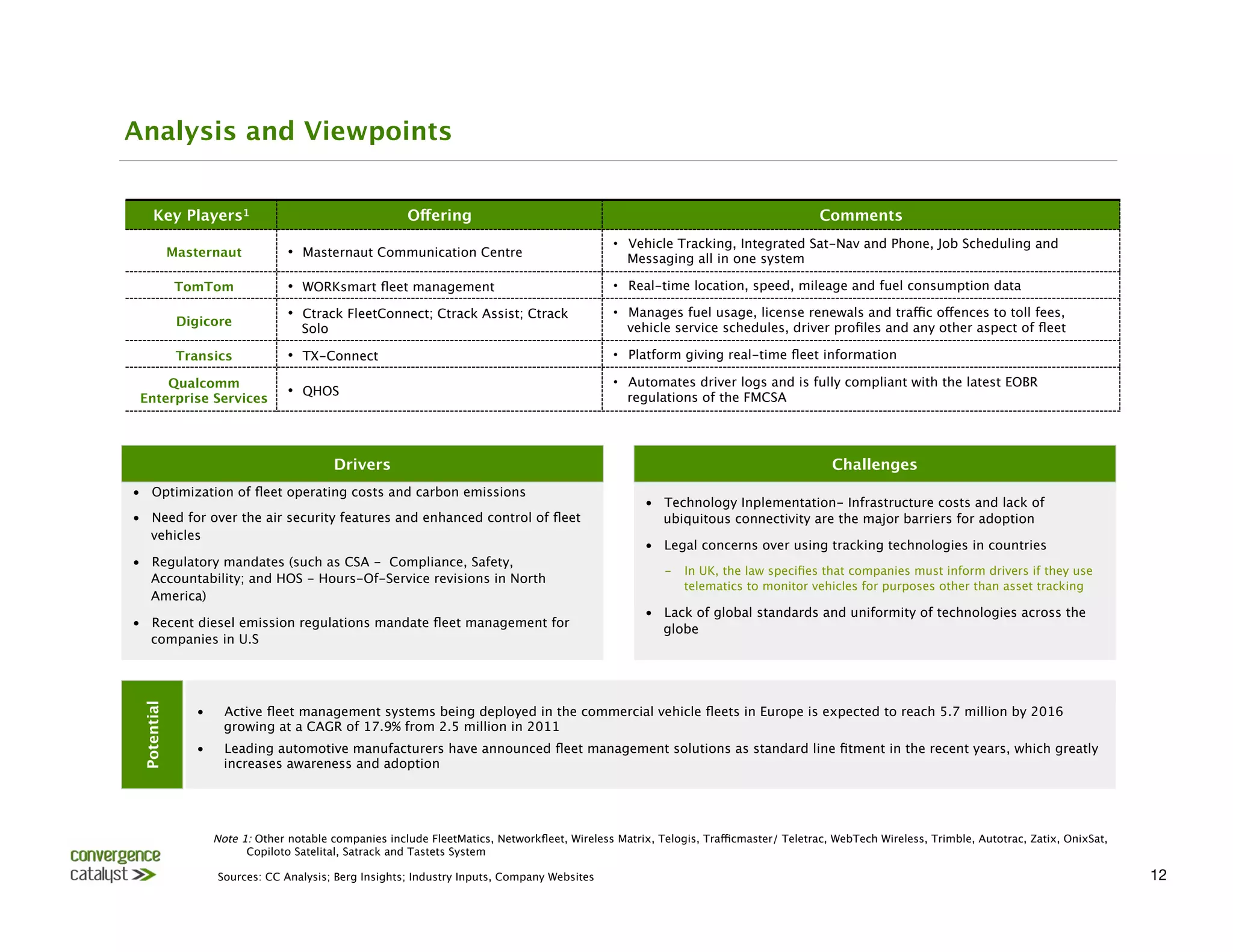
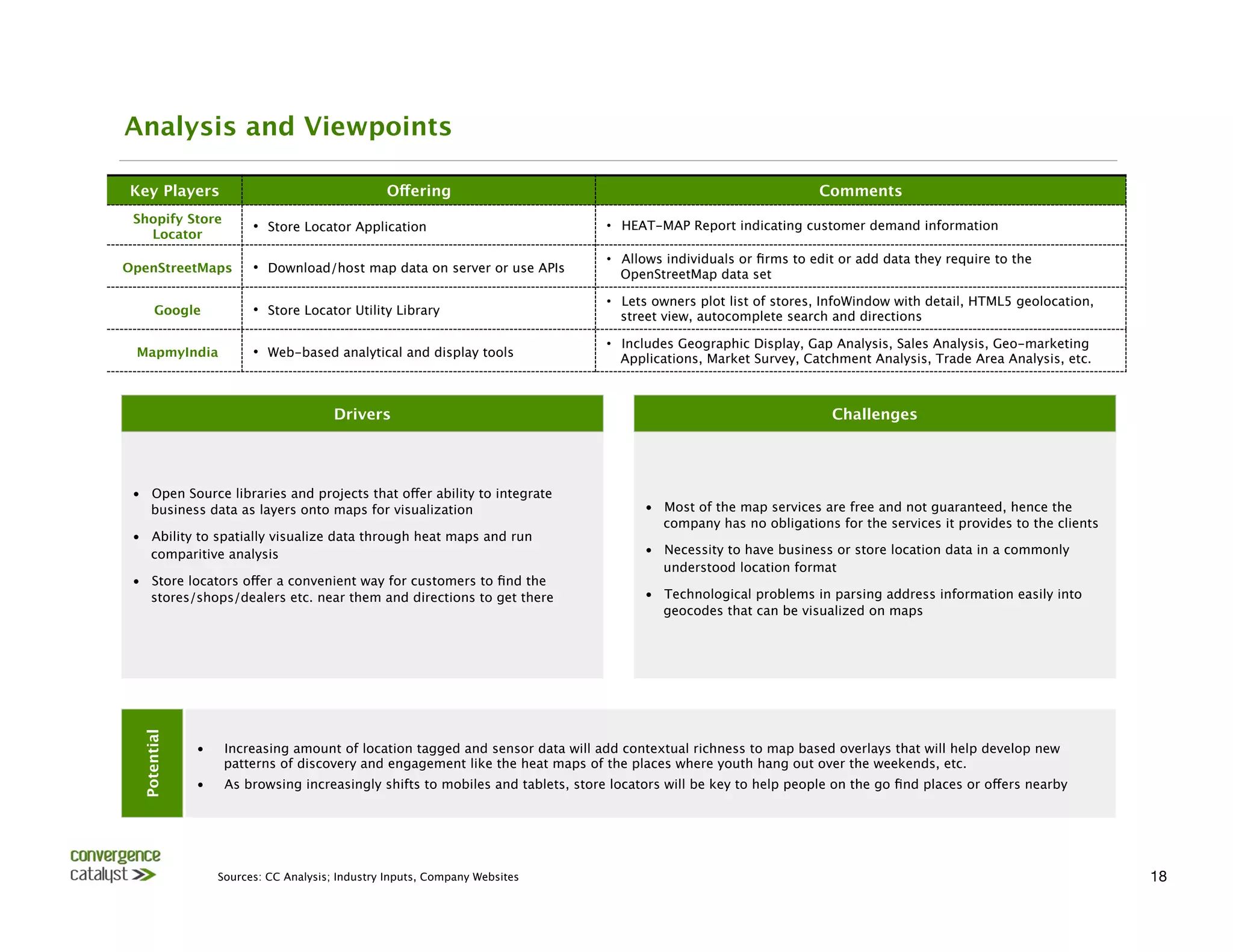
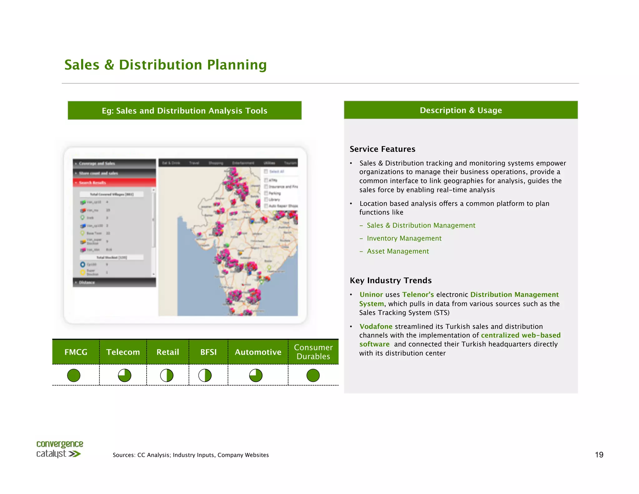
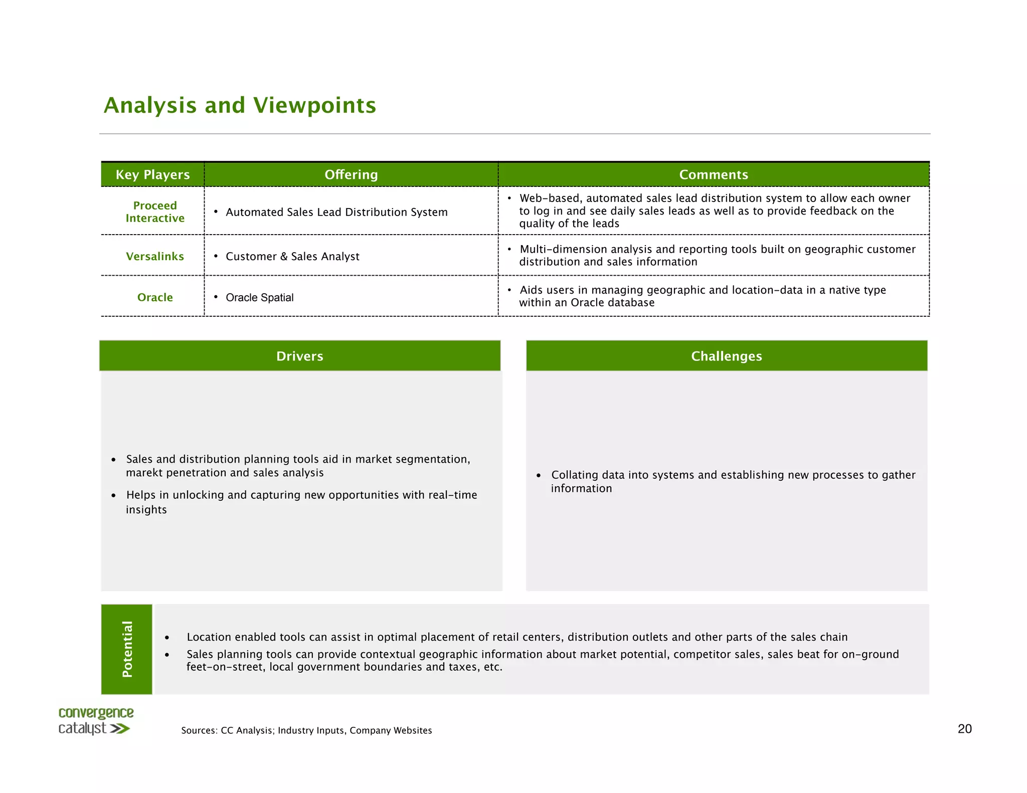
Overview of Various Location Based Services,

Deployment & Adoption Trends Around the World 


                      April 2013
                           
                          
        Shrinath V, Yagna Teja & Jayanth Kolla
Preface
Mention location based services (LBS), and most people think of maps and check-ins. Location based services (and the
allied geo-spatial services) have a potential and scope much wider in fields ranging from urban governance, fleet
management, data analytics and local exploration.

Though many of the previous years have been heralded as the time ripe for LBS, it is only recently that many pieces of
the puzzle are falling into place. At one hand, GPS enabled smartphones are commonplace, generating a wealth of
location info. On the other hand, governments have recognized the benefits that geo-spatial services can bring to
governance. The enterprise segment is exploring the potential of location based analytics and location based
advertising, amongst others. 

With global interest in the potential of LBS, newer business applications are evolving for various domains. However, in
our opinion, there is a lack of awareness of what LBS can bring to the table and how it can be applied. This is one of the
key factors constraining the growth of the industry. 

Key thinking behind the report: We realized that there is no clear reference point for what location based services can
offer, growth drivers, barriers to adoption and what others have implemented and/or are experimenting with?

This report aims to highlight key services, categorized by their applicability to the enterprise, government and
consumer domains. This is not an exhaustive report of all services; rather, we have picked services that are indicative
of what benefits location can bring to existing solutions. As the intention is to highlight a variety of existing services,
we have intentionally omitted some newer advances in the domains such as indoor positioning, NFC based
applications, etc. 

About Convergence Catalyst: Convergence Catalyst is a young and nimble Telecom Research and Advisory firm
focusing on the Indian market. Convergence Catalyst (CC) principals bring decades of relevant Telecom experience in
the Indian Telecom and LBS Industry. Having been Technocrats, Product Marketers, Analysts and Business Consultants,
they bring a keen insights into emerging market dynamics. 

For this report, Convergence Catalyst has collaborated with Shrinath V, who in his last role, led the global product
management for location based services for Nokia’s Asha range of phones. Shrinath has a long history of on-ground
and strategic experience in the location based services and mobility domains having worked with many global industry
leaders in this space over the last decade.
Contents


  Overview of Location Based Services

  Location Based Services in Enterprise Segment

  Location Based Services in Government Sectors

  Location Based Services for Consumer Adoption

  Author Profiles and Convergence Catalyst Credentials
Introduction to Location Based Services                                                     


   LBS1 - Convergence of multiple technologies


                                                                                              •  Location based services (LBS) are a part of geo-
                                Web
                                GIS
                                                             spatial or geo-information systems that rely on a
          Internet
                                 GIS
                                                                                                   mapping representation, positioning information
                                                                                                   (through GPS, cell-tower, WiFi, etc.) and content or
                                 LBS
                                                                                                   service providers who can customize or enhance
                                                                                                   their offering ((eg: find nearest shop, share one’s
                Mobile 
                     Mobile 
               Internet
                      GIS
                                                 location, see nearest deals, etc.)
                                                                                              •  The geo-spatial industry in India was estimated to
                           Mobile Devices
                                                         a $3 billion business in 2011 employing over 135K
                                                                                                   people in a BCG report prepared for Google
                                                                                              •  LBS have a wide array of applications for
                                                                                                   individuals, enterprises and government services:
                                                                                                   mapping, navigation, local search, business
Location based services cover a wide range of services                                             intelligence and analytics, fleet and vehicle
 that are directly dependent on maps and navigation,                                               tracking, emergency and disaster management
   or have indirect applications like adding location
          information to photos, tweets, etc. 
                                                    solutions, etc.


                Note 1: Location Based Services (LBS) are a part of the larger umbrella of Geo-Spatial Services. For the purposes of this report, we these terms
                         synonymously
              Source: CC Analysis, Industry Inputs, BCG report for Google mapping services
                                                                        4
Location Based Services – Market Size and Growth Drivers 

          Global LBS – Market Size ($Billion)
                                                                 LBS Market Size (By Geography)

                                                             10.3


                                                                                                                 Americas, 51.0%
          Europe, 17.7%


                               4.4
                                                                                                 Asia Pacific,
                                                                                                                                       25.0%

   2.8
                                                                                                               MENA, 6.3%


  2010
                       2012
                          2015


•  Factors driving the growth of location based services include: 
  ­  Availability of cheaper GPS enabled devices 
  ­  High interest in personalizing services based on users’ location information and history 
  ­  Advancements in analysis capabilities
  ­  Evolving business models like mobile advertising, global deployments of 3G and 4G wireless services promising ubiquitous connectivity
  ­  Cost benefits by deploying solutions like vehicle tracking and fleet management
  ­  Government regulations regarding use of data


               Sources: CC Analysis & Estimates, Pyramid Research, Vision Gain, Gartner, McKinsey Global Institute, eMarketer 
                             5
Strong revenue growth expected over the next few years


     Global LBS Revenue by Region (USD, Billion)


9


                                                                                            •  Much of the growth in LBS is expected to come from
                                                                                              the countries in the Asia Pacific regions, especially
6
                                                                                              India & China, largely due to estimated growth in
                                                                                              wireless consumers to 2 billion users by 2017

                                                                                            •  LBS Revenues for the regions of Latin America,
                                                                                              Eastern Europe and the Africa & Middle East regions
                                                                                              are also expected to grow but at a lower rate than
3
                                                                                              North America, Western Europe & the Asia Pacific
                                                                                              regions


0
2011
        2012
        2013
          2014
          2015
         2016
         2017

     North America
               Latin America 
                Western Europe
     Eastern Europe
              Asia Pacific
                   Middle East & Africa


                 Sources: CC Analysis; TCS LBS White Paper; Industry Inputs
                                                                         6
Location Based Services – Overview of Key Services

                                Category
              Key Examples
                                                    Comments

                              Mapping,                                          •  M a ny c o nsume r se r vi c e s o ffe r so me
                                                    Find places or friends
                                                                                   c us t o mi z a t i o n b a s e d o n c ur r e nt l o c a t i o n, p l a c e
                            discovery and             nearby, maps, add
                                                                                   o r fr i e nd find e r s, ma p p i ng & a l l i e d func t i o ns l i k e
                            infotainment
           location to posts, etc.
       na vi ga ti o n, tr a ffic , e tc . 


                                                                                •  R e so ur c e t r a c k i ng wi t h d y na mi c d i st r i b ut i o n,
                                                   Vehicle & Fleet, Supply
                                Tracking
            Chain & Inventory
                                                                                   t a x i s , r e n t a l e q u i p m e n t , fl e e t s c h e d u l i n g, R F
                                                                                   T r a c k i ng e t c 


                                                                                •  Pinp o ints c o nsumer s lo c a tio n a nd p r o vid es
                                                    Mobile coupons, ads,
                              Advertising
           deal finders, etc.
                                                                                   l o c a t i o n-s p e c i fic a d s o n t he i r mo b i l e d e vi c e s o r
                                                                                   use s l o c a ti o n fo r a d r e ta r ge tti ng


  LBS
Services
                  Location based                                       •  A new range of location and AR services includ e
                              Games &                Real life games like
                                                                                   o ve r l a y i ng d i gi t a l i nfo o n p hy si c a l o b j e c t s fo r
                                                    Google Ingress, apps
                             Augmented             eg:Layar, City Lens, etc.
                                                                                   d i sc o ve r y o r ga mi ng, p o we r i ng we a r a b l e
                                                                                   c o mp ut i ng, e t c . 
                               Reality


                              Emergency                                         •  L o c a t i o n he l p s p l a nni ng ur b a n fa c i l i t i e s a nd
                             support and           Emergency 911, disaster         e l e me nt s l i k e l o c a t i ng e me r ge nc y s e r vi c e s ,
                               disaster             recovery services, etc.
       d i r e c t i ng he l p d ur i ng e me r ge nc i e s a nd d i sa st e r s,
                                                                                   etc.
                             management

                                                                                •  T r a d i t i o na l B I t o o l s a r e a d d i ng l o c a t i o n e l e me nt s
                                                    Business intelligence          t o o ff e r p r e c i s e ge o - a n a l y s i s . O t h e r b u s i n e s s u s e
                                Analytics 
        solutions, sales & dist.        c a s e s i nc l ud e s t o r e a nd c a t c hme nt a r e a p l a nni ng,
                                                        tracking, etc.
            d r i ve t i me a na l y si s, sa l e s c o mp a r i so n a c r o ss
                                                                                   areas, etc.


            Source: CC Analysis, Industry Inputs
Key Consumer Use Cases for LBS

N.A - Family Trackers, 
                                        EU – Mapping & Navigation
                              APAC – Restaurant Finders
Mapping & Navigation


                                                                     MENA – Navigation, Safety, 
 L.A - Friend Finders
                                                                      Emergency & Tracking


 •  Main consumer use cases for LBS globally include applications related to travel and socializing: GPS navigation, weather alerts, traffic updates,
    restaurant reviews and locating nearby businesses 
 •  Navigation is the most popular application used by 46% of all LBS users. Friend Finders constitute 22% of LBS app use cases. 26% use LBS to
    find restaurants and entertainment venues, 19% for public transport schedules and12.5% for deals and offers
 •  Friend Finders and location sharing are popular in Latin America, with 39% stating it as the top reason to use LBS, compared to 20% in Europe,
    11% in India and 9% in North America in a survey conducted by TNS, Mobile Life in 2012 
 •  In the technology-saturated markets of developed Asia, 36% of people use LBS to find restaurants and entertainment venues nearby,
    whereas in China this falls to 17%, and sub-Saharan Africa, at 10%


               Source: CC Analysis, Industry Inputs, TNS-Mobile Life 
                                                                                  8
Contents


  Overview of Location Based Services

  Location Based Services in Enterprise Segment

        Relevance of LBS in Enterprise Verticals         10

        Fleet Management & Vehicle Tracking 
        11

        Business Intelligence and Analytics              13

        Location Based Advertising                   15

        Map Based Visualization                          17

        Sales and Distribution Planning                  19


  Location Based Services in Government Sectors

  Location Based Services for Consumer Adoption

  Author Profiles and Convergence Catalyst Credentials
Location Based Services are Used in Multiple Enterprise Verticals


             Relevance of Location Based Services in Various Enterprise Verticals


    Relevance In                                                                                        Automotiv       Consumer
                                     FMCG
            Telecom
             Retail
          BFSI
      Domain
                                                                                               e
          Durables

   Fleet Management
      and Vehicle
        Tracking

       Business
   Intelligence and
       Analytics


    Location Based
     Advertising


      Map Based
     Visualization


      Sales and
     Distribution
      Planning


                               Completely Relevant
     Highly Relevant
        Relevant
       Less Relevant
   Irrelevant


       Sources: CC Analysis
                                                                                                        10
Fleet Management and Vehicle Tracking


            Vehicle Tracking- Principle of Geo-Location 
                                                                      Description & Usage
                         based on the GPS

                             Service Call Flow
                                                    Service Features
                                                                                                   •    Vehicle tracking systems use GPS technology to identify, locate and
                                                                                                        maintain contact reports with multiple fleet vehicles in real-time
                                                                        Servers
                                Telecom
                                                                                                   •    Fleet management solutions integrate data logging, satellite
GPS
                                                                                                    positioning and data communication for managing a company’s
                                                                                                        transportation fleet to enable services such as: 
                                                                                                        ­  Vehicle financing
                                                                                                        ­  Vehicle maintenance

                                                                             View on the Device
        ­  Vehicle telematics (tracking and diagnostics)
                2
                    GPRS
                       5
                                                                                                        ­  Driver and Speed management
                                      GSM
       1
                                                                                               ­  Fuel management

                                                                                                   Key Industry Trends
                                          3
                                                       •    Automotive Manufacturer Initiatives
                                                            Internet
                                                                               6
                       ­  Mercedes-Benz offers FleetBoard vehicle computer on board its
                                                      4
                                                                                                           Actros trucks 
                                                                                                        ­  Volvo offers Dynafleet as standard fitment on trucks
                                                                                                        ­  Scania is rolling out the Scania Communicator on its trucks

                                                                                                   •    Leading Solutions Providers by Deployments 
                                                                                                        ­  Masternaut – Largest player in Europe (>250K units)
                                                                                                        ­  TomTom Business Solutions – Over 200K units in Europe
                                                                                                        ­  Digicore & Trimble – Over 100K units each in Europe
                                                                                                        ­  Transics – Over 75K units in Europe
                                                                                    Consumer
 FMCG 
     Telecom
        Retail
           BFSI
        Automotive
                                  ­  Qualcomm Enterprise Services– Over 350K units in NA
                                                                                    Durables
                                                                                                        ­  XATA & Peoplenet – Over 110K units each in NA


                Sources: CC Analysis; Berg Insights; Industry Inputs
                                                                                                         11
Analysis and Viewpoints


      Key Players1
                                        Offering
                                                                     Comments
                                                                                                  •  Vehicle Tracking, Integrated Sat-Nav and Phone, Job Scheduling and
              Masternaut 
           •  Masternaut Communication Centre
                             Messaging all in one system

               TomTom 
              •  WORKsmart fleet management
                                •  Real-time location, speed, mileage and fuel consumption data

                                     •  Ctrack FleetConnect; Ctrack Assist; Ctrack                •  Manages fuel usage, license renewals and traffic offences to toll fees,
               Digicore
                                                                             vehicle service schedules, driver profiles and any other aspect of fleet
                                       Solo

               Transics
             •  TX-Connect
                                               •  Platform giving real-time fleet information

     Qualcomm                                                                                     •  Automates driver logs and is fully compliant with the latest EOBR
 Enterprise Services
                                     •  QHOS
                                                        regulations of the FMCSA


                                               Drivers
                                                                                    Challenges
•  Optimization of fleet operating costs and carbon emissions
                                                                                                        •  Technology Inplementation- Infrastructure costs and lack of
•  Need for over the air security features and enhanced control of fleet                                    ubiquitous connectivity are the major barriers for adoption
   vehicles
                                                                                                        •  Legal concerns over using tracking technologies in countries 
•  Regulatory mandates (such as CSA - Compliance, Safety,
                                                                                                            ­  In UK, the law specifies that companies must inform drivers if they use
   Accountability; and HOS - Hours-Of-Service revisions in North
                                                                                                               telematics to monitor vehicles for purposes other than asset tracking
   America)
                                                                                                        •  Lack of global standards and uniformity of technologies across the
•  Recent diesel emission regulations mandate fleet management for                                          globe 
   companies in U.S
 Potential


                  •      Active fleet management systems being deployed in the commercial vehicle fleets in Europe is expected to reach 5.7 million by 2016
                         growing at a CAGR of 17.9% from 2.5 million in 2011 
                  •      Leading automotive manufacturers have announced fleet management solutions as standard line fitment in the recent years, which greatly
                         increases awareness and adoption


                       Note 1: Other notable companies include FleetMatics, Networkfleet, Wireless Matrix, Telogis, Trafficmaster/ Teletrac, WebTech Wireless, Trimble, Autotrac, Zatix, OnixSat,
                             Copiloto Satelital, Satrack and Tastets System

                       Sources: CC Analysis; Berg Insights; Industry Inputs, Company Websites
                                                                                                     12
Business Intelligence & Analytics


                          Service Call Flow - Picture
                                                                  Description & Usage


Business Intelligence &                                                                            Service Features


                                      Business Data
  data Warehousing
       Systems
                                                                                    •  LBI is the convergence of geo-location and conventional BI
                                                                                                      resulting

                                                                                                   •  Helps bring spatial and temporal context to business analytics
                                                                                                      and intelligence systems

                                                                                                   •  Location cognizance can be integrated into: 
                                                                 Location Intelligence for:
                                                                             
                       ­  Front & Back Office Applications
                                                          •  Contextual Decision Capability
                                                          •  Improved Productivity and Revenues
     ­  Field Operations
                                                          •  Discover new growth opportunities
                                                                                                     ­  Retail Store planning and cactchment analysis
                                                                                                     ­  Supply Chain Management
                                      Location Data


                                                                                                     ­  Customer Relationship Management
                                                                                                     

GIS & Geospatial Data
                                                                             Key Industry Trends
                                                                                                   •  SAP announced a partnership with Google to integrate Google
                                                                                                      Maps, Earth and Street View visualization with SAP business
                                                                                                      intelligence and other applications
                                                                                                   •  IBM announced contracts with four major cities to use their
                                                                                                      location-based analytics to repair eroding infrastructure as part
                                                                                   Consumer           of IBM's Smarter Cities Initiative
 FMCG 
      Telecom
         Retail
                  BFSI
    Automotive
                                                                                   Durables
       •  ESRI offers a web-based Business Analyst Online tool that
                                                                                                      uses GIS technology for on-demand analysis and visualization of
                                                                                                      demographic, consumer spending, and business data based on
                                                                                                      area of interest.


                 Sources: CC Analysis; Industry Inputs, ESRI, Company Websites
                                                                                           13
Analysis and Viewpoints

Key players
                                       Offering
                                                                  Comments
          Oracle
          •  Oracle Spatial and Graph
                                      •  Offers spatial manipulation and analysis for location data 

                           •  Demographic, consumer spending and other                       •  Provides on-demand analysis and visualization on maps for store planning,
    ESRI BAO                 spatial data analysis
                                             catchment area analysis, etc.

                                                                                             •  Integrates business intelligence and mapping functionality with location-
 SpatialPoint
             •  Customized applications
                                          based data

        Galigeo
           •  Analytics tool
                                                •  GIS systems for multiple industries

MomentFeed
                •  Location Engagement Analytics 
                                •  Dedicated interface to monitor, measure, and manage multiple locations

      Geotoko
             •  Marketing & Analytics Platform 
                               •  Campaign management platform that allows businesses to run contests 


                                         Drivers
                                                                                Challenges

•  Ability to identify patterns and use them to optimize business
   aspects like store planning, catchment analysis, marketing                                     •  Data privacy is the major barrier as analytics can get sophisticated to
   effectiveness, etc.
                                                                              the extent of consumers feeling uncomfortable at the level of
•  Huge volumes of location stamped information due to GPS availability                              insights being received due to extensive targeting by companies
   at lower price point
                                                                          •  Inconsistent availability of location information and lack of
•  Better analysis capabilities with the rise of big data and increased                              standardization for location information
   customer engagement


              •      With the rise of big data, it is easier to analyse huge volumes of location and context information for intelligence. Location analytics is
 Potential


                     expected to grow significantly and is expected to be a $9 billion market by 2016
              •      Convergence of analytics and advertising is expected to drive the future of Location based BI & Analytics when consumers can be
                     anonymously targeted through multiple social, geographic, physical and emotional indicators
              •      Real time location data aggregated with GIS information, BI tools and an enterprise data warehouse allows mining of real time information
                     patterns


                    Sources: CC Analysis; ABI Research, Industry Inputs, Company Websites
                                                                                     14
Location Based Advertising


               Location Based Advertising - Service Call Flow
                                                        Description & Usage


                                                                                                Service Features
                                                                                                •  Location based advertising uses the user's current location,
                                                                                                   current time, history and/or other contextual information to
                                                                                                   refine ads to be shown
                                                                                           n
                                                                                  ocatio
                                                                            GPS L               •  It helps target a consumer base close to an actual retail location
                                                                                                   or in an area. Some examples of services include:
                                                                                                   ­  Retargeting of mobile ads based on location information
                                                                                                   ­  Loyalty Programs for check-ins
                        Media                                                                      ­  Deals and offer alerts based on current or intended location
                       Gateway
                                                                                                   ­  Geo-fencing alerts and reminders that are triggered only in a
                                                                                                      particular radius of interest
                                                                                                   ­  Location history analysis to suggest new products or services
                                                                                                      based on previous visits
                                                      Info Query
                         Radio
                            +
                                                       Location
                                Key Industry Trends
                                                                                                •  Google introduced an Enhanced AdWords product that allows
Location Engine
                                                                                   retailers to create geofences for ad campaigns
                                                                                                •  Contextual analysis and mining is another growing trend,
                                                                                                   where the user’s location, his history, the current time and/or
                                                                                                   other sensor info is analysed for better understanding their
                                                                                                   wants and desires
                                                                                   Consumer
     FMCG 
        Telecom
       Retail
         BFSI
       Automotive
                                                                                   Durables
    •  Newer forays into Augmented Reality apps could also be used
                                                                                                   for location based advertising


                     Sources: CC Analysis; Verve Mobile; Industry Inputs
                                                                                               15
Analysis and Viewpoints

 Key Players
                                           Offering
                                                                   Comments
                                                                                                  •  Offers free WiFi in exchange for the user checkin on the place's Facebook
       Facebook
               •  Free WiFi for branding                                             page

   Foursquare
                 •  Foursquare lists
                                               •  Tool to broadcast branding messages 

                                                                                                  •  Allows businesses to create geofences to display and manage AdWords
              Google
          •  Enhanced Adwords
                                                  campaigns

       Placecast 
             •  Opt-in mobile offers
                                           •  Contract with O2 to re-sell Placecast services as a white label service in U.K

                                                                                                  •  Transforms location data into behavioral profiles and offer user-based
Sense Networks 
 •  AdMatch Platform
                                                                audience targeting at scale


                                             Drivers
                                                                                 Challenges


•  Location presents immediate context of the consumer and an
   opportunity to maximize ad spend effectiveness by targeted ads in a
   pre-defined vicinity
                                                                                                       •  Consumers privacy concerns about LBA’s intrusion over the risk of
•  Penetration of smart devices and ubiquitous connectivity drives                                        being monitored by companies
   adoption
                                                                                                       •  LBA ads are still derived from web advertising; new, engaging
•  Higher advertising impact and improved customer satisfaction by                                        formats are required for effectiveness and mainstream adoption
   understanding the consumer better through real-time research
                                                                                                       •  Pricing models are yet to evolve to ensure effective ROI for LBA
•  Ability to forecast future patterns basis past location history

•  Highly local brand awareness and customer intimacy 
 Potential


                  •      36% of mobile marketing campaigns in 2012 used geofencing or geoaware targeting up from 17% in 2010. Global mobile advertising and
                         marketing is expected to reach $22.5 billion by 2016 - about 15.2 percent of all online ad spending
                  •      As users increasingly adopt Smartphones and tablets, innovative location based advertising formats will evolve suited for these form
                         factors and context (Eg: price comparison based on bar codes, personalized search/purchase suggestions based on user's location and
                         interests)


                        Sources: CC Analysis; Berg Insights; Industry Inputs, Company Websites
                                                                                        16
Map Based Visualizations

   Eg: Visualization of Racial and Ethnic Groups in the US
                                                                                                         Description & Usage
       (Based on Census samples collected between 2005-09)

                                                                                   Service Features
                                                                                   •  Maps serve as a visualization layer for information like places of
                                                                                      interest, traffic, route planning, spatial analysis, weather reports,
                                                                                      etc. Some of these include:
                                                                                      ­  Map Data
                                                                                      ­  Local Search
                                                                                      ­  Route Planning 
                                                                                      ­  Voice guided Navigation
                                                                                      ­  Listing places and/or boundaries of properties, wards or
                                                                                         municipal boundaries
                                                                                      ­  Spatial analysis on a map background for patterns or density
                                                                                         analysis
                                                                                   •  Store locators enables customers to enter specific details such
                                                                                      as zip or post code, address or area and then subsequently lists
                                                                                      out the nearby stores or products with interactive maps and
                                                                                      driving directions to the stores
                                                                                      

                                                                                   Key Industry Trends
                                                                                   •  Google offers an open source Store Locator Utility Library that
                                                                       Consumer       lets owners use features like list of stores, InfoWindow with
FMCG 
   Telecom
       Retail
        BFSI
       Automotive
                        detail, HTML5 geolocation, street view, autocomplete search and
                                                                       Durables
                                                                                      directions

                                                                                   •  The New York Times created heat maps of racial and ethnic
                                                                                      distribution, education levels, income and housing from local
                                                                                      data samples from the Census Bureau's American Community
                                                                                      Survey collected between 2005 to 2009


            Sources: CC Analysis; Industry Inputs, Company Websites
                                                                                          17
Analysis and Viewpoints

Key Players
                                          Offering
                                                        Comments
 Shopify Store
   Locator
                             •  Store Locator Application
                           •  HEAT-MAP Report indicating customer demand information

                                                                                     •  Allows individuals or firms to edit or add data they require to the
OpenStreetMaps
              •  Download/host map data on server or use APIs
           OpenStreetMap data set

                                                                                     •  Lets owners plot list of stores, InfoWindow with detail, HTML5 geolocation,
          Google
            •  Store Locator Utility Library
                          street view, autocomplete search and directions

                                                                                     •  Includes Geographic Display, Gap Analysis, Sales Analysis, Geo-marketing
     MapmyIndia
             •  Web-based analytical and display tools
                 Applications, Market Survey, Catchment Analysis, Trade Area Analysis, etc.


                                            Drivers
                                                                     Challenges


 •  Open Source libraries and projects that offer ability to integrate
    business data as layers onto maps for visualization
                                   •  Most of the map services are free and not guaranteed, hence the
                                                                                              company has no obligations for the services it provides to the clients
 •  Ability to spatially visualize data through heat maps and run
    comparitive analysis
                                                                  •  Necessity to have business or store location data in a commonly
                                                                                              understood location format
 •  Store locators offer a convenient way for customers to find the
    stores/shops/dealers etc. near them and directions to get there 
                      •  Technological problems in parsing address information easily into
                                                                                              geocodes that can be visualized on maps
 
     Potential


                  •     Increasing amount of location tagged and sensor data will add contextual richness to map based overlays that will help develop new
                        patterns of discovery and engagement like the heat maps of the places where youth hang out over the weekends, etc.
                  •     As browsing increasingly shifts to mobiles and tablets, store locators will be key to help people on the go find places or offers nearby


                       Sources: CC Analysis; Industry Inputs, Company Websites
                                                                                         18
Sales & Distribution Planning


         Eg: Sales and Distribution Analysis Tools
                                                    Description & Usage


                                                                                  Service Features
                                                                                  •  Sales & Distribution tracking and monitoring systems empower
                                                                                     organizations to manage their business operations, provide a
                                                                                     common interface to link geographies for analysis, guides the
                                                                                     sales force by enabling real-time analysis

                                                                                  •  Location based analysis offers a common platform to plan
                                                                                     functions like
                                                                                      ­  Sales & Distribution Management
                                                                                      ­  Inventory Management
                                                                                      ­  Asset Management 


                                                                                  Key Industry Trends
                                                                                  •  Uninor uses Telenor’s electronic Distribution Management
                                                                                     System, which pulls in data from various sources such as the
                                                                                     Sales Tracking System (STS)

                                                                                  •  Vodafone streamlined its Turkish sales and distribution
                                                                                     channels with the implementation of centralized web-based
                                                                                     software and connected their Turkish headquarters directly
                                                                      Consumer
FMCG 
    Telecom
        Retail
        BFSI
        Automotive
                    with its distribution center
                                                                      Durables


           Sources: CC Analysis; Industry Inputs, Company Websites
                                                                                  19
Analysis and Viewpoints


 Key Players
                                         Offering
                                                         Comments
                                                                                      •  Web-based, automated sales lead distribution system to allow each owner
       Proceed                                                                           to log in and see daily sales leads as well as to provide feedback on the
     Interactive
                              •  Automated Sales Lead Distribution System
                                                                                         quality of the leads

                                                                                      •  Multi-dimension analysis and reporting tools built on geographic customer
     Versalinks               •  Customer & Sales Analyst                                distribution and sales information

                                                                                      •  Aids users in managing geographic and location-data in a native type
              Oracle          •  Oracle Spatial                                          within an Oracle database


                                           Drivers
                                                                       Challenges


•  Sales and distribution planning tools aid in market segmentation,
   marekt penetration and sales analysis
                                                   •  Collating data into systems and establishing new processes to gather
                                                                                               information
•  Helps in unlocking and capturing new opportunities with real-time
   insights
 Potential


                  •     Location enabled tools can assist in optimal placement of retail centers, distribution outlets and other parts of the sales chain
                  •     Sales planning tools can provide contextual geographic information about market potential, competitor sales, sales beat for on-ground
                        feet-on-street, local government boundaries and taxes, etc.


                       Sources: CC Analysis; Industry Inputs, Company Websites
                                                                                       20
Contents


  Overview of Location Based Services

  Location Based Services in Enterprise Segment

  Location Based Services in Government Sectors

        LBS in Government Sectors                    22 

        Urban landscape & City Planning                  23

        Traffic Management & Alerts                      25

        Public Transport tracking & management           27

        Security planning & Emergency Services           29

        Maritime tracking                                31


  Location Based Services for Consumer Adoption

  Author Profiles and Convergence Catalyst Credentials
Location Based Services in Government Sectors


                                                          Location Based Services
                                                           in Government Sectors


                                                                   Public                 Security
     Urban                                Traffic
                                                                 Transport               planning &                Maritime
 Landscape &                           Management &
                                                                 tracking &              Emergency                 Tracking
 City Planning
                           Alerts
                                                                management
               Services


                                                                                    •  Detecting,
                                  •  Integrate critical
•  Urban city                                                •  Designing              preparing and        •  Aids port
                                     information for
   planning by                                                  efficient routes,      responding              authorities in
                                     effective traffic
   integrating                                                  operations and         quickly to              taking timely
                                     planning,
   information                                                  integrated             security threats,       decisions on all
                                     monitoring , road
   about various                                                transport              natural disasters,      maritime
                                     closure
   city initiatives 
                                           systems
               terrorist attacks,      activities 
                                     information
                                                                                       etc


               Sources: CC Analysis
                                                                                              22
Urban Landscape & City Planning

                                                               Description & Service Features

•    GIS systems help in urban city planning by integrating information about various city initiatives like sewage, electricity lines, fiber cables, water
     connections, etc 

•    They also help governance by keeping track of land records, population density, availability of government services, police patrolling, providing a
     spatial view for city planning

•    GIS platforms support visualization, modelling, data queries, analysis of spatial information and facilitate collaboration between multiple agencies for
     large-scale applications such as regional, environmental, ecological and natural resources planning and management. 

•    Planning agencies can use these in fields such as property assessment, emergency response, land use and planning, infrastructure planning, etc. 


                                                                                                                               Key Deployments

                                                                                                             1.    Australia – The township of Hervey Bay uses
               3
                                                                                                  visualization and what-if analysis on alternative
                                                                                                                   urban growth scenarios for comparative analysis
                                                                                                                   and resource planning

                                                                                                             2.    Honululu – The city administration uses GIS and
                                                                                                                   3D modeling to imagine the city in the future,
                                                      5
      4
                                                   minimize upfront risks and optimize service
     2
                                                                                                            delivery

                                                                                                             3.    Canada - Bowen Islandis exploring usage of GIS
                                                                                                                   modeling and landscape visualization to provide
                                                                                                                   context for community based sustainability
                                                                                                                   decision making

                                                                                                             4.    Abu Dhabi – The Abu Dhabi Urban Planning
                                                                                                                   Council used 3D analytical capabilities of GIS data
                                                                                      1
                           to plan building heights and view corridors so
                                                                                                                   that the Grand Mosque is visible across the urban
                                                                                                                   landscape

                                                                                                             5.    Libya – Libya uses GIS planning in the Third
                                                                                                                   Generation Planning project that provides
                                                                                                                   strategic plans for land-use decisions and urban
                                                                                                                   planning 
               Sources: CC Analysis; Industry Inputs, ESRI
                                                                                                                                                                         23
Analysis and Viewpoints

 Key Players
                                        Offering
                                                        Comments
                                                                                    •  Compiles geographic data; analyzes mapped information; and manages
              ESRI
          •  ArcGIS & Location Analytics Tools
                     geographic information in a database

         Mapinfo
            •  MapInfo Professional
                               •  Mapping and geographic analysis application

                                                                                    •  For applications in Crime analysis, Homeland security, Emergency response,
        NAVmart
             •  NAVTEQ data
                                           Water and sewer, Zoning, growth and taxes, Service routing, Human
                                                                                       services

                                                                                    •  For Government Building Design, Electric and Gas Utility Planning, Design,
       Autodesk
             •  Design Suites & Software
                              and Management, Government Agencies & Military Manufacturing, Road
                                                                                       and Highway Design, Water Infrastructure Software for Public Works

                                                                                    •  For public safety and security, defense and intelligence, government,
     Intergraph 
            •  Geospatially Powered Solutions
                        transportation, photogrammetry, utilities and communications industries


                                           Drivers
                                                                     Challenges


 •  Limitations of traditional methods for planning in a rapidly changing
    urban landscape
                                                                                          •    Awareness of solutions and benefits for planning
 •  Increasing resource requirements in cities requiring smarter
                                                                                          •    Unstructured planning and lack of coordination between various city
    solutions to optimize infrastructure and capital expenditure 
                                                                                               administration agencies
 •  Availability of geographic data for analysis and the ability to
                                                                                          •    GIS data uncertainties & fundamental issues of data security 
    combine various datasets for analysis, sophisticated calculations
    and alternative solutions
                                                            •    Lack of skilled human resource base and cost of collecting and
                                                                                               maintaining information in the rapidly changing urban landscape
 •  Capability for dynamic query and analysis, display of information
    and a more understandable representation
 Potential


                 •     Urban planning divisions will soon use 3D tools to create cities before these are actually built by incorporating planning, zoning, and
                       density guidelines
                 •     Active GIS market (affordable, easy-to-use) is resulting in lower costs and continual improvements in the hardware and software
                       components which in turn is expected to result in a much wider use of GIS by the government planning agencies


                      Sources: CC Analysis; Industry Inputs, Company Websites
                                                                                       24
Traffic Management & Alerts

                                                                   Description and Service Features


•    GIS can help integrate critical information for effective traffic planning, monitoring , road closure information, etc. and provide access to interactive
     maps, real-time information for visualization or analysis

•    Authorities can run traffic scenarios in a short span of time which enables them to modify traffic information real time and plan traffic signals to
     minimize traffic congestion

•    GIS applications also include traffic alert features where the system uses satellites tuned into real-time traffic reports to notify the public of unexpected
     traffic delays and plot a new course around the heavy traffic


                                                                                                                                Key Deployments


                                                                                                             1.    Australia – Vicroads maintains a Road Closures
                                                                                                                   and Traffic Alerts website, which provides
                                                                                                                   Victorians with real-time updates on roads
            2
                                                                                                     affected by damage, major crashes and extreme
                                                                                                                   weather events.

                                                                            3
                               2.    U.S. – The South Bay Traffic Alert System provides
                                                                                                                   on-line, graphic-based information on current
                                                                                                                   and planned capital improvement projects,
                                                                                                                   construction activity, and special events that may
                                                                                                                   impede traffic flow in the 16 cities of LA County’s
                                                                                                                   South Bay

                                                                                                             3.    India - Tamil Nadu had introduced Road Accident
                                                                                       1
                          Data Management System (RADMS), a software
                                                                                                                   that generates information on accidents for all the
                                                                                                                   roads in the state.) 


                 Sources: CC Analysis; Industry Inputs, Company Websites
                                                                                                25
Analysis and Viewpoints

     Key Players
                                      Offering
                                                         Comments

                                                                                      •  Integrated traffic simulation modelling with a geographic information
     TransModeler
              •  TransModeler
                                         system (GIS) 


              NAVTEQ 
          •  NAVTEQ Traffic
                                    •  NAVTEQ Smart Traffic Processor for real-time traffic information


                                                                                      •  Visualization and analysis tools; Tool for managing, planning, evaluating,
               ESRI
            •  ArcGIS and Traffic Analyst
                           and maintaining transportation systems


                                            Drivers
                                                                       Challenges


•        Ability to analyse patterns and anamolies to reduce congestion and
         travel time
                                                                                            •    Low compatibility of existing traffic management systems with GIS
•        Capacity to use traffic information for resource planning like road                     systems
         expansion, one-ways, etc. 
                                                                                            •    Potentially high initial investments in GIS infrastructure 
•        Potential to analyse road accidents to respond with strategies for
         traffic regulation, routing and positioning emergency services
 Potential


                 •      Collection of traffic data can help estimate travel times at different times of the day/week, which can be used for better public transport
                        timings


                       Sources: CC Analysis; Industry Inputs, Company Websites
                                                                                       26
Public Transport Tracking & Management

                                                                 Description and Service Features

•    System consists of GPS tracking devices that are installed in some or all public transport vehicles that send back position, timing and speed information
     to a consolidated GIS backend

•    Aids transport authorities in designing efficient routes, operations and integrated transport systems, dealing with the vast information, tracking and
     monitoring services, safety and security systems, all contributing towards delivering a more effective public transportation system for the people

•    Allows passengers to see location of buses, expected amount of time for the next bus arrival, expected travel time and the choice of routes with real-
     time updates directly to web or mobile device and reduces the uncertainty associated with public transportation

•    Allows authorities with a dynamic, robust, reliable, and cost-effective management system providing information about the routes which are busy,
     routes which are affected by congestion, peak hours and non peaks hours, etc. 


                                                                                                                              Key Deployments


                                                                                                           1.    Australia - Customers travelling on Sydney Buses
                                            5
                                                                   can track their bus and get estimated time of
                                                                                                                 arrival with an app (TripView, TripGo or Arrivo
                                                                                                                 Sydney )which use information provided by
           3
                                                                                                    Transport for NSW 
                                                                      2
                                                                                                           2.    Pakistan - Installation of tracking devices in
                                                                           4
                                    buses made mandatory (Lahore) 

                                                                                                           3.    U.S - Vehicle Tracking Management Systems, Bus
                                                                                                                 trackers, Mobile & Web Apps are prevelant

                                                                                                           4.    India – Many Indian cities/states have mandated
                                                                                                                 deployment of GPS trackers in public transport
                                                                                                                 vehicles, including Delhi, Karnataka, Chennai, etc.
                                                                                                                 Delhi currently has about 4000 DTC buses, 379
                                                                                     1
                          cluster buses and 10K autos equipped with
                                                                                                                 tracking.

                                                                                                           5.    U.K – Transport For London provides apps and
                                                                                                                 SMS based tracking for providing bus arrival
                                                                                                                 information based on GPS tracking


                Sources: CC Research; Industry Inputs, Company Websites
                                                                                               27
Analysis and Viewpoints

Key Players
                                           Offering
                                                       Comments

    Mentor
                               •  Mentor Streets
                                     •  Integrated Transit Intelligent Transportation System 
  Engineering 

  RouteMatch                                                                          •  RouteMatch for demand paratransit, or non-emergency medical
                               •  RouteMatch TS
   Software
                                                                             transportation

                                                                                      •  Public passenger transportation operations assistance systems which offer
              Indra 
          •  Vehicle Tracking Management System
                                                                                         Real-time Management & Increased safety through Video Surveillance


                                             Drivers
                                                                     Challenges


 •  Effective monitoring and control of public transport vehicles for
    increased safety 
                                                                       •  Cost implications and deployment across public vehicles

 •  Efficient route planning and ability to understand traffic congestion                    •  Consistent requirements and service planning across public
    points
                                                                                     administration authorities to enable solutions of scale

 •  Increasing number of urban transport authorities mandating GPS                           •  Deployment and maintenance of GPS trackers in public vehicles
    tracking of public vehicles for monitoring purposes
                                     •  Evolving and differing regulations across city transport authorities
 •  Availability of tracking devices and solutions at lower price points                     •  Infrastructure and maintenance costs associated
    and in telematics systems


                  •      Public transport tracking is expected to become mandatory in future as authorities look to improve the current system and encourage
 Potential


                         more takers for public transport system
                  •      Tracking systems with the display units for arrivals and ETAs deployed near the bus stops are expected to open new avenues of
                         advertisement income for the public sector transport authorities
                  •      Analysis of GPS information from public transport vehicles can help understand traffic patterns, congestion and heat maps of activity in the
                         city that has huge potential as a data source for marketing purposes and to understand city urban spaces


                        Sources: CC Analysis; Industry Inputs, Company Websites
                                                                                        28
Security Planning & Emergency Response Services

                                                             Description and Service Features

 
 •    GIS allows authorities to visualize activity patterns, map locations, and the multi- layered geospatial context in real time to help detect, prepare and
      respond quickly to security threats, natural disasters, terrorist attacks, sabotage, and others to reduce exposure of risk and plan recovery

 •    Many cities or countries provide an emergency services that automatically detect locations and direct response services when citizens call the helpline
      number or send a distress SMS in case of emergencies

 •  GIS offers spatial trend analysis to visualize vulnerabilities and damage consequences that can help plan response priorities and mitigation plans in
    advance


                                                                                                                            Key Deployments


                                                                                                          1.    Australia - National emergency warning/alerting
                                                                                                                system Tasmania Fire Service was used to directly
                                                                                                                alert people about bushfires via their phone
             2
                                                                      4
                                                                         3
                               2.    U. S. – Citizens can call 911, that allows
                                                                                                                governmental agencies to automatically detect
                                                                                                                their location and send emergency help, if
                                                                                                                required

                                                                                                          3.    China. - Used indigenous Beidou positioning
                                                                                                                system to provide monitoring and emergency
                                                                                                                help coordination during the 2008 earthquake in
                                                                                                                Sichuan

                                                                                                          4.    Japan – GIS solutions were used in the response
                                                                                    1
                          to the earthquake and tsunami in 2011 to
                                                                                                                determine grid maps of collapsed buildings that
                                                                                                                needed to be searched, estimation of aftershocks,
                                                                                                                minimize damage due to fires, contaiminated
                                                                                                                water, etc.


             Sources: CC Analysis; Industry Inputs, ESRI
                                                                                                           29
Analysis and Viewpoints

         Key Players
                                       Offering
                                                     Comments
     Geneva Software                                                                     •  Multi-lingual cell broadcast service; Patented technology, VIVID compact
                                      •  Natural Disaster Information System
      Technologies 
                                                                        enough to be stored on a SIM card and compatible with all Indian handsets 

                                                                                         •  For modelling potential disasters and maximising readiness to co-
                   ESRI
              •  Arc GIS Software & Maps
                                                                                            ordinating response and recovery

                  Cadcorp
            •  Web mapping software
                           •  Used by police, fire and ambulance service


                   Nixle
             •  Local SMS delivery technology platform
         •  As of August, 2012 Nixle has 6,000 agencies and 1,000,000 subscribers


                                               Drivers
                                                                      Challenges

•             Regulatory requirements in countries (eg: E-911 in the US)
                                                                                              •    Lack of consistent, standardized data across country which prevents
•             Ability to quickly react to emergencies to plan, respond, mitigate                   true interoperability between all levels of government
              and recover
                                                                                              •    Initial investments to enable services are high
•             Use situational awareness to track potential security threats and
              suspicious patterns
                                                            •    Require coordination between multiple government and corporate
                                                                                                   players like carriers, data providers, different government bodies,
•             Ability to simuate conditions of emergency in advance to plan                        etc
              response appropriately


                     •      Governments and private enterprises throughout the Middle East, Asia, Africa, and Latin America, are quickly adopting Remote Sensing and
                            GIS in maximizing security programs
     Potential


                     •      3G network standard multimedia broadcast/multicast service (MBMS), can be used to broadcast (push) emergency messages to defined
                            areas with rich multimedia content such as voice instructions and detailed evacuation maps 
                     •      Social media trend analysis is an emerging topic for agencies involved in homeland security. For instance FBI issued a RFI from industry on
                            commercial tools to provide social media alert, mapping and analysis y to "quickly vet, identify, and geo-locate breaking events, incidents
                            and emerging threats" and enhance its "situational awareness and strategic decision making


                          Sources: CC Analysis; Industry Inputs, Company Websites
                                                                                        30
Maritime Tracking
                                                                Description and Service Features

•    GIS helps port authorities in taking timely decisions on all maritime activities including safety and security, border control , law enforcement, defence,
     marine environment protection, fisheries control, trade and economic interests etc. Some key benefits using maritime tracking are:

•     Display graphical summaries for precise areas and specified months of the year

•     Supply on-line, maritime navigational charts
•     Provide support for Electronic Data Interchange (EDI) operations to seamlessly integrate suppliers, shippers, and clients

•     Give detailed routing and logistics support for shipments
•     Maintain support for Vessel Tracking Control (VTC) and integrate with current port operations

•     Ship's database formation and support and the vessel’s movement simulation, based on operator's data


                                                                                                                              Key Deployments

                                            2
            4
                                             1
                                                             1.    Ireland, Spain, Argentina, Singapore & NZ –
                                                  1
                                                              Coast guards/maritime safety agencies use GIS
            3
                                                                                                    solutions for search and rescue planning

                                                                                                            2.    Britain – British Waterways manages a 2000 mile
                                                                      5
                                          water network and associated info with GIS info
                                                                                                                  integrated into their SAP ERP

                                                                                                            3.    U.S – Port of San Diego uses GIS to map all critical
                                                                                                                  facilities for emergency response
                                                                              1
                            4.    Canada –Vancouver port authority uses GIS
                                                                                                                  systems to automatically identify ships and assign
                                                                                                                  berths at the ports depending on size and cargo

                                                                                                            5.    India – Maritime and security authorities are
                                                                                                                  working on initiatives like identification of ships
                         1
                                                                                                                  in the Indian Ocean Region, tracking, alerts, etc.
                                                                                                1
                to enhance the situational awareness and
                                                                                                                  strengthen coastal security


                 Sources: CC Analysis; Industry Inputs, ESRI
                                                                                                            31
Analysis and Viewpoints

Key Players
                                    Offering
                                                                 Comments

                            •  ArcGIS for Maritime 
                               •  Charting provides the ability to easily create, maintain, and publish nautical products
               ESRI
        •  ESRI Nautical Solution
                             •  Tools for quality control, cartographic product generation, and workflow management

                            •  Search & Rescue Optimal Planning System
Applied Science             •  Integrated Ocean Observing and                      •  Solutions for Marine Response & Crisis Management
  Associates
                  Modelling Platforms 

                                                                                   •  Offers 2D GIS fully synchronized with 3D thematic mapping, query, analysis capabilities,
   EarthData
               •  SIMmetry system architecture
                                                                                      and analytical modelling

                                                                                   •  Provides real-time tracking, scheduling information and analysis for ships and ports
FleetMon.com
               •  FleetMon Explorer
                                                                                      worldwide


                                             Drivers
                                                                            Challenges

 •             Governments’ emphasis on improving port security and maritime
               efficiency
                                                                                                   •    Automatic Identification Systems are expensive and are difficult to
 •             Need to maintain continuous vigil at the waters and detect threats
                                                                                                        maintain for small ships 
               before they cross the borders 
                                                                                                   •    Development of cross domain protocols and exchange standards
 •             Better inter-agency communication and coordination of action
                                                                                                        for transmission and interoperability of traffic data
 •             Ability to model and visualize port operations to enable significant
               cost savings


                  •    Maritime situation awareness system incorporating feeds from various sensors like radars, electro optic sensors, MET sensors, AIS, IAIS and
                       underwater sensors being developed currently to integrate existing and future maritime surveillance systems into an integrated Maritime
  Potential


                       surveillance network
                  •    Increased focus on research in the areas of unmanned vehicles for surveillance, maritime environment, vulnerability reduction of large
                       maritime composite structures and simulation tools to ensure the safety of personnel working hostile maritime 
                  •    Predictive analytics and behavioural models for maritime tracking to identify suspicious activities by likening existing data with patterns
                       recognized from examining previous data is expected to be extensively used for MT in future


                        Sources: CC Analysis; Industry Inputs, Company Websites
                                                                                                 32
Contents


  Overview of Location Based Services

  Location Based Services in Enterprise Segment

  Location Based Services in Government Sectors

  Location Based Services for Consumer Adoption

        Relevance of LBS in Various Consumer Services    34

        Growth Drivers & Barriers to Adoption 
          35

        Mapping and voice guided navigation              36

        Exploration and local search                     38

        Augmented Reality                                40

        Location Based Alerts & Related services         42

        Hyperlocal services and commerce                 44


  Author Profiles and Convergence Catalyst Credentials
Relevance of Location in Various Consumer Services


                                          Mapping LBS Services' Popularity vs. Relevance of Location
                                                                    Info 


      High
        Popularity of Service/Adoption


                                                                                                                    Maps


                                                                        Social Network 
                                                                           Updates


                                                                                                               Navigation


                                                                                Photo 
                                                                               Sharing


                                                                                                                       Check-in 
                                                                                                                       Services


              Low
                                       Relevance of Location Info
                                                   High


                                                                     Note: Size of the bubble is indicative of service adoption/active subscribers for the service


      Sources: CC Analysis; Berg Insights; Industry Inputs, CNET, AllFacebook, Marketing Land, Huffington Post 
                                                      34
Growth Drivers and Adoption Barriers of LBS in Consumer Space


Key Growth Contributors:
                                                                        Barriers to Adoption:
-     Smartphones with GPS support available at lower price
                                                                        -    GPS based services drain smartphone battery on usage
      points
-     Underlying enablers like GPS positioning available for free
      -    Unexpected side-effects of using services cause huge privacy
                                                                             concerns (eg: posting geocoded photos (public info) can
-     Growing awareness of LBS benefits with apps like maps
                                                                             reveal your house address (private info))
      and search
                                                                        -    As LBS use cases proliferate, regulations are being rethought
-     Seamless integration with content creation services like
                                                                             across different countries on what can be done with the data
      taking photos, posting SN updates, etc. 


      Our Viewpoint
      -    Location info contextualizes web and mobile information around where the user currently is, making it easy to offer ‘Here and
           Now’ solutions
      -    Location can be tapped as an attribute to enrich content creation on mobile devices, as well as enable rich crowdsourcing
           services
      -    Platforms enable location info to be combined with various other sensor info like accelerometers, gyroscopes, camera filters,
           etc. to offer a richer mesh of info for services to tap into. 
      -    More localized and context driven services expected in the next few years


                Sources: CC Analysis; Industry Inputs
                                                                                       35
Mapping and Voice Guided Navigation

                                                                                                                                                  Key Highlights

                                                                                                                      •  Core	
  maps	
  and	
  naviga0on	
  services	
  include	
  mapping,	
  
                                                                                                                         local	
  search,	
  rou0ng	
  and	
  voice	
  guided	
  naviga0on.	
  
                                                                                                                         Addi0onal	
  services	
  include	
  live	
  traffic,	
  predic0ve	
  traffic	
  
                                                                                                                         based	
  rou0ng,	
  etc.	
  
                                                                                                                      •  More	
  people	
  use	
  maps	
  on	
  smartphones	
  than	
  portable	
  
                                                                                                                         naviga0on	
  devices.	
  Google	
  Maps	
  remains	
  the	
  most	
  
                                                                                                                         popular	
  Maps	
  service	
  on	
  the	
  web	
  
                                                                                                                      •  Desktop	
  web	
  browsers	
  and	
  tablets	
  without	
  GPS	
  support	
  
                                                                                                                         use	
  geoloca0on	
  APIs	
  that	
  lets	
  them	
  get	
  an	
  approximate	
  
                                                                                                                         posi0on	
  using	
  Wi-­‐Fi	
  connec0ons.	
  This	
  lets	
  them	
  offer	
  a	
  
                                                                                                                         ‘My	
  Posi0on’	
  feature	
  on	
  websites	
  or	
  applica0ons	
  
                                                                                                                      •  Most	
  maps	
  players	
  provide	
  API	
  access	
  to	
  key	
  features	
  for	
  
                                                                                                                         3rd	
  party	
  integra0on	
  
While	
  core	
  services	
  like	
  mapping,	
  naviga3on	
  and	
  traffic	
  are	
  free	
  on	
  major	
  
  mobile	
  opera3ng	
  systems,	
  they	
  serve	
  as	
  a	
  base	
  for	
  adver3sing	
  and	
  
                                           marke3ng	


                   Google
                                                  Nokia ‘Here’
                                Apple Maps
                                                 Others

                                                           •  Nokia recently launched
•  Google Maps is currently                                                                                    •  Apple launched its own
                                                             ‘Here’, it’s location offering
   offered in over 50 countries;                                                                                  mapping service in iOS6 built                   •  Regional players like
                                                              across platforms bringing
   navigation and traffic are                                                                                     on top of TomTom’s map data                        MapmyIndia (India), Yandex
                                                              Nokia maps and navigation to
   available in about 42                                                                                          to widespread criticism on                         (Russia), Baidu Maps (China)
                                                              iOS, Android, Windows,
   countries
                                                                                                     lack of features & ad hoc                          and others often have a lead
                                                              Mozilla’s upcoming Firefox OS
•  Other products include                                                                                         implementation of features                         on coverage and freshness of
                                                              as well as Amazon, Facebook
   Google street view, Google                                                                                     (local search, 3D modes data                       map data
                                                              and Bing Maps platforms in
   Earth and Indoor maps
                                                                                         completeness, re-routing)
                                                              116 countries


                         Sources: CC Analysis; Industry Inputs
                                                                                                                                                    36
Analysis and Viewpoints


                •  There	
  were	
  an	
  es0mated	
  400	
  million	
  ac0ve	
  users	
  of	
  naviga0on	
  services	
  at	
  the	
  end	
  of	
  2012	
  
potential
Trends &


                •  Major	
  players	
  like	
  Google	
  (map	
  maker)	
  and	
  Nokia	
  (map	
  reporter)	
  are	
  geared	
  to	
  collect	
  feedback	
  from	
  consumers	
  to	
  keep	
  
                   data	
  fresh	
  	
  
                •  Services	
  like	
  OpenStreetMaps	
  and	
  Waze,	
  built	
  almost	
  en0rely	
  on	
  crowdsourcing	
  inputs,	
  are	
  witnessing	
  increasing	
  
                   adop0on	
  as	
  their	
  data	
  quality	
  improves	


                                             Drivers
                                                                                             Analysis

   •         As smartphones come down the price chain, adoption
             of maps as a core mobile service is rapidly increasing

   •         Maps are increasingly serving as an enabler for other
             services such as displaying ads/price details on local                                           •    Maps and positioning will become a foundation for
             search, notifications on what is interesting nearby,                                                   various other consumer services
             being notified when the user is late for an
                                                                                                              •    As location goes mainstream, we anticipate
             appointment
                                                                                                                   customized services for users who do not own cars or
                                                                                                                   use navigation

                                         Challenges
                                                          •  In	
  the	
  automo0ve	
  space,	
  loca0on	
  info	
  will	
  aid	
  high-­‐value	
  
                                                                                                                 service	
  crea0on	
  like	
  no0fying	
  the	
  user	
  when/where	
  to	
  
   •         Building core mapping and navigation services require
                                                                                                                 fuel	
  up,	
  nearest	
  service	
  centers,	
  allow	
  performance	
  and	
  
             high investments, which act as entry barriers for new                                               speed	
  tracking,	
  etc.	
  	
  
             players

   •         Keeping map and search data updated will remain the
             biggest operational challenge for current map
             providers


                        Sources:	
  CC	
  Analysis;	
  Industry	
  Inputs	
                                                                                                                               37
Exploration and Local Search

                                                                                                                                                                 Key Highlights


                                                                                                                                     •  Local	
  search	
  and	
  explora0on	
  is	
  witnessing	
  increasing	
  
                                                                                                                                        innova0on,	
  with	
  companies	
  trying	
  to	
  use	
  social	
  media	
  
                                                                                                                                        informa0on,	
  the	
  user’s	
  personal	
  history	
  and	
  interests,	
  
                                                                                                                                        reviews	
  and	
  ra0ngs,	
  history	
  of	
  check-­‐ins	
  at	
  a	
  loca0on,	
  
                                                                                                                                        and	
  other	
  means	
  to	
  help	
  people	
  find	
  interes0ng	
  places	
  
                                                                                                                                        around	
  them	
  
                                                                                                                                     •  With	
  the	
  rising	
  number	
  of	
  smartphones,	
  users	
  are	
  
                                                                                                                                        genera0ng	
  a	
  wealth	
  of	
  geo-­‐coded	
  info	
  such	
  as	
  pictures,	
  
                                                                                                                                        check-­‐ins,	
  posts,	
  etc.	
  that	
  can	
  be	
  mined	
  to	
  discover	
  
                                                                                                                                        popularity	
  of	
  a	
  place,	
  0mings,	
  events	
  happening	
  at	
  a	
  
                                                                                                                                        place,	
  etc.	
  

     Social	
  networks	
  like	
  Facebook	
  and	
  Foursquare	
  	
  are	
  pivo3ng	
  to	
  offer	
  place	
  discovery	
  
                                        and	
  recommenda3on	
  services	
  

                       Google
                                            Nokia/Microsoft
                                 Foursquare & Review Apps
                                        Facebook

                                                               •  Nokia Lumia phones come                                  •  Foursquare highlights an                     •  Launched a ‘Nearby’ tab in its
•       Google+ Local incorporates                                                                                            Explore option that suggests                    mobile site that lets users
                                                                  with City Lens, an augmented
        Zagat review info to be a                                                                                             places based on algorithmic                     discover places around them
                                                                  reality app that overlays place
        single database for places                                                                                            score on history of likes,                      personalized based on friends’
                                                                  info when the camera is
        within Google, with an                                                                                                dislikes, etc. from its                         check-ins, likes and star
                                                                  pointed at a location
        estimated 50 million places                                                                                           database.
                                      ratings
                                                                  suggesting interesting places
        and business listings
                                                                                             •  Review sites are witnessing                  •  The recently launched
                                                               •  Both Nokia and Microsoft let                                M&A activity – Yelp acquired                    Facebook search provides an
•       Google FieldTrip notifies the
                                                                  users build collections of                                  Qwype, Europe’s largest                         easy interface to answer
        user about places around
        automatically
                                            places that they can share                                  review site while Google                        questions about places and
                                                                  with friends
                                               acquired Zagat
                                 people

                             Sources: CC Analysis; Industry Inputs
                                                                                                                                                            38
Analysis and Viewpoints


             •  Facebook,	
  Instagram	
  and	
  other	
  social	
  networks	
  will	
  increasingly	
  use	
  social	
  media	
  informa0on	
  to	
  highlight	
  popular	
  places	
  
Potential
Trends &


             •  Places	
  will	
  also	
  start	
  building	
  a	
  be^er	
  iden0ty	
  online	
  to	
  enable	
  interest	
  based	
  sugges0ons	
  (eg:	
  most	
  popular	
  place	
  to	
  
                hang	
  out	
  over	
  the	
  weekend	
  for	
  a	
  drink	
  with	
  friends,	
  etc.)	
  
             •  As	
  these	
  networks	
  already	
  have	
  an	
  established	
  user	
  base,	
  and	
  sizeable	
  business	
  lis0ngs,	
  this	
  could	
  poten0ally	
  lay	
  a	
  strong	
  
                founda0on	
  for	
  loca0on	
  based	
  adver0sing	


                                      Drivers
                                                                                                Analysis

  •      Increasing amounts of location tagged information
         and the ability to mine these for trends and answers
         using Big data

  •      Newer forms of outreach and promotion for local
         businesses using location based targeting and
         advertising
                                                                                                           •  As both the formal and crowd sourced database size
                                                                                                              increases, mining the data, profiling the consumer and
                                                                                                              providing not just location specific, but context
                                                                                                              relevant suggestions and information becomes critical
                                   Challenges

   •     Privacy concerns pose challenges as companies try
         and use information made available on their networks

   •     Companies will need to demonstrate effectivness to
         get local businesses to participate by maintaining a
         profile and invest in advertising on these networks


                     Sources: CC Analysis; Industry Inputs
                                                                                                                                            39
Augmented Reality

                                                                                                                                                                       Key Highlights


                                                                                                                                         •  Augmented	
  Reality	
  (AR)	
  is	
  a	
  new	
  technology	
  which	
  
                                                                                                                                            provides	
  ways	
  to	
  blend	
  virtual	
  imaging	
  into	
  the	
  video	
  
                                                                                                                                            stream	
  of	
  a	
  mobile	
  device's	
  camera	
  -­‐	
  in	
  real	
  0me	
  
                                                                                                                                         •  Apps	
  and	
  devices	
  use	
  enablers	
  like	
  GPS,	
  camera	
  filters,	
  
                                                                                                                                            gyroscopes,	
  etc.	
  to	
  iden0fy	
  physical	
  objects	
  and	
  places	
  
                                                                                                                                            and	
  overlay	
  relevant	
  digital	
  informa0on	
  on	
  top.	
  
                                                                                                                                         •  AR	
  is	
  also	
  used	
  in	
  gaming	
  to	
  enhance	
  the	
  player's	
  gaming	
  
                                                                                                                                            experience	
  by	
  providing	
  exci0ng	
  new	
  ways	
  to	
  control	
  his	
  
                                                                                                                                            ac0ons,	
  through	
  posi0on	
  and	
  3D	
  movement	


 AR	
  apps	
  overlay	
  relevant	
  digital	
  info	
  on	
  physical	
  objects	
  to	
  help	
  discovery	
  and	
  learn	
  
                                            more	
  about	
  the	
  place	
  

                    Google
                                                          Nokia
                                          Layar Browser
                                               Microsoft

•  Goggle attempts to merge                                   •  Nokia City Lens app lets users                                                                                  •  Photosynth lets users create
   information display, speech                                   look for places around by                                    •  Layar was an early pioneer for                     3D navigable spaces by
   recognition, communication                                    pointing their device at                                        augmented reality apps, now                        stitching together 2D pictures
   capability and AR into a                                      places, as if creating digital                                  touting a million downloads a                      on Bing Maps
   goggles display
                                              signboards over places that                                     day. It uses GPS, compass and                   •  Users can see video clips and
•  Google Ingress is a multi-                                    one can explore with their                                      other sensors in a user’s                          images from sources like
   player real-time game that                                    phone. This overlays details of                                 mobile phone to provide a                          Flickr, Twitpic, etc. when they
   has people performing real                                    places on top of the live                                      “heads-up” display of various                       zoom into maps, providing
   world explorations and                                        images to display info on                                       geo-located points-of-                             different dimensions of
   activity to gather virtual                                    category of places, name and                                    interest
                                          exploring places with crowd
   energy
                                                       other info
                                                                                                        sourced pictures and videos


                          Sources: CC Analysis; Industry Inputs
                                                                                                                                                                         40
Analysis and Viewpoints
Potential
Trends &


             •  AR	
  apps	
  are	
  forecast	
  to	
  generate	
  a	
  global	
  revenue	
  of	
  $300	
  million	
  by	
  2013	
  
             •  Wearable	
  compu0ng	
  devices	
  such	
  as	
  Google	
  Goggles	
  that	
  use	
  augmented	
  reality	
  are	
  expected	
  to	
  be	
  the	
  next	
  phase	
  of	
  
                evolu0on,	
  post	
  smartphones	


                                       Drivers
                                                                                          Analysis

  •  Affordable pricing of AR based apps on smartphones is
     a key driver for adoption of this technology 

  •  Improvements in pattern recognition and ability to
     mesh information from multiple sensors to make sense
     of a physical object or place
                                                                                                              •  Although Augmented Reality is a rapidly developing
                                                                                                                 technology with niche applications and use cases many
                                                                                                                 verticals including retail, logistics, video gaming, etc.,
                                                                                                                 CC strongly believes in its wide-scale adoption by
                                    Challenges
                                                                  consumers in the coming years

   •  Inferior image quality of the objects captured by the
      existing augmented reality applications could
      potentially hinder rapid or wide adoption

   •  The current AR apps work only on devices with high
      computational abilities and strong sensors, which are
      still unavailable for mass-market consumers 


                     Sources: CC Analysis, Mobile World Live, Juniper Research
                                                                                                              41
Location Based Alerts & Related Services

                                                                                                                                                                       Key Highlights


                                                                                                                                        •  A	
  form	
  of	
  loca0on	
  based	
  alerts	
  allow	
  users	
  to	
  create	
  
                                                                                                                                           geofenced	
  ‘zones’	
  of	
  interest	
  or	
  specific	
  points	
  around	
  
                                                                                                                                           which	
  an	
  alert	
  is	
  to	
  be	
  triggered	
  
                                                                                                                                        •  When	
  the	
  user	
  enters	
  or	
  exits	
  the	
  zone	
  or	
  approaches	
  a	
  
                                                                                                                                           point	
  of	
  interest,	
  an	
  alert	
  or	
  reminder	
  is	
  triggered	
  
                                                                                                                                        •  Precision	
  of	
  trigger	
  and	
  alert	
  varies;	
  pin-­‐point	
  accuracy	
  is	
  
                                                                                                                                           not	
  guaranteed	
  	
  
                                                                                                                                        •  Services	
  also	
  allow	
  users	
  to	
  share	
  their	
  loca0on	
  with	
  a	
  
                                                                                                                                           select	
  group	
  of	
  friends	
  based	
  on	
  their	
  loca0on	
  and	
  0me	


  Loca3on	
  based	
  alerts	
  allow	
  users	
  to	
  share	
  their	
  loca3on	
  only	
  when	
  	
  near	
  certain	
  
         places,	
  or	
  trigger	
  ac3ons	
  on	
  the	
  phone	
  based	
  on	
  user’s	
  loca3on	


  Handset Manufacturers
                                           Network Operators
                                          Third Party User Services
                                Personal Tracking

                                                                                                                       •  There have been a number of
•  Apple announced support for                               •  AT&T announced a free                                                                                           •  Apps like ‘Glympse’ allow
                                                                                                                          friend finder apps that attempt to
   location based reminders                                     location-based alerts                                                                                              location tracking and sharing
                                                                                                                          inform you when friends are
   from iOS 5 onwards
                                          mechanism based on cell-                                                                                           amongst a closed group 
                                                                                                                          nearby (Loopt, Google Latitude,
•  Google provides 3rd party APIs                               id without using a device’s                                                                                     •  Various child, pet and
                                                                                                                          Facebook Find Friends Nearby,
   for location reminders and                                   GPS
                                                                                                               personal vehicle tracking
                                                                                                                          etc., but their adoption has been
   proximity alerts
                                         •  UK’s O2 tried a similar                                   limited due to privacy concerns
                         services allow users to set
•  Other platforms also support                                 approach with customers                                                                                            safe perimeters, or geofences
                                                                                                                       •  Groupon and other deal providers
   some form of location alerts
                                such as Starbucks, L’Oreal,                                                                                        that trigger an alert if the
                                                                                                                          are experimenting with deal
 ­  JSR179, the location API in Java,                           etc., to enable proximity                                                                                          child, pet or vehicle exits the
                                                                                                                          alerts wherein users are informed
    supports proximity alerts
                                  marketing 
                                                                                                        perimeter.
                                                                                                                          of nearby deals


                          Sources: CC Analysis; Industry Inputs
                                                                                                                                                                        42
Analysis and Viewpoints

             •  Location based alerts are an enabler for proximity based marketing, an industry expected to grow to USD 300 mn by 2017
potential
Trends &


             •  Operators are attempting to provide device-agnostic location triggers based on user’s movements, using cell-tower
                information. While the accuracy of such solutions is relatively lower, they can work across platforms and even enable SMS
                services
             •  Solution providers are also working on potential solutions to alert the user to turn device’s GPS ON/OFF based on geofence
                triggers


                                  Drivers
                                                            Analysis


      •  The text based alerts enable users with a conducive
         interface and make the services available on wide
         range of devices


                                                                              •  Although location based alerts have multiple
                                                                                 applications and use cases in terms of traffic alerts,
                                                                                 friend-finders, etc., CC believes the primary and
                                                                                 widely adopted use case will continue to be pull-
                               Challenges
                                       based deals and discount finders, which have clear
                                                                                 monetization capabilities for the service providers


      •  Battery drain remains a concern with phone based
         solutions, as most of the services require location
         enablers to be active in the background


                  Sources: CC Analysis; ABI Research; Industry Inputs
                                                                       43
Hyperlocal Services and Commerce

                                                                                                                                                                        Key Highlights


                                                                                                                                          •  Over	
  the	
  last	
  couple	
  of	
  years,	
  there	
  have	
  been	
  a	
  huge	
  
                                                                                                                                             number	
  of	
  services	
  that	
  encourage	
  people	
  to	
  collaborate	
  
                                                                                                                                             and	
  barter	
  services	
  or	
  product	
  usage	
  (AirBnB	
  for	
  ren0ng	
  
                                                                                                                                             private	
  accommoda0on,	
  ZipCar	
  for	
  sharing	
  rides)	
  and	
  
                                                                                                                                             collec0ve	
  buying	
  (Groupon,	
  Living	
  Social,	
  etc.)	
  
                                                                                                                                          •  Loca0on	
  plays	
  an	
  enabler	
  role	
  in	
  many	
  of	
  these	
  services	
  
                                                                                                                                             (eg:	
  finding	
  nearest	
  deal	
  near	
  you,	
  finding	
  
                                                                                                                                             accommoda0on	
  in	
  a	
  par0cular	
  spot	
  in	
  town)	
  
                                                                                                                                          •  Collabora0ve	
  buying	
  services	
  are	
  trying	
  to	
  aggregate	
  
                                                                                                                                             buyers	
  in	
  a	
  par0cular	
  loca0on	
  for	
  common	
  discounts	
  
There	
  is	
  an	
  increasing	
  focus	
  on	
  local	
  informa3on	
  to	
  accelerate	
  business	
  models	
  like	
  
                      Airbnb’s	
  neighbourhood	
  discovery	
  and	
  explora3on	
  process	
  

                   Groupon
                                                        Airbnb
                                              Uber/Zipcar
                                                Others
•  Groupon Now is an extension                               •  Airbnb allows users to offer                                  •    Uber app allows users to                      •  Taskrabbit connects users to
   of Groupon’s daily deals                                     spare residential capacity like                                    plug in their location and                       people in the neighborhood
   service. Users can look for                                  a second home, a spare room                                        request a cab, prompting the                     who can run errands 
   nearby restaurants that have                                 at home, etc. for rentals that                                     drivers in the area to
   deals running
                                               guests can pay for and stay                                        respond and pick them up
•  The service has seen limited                                 for a short period of time.
                                       and at the end, driver inputs
   success, partially due to lack                            •  Airbnb Neighborhoods helps                                         the fare onto the Uber app
   of breadth of local option
                                  users choose a neighborhood                                        along with 20% gratuity
                                                                to find properties to stay in
                                 •    Zipcar is a membership
                                                                                                                                   based car sharing service,
                                                                                                                                   users view availability and
                                                                                                                                   reserve a car and unlock the
                                                                                                                                   vehicles anywhere using
                                                                                                                                   access cards over sensors on
                           Sources: CC Analysis; Industry Inputs
                                                                                                                                   windscreens
                                                                                        44
Contents


  Overview of Location Based Services

  Location Based Services in Enterprise Segment

  Location Based Services in Government Sectors

  Location Based Services for Consumer Adoption

  Author Profiles and Convergence Catalyst Credentials
Shrinath V


Shrinath has over a decade of experience creating products with global brands like Nokia, Motorola and Texas
instruments and leading LBS startups such as MapmyIndia. In his last role, Shrinath led new product ideation as well as
the global product management team that designed and delivered Location services for Nokia’s Asha phones, amongst
the most successful LBS products launched by Nokia. Earlier, as Associate VP at MapmyIndia, Shrinath led product and
portfolio management for the company’s leading in-car GPS portfolio, also supporting marketing and partner activities
with major car companies like Toyota, Suzuki and Tata Motors. At Motorola, he managed new product introduction and
launch for several phones in South East Asia, and managed digital content partnerships for the region. He started his
career working on software and drivers for embedded systems for early versions of Texas Instruments’ OMAP systems. 

Shrinath has extensive hands-on experience across the product lifecycle of mobile devices and Location services - from
new product ideation/introduction, consumer research, hardware and software portfolio management, vendor
management, marketing, PR, product launch, in-market support and business development. Shrinath has a CS degree
from one of India’s leading institutes, NIT, Calicut, and an MBA in marketing from SPJIMR, Mumbai.

Shrinath currently freelances as a consultant and has collaborated with Convergence Catalyst for this report. He is
currently engaged as a consulting tech editor with YourStory, India’s leading platform for startups, and as a product
consultant with Indicus Analytics, India’s leading economics research firm.

Worked with Companies: Texas Instruments, Motorola, MapmyIndia and Nokia
Yagna Teja


Yagna Teja, Associate Consultant: Yagna has over two years of experience in the Research & Consulting industry.
He has conducted extensive Research & Analysis on various projects during the last two years and has been
exposed extensively to the knowledge network within the Telecom Industry. He has executed projects on the 4G/
BWA rollout in India and growth projects for the Indian telecom companies. He has also undertaken India focused
research across Industries. His area of expertise is Market Research and Trend Analysis.

Yagna is an engineering graduate from the Indian Institute of Technology, Roorkee (IITR)
Jayanth Kolla


Jayanth brings over a Twelve years of experience in Technology, Product Marketing, Research and Strategy
Consulting in the Telecom Networks, Mobile Devices and Mobile VAS domains. He has held various roles in
Telecom Carriers, Handset Manufacturers and Management Consulting firms.
 
He was involved in the roll-out of India’s first rural wireless telephone network for a private carrier, implementing
SHLR, testing of CDMA devices & FWTs, successful rollout of multiple GSM and CDMA handsets, developing
multiple MVAS product offering & business growth plans and telecom research & advisory for various players
across the value chain.
 
His areas of expertise are Product Marketing, Market Research & Analysis, Tracking and Publishing on current
Telecom Trends. Having worked for key players in the Telecom industry, Jayanth brings invaluable domain
knowledge that spans across Business Strategy, Technology, Product and Operations.

Currently, as a Partner with Convergence Catalyst, Jayanth advises various companies in the Telecom, Media &
Technology space on Market Entry, Business Growth and Product & Service offering strategies. 

Worked with Companies: Tata Teleservices, Kyocera, Motorola, Nokia and Analysys Mason
About Convergence Catalyst


Convergence Catalyst is a Bangalore-based Telecom Research & Advisory firm. Convergence Catalyst
(CC) has been formed by experienced Indian Telecom Industry professionals and leverages it's hands-on
experience to offer Research & Advisory Services to various Indian and global companies. We
offer Market Entry, Business Growth and Products & Services Offering Strategic Advisory (Business
Advisory & Go-To-Market Planning) and Custom Research to the clients.

The company aids various organizations in the Telecom, Media and Technology space to fine-tune their
business and product offering strategies in order to emerge as leaders in the rapidly converging world.
We primarily focus on Wireless Technologies Evolution, Smart Devices, Chipsets, Apps Ecosystem,
VAS (Value Added Services), Customer Experience Management (CEM, Data Analytics in Telecom),
Mobile Broadband and Convergence areas, for India and other emerging markets. CC's key service
offerings include Market Analysis, Product Marketing Advisory, Investment Advisory and
Custom Research.
Thank You
    
                        www.convergencecatalyst.com


Contact: info@convergencecatalyst.com 


Twitter: @C_Catalyst
         @shrinathv

LinkedIn: Convergence Catalyst
          Shrinath V

Location Based Services: Global Market Overview, Deployment Trends and Potential in Enterprise, Government and Consumer segments

  • 1.
    Overview of VariousLocation Based Services,
 Deployment & Adoption Trends Around the World April 2013 Shrinath V, Yagna Teja & Jayanth Kolla
  • 2.
    Preface Mention location basedservices (LBS), and most people think of maps and check-ins. Location based services (and the allied geo-spatial services) have a potential and scope much wider in fields ranging from urban governance, fleet management, data analytics and local exploration. Though many of the previous years have been heralded as the time ripe for LBS, it is only recently that many pieces of the puzzle are falling into place. At one hand, GPS enabled smartphones are commonplace, generating a wealth of location info. On the other hand, governments have recognized the benefits that geo-spatial services can bring to governance. The enterprise segment is exploring the potential of location based analytics and location based advertising, amongst others. With global interest in the potential of LBS, newer business applications are evolving for various domains. However, in our opinion, there is a lack of awareness of what LBS can bring to the table and how it can be applied. This is one of the key factors constraining the growth of the industry. Key thinking behind the report: We realized that there is no clear reference point for what location based services can offer, growth drivers, barriers to adoption and what others have implemented and/or are experimenting with? This report aims to highlight key services, categorized by their applicability to the enterprise, government and consumer domains. This is not an exhaustive report of all services; rather, we have picked services that are indicative of what benefits location can bring to existing solutions. As the intention is to highlight a variety of existing services, we have intentionally omitted some newer advances in the domains such as indoor positioning, NFC based applications, etc. About Convergence Catalyst: Convergence Catalyst is a young and nimble Telecom Research and Advisory firm focusing on the Indian market. Convergence Catalyst (CC) principals bring decades of relevant Telecom experience in the Indian Telecom and LBS Industry. Having been Technocrats, Product Marketers, Analysts and Business Consultants, they bring a keen insights into emerging market dynamics. For this report, Convergence Catalyst has collaborated with Shrinath V, who in his last role, led the global product management for location based services for Nokia’s Asha range of phones. Shrinath has a long history of on-ground and strategic experience in the location based services and mobility domains having worked with many global industry leaders in this space over the last decade.
  • 3.
    Contents Overviewof Location Based Services Location Based Services in Enterprise Segment Location Based Services in Government Sectors Location Based Services for Consumer Adoption Author Profiles and Convergence Catalyst Credentials
  • 4.
    Introduction to LocationBased Services LBS1 - Convergence of multiple technologies •  Location based services (LBS) are a part of geo- Web GIS spatial or geo-information systems that rely on a Internet GIS mapping representation, positioning information (through GPS, cell-tower, WiFi, etc.) and content or LBS service providers who can customize or enhance their offering ((eg: find nearest shop, share one’s Mobile Mobile Internet GIS location, see nearest deals, etc.) •  The geo-spatial industry in India was estimated to Mobile Devices a $3 billion business in 2011 employing over 135K people in a BCG report prepared for Google •  LBS have a wide array of applications for individuals, enterprises and government services: mapping, navigation, local search, business Location based services cover a wide range of services intelligence and analytics, fleet and vehicle that are directly dependent on maps and navigation, tracking, emergency and disaster management or have indirect applications like adding location information to photos, tweets, etc. solutions, etc. Note 1: Location Based Services (LBS) are a part of the larger umbrella of Geo-Spatial Services. For the purposes of this report, we these terms synonymously Source: CC Analysis, Industry Inputs, BCG report for Google mapping services 4
  • 5.
    Location Based Services– Market Size and Growth Drivers Global LBS – Market Size ($Billion) LBS Market Size (By Geography) 10.3 Americas, 51.0% Europe, 17.7% 4.4 Asia Pacific, 25.0% 2.8 MENA, 6.3% 2010 2012 2015 •  Factors driving the growth of location based services include: ­  Availability of cheaper GPS enabled devices ­  High interest in personalizing services based on users’ location information and history ­  Advancements in analysis capabilities ­  Evolving business models like mobile advertising, global deployments of 3G and 4G wireless services promising ubiquitous connectivity ­  Cost benefits by deploying solutions like vehicle tracking and fleet management ­  Government regulations regarding use of data Sources: CC Analysis & Estimates, Pyramid Research, Vision Gain, Gartner, McKinsey Global Institute, eMarketer 5
  • 6.
    Strong revenue growthexpected over the next few years Global LBS Revenue by Region (USD, Billion) 9 •  Much of the growth in LBS is expected to come from the countries in the Asia Pacific regions, especially 6 India & China, largely due to estimated growth in wireless consumers to 2 billion users by 2017 •  LBS Revenues for the regions of Latin America, Eastern Europe and the Africa & Middle East regions are also expected to grow but at a lower rate than 3 North America, Western Europe & the Asia Pacific regions 0 2011 2012 2013 2014 2015 2016 2017 North America Latin America Western Europe Eastern Europe Asia Pacific Middle East & Africa Sources: CC Analysis; TCS LBS White Paper; Industry Inputs 6
  • 7.
    Location Based Services– Overview of Key Services Category Key Examples Comments Mapping, •  M a ny c o nsume r se r vi c e s o ffe r so me Find places or friends c us t o mi z a t i o n b a s e d o n c ur r e nt l o c a t i o n, p l a c e discovery and nearby, maps, add o r fr i e nd find e r s, ma p p i ng & a l l i e d func t i o ns l i k e infotainment location to posts, etc. na vi ga ti o n, tr a ffic , e tc . •  R e so ur c e t r a c k i ng wi t h d y na mi c d i st r i b ut i o n, Vehicle & Fleet, Supply Tracking Chain & Inventory t a x i s , r e n t a l e q u i p m e n t , fl e e t s c h e d u l i n g, R F T r a c k i ng e t c •  Pinp o ints c o nsumer s lo c a tio n a nd p r o vid es Mobile coupons, ads, Advertising deal finders, etc. l o c a t i o n-s p e c i fic a d s o n t he i r mo b i l e d e vi c e s o r use s l o c a ti o n fo r a d r e ta r ge tti ng LBS Services Location based •  A new range of location and AR services includ e Games & Real life games like o ve r l a y i ng d i gi t a l i nfo o n p hy si c a l o b j e c t s fo r Google Ingress, apps Augmented eg:Layar, City Lens, etc. d i sc o ve r y o r ga mi ng, p o we r i ng we a r a b l e c o mp ut i ng, e t c . Reality Emergency •  L o c a t i o n he l p s p l a nni ng ur b a n fa c i l i t i e s a nd support and Emergency 911, disaster e l e me nt s l i k e l o c a t i ng e me r ge nc y s e r vi c e s , disaster recovery services, etc. d i r e c t i ng he l p d ur i ng e me r ge nc i e s a nd d i sa st e r s, etc. management •  T r a d i t i o na l B I t o o l s a r e a d d i ng l o c a t i o n e l e me nt s Business intelligence t o o ff e r p r e c i s e ge o - a n a l y s i s . O t h e r b u s i n e s s u s e Analytics solutions, sales & dist. c a s e s i nc l ud e s t o r e a nd c a t c hme nt a r e a p l a nni ng, tracking, etc. d r i ve t i me a na l y si s, sa l e s c o mp a r i so n a c r o ss areas, etc. Source: CC Analysis, Industry Inputs
  • 8.
    Key Consumer UseCases for LBS N.A - Family Trackers, EU – Mapping & Navigation APAC – Restaurant Finders Mapping & Navigation MENA – Navigation, Safety, L.A - Friend Finders Emergency & Tracking •  Main consumer use cases for LBS globally include applications related to travel and socializing: GPS navigation, weather alerts, traffic updates, restaurant reviews and locating nearby businesses •  Navigation is the most popular application used by 46% of all LBS users. Friend Finders constitute 22% of LBS app use cases. 26% use LBS to find restaurants and entertainment venues, 19% for public transport schedules and12.5% for deals and offers •  Friend Finders and location sharing are popular in Latin America, with 39% stating it as the top reason to use LBS, compared to 20% in Europe, 11% in India and 9% in North America in a survey conducted by TNS, Mobile Life in 2012 •  In the technology-saturated markets of developed Asia, 36% of people use LBS to find restaurants and entertainment venues nearby, whereas in China this falls to 17%, and sub-Saharan Africa, at 10% Source: CC Analysis, Industry Inputs, TNS-Mobile Life 8
  • 9.
    Contents Overviewof Location Based Services Location Based Services in Enterprise Segment Relevance of LBS in Enterprise Verticals 10 Fleet Management & Vehicle Tracking 11 Business Intelligence and Analytics 13 Location Based Advertising 15 Map Based Visualization 17 Sales and Distribution Planning 19 Location Based Services in Government Sectors Location Based Services for Consumer Adoption Author Profiles and Convergence Catalyst Credentials
  • 10.
    Location Based Servicesare Used in Multiple Enterprise Verticals Relevance of Location Based Services in Various Enterprise Verticals Relevance In Automotiv Consumer FMCG Telecom Retail BFSI Domain e Durables Fleet Management and Vehicle Tracking Business Intelligence and Analytics Location Based Advertising Map Based Visualization Sales and Distribution Planning Completely Relevant Highly Relevant Relevant Less Relevant Irrelevant Sources: CC Analysis 10
  • 11.
    Fleet Management andVehicle Tracking Vehicle Tracking- Principle of Geo-Location Description & Usage based on the GPS Service Call Flow Service Features •  Vehicle tracking systems use GPS technology to identify, locate and maintain contact reports with multiple fleet vehicles in real-time Servers Telecom •  Fleet management solutions integrate data logging, satellite GPS positioning and data communication for managing a company’s transportation fleet to enable services such as: ­  Vehicle financing ­  Vehicle maintenance View on the Device ­  Vehicle telematics (tracking and diagnostics) 2 GPRS 5 ­  Driver and Speed management GSM 1 ­  Fuel management Key Industry Trends 3 •  Automotive Manufacturer Initiatives Internet 6 ­  Mercedes-Benz offers FleetBoard vehicle computer on board its 4 Actros trucks ­  Volvo offers Dynafleet as standard fitment on trucks ­  Scania is rolling out the Scania Communicator on its trucks •  Leading Solutions Providers by Deployments ­  Masternaut – Largest player in Europe (>250K units) ­  TomTom Business Solutions – Over 200K units in Europe ­  Digicore & Trimble – Over 100K units each in Europe ­  Transics – Over 75K units in Europe Consumer FMCG Telecom Retail BFSI Automotive ­  Qualcomm Enterprise Services– Over 350K units in NA Durables ­  XATA & Peoplenet – Over 110K units each in NA Sources: CC Analysis; Berg Insights; Industry Inputs 11
  • 12.
    Analysis and Viewpoints Key Players1 Offering Comments •  Vehicle Tracking, Integrated Sat-Nav and Phone, Job Scheduling and Masternaut •  Masternaut Communication Centre Messaging all in one system TomTom •  WORKsmart fleet management •  Real-time location, speed, mileage and fuel consumption data •  Ctrack FleetConnect; Ctrack Assist; Ctrack •  Manages fuel usage, license renewals and traffic offences to toll fees, Digicore vehicle service schedules, driver profiles and any other aspect of fleet Solo Transics •  TX-Connect •  Platform giving real-time fleet information Qualcomm •  Automates driver logs and is fully compliant with the latest EOBR Enterprise Services •  QHOS regulations of the FMCSA Drivers Challenges •  Optimization of fleet operating costs and carbon emissions •  Technology Inplementation- Infrastructure costs and lack of •  Need for over the air security features and enhanced control of fleet ubiquitous connectivity are the major barriers for adoption vehicles •  Legal concerns over using tracking technologies in countries •  Regulatory mandates (such as CSA - Compliance, Safety, ­  In UK, the law specifies that companies must inform drivers if they use Accountability; and HOS - Hours-Of-Service revisions in North telematics to monitor vehicles for purposes other than asset tracking America) •  Lack of global standards and uniformity of technologies across the •  Recent diesel emission regulations mandate fleet management for globe companies in U.S Potential •  Active fleet management systems being deployed in the commercial vehicle fleets in Europe is expected to reach 5.7 million by 2016 growing at a CAGR of 17.9% from 2.5 million in 2011 •  Leading automotive manufacturers have announced fleet management solutions as standard line fitment in the recent years, which greatly increases awareness and adoption Note 1: Other notable companies include FleetMatics, Networkfleet, Wireless Matrix, Telogis, Trafficmaster/ Teletrac, WebTech Wireless, Trimble, Autotrac, Zatix, OnixSat, Copiloto Satelital, Satrack and Tastets System Sources: CC Analysis; Berg Insights; Industry Inputs, Company Websites 12
  • 13.
    Business Intelligence &Analytics Service Call Flow - Picture Description & Usage Business Intelligence & Service Features Business Data data Warehousing Systems •  LBI is the convergence of geo-location and conventional BI resulting •  Helps bring spatial and temporal context to business analytics and intelligence systems •  Location cognizance can be integrated into: Location Intelligence for: ­  Front & Back Office Applications •  Contextual Decision Capability •  Improved Productivity and Revenues ­  Field Operations •  Discover new growth opportunities ­  Retail Store planning and cactchment analysis ­  Supply Chain Management Location Data ­  Customer Relationship Management GIS & Geospatial Data Key Industry Trends •  SAP announced a partnership with Google to integrate Google Maps, Earth and Street View visualization with SAP business intelligence and other applications •  IBM announced contracts with four major cities to use their location-based analytics to repair eroding infrastructure as part Consumer of IBM's Smarter Cities Initiative FMCG Telecom Retail BFSI Automotive Durables •  ESRI offers a web-based Business Analyst Online tool that uses GIS technology for on-demand analysis and visualization of demographic, consumer spending, and business data based on area of interest. Sources: CC Analysis; Industry Inputs, ESRI, Company Websites 13
  • 14.
    Analysis and Viewpoints Keyplayers Offering Comments Oracle •  Oracle Spatial and Graph •  Offers spatial manipulation and analysis for location data •  Demographic, consumer spending and other •  Provides on-demand analysis and visualization on maps for store planning, ESRI BAO spatial data analysis catchment area analysis, etc. •  Integrates business intelligence and mapping functionality with location- SpatialPoint •  Customized applications based data Galigeo •  Analytics tool •  GIS systems for multiple industries MomentFeed •  Location Engagement Analytics •  Dedicated interface to monitor, measure, and manage multiple locations Geotoko •  Marketing & Analytics Platform •  Campaign management platform that allows businesses to run contests Drivers Challenges •  Ability to identify patterns and use them to optimize business aspects like store planning, catchment analysis, marketing •  Data privacy is the major barrier as analytics can get sophisticated to effectiveness, etc. the extent of consumers feeling uncomfortable at the level of •  Huge volumes of location stamped information due to GPS availability insights being received due to extensive targeting by companies at lower price point •  Inconsistent availability of location information and lack of •  Better analysis capabilities with the rise of big data and increased standardization for location information customer engagement •  With the rise of big data, it is easier to analyse huge volumes of location and context information for intelligence. Location analytics is Potential expected to grow significantly and is expected to be a $9 billion market by 2016 •  Convergence of analytics and advertising is expected to drive the future of Location based BI & Analytics when consumers can be anonymously targeted through multiple social, geographic, physical and emotional indicators •  Real time location data aggregated with GIS information, BI tools and an enterprise data warehouse allows mining of real time information patterns Sources: CC Analysis; ABI Research, Industry Inputs, Company Websites 14
  • 15.
    Location Based Advertising Location Based Advertising - Service Call Flow Description & Usage Service Features •  Location based advertising uses the user's current location, current time, history and/or other contextual information to refine ads to be shown n ocatio GPS L •  It helps target a consumer base close to an actual retail location or in an area. Some examples of services include: ­  Retargeting of mobile ads based on location information ­  Loyalty Programs for check-ins Media ­  Deals and offer alerts based on current or intended location Gateway ­  Geo-fencing alerts and reminders that are triggered only in a particular radius of interest ­  Location history analysis to suggest new products or services based on previous visits Info Query Radio + Location Key Industry Trends •  Google introduced an Enhanced AdWords product that allows Location Engine retailers to create geofences for ad campaigns •  Contextual analysis and mining is another growing trend, where the user’s location, his history, the current time and/or other sensor info is analysed for better understanding their wants and desires Consumer FMCG Telecom Retail BFSI Automotive Durables •  Newer forays into Augmented Reality apps could also be used for location based advertising Sources: CC Analysis; Verve Mobile; Industry Inputs 15
  • 16.
    Analysis and Viewpoints Key Players Offering Comments •  Offers free WiFi in exchange for the user checkin on the place's Facebook Facebook •  Free WiFi for branding page Foursquare •  Foursquare lists •  Tool to broadcast branding messages •  Allows businesses to create geofences to display and manage AdWords Google •  Enhanced Adwords campaigns Placecast •  Opt-in mobile offers •  Contract with O2 to re-sell Placecast services as a white label service in U.K •  Transforms location data into behavioral profiles and offer user-based Sense Networks •  AdMatch Platform audience targeting at scale Drivers Challenges •  Location presents immediate context of the consumer and an opportunity to maximize ad spend effectiveness by targeted ads in a pre-defined vicinity •  Consumers privacy concerns about LBA’s intrusion over the risk of •  Penetration of smart devices and ubiquitous connectivity drives being monitored by companies adoption •  LBA ads are still derived from web advertising; new, engaging •  Higher advertising impact and improved customer satisfaction by formats are required for effectiveness and mainstream adoption understanding the consumer better through real-time research •  Pricing models are yet to evolve to ensure effective ROI for LBA •  Ability to forecast future patterns basis past location history •  Highly local brand awareness and customer intimacy Potential •  36% of mobile marketing campaigns in 2012 used geofencing or geoaware targeting up from 17% in 2010. Global mobile advertising and marketing is expected to reach $22.5 billion by 2016 - about 15.2 percent of all online ad spending •  As users increasingly adopt Smartphones and tablets, innovative location based advertising formats will evolve suited for these form factors and context (Eg: price comparison based on bar codes, personalized search/purchase suggestions based on user's location and interests) Sources: CC Analysis; Berg Insights; Industry Inputs, Company Websites 16
  • 17.
    Map Based Visualizations Eg: Visualization of Racial and Ethnic Groups in the US Description & Usage (Based on Census samples collected between 2005-09) Service Features •  Maps serve as a visualization layer for information like places of interest, traffic, route planning, spatial analysis, weather reports, etc. Some of these include: ­  Map Data ­  Local Search ­  Route Planning ­  Voice guided Navigation ­  Listing places and/or boundaries of properties, wards or municipal boundaries ­  Spatial analysis on a map background for patterns or density analysis •  Store locators enables customers to enter specific details such as zip or post code, address or area and then subsequently lists out the nearby stores or products with interactive maps and driving directions to the stores Key Industry Trends •  Google offers an open source Store Locator Utility Library that Consumer lets owners use features like list of stores, InfoWindow with FMCG Telecom Retail BFSI Automotive detail, HTML5 geolocation, street view, autocomplete search and Durables directions •  The New York Times created heat maps of racial and ethnic distribution, education levels, income and housing from local data samples from the Census Bureau's American Community Survey collected between 2005 to 2009 Sources: CC Analysis; Industry Inputs, Company Websites 17
  • 18.
    Analysis and Viewpoints KeyPlayers Offering Comments Shopify Store Locator •  Store Locator Application •  HEAT-MAP Report indicating customer demand information •  Allows individuals or firms to edit or add data they require to the OpenStreetMaps •  Download/host map data on server or use APIs OpenStreetMap data set •  Lets owners plot list of stores, InfoWindow with detail, HTML5 geolocation, Google •  Store Locator Utility Library street view, autocomplete search and directions •  Includes Geographic Display, Gap Analysis, Sales Analysis, Geo-marketing MapmyIndia •  Web-based analytical and display tools Applications, Market Survey, Catchment Analysis, Trade Area Analysis, etc. Drivers Challenges •  Open Source libraries and projects that offer ability to integrate business data as layers onto maps for visualization •  Most of the map services are free and not guaranteed, hence the company has no obligations for the services it provides to the clients •  Ability to spatially visualize data through heat maps and run comparitive analysis •  Necessity to have business or store location data in a commonly understood location format •  Store locators offer a convenient way for customers to find the stores/shops/dealers etc. near them and directions to get there •  Technological problems in parsing address information easily into geocodes that can be visualized on maps Potential •  Increasing amount of location tagged and sensor data will add contextual richness to map based overlays that will help develop new patterns of discovery and engagement like the heat maps of the places where youth hang out over the weekends, etc. •  As browsing increasingly shifts to mobiles and tablets, store locators will be key to help people on the go find places or offers nearby Sources: CC Analysis; Industry Inputs, Company Websites 18
  • 19.
    Sales & DistributionPlanning Eg: Sales and Distribution Analysis Tools Description & Usage Service Features •  Sales & Distribution tracking and monitoring systems empower organizations to manage their business operations, provide a common interface to link geographies for analysis, guides the sales force by enabling real-time analysis •  Location based analysis offers a common platform to plan functions like ­  Sales & Distribution Management ­  Inventory Management ­  Asset Management Key Industry Trends •  Uninor uses Telenor’s electronic Distribution Management System, which pulls in data from various sources such as the Sales Tracking System (STS) •  Vodafone streamlined its Turkish sales and distribution channels with the implementation of centralized web-based software and connected their Turkish headquarters directly Consumer FMCG Telecom Retail BFSI Automotive with its distribution center Durables Sources: CC Analysis; Industry Inputs, Company Websites 19
  • 20.
    Analysis and Viewpoints Key Players Offering Comments •  Web-based, automated sales lead distribution system to allow each owner Proceed to log in and see daily sales leads as well as to provide feedback on the Interactive •  Automated Sales Lead Distribution System quality of the leads •  Multi-dimension analysis and reporting tools built on geographic customer Versalinks •  Customer & Sales Analyst distribution and sales information •  Aids users in managing geographic and location-data in a native type Oracle •  Oracle Spatial within an Oracle database Drivers Challenges •  Sales and distribution planning tools aid in market segmentation, marekt penetration and sales analysis •  Collating data into systems and establishing new processes to gather information •  Helps in unlocking and capturing new opportunities with real-time insights Potential •  Location enabled tools can assist in optimal placement of retail centers, distribution outlets and other parts of the sales chain •  Sales planning tools can provide contextual geographic information about market potential, competitor sales, sales beat for on-ground feet-on-street, local government boundaries and taxes, etc. Sources: CC Analysis; Industry Inputs, Company Websites 20
  • 21.
    Contents Overviewof Location Based Services Location Based Services in Enterprise Segment Location Based Services in Government Sectors LBS in Government Sectors 22 Urban landscape & City Planning 23 Traffic Management & Alerts 25 Public Transport tracking & management 27 Security planning & Emergency Services 29 Maritime tracking 31 Location Based Services for Consumer Adoption Author Profiles and Convergence Catalyst Credentials
  • 22.
    Location Based Servicesin Government Sectors Location Based Services in Government Sectors Public Security Urban Traffic Transport planning & Maritime Landscape & Management & tracking & Emergency Tracking City Planning Alerts management Services •  Detecting, •  Integrate critical •  Urban city •  Designing preparing and •  Aids port information for planning by efficient routes, responding authorities in effective traffic integrating operations and quickly to taking timely planning, information integrated security threats, decisions on all monitoring , road about various transport natural disasters, maritime closure city initiatives systems terrorist attacks, activities information etc Sources: CC Analysis 22
  • 23.
    Urban Landscape &City Planning Description & Service Features •  GIS systems help in urban city planning by integrating information about various city initiatives like sewage, electricity lines, fiber cables, water connections, etc •  They also help governance by keeping track of land records, population density, availability of government services, police patrolling, providing a spatial view for city planning •  GIS platforms support visualization, modelling, data queries, analysis of spatial information and facilitate collaboration between multiple agencies for large-scale applications such as regional, environmental, ecological and natural resources planning and management. •  Planning agencies can use these in fields such as property assessment, emergency response, land use and planning, infrastructure planning, etc. Key Deployments 1.  Australia – The township of Hervey Bay uses 3 visualization and what-if analysis on alternative urban growth scenarios for comparative analysis and resource planning 2.  Honululu – The city administration uses GIS and 3D modeling to imagine the city in the future, 5 4 minimize upfront risks and optimize service 2 delivery 3.  Canada - Bowen Islandis exploring usage of GIS modeling and landscape visualization to provide context for community based sustainability decision making 4.  Abu Dhabi – The Abu Dhabi Urban Planning Council used 3D analytical capabilities of GIS data 1 to plan building heights and view corridors so that the Grand Mosque is visible across the urban landscape 5.  Libya – Libya uses GIS planning in the Third Generation Planning project that provides strategic plans for land-use decisions and urban planning Sources: CC Analysis; Industry Inputs, ESRI 23
  • 24.
    Analysis and Viewpoints Key Players Offering Comments •  Compiles geographic data; analyzes mapped information; and manages ESRI •  ArcGIS & Location Analytics Tools geographic information in a database Mapinfo •  MapInfo Professional •  Mapping and geographic analysis application •  For applications in Crime analysis, Homeland security, Emergency response, NAVmart •  NAVTEQ data Water and sewer, Zoning, growth and taxes, Service routing, Human services •  For Government Building Design, Electric and Gas Utility Planning, Design, Autodesk •  Design Suites & Software and Management, Government Agencies & Military Manufacturing, Road and Highway Design, Water Infrastructure Software for Public Works •  For public safety and security, defense and intelligence, government, Intergraph •  Geospatially Powered Solutions transportation, photogrammetry, utilities and communications industries Drivers Challenges •  Limitations of traditional methods for planning in a rapidly changing urban landscape •  Awareness of solutions and benefits for planning •  Increasing resource requirements in cities requiring smarter •  Unstructured planning and lack of coordination between various city solutions to optimize infrastructure and capital expenditure administration agencies •  Availability of geographic data for analysis and the ability to •  GIS data uncertainties & fundamental issues of data security combine various datasets for analysis, sophisticated calculations and alternative solutions •  Lack of skilled human resource base and cost of collecting and maintaining information in the rapidly changing urban landscape •  Capability for dynamic query and analysis, display of information and a more understandable representation Potential •  Urban planning divisions will soon use 3D tools to create cities before these are actually built by incorporating planning, zoning, and density guidelines •  Active GIS market (affordable, easy-to-use) is resulting in lower costs and continual improvements in the hardware and software components which in turn is expected to result in a much wider use of GIS by the government planning agencies Sources: CC Analysis; Industry Inputs, Company Websites 24
  • 25.
    Traffic Management &Alerts Description and Service Features •  GIS can help integrate critical information for effective traffic planning, monitoring , road closure information, etc. and provide access to interactive maps, real-time information for visualization or analysis •  Authorities can run traffic scenarios in a short span of time which enables them to modify traffic information real time and plan traffic signals to minimize traffic congestion •  GIS applications also include traffic alert features where the system uses satellites tuned into real-time traffic reports to notify the public of unexpected traffic delays and plot a new course around the heavy traffic Key Deployments 1.  Australia – Vicroads maintains a Road Closures and Traffic Alerts website, which provides Victorians with real-time updates on roads 2 affected by damage, major crashes and extreme weather events. 3 2.  U.S. – The South Bay Traffic Alert System provides on-line, graphic-based information on current and planned capital improvement projects, construction activity, and special events that may impede traffic flow in the 16 cities of LA County’s South Bay 3.  India - Tamil Nadu had introduced Road Accident 1 Data Management System (RADMS), a software that generates information on accidents for all the roads in the state.) Sources: CC Analysis; Industry Inputs, Company Websites 25
  • 26.
    Analysis and Viewpoints Key Players Offering Comments •  Integrated traffic simulation modelling with a geographic information TransModeler •  TransModeler system (GIS) NAVTEQ •  NAVTEQ Traffic •  NAVTEQ Smart Traffic Processor for real-time traffic information •  Visualization and analysis tools; Tool for managing, planning, evaluating, ESRI •  ArcGIS and Traffic Analyst and maintaining transportation systems Drivers Challenges •  Ability to analyse patterns and anamolies to reduce congestion and travel time •  Low compatibility of existing traffic management systems with GIS •  Capacity to use traffic information for resource planning like road systems expansion, one-ways, etc. •  Potentially high initial investments in GIS infrastructure •  Potential to analyse road accidents to respond with strategies for traffic regulation, routing and positioning emergency services Potential •  Collection of traffic data can help estimate travel times at different times of the day/week, which can be used for better public transport timings Sources: CC Analysis; Industry Inputs, Company Websites 26
  • 27.
    Public Transport Tracking& Management Description and Service Features •  System consists of GPS tracking devices that are installed in some or all public transport vehicles that send back position, timing and speed information to a consolidated GIS backend •  Aids transport authorities in designing efficient routes, operations and integrated transport systems, dealing with the vast information, tracking and monitoring services, safety and security systems, all contributing towards delivering a more effective public transportation system for the people •  Allows passengers to see location of buses, expected amount of time for the next bus arrival, expected travel time and the choice of routes with real- time updates directly to web or mobile device and reduces the uncertainty associated with public transportation •  Allows authorities with a dynamic, robust, reliable, and cost-effective management system providing information about the routes which are busy, routes which are affected by congestion, peak hours and non peaks hours, etc. Key Deployments 1.  Australia - Customers travelling on Sydney Buses 5 can track their bus and get estimated time of arrival with an app (TripView, TripGo or Arrivo Sydney )which use information provided by 3 Transport for NSW 2 2.  Pakistan - Installation of tracking devices in 4 buses made mandatory (Lahore) 3.  U.S - Vehicle Tracking Management Systems, Bus trackers, Mobile & Web Apps are prevelant 4.  India – Many Indian cities/states have mandated deployment of GPS trackers in public transport vehicles, including Delhi, Karnataka, Chennai, etc. Delhi currently has about 4000 DTC buses, 379 1 cluster buses and 10K autos equipped with tracking. 5.  U.K – Transport For London provides apps and SMS based tracking for providing bus arrival information based on GPS tracking Sources: CC Research; Industry Inputs, Company Websites 27
  • 28.
    Analysis and Viewpoints KeyPlayers Offering Comments Mentor •  Mentor Streets •  Integrated Transit Intelligent Transportation System Engineering RouteMatch •  RouteMatch for demand paratransit, or non-emergency medical •  RouteMatch TS Software transportation •  Public passenger transportation operations assistance systems which offer Indra •  Vehicle Tracking Management System Real-time Management & Increased safety through Video Surveillance Drivers Challenges •  Effective monitoring and control of public transport vehicles for increased safety •  Cost implications and deployment across public vehicles •  Efficient route planning and ability to understand traffic congestion •  Consistent requirements and service planning across public points administration authorities to enable solutions of scale •  Increasing number of urban transport authorities mandating GPS •  Deployment and maintenance of GPS trackers in public vehicles tracking of public vehicles for monitoring purposes •  Evolving and differing regulations across city transport authorities •  Availability of tracking devices and solutions at lower price points •  Infrastructure and maintenance costs associated and in telematics systems •  Public transport tracking is expected to become mandatory in future as authorities look to improve the current system and encourage Potential more takers for public transport system •  Tracking systems with the display units for arrivals and ETAs deployed near the bus stops are expected to open new avenues of advertisement income for the public sector transport authorities •  Analysis of GPS information from public transport vehicles can help understand traffic patterns, congestion and heat maps of activity in the city that has huge potential as a data source for marketing purposes and to understand city urban spaces Sources: CC Analysis; Industry Inputs, Company Websites 28
  • 29.
    Security Planning &Emergency Response Services Description and Service Features •  GIS allows authorities to visualize activity patterns, map locations, and the multi- layered geospatial context in real time to help detect, prepare and respond quickly to security threats, natural disasters, terrorist attacks, sabotage, and others to reduce exposure of risk and plan recovery •  Many cities or countries provide an emergency services that automatically detect locations and direct response services when citizens call the helpline number or send a distress SMS in case of emergencies •  GIS offers spatial trend analysis to visualize vulnerabilities and damage consequences that can help plan response priorities and mitigation plans in advance Key Deployments 1.  Australia - National emergency warning/alerting system Tasmania Fire Service was used to directly alert people about bushfires via their phone 2 4 3 2.  U. S. – Citizens can call 911, that allows governmental agencies to automatically detect their location and send emergency help, if required 3.  China. - Used indigenous Beidou positioning system to provide monitoring and emergency help coordination during the 2008 earthquake in Sichuan 4.  Japan – GIS solutions were used in the response 1 to the earthquake and tsunami in 2011 to determine grid maps of collapsed buildings that needed to be searched, estimation of aftershocks, minimize damage due to fires, contaiminated water, etc. Sources: CC Analysis; Industry Inputs, ESRI 29
  • 30.
    Analysis and Viewpoints Key Players Offering Comments Geneva Software •  Multi-lingual cell broadcast service; Patented technology, VIVID compact •  Natural Disaster Information System Technologies enough to be stored on a SIM card and compatible with all Indian handsets •  For modelling potential disasters and maximising readiness to co- ESRI •  Arc GIS Software & Maps ordinating response and recovery Cadcorp •  Web mapping software •  Used by police, fire and ambulance service Nixle •  Local SMS delivery technology platform •  As of August, 2012 Nixle has 6,000 agencies and 1,000,000 subscribers Drivers Challenges •  Regulatory requirements in countries (eg: E-911 in the US) •  Lack of consistent, standardized data across country which prevents •  Ability to quickly react to emergencies to plan, respond, mitigate true interoperability between all levels of government and recover •  Initial investments to enable services are high •  Use situational awareness to track potential security threats and suspicious patterns •  Require coordination between multiple government and corporate players like carriers, data providers, different government bodies, •  Ability to simuate conditions of emergency in advance to plan etc response appropriately •  Governments and private enterprises throughout the Middle East, Asia, Africa, and Latin America, are quickly adopting Remote Sensing and GIS in maximizing security programs Potential •  3G network standard multimedia broadcast/multicast service (MBMS), can be used to broadcast (push) emergency messages to defined areas with rich multimedia content such as voice instructions and detailed evacuation maps •  Social media trend analysis is an emerging topic for agencies involved in homeland security. For instance FBI issued a RFI from industry on commercial tools to provide social media alert, mapping and analysis y to "quickly vet, identify, and geo-locate breaking events, incidents and emerging threats" and enhance its "situational awareness and strategic decision making Sources: CC Analysis; Industry Inputs, Company Websites 30
  • 31.
    Maritime Tracking Description and Service Features •  GIS helps port authorities in taking timely decisions on all maritime activities including safety and security, border control , law enforcement, defence, marine environment protection, fisheries control, trade and economic interests etc. Some key benefits using maritime tracking are: •  Display graphical summaries for precise areas and specified months of the year •  Supply on-line, maritime navigational charts •  Provide support for Electronic Data Interchange (EDI) operations to seamlessly integrate suppliers, shippers, and clients •  Give detailed routing and logistics support for shipments •  Maintain support for Vessel Tracking Control (VTC) and integrate with current port operations •  Ship's database formation and support and the vessel’s movement simulation, based on operator's data Key Deployments 2 4 1 1.  Ireland, Spain, Argentina, Singapore & NZ – 1 Coast guards/maritime safety agencies use GIS 3 solutions for search and rescue planning 2.  Britain – British Waterways manages a 2000 mile 5 water network and associated info with GIS info integrated into their SAP ERP 3.  U.S – Port of San Diego uses GIS to map all critical facilities for emergency response 1 4.  Canada –Vancouver port authority uses GIS systems to automatically identify ships and assign berths at the ports depending on size and cargo 5.  India – Maritime and security authorities are working on initiatives like identification of ships 1 in the Indian Ocean Region, tracking, alerts, etc. 1 to enhance the situational awareness and strengthen coastal security Sources: CC Analysis; Industry Inputs, ESRI 31
  • 32.
    Analysis and Viewpoints KeyPlayers Offering Comments •  ArcGIS for Maritime •  Charting provides the ability to easily create, maintain, and publish nautical products ESRI •  ESRI Nautical Solution •  Tools for quality control, cartographic product generation, and workflow management •  Search & Rescue Optimal Planning System Applied Science •  Integrated Ocean Observing and •  Solutions for Marine Response & Crisis Management Associates Modelling Platforms •  Offers 2D GIS fully synchronized with 3D thematic mapping, query, analysis capabilities, EarthData •  SIMmetry system architecture and analytical modelling •  Provides real-time tracking, scheduling information and analysis for ships and ports FleetMon.com •  FleetMon Explorer worldwide Drivers Challenges •  Governments’ emphasis on improving port security and maritime efficiency •  Automatic Identification Systems are expensive and are difficult to •  Need to maintain continuous vigil at the waters and detect threats maintain for small ships before they cross the borders •  Development of cross domain protocols and exchange standards •  Better inter-agency communication and coordination of action for transmission and interoperability of traffic data •  Ability to model and visualize port operations to enable significant cost savings •  Maritime situation awareness system incorporating feeds from various sensors like radars, electro optic sensors, MET sensors, AIS, IAIS and underwater sensors being developed currently to integrate existing and future maritime surveillance systems into an integrated Maritime Potential surveillance network •  Increased focus on research in the areas of unmanned vehicles for surveillance, maritime environment, vulnerability reduction of large maritime composite structures and simulation tools to ensure the safety of personnel working hostile maritime •  Predictive analytics and behavioural models for maritime tracking to identify suspicious activities by likening existing data with patterns recognized from examining previous data is expected to be extensively used for MT in future Sources: CC Analysis; Industry Inputs, Company Websites 32
  • 33.
    Contents Overviewof Location Based Services Location Based Services in Enterprise Segment Location Based Services in Government Sectors Location Based Services for Consumer Adoption Relevance of LBS in Various Consumer Services 34 Growth Drivers & Barriers to Adoption 35 Mapping and voice guided navigation 36 Exploration and local search 38 Augmented Reality 40 Location Based Alerts & Related services 42 Hyperlocal services and commerce 44 Author Profiles and Convergence Catalyst Credentials
  • 34.
    Relevance of Locationin Various Consumer Services Mapping LBS Services' Popularity vs. Relevance of Location Info High Popularity of Service/Adoption Maps Social Network Updates Navigation Photo Sharing Check-in Services Low Relevance of Location Info High Note: Size of the bubble is indicative of service adoption/active subscribers for the service Sources: CC Analysis; Berg Insights; Industry Inputs, CNET, AllFacebook, Marketing Land, Huffington Post 34
  • 35.
    Growth Drivers andAdoption Barriers of LBS in Consumer Space Key Growth Contributors: Barriers to Adoption: -  Smartphones with GPS support available at lower price -  GPS based services drain smartphone battery on usage points -  Underlying enablers like GPS positioning available for free -  Unexpected side-effects of using services cause huge privacy concerns (eg: posting geocoded photos (public info) can -  Growing awareness of LBS benefits with apps like maps reveal your house address (private info)) and search -  As LBS use cases proliferate, regulations are being rethought -  Seamless integration with content creation services like across different countries on what can be done with the data taking photos, posting SN updates, etc. Our Viewpoint -  Location info contextualizes web and mobile information around where the user currently is, making it easy to offer ‘Here and Now’ solutions -  Location can be tapped as an attribute to enrich content creation on mobile devices, as well as enable rich crowdsourcing services -  Platforms enable location info to be combined with various other sensor info like accelerometers, gyroscopes, camera filters, etc. to offer a richer mesh of info for services to tap into. -  More localized and context driven services expected in the next few years Sources: CC Analysis; Industry Inputs 35
  • 36.
    Mapping and VoiceGuided Navigation Key Highlights •  Core  maps  and  naviga0on  services  include  mapping,   local  search,  rou0ng  and  voice  guided  naviga0on.   Addi0onal  services  include  live  traffic,  predic0ve  traffic   based  rou0ng,  etc.   •  More  people  use  maps  on  smartphones  than  portable   naviga0on  devices.  Google  Maps  remains  the  most   popular  Maps  service  on  the  web   •  Desktop  web  browsers  and  tablets  without  GPS  support   use  geoloca0on  APIs  that  lets  them  get  an  approximate   posi0on  using  Wi-­‐Fi  connec0ons.  This  lets  them  offer  a   ‘My  Posi0on’  feature  on  websites  or  applica0ons   •  Most  maps  players  provide  API  access  to  key  features  for   3rd  party  integra0on   While  core  services  like  mapping,  naviga3on  and  traffic  are  free  on  major   mobile  opera3ng  systems,  they  serve  as  a  base  for  adver3sing  and   marke3ng   Google Nokia ‘Here’ Apple Maps Others •  Nokia recently launched •  Google Maps is currently •  Apple launched its own ‘Here’, it’s location offering offered in over 50 countries; mapping service in iOS6 built •  Regional players like across platforms bringing navigation and traffic are on top of TomTom’s map data MapmyIndia (India), Yandex Nokia maps and navigation to available in about 42 to widespread criticism on (Russia), Baidu Maps (China) iOS, Android, Windows, countries lack of features & ad hoc and others often have a lead Mozilla’s upcoming Firefox OS •  Other products include implementation of features on coverage and freshness of as well as Amazon, Facebook Google street view, Google (local search, 3D modes data map data and Bing Maps platforms in Earth and Indoor maps completeness, re-routing) 116 countries Sources: CC Analysis; Industry Inputs 36
  • 37.
    Analysis and Viewpoints •  There  were  an  es0mated  400  million  ac0ve  users  of  naviga0on  services  at  the  end  of  2012   potential Trends & •  Major  players  like  Google  (map  maker)  and  Nokia  (map  reporter)  are  geared  to  collect  feedback  from  consumers  to  keep   data  fresh     •  Services  like  OpenStreetMaps  and  Waze,  built  almost  en0rely  on  crowdsourcing  inputs,  are  witnessing  increasing   adop0on  as  their  data  quality  improves   Drivers Analysis •  As smartphones come down the price chain, adoption of maps as a core mobile service is rapidly increasing •  Maps are increasingly serving as an enabler for other services such as displaying ads/price details on local •  Maps and positioning will become a foundation for search, notifications on what is interesting nearby, various other consumer services being notified when the user is late for an •  As location goes mainstream, we anticipate appointment customized services for users who do not own cars or use navigation Challenges •  In  the  automo0ve  space,  loca0on  info  will  aid  high-­‐value   service  crea0on  like  no0fying  the  user  when/where  to   •  Building core mapping and navigation services require fuel  up,  nearest  service  centers,  allow  performance  and   high investments, which act as entry barriers for new speed  tracking,  etc.     players •  Keeping map and search data updated will remain the biggest operational challenge for current map providers Sources:  CC  Analysis;  Industry  Inputs   37
  • 38.
    Exploration and LocalSearch Key Highlights •  Local  search  and  explora0on  is  witnessing  increasing   innova0on,  with  companies  trying  to  use  social  media   informa0on,  the  user’s  personal  history  and  interests,   reviews  and  ra0ngs,  history  of  check-­‐ins  at  a  loca0on,   and  other  means  to  help  people  find  interes0ng  places   around  them   •  With  the  rising  number  of  smartphones,  users  are   genera0ng  a  wealth  of  geo-­‐coded  info  such  as  pictures,   check-­‐ins,  posts,  etc.  that  can  be  mined  to  discover   popularity  of  a  place,  0mings,  events  happening  at  a   place,  etc.   Social  networks  like  Facebook  and  Foursquare    are  pivo3ng  to  offer  place  discovery   and  recommenda3on  services   Google Nokia/Microsoft Foursquare & Review Apps Facebook •  Nokia Lumia phones come •  Foursquare highlights an •  Launched a ‘Nearby’ tab in its •  Google+ Local incorporates Explore option that suggests mobile site that lets users with City Lens, an augmented Zagat review info to be a places based on algorithmic discover places around them reality app that overlays place single database for places score on history of likes, personalized based on friends’ info when the camera is within Google, with an dislikes, etc. from its check-ins, likes and star pointed at a location estimated 50 million places database. ratings suggesting interesting places and business listings •  Review sites are witnessing •  The recently launched •  Both Nokia and Microsoft let M&A activity – Yelp acquired Facebook search provides an •  Google FieldTrip notifies the users build collections of Qwype, Europe’s largest easy interface to answer user about places around automatically places that they can share review site while Google questions about places and with friends acquired Zagat people Sources: CC Analysis; Industry Inputs 38
  • 39.
    Analysis and Viewpoints •  Facebook,  Instagram  and  other  social  networks  will  increasingly  use  social  media  informa0on  to  highlight  popular  places   Potential Trends & •  Places  will  also  start  building  a  be^er  iden0ty  online  to  enable  interest  based  sugges0ons  (eg:  most  popular  place  to   hang  out  over  the  weekend  for  a  drink  with  friends,  etc.)   •  As  these  networks  already  have  an  established  user  base,  and  sizeable  business  lis0ngs,  this  could  poten0ally  lay  a  strong   founda0on  for  loca0on  based  adver0sing   Drivers Analysis •  Increasing amounts of location tagged information and the ability to mine these for trends and answers using Big data •  Newer forms of outreach and promotion for local businesses using location based targeting and advertising •  As both the formal and crowd sourced database size increases, mining the data, profiling the consumer and providing not just location specific, but context relevant suggestions and information becomes critical Challenges •  Privacy concerns pose challenges as companies try and use information made available on their networks •  Companies will need to demonstrate effectivness to get local businesses to participate by maintaining a profile and invest in advertising on these networks Sources: CC Analysis; Industry Inputs 39
  • 40.
    Augmented Reality Key Highlights •  Augmented  Reality  (AR)  is  a  new  technology  which   provides  ways  to  blend  virtual  imaging  into  the  video   stream  of  a  mobile  device's  camera  -­‐  in  real  0me   •  Apps  and  devices  use  enablers  like  GPS,  camera  filters,   gyroscopes,  etc.  to  iden0fy  physical  objects  and  places   and  overlay  relevant  digital  informa0on  on  top.   •  AR  is  also  used  in  gaming  to  enhance  the  player's  gaming   experience  by  providing  exci0ng  new  ways  to  control  his   ac0ons,  through  posi0on  and  3D  movement   AR  apps  overlay  relevant  digital  info  on  physical  objects  to  help  discovery  and  learn   more  about  the  place   Google Nokia Layar Browser Microsoft •  Goggle attempts to merge •  Nokia City Lens app lets users •  Photosynth lets users create information display, speech look for places around by •  Layar was an early pioneer for 3D navigable spaces by recognition, communication pointing their device at augmented reality apps, now stitching together 2D pictures capability and AR into a places, as if creating digital touting a million downloads a on Bing Maps goggles display signboards over places that day. It uses GPS, compass and •  Users can see video clips and •  Google Ingress is a multi- one can explore with their other sensors in a user’s images from sources like player real-time game that phone. This overlays details of mobile phone to provide a Flickr, Twitpic, etc. when they has people performing real places on top of the live “heads-up” display of various zoom into maps, providing world explorations and images to display info on geo-located points-of- different dimensions of activity to gather virtual category of places, name and interest exploring places with crowd energy other info sourced pictures and videos Sources: CC Analysis; Industry Inputs 40
  • 41.
    Analysis and Viewpoints Potential Trends& •  AR  apps  are  forecast  to  generate  a  global  revenue  of  $300  million  by  2013   •  Wearable  compu0ng  devices  such  as  Google  Goggles  that  use  augmented  reality  are  expected  to  be  the  next  phase  of   evolu0on,  post  smartphones   Drivers Analysis •  Affordable pricing of AR based apps on smartphones is a key driver for adoption of this technology •  Improvements in pattern recognition and ability to mesh information from multiple sensors to make sense of a physical object or place •  Although Augmented Reality is a rapidly developing technology with niche applications and use cases many verticals including retail, logistics, video gaming, etc., CC strongly believes in its wide-scale adoption by Challenges consumers in the coming years •  Inferior image quality of the objects captured by the existing augmented reality applications could potentially hinder rapid or wide adoption •  The current AR apps work only on devices with high computational abilities and strong sensors, which are still unavailable for mass-market consumers Sources: CC Analysis, Mobile World Live, Juniper Research 41
  • 42.
    Location Based Alerts& Related Services Key Highlights •  A  form  of  loca0on  based  alerts  allow  users  to  create   geofenced  ‘zones’  of  interest  or  specific  points  around   which  an  alert  is  to  be  triggered   •  When  the  user  enters  or  exits  the  zone  or  approaches  a   point  of  interest,  an  alert  or  reminder  is  triggered   •  Precision  of  trigger  and  alert  varies;  pin-­‐point  accuracy  is   not  guaranteed     •  Services  also  allow  users  to  share  their  loca0on  with  a   select  group  of  friends  based  on  their  loca0on  and  0me   Loca3on  based  alerts  allow  users  to  share  their  loca3on  only  when    near  certain   places,  or  trigger  ac3ons  on  the  phone  based  on  user’s  loca3on   Handset Manufacturers Network Operators Third Party User Services Personal Tracking •  There have been a number of •  Apple announced support for •  AT&T announced a free •  Apps like ‘Glympse’ allow friend finder apps that attempt to location based reminders location-based alerts location tracking and sharing inform you when friends are from iOS 5 onwards mechanism based on cell- amongst a closed group nearby (Loopt, Google Latitude, •  Google provides 3rd party APIs id without using a device’s •  Various child, pet and Facebook Find Friends Nearby, for location reminders and GPS personal vehicle tracking etc., but their adoption has been proximity alerts •  UK’s O2 tried a similar limited due to privacy concerns services allow users to set •  Other platforms also support approach with customers safe perimeters, or geofences •  Groupon and other deal providers some form of location alerts such as Starbucks, L’Oreal, that trigger an alert if the are experimenting with deal ­  JSR179, the location API in Java, etc., to enable proximity child, pet or vehicle exits the alerts wherein users are informed supports proximity alerts marketing perimeter. of nearby deals Sources: CC Analysis; Industry Inputs 42
  • 43.
    Analysis and Viewpoints •  Location based alerts are an enabler for proximity based marketing, an industry expected to grow to USD 300 mn by 2017 potential Trends & •  Operators are attempting to provide device-agnostic location triggers based on user’s movements, using cell-tower information. While the accuracy of such solutions is relatively lower, they can work across platforms and even enable SMS services •  Solution providers are also working on potential solutions to alert the user to turn device’s GPS ON/OFF based on geofence triggers Drivers Analysis •  The text based alerts enable users with a conducive interface and make the services available on wide range of devices •  Although location based alerts have multiple applications and use cases in terms of traffic alerts, friend-finders, etc., CC believes the primary and widely adopted use case will continue to be pull- Challenges based deals and discount finders, which have clear monetization capabilities for the service providers •  Battery drain remains a concern with phone based solutions, as most of the services require location enablers to be active in the background Sources: CC Analysis; ABI Research; Industry Inputs 43
  • 44.
    Hyperlocal Services andCommerce Key Highlights •  Over  the  last  couple  of  years,  there  have  been  a  huge   number  of  services  that  encourage  people  to  collaborate   and  barter  services  or  product  usage  (AirBnB  for  ren0ng   private  accommoda0on,  ZipCar  for  sharing  rides)  and   collec0ve  buying  (Groupon,  Living  Social,  etc.)   •  Loca0on  plays  an  enabler  role  in  many  of  these  services   (eg:  finding  nearest  deal  near  you,  finding   accommoda0on  in  a  par0cular  spot  in  town)   •  Collabora0ve  buying  services  are  trying  to  aggregate   buyers  in  a  par0cular  loca0on  for  common  discounts   There  is  an  increasing  focus  on  local  informa3on  to  accelerate  business  models  like   Airbnb’s  neighbourhood  discovery  and  explora3on  process   Groupon Airbnb Uber/Zipcar Others •  Groupon Now is an extension •  Airbnb allows users to offer •  Uber app allows users to •  Taskrabbit connects users to of Groupon’s daily deals spare residential capacity like plug in their location and people in the neighborhood service. Users can look for a second home, a spare room request a cab, prompting the who can run errands nearby restaurants that have at home, etc. for rentals that drivers in the area to deals running guests can pay for and stay respond and pick them up •  The service has seen limited for a short period of time. and at the end, driver inputs success, partially due to lack •  Airbnb Neighborhoods helps the fare onto the Uber app of breadth of local option users choose a neighborhood along with 20% gratuity to find properties to stay in •  Zipcar is a membership based car sharing service, users view availability and reserve a car and unlock the vehicles anywhere using access cards over sensors on Sources: CC Analysis; Industry Inputs windscreens 44
  • 45.
    Contents Overviewof Location Based Services Location Based Services in Enterprise Segment Location Based Services in Government Sectors Location Based Services for Consumer Adoption Author Profiles and Convergence Catalyst Credentials
  • 46.
    Shrinath V Shrinath hasover a decade of experience creating products with global brands like Nokia, Motorola and Texas instruments and leading LBS startups such as MapmyIndia. In his last role, Shrinath led new product ideation as well as the global product management team that designed and delivered Location services for Nokia’s Asha phones, amongst the most successful LBS products launched by Nokia. Earlier, as Associate VP at MapmyIndia, Shrinath led product and portfolio management for the company’s leading in-car GPS portfolio, also supporting marketing and partner activities with major car companies like Toyota, Suzuki and Tata Motors. At Motorola, he managed new product introduction and launch for several phones in South East Asia, and managed digital content partnerships for the region. He started his career working on software and drivers for embedded systems for early versions of Texas Instruments’ OMAP systems. Shrinath has extensive hands-on experience across the product lifecycle of mobile devices and Location services - from new product ideation/introduction, consumer research, hardware and software portfolio management, vendor management, marketing, PR, product launch, in-market support and business development. Shrinath has a CS degree from one of India’s leading institutes, NIT, Calicut, and an MBA in marketing from SPJIMR, Mumbai. Shrinath currently freelances as a consultant and has collaborated with Convergence Catalyst for this report. He is currently engaged as a consulting tech editor with YourStory, India’s leading platform for startups, and as a product consultant with Indicus Analytics, India’s leading economics research firm. Worked with Companies: Texas Instruments, Motorola, MapmyIndia and Nokia
  • 47.
    Yagna Teja Yagna Teja,Associate Consultant: Yagna has over two years of experience in the Research & Consulting industry. He has conducted extensive Research & Analysis on various projects during the last two years and has been exposed extensively to the knowledge network within the Telecom Industry. He has executed projects on the 4G/ BWA rollout in India and growth projects for the Indian telecom companies. He has also undertaken India focused research across Industries. His area of expertise is Market Research and Trend Analysis. Yagna is an engineering graduate from the Indian Institute of Technology, Roorkee (IITR)
  • 48.
    Jayanth Kolla Jayanth bringsover a Twelve years of experience in Technology, Product Marketing, Research and Strategy Consulting in the Telecom Networks, Mobile Devices and Mobile VAS domains. He has held various roles in Telecom Carriers, Handset Manufacturers and Management Consulting firms.   He was involved in the roll-out of India’s first rural wireless telephone network for a private carrier, implementing SHLR, testing of CDMA devices & FWTs, successful rollout of multiple GSM and CDMA handsets, developing multiple MVAS product offering & business growth plans and telecom research & advisory for various players across the value chain.   His areas of expertise are Product Marketing, Market Research & Analysis, Tracking and Publishing on current Telecom Trends. Having worked for key players in the Telecom industry, Jayanth brings invaluable domain knowledge that spans across Business Strategy, Technology, Product and Operations. Currently, as a Partner with Convergence Catalyst, Jayanth advises various companies in the Telecom, Media & Technology space on Market Entry, Business Growth and Product & Service offering strategies. Worked with Companies: Tata Teleservices, Kyocera, Motorola, Nokia and Analysys Mason
  • 49.
    About Convergence Catalyst ConvergenceCatalyst is a Bangalore-based Telecom Research & Advisory firm. Convergence Catalyst (CC) has been formed by experienced Indian Telecom Industry professionals and leverages it's hands-on experience to offer Research & Advisory Services to various Indian and global companies. We offer Market Entry, Business Growth and Products & Services Offering Strategic Advisory (Business Advisory & Go-To-Market Planning) and Custom Research to the clients. The company aids various organizations in the Telecom, Media and Technology space to fine-tune their business and product offering strategies in order to emerge as leaders in the rapidly converging world. We primarily focus on Wireless Technologies Evolution, Smart Devices, Chipsets, Apps Ecosystem, VAS (Value Added Services), Customer Experience Management (CEM, Data Analytics in Telecom), Mobile Broadband and Convergence areas, for India and other emerging markets. CC's key service offerings include Market Analysis, Product Marketing Advisory, Investment Advisory and Custom Research.
  • 50.
    Thank You www.convergencecatalyst.com Contact: info@convergencecatalyst.com Twitter: @C_Catalyst @shrinathv LinkedIn: Convergence Catalyst Shrinath V