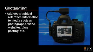
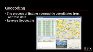
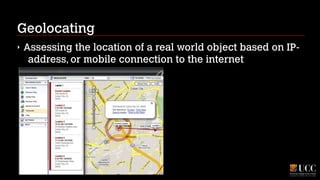
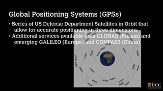
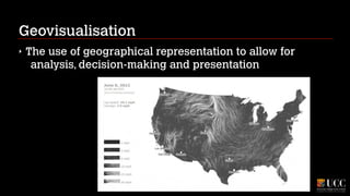
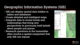
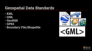
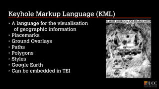
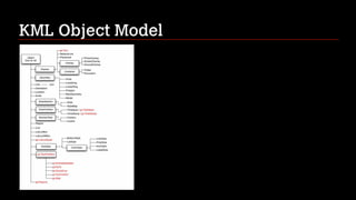
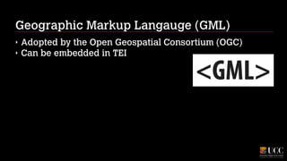
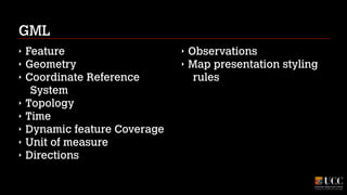
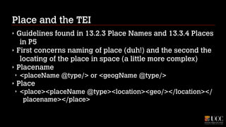
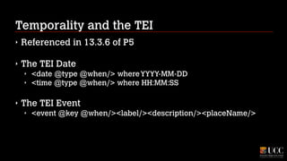
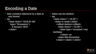
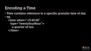
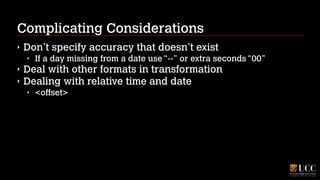
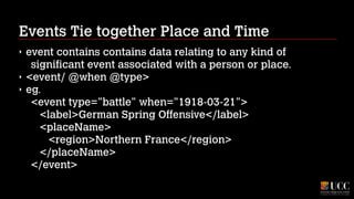
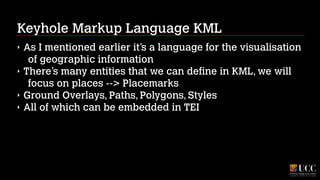
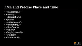
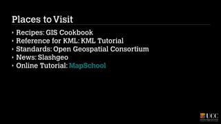
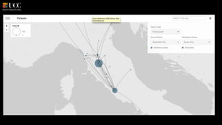
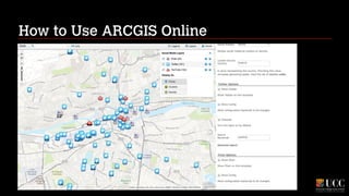
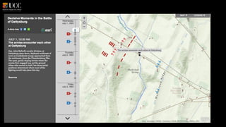
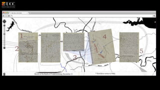
This document discusses spatial data and concepts related to geography, such as place names, locations, and events. It provides an overview of key terms like geocoding, geotagging, and geographic information systems. It also describes how to encode spatial information and temporality in the Text Encoding Initiative (TEI) framework, including using the KML language to embed geographic data. The document recommends resources for learning more about topics like GIS, spatial standards, and tools for working with spatial data.
Deciphering and Documenting Destruction with GIS: Methods of Digital Excavation and Documentation at Tel Beth-Shemesh, Israel
Hai Ashkenazi, Zvi Lederman, Shlomo Bunimovitz, Tel Aviv University
An introduction to GIS Data Types. Strengths and weaknesses of raster and vector data are discussed. Also covered is the importance of topology. Concludes with a discussion of the vector-based format of OpenStreetMap data.
The Socio-Economic Surveys conducted by NSSO are in the form of Rounds, each round being normally of one-year duration though conducted occasionally for a period of six months. The subject coverage of SE inquiries for different rounds is decided on the basis of a 10 year time frame. In this cycle, 1 year is devoted to Land and Livestock Holdings, Debt and Investment; 1 year to Social Consumption (education and health care, etc.), 2 years to quinquennial surveys on household consumer expenditure, employment & un-employment situation and 4 years to non- agricultural enterprises, namely, manufacturing, trade and services in un-organized sector.
The remaining 2 years are for open rounds in which subjects of current/special interest on the demand of Central Ministries, State Governments and research organizations are covered. The rural areas such as (i) interior villages of Nagaland situated beyond five kilometers of the bus route and (ii) villages in Andaman & Nicobar Islands which remain inaccessible throughout year were excluded from coverage of socio-economic survey up till 68th Round of NSS(July 2011-June 2012). Henceforth i.e. from 69th Round onward, the Socio-Economic Survey covers the whole of the Indian Union. Well qualified and trained Investigators of NSSO and the State Governments collect information through enquiry method, using the same methodology & schedules that are specially designed for the survey.
A presentation that explains the various systems and techniques of employing steel and concrete to support long span structures. The range varies from conventional beams, to trusses and portal frames.
This presentation talks about the process of Traffic & Transportation surveys, the bases of delineating Traffic Analysis Zones and the various surveys required to be carried out to understand the traffic behavior of the city.
Earthquake resistant building constructiondaspriyabrata3
1 INTRODUCTION
2 EARTHQUAKE THEORY
3 EARTHQUAKE MAGNITUDE AND ENERGY
4 EFFECTS OF EARTHQUAKES
5 MAJOR EARTHQUAKES
6 NOTABLE EARTHQUAKES AND THEIR ESTIMATED
MAGNITUDE
7 HOW EARTHQUAKE RESISTANT CONSTRUCTION IS
DIFFERENT
8 SEISMIC DESIGN PHILOSOPHY
9 EFFECT OF EARTHQUAKE ON REINFORCED CONCRETE BUILDINGS
10 ROLES OF FLOOR AND MASONRY WALLS SLABS
11 STRENGTH HIERARCHY
12 EARTHQUAKE RESISTANT BUILDING
13 EARTHQUAKE DESIGN PHILOSOPHY
14 REMEDIAL MEASURES TO MINIMISE THE LOSSES DUE TO EARTHQUAKES
15 EARTHQUAKE RESISTANT BUILDING CONSTRUCTION WITH REINFORCED HOLLOW CONCRETE BLOCK(RHCBM)
16 STRUCTURAL FEATURES
17 STRUCTURAL ADVANTAGES
18 CONSTRUCTIONAL ADVANTAGES
19 ARCHITECTURAL AND OTHER ADVANTAGES
20 STUDIES ON THE COMPARATIVE COST ECONOMICS OF RHCBM
21 MID-LEVEL ISOLATION 32-34
22 EARTHQUAKE RESISTANCE BUILDING USING SEISMIC ISOLATION SYSTEMS WITH SLIDING ON CONCAVE SURFACE
23 DESCRIPTION
24 CONCEPT OF FRICTION PENDULUM BEARING
25 SLIDING PENDULUM SEISMIC ISOLATION SYSTEM
26 BACKGROUND OF THE INVENTION
27 BRIEF SUMMARY OF THE INVENTION
28 DETAILED DESCRIPTION OF THE INVENTION
29 ESTIMATION
30 CONCLUSION
31 BIBLIOGRAPHY
Mapping your data can help to provide new insights on your research findings. However, many scholars are put off by the steep learning curve demanded by Geographic Information Systems (GIS) such as ArcGIS from ESRI. New and simple tools have become available that offer sophisticated output without extensive training. In fact, tools such as Google Maps, Google Earth, Open Street Map among others can offer immediate returns in a matter of hours where tasks in the past required, weeks, months and even years of training.
Daniel Shakespeare (Freelance programmer, DE): Interactive Genealogy Explorer. Visualization of migration of ancestors and relatives
co:op-READ-Convention Marburg
Technology meets Scholarship, or how Handwritten Text Recognition will Revolutionize Access to Archival Collections.
With a special focus on biographical data in archives
Hessian State Archives Marburg Friedrichsplatz 15, D - 35037 Marburg
19-21 January 2016
Digital Tools, Trends and Methodologies in the Humanities and Social SciencesShawn Day
This interactive seminar will explore trends and initiatives in the digital community of practice in the humanities and the social sciences. Participants will come away with a appreciation of from where the field has emerged and how it interacts with traditional disciplines. This seminar will be of interest to those in traditional disciplines as well as the wider academy as digital humanities is both collaborative and multidisciplinary in practise. It is intended to form a broad and easy introduction to the practise of digital humanities and will appeal especially to new scholar who is open to the potential to combine their traditional scholarship with digital tools and methodologies. It is *introductory* in nature.
Requirements Engineering for the HumanitiesShawn Day
This workshop explores how requirements engineering can be employed by digital and non-digital humanities scholars (and others) to conceptualise and communicate a research project.
requirementsEngineeringAs the field of digital humanities has evolved, one of the biggest challenges has been getting the marrying technical expertise with humanities scholarly practice to successfully deliver sustainable and sound digital projects. At its core this is a communications exercise. However, to communicate effectively demands an ability to effectively translate, define and find clarity in your own mind.
Google Tools for Digital Humanities ScholarsShawn Day
In this seminar we have introduced many lesser known, but potentially even more useful tools to scholars such as the particularly powerful Google Fusion Tables and Google Trends to the simple but powerful Google Keep among others. This just scrapes the surface with a series of tools that evolve everyday and with new tools emerging and other fading away after contributing to our scholarly imagination.
A brief introduction to Metadata, it’s value and how it can be leveraged in Omeka as a digital narrative tool; and to evaluate what digital narrative tools - such as Omeka or others - may be of use in sharing your research – and telling your story.
2024.06.01 Introducing a competency framework for languag learning materials ...Sandy Millin
http://sandymillin.wordpress.com/iateflwebinar2024
Published classroom materials form the basis of syllabuses, drive teacher professional development, and have a potentially huge influence on learners, teachers and education systems. All teachers also create their own materials, whether a few sentences on a blackboard, a highly-structured fully-realised online course, or anything in between. Despite this, the knowledge and skills needed to create effective language learning materials are rarely part of teacher training, and are mostly learnt by trial and error.
Knowledge and skills frameworks, generally called competency frameworks, for ELT teachers, trainers and managers have existed for a few years now. However, until I created one for my MA dissertation, there wasn’t one drawing together what we need to know and do to be able to effectively produce language learning materials.
This webinar will introduce you to my framework, highlighting the key competencies I identified from my research. It will also show how anybody involved in language teaching (any language, not just English!), teacher training, managing schools or developing language learning materials can benefit from using the framework.
How to Build a Module in Odoo 17 Using the Scaffold MethodCeline George
Odoo provides an option for creating a module by using a single line command. By using this command the user can make a whole structure of a module. It is very easy for a beginner to make a module. There is no need to make each file manually. This slide will show how to create a module using the scaffold method.
This slide is special for master students (MIBS & MIFB) in UUM. Also useful for readers who are interested in the topic of contemporary Islamic banking.
A workshop hosted by the South African Journal of Science aimed at postgraduate students and early career researchers with little or no experience in writing and publishing journal articles.
Acetabularia Information For Class 9 .docxvaibhavrinwa19
Acetabularia acetabulum is a single-celled green alga that in its vegetative state is morphologically differentiated into a basal rhizoid and an axially elongated stalk, which bears whorls of branching hairs. The single diploid nucleus resides in the rhizoid.
Safalta Digital marketing institute in Noida, provide complete applications that encompass a huge range of virtual advertising and marketing additives, which includes search engine optimization, virtual communication advertising, pay-per-click on marketing, content material advertising, internet analytics, and greater. These university courses are designed for students who possess a comprehensive understanding of virtual marketing strategies and attributes.Safalta Digital Marketing Institute in Noida is a first choice for young individuals or students who are looking to start their careers in the field of digital advertising. The institute gives specialized courses designed and certification.
for beginners, providing thorough training in areas such as SEO, digital communication marketing, and PPC training in Noida. After finishing the program, students receive the certifications recognised by top different universitie, setting a strong foundation for a successful career in digital marketing.
Normal Labour/ Stages of Labour/ Mechanism of LabourWasim Ak
Normal labor is also termed spontaneous labor, defined as the natural physiological process through which the fetus, placenta, and membranes are expelled from the uterus through the birth canal at term (37 to 42 weeks
Introduction to AI for Nonprofits with Tapp NetworkTechSoup
Dive into the world of AI! Experts Jon Hill and Tareq Monaur will guide you through AI's role in enhancing nonprofit websites and basic marketing strategies, making it easy to understand and apply.
A review of the growth of the Israel Genealogy Research Association Database Collection for the last 12 months. Our collection is now passed the 3 million mark and still growing. See which archives have contributed the most. See the different types of records we have, and which years have had records added. You can also see what we have for the future.
Macroeconomics- Movie Location
This will be used as part of your Personal Professional Portfolio once graded.
Objective:
Prepare a presentation or a paper using research, basic comparative analysis, data organization and application of economic information. You will make an informed assessment of an economic climate outside of the United States to accomplish an entertainment industry objective.
5. Visual Complexity
Good Examples??
Inspiring Ideas??
!
Complexity?
Patterns?
Aethetics versus Clarity
Can you visualise too much?
What complications does the move into the visual realm
introduce?
10. "Digitization makes the most traditional forms of humanistic
scholarship more necessary, not less.
But the differences mean that we need to reinvent, not
reaffirm, the way we engage with the humanities."
11. Can We Understand Place without Space
‣
Need a wee bit of
background in Geospace
!
‣
‣
‣
‣
‣
‣
More than GIS
Geovisualisation?
Geoparsing?
Georeference
Geoparse
Geotag
‣
‣
‣
‣
‣
‣
Geocode
Geolocate
GPS
GIS
Projection
Geovisualisation
13. Geoparsing
‣
‣
‣
Identifying an entity
as a place as opposed
to another type within
a body of text;
To assign geographic
identifiers to words
and phrases in
unstructured content
Useful Services: Metacarta / Calais / CalaisFull
17. Global Positioning Systems (GPSs)
‣
‣
Series of US Defense Department Satellites in Orbit that
allow for accurate positioning in three dimensions
Additional services available from GLONAS (Russia) and
emerging GALILEO (Europe) and COMPASS (China)
19. Geographic Information Systems (GIS)
‣
‣
‣
‣
GIS can display spatial data hidden in
tables and databases
Create detailed and intelligent maps
Integrate data to reveal trends and
relationships that bring new
perspectives to previously held beliefs
about people and places
Research questions in the humanities
often involve a spatial component that
only GIS can expose
21. Keyhole Markup Language (KML)
‣
‣
‣
‣
‣
‣
‣
‣
A language for the visualisation
of geographic information
Placemarks
Ground Overlays
Paths
Polygons
Styles
Google Earth
Can be embedded in TEI
25. Place and the TEI
‣
‣
‣
Guidelines found in 13.2.3 Place Names and 13.3.4 Places
in P5
First concerns naming of place (duh!) and the second the
locating of the place in space (a little more complex)
Placename
‣
‣
<placeName @type/> or <geogName @type/>
Place
‣
<place><placeName @type><location><geo/></location></
placename></place>
26. Place Naming
‣
placeName contains an absolute or relative place name
to a geo-political reference.
‣
‣
<placeName/ @key>
eg.
‣
<placeName key=”FO-01”>
<settlement type=””town”>OFFOY
</settlement>
<country type=”nation”>France
</country>
</placeName>
27. Place Naming
‣
‣
‣
geogName contains an absolute or relative reference to a
geographic feature.
<geogName/ @key @type>
eg.
‣
<geogName key=”R01” type=”River”>
<name>Somme</name>
<geogFeature>River</geogFeature>
</geogName>
28. Locating a Place
‣
‣
place contains direct reference to the location of a place.
eg.
‣
<place key=”offoy” type=”Town”>
<placeName notBefore=”1450”>OFFOY</placeName>
<location><geo>
<kml:Placemark id=”OFF-01”>
<kml:Point>
<kml:coordinates>49.7634,3.0115
</kml:coordinates></kml:Point>
</kml:Placemark></geo></location
</place>
29. Complicating Considerations
‣
Specifying a Coordinate System (default:WGS84)
‣
‣
Dealing with places with different names at different
times
‣
‣
‣
<placeName notAfter="0056">Lugdunum</placeName>
<placeName notBefore="1400">Lyon</placeName>
Dealing with relative locations
‣
‣
Otherwise use GeoDecl in TEI Header
<offset> or <measure>
Specifying a GML and KML within the TEI
‣
<geo><kml:Placemark/></geo>
30. Temporality and the TEI
‣
Referenced in 13.3.6 of P5
!
‣
The TEI Date
‣
‣
<date @type @when/> where YYYY-MM-DD
<time @type @when/> where HH:MM:SS
!
‣
The TEI Event
‣
<event @key @when/><label/><description/><placeName/>
31. Encoding a Date
‣
‣
date contains reference to a date in
any format.
eg.
<date when=”1918-01-06”
type=”Occassion”>
6 January 1918
</date>
!
!
!
!
!
‣
‣
dates can be relative:
eg.
<date when="--12-02">
<date>A week</date>
<offset>before</offset>
<date when="--12-09">
<date type="occasion">my
birthday
</date> on
<date>9th December
</date></date></date>
32. Encoding a Time
‣
‣
Time contains reference to a specific granular time of day.
eg.
<time when=”13:45:00”
type=”twentyfourHour”>
a quarter of two
</time>
33. Complicating Considerations
‣
Don’t specify accuracy that doesn’t exist
‣
‣
‣
If a day missing from a date use “--” or extra seconds “00”
Deal with other formats in transformation
Dealing with relative time and date
‣
<offset>
34. Events Tie together Place and Time
‣
‣
‣
event contains contains data relating to any kind of
significant event associated with a person or place.
<event/ @when @type>
eg.
<event type="battle" when="1918-03-21">
<label>German Spring Offensive</label>
<placeName>
<region>Northern France</region>
</placeName>
</event>
35. Keyhole Markup Language KML
‣
‣
‣
‣
As I mentioned earlier it’s a language for the visualisation
of geographic information
There’s many entities that we can define in KML, we will
focus on places --> Placemarks
Ground Overlays, Paths, Polygons, Styles
All of which can be embedded in TEI
36. KML and Precise Place and Time
‣
‣
‣
‣
‣
‣
‣
‣
‣
‣
‣
<placemark/>
<name/>
<description/>
<point>
<coordinates/>
<timeStamp/>
<timeSpan/>
<when/>
<begin/><end/>
<Folder/>
<Document/>
37. Places to Visit
‣
‣
‣
‣
‣
Recipes: GIS Cookbook
Reference for KML: KML Tutorial
Standards: Open Geospatial Consortium
News: Slashgeo
Online Tutorial: MapSchool
42. for Next Lecture (11 March):
Presenting Complex Data Objects
Please take a look at:
!
How Collaboration Works and How it Can Fail
DH Contribution to Topic Modeling