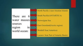
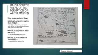
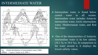
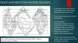
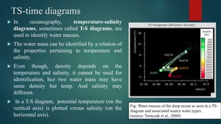
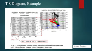
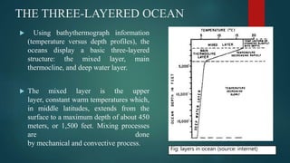
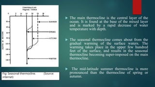
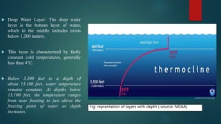
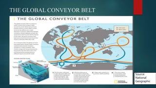
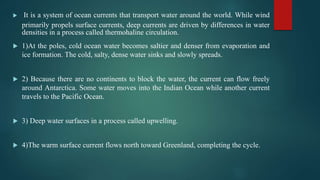
Water mass
Author:
ANUJ SHARMA
Kerala University of Fisheries and Ocean Studies,
Kerala
Definition
 An oceanographic water mass is an identifiable body, in terms of density,
of water with a common formation history which has physical properties
distinct from surrounding water.
 Water mass are stable, large water bodies and for their formation, water has
to sink down/ strong downwelling.
 It is defined on the basis of uniform density, not in terms of temperature or
salinity.
 A water type has a single value of salinity and a single value of
temperature associated with it, while a water mass takes into account a
range of temperatures and salinities. For eg..
cont...
Cont.....
 Red Sea water (lying between Africa and Asia) is a water type
characterized by a temperature of 9°C and a salinity of 35.5 ‰. On the
other hand, North Atlantic Central Water (a water mass) is characterized
by a range of temperatures (4°C to 17°C) and salinity (35.1 ‰ to 36.2
‰).
 A water mass may be considered to be made up of a combination of two
or more water types.
Formation
 majority of water masses are formed in the polar latitudes, and are not formed
in tropical waters and temperate waters.
 Cold, highly dense surface water sinks, spreads out horizontally, until it reaches
a level having the same constant density. The manner in which it spreads out
depends on its density in relation to the density of the surrounding water.
 Downwelling is more required for water mass formation and more pronounced
under: a) brine extraction process, b) in absences of Pycnocline (not well
developed in Polar region)
Common water masses in the world ocean
Antarctic bottom water ( AABW), North Atlantic Deep
Water(NADW), Circumpolar Deep Water(CDW), Antarctic Intermediate
Water(AAIW),
Subantarctic Mode Water (SAMW), Arctic Intermediate Water (AIW),
North Pacific Intermediate Water (NPIW), the central waters of
various oceanic basins, and various ocean surface waters.
 Different regions with different temperatures form water masses. Some
water masses are more dense than others depending on salinity. Freshwater
will float because it is less dense than salt water.
There are 6
water masses
sources
region in
world ocean:
North Pacific ( near Aleutian Island)
South Pacific(ANTARTICA)
Norweigian Sea
East Greenland(Arctic region)
Weddell Sea( Antartica)
Lazarev Sea( Part of Antartic Basin)
Source: internet
Distribution
 In low and middle latitudes the vertical arrangement of water is such that we can
distinguish a surface layer, upper water (central and equatorial), intermediate water,
deep water, and in some localities, bottom water.
 SURFACE LAYER: properties vary widely from one area to another, depending
on current variations, evaporation, precipitation, and various seasonal changes,
especially in the middle latitudes, so, not classified as a water mass or water
type. The surface layer is separated from deeper water by a transition layer
(the main thermocline)
 CENTRAL WATER MASSES: found in relatively low latitudes although its source
region is in the region of the subtropical convergence. Central water is not usually
discernible at the surface and is generally relatively shallow. Its greatest thickness
is observed along its western boundaries.
Cont.....
EQUATORIAL WATER
MASSES: found in the Pacific and in
the Indian Ocean. In the Pacific it is
thought to originate on the southern
side of the equator.
Equatorial water is found in the
northern part of the Indian Ocean is
having higher salinities, probably
due to its mixing with the waters of
the Red Sea.
Cont....
Fig: Global distribution of upper waters (0-500 m). (source- Emery
et al.,2001)
INTERMEDIATE WATER
 Intermediate water is found below
central water in all oceans.
Intermediate water includes Antarctic
intermediate water, Arctic intermediate
water, Mediterranean water, and Red
Sea water.
 One of the characteristics of Antarctic
intermediate water is its low salinity
(34.1 ‰ to 34.6 ‰). In comparison to
the water around it, it displays the
lowest salinity values.Fig: Global distribution of intermediate water (1000-
3000m) ( source: Emery et al.,2001 )
DEEP AND BOTTOM WATER MASSES.
• In the deep ocean basins below
intermediate water, high density
deep and bottom water exists.
• These water masses form in both
hemispheres.
• In the Southern
Hemisphere, Antarctic bottom
water forms near the Antarctic
continent, while in the Northern
Hemisphere, Arctic deep and
bottom water forms in
northwestern Labrador Basin
• These water masses form at the
surface, sink, and spread out to fill
the deep-ocean basins.
FIg: Global distribution of deep and abyssal waters (3000....)bottom.
(Source: Emery et al.,2001)
TS-time diagrams
 In oceanography, temperature-salinity
diagrams, sometimes called T-S diagrams, are
used to identify water masses.
 The water mass can be identified by a relation of
the properties pertaining to temperature and
salinity.
 Even though, density depends on the
temperature and salinity, it cannot be used for
identification, bcz two water mass may have
same density but temp. And salinity may
different.
 In a T-S diagram, potential temperature (on the
vertical axis) is plotted versus salinity (on the
horizontal axis).
Fig: Water masses of the deep ocean as seen in a TS-
diagram and associated source water types.
(source: Tomczak et al., 2000)
T-S Diagram, Example
Source: Coursera
THE THREE-LAYERED OCEAN
 Using bathythermograph information
(temperature versus depth profiles), the
oceans display a basic three-layered
structure: the mixed layer, main
thermocline, and deep water layer.
 The mixed layer is the upper
layer, constant warm temperatures which,
in middle latitudes, extends from the
surface to a maximum depth of about 450
meters, or 1,500 feet. Mixing processes
are done
by mechanical and convective process.
Fig: layers in ocean (source: internet)
 The main thermocline is the central layer of the
ocean. It is found at the base of the mixed layer
and is marked by a rapid decrease of water
temperature with depth.
 The seasonal thermocline comes about from the
gradual warming of the surface waters. The
warming takes place in the upper few hundred
feet of the surface, and results in the seasonal
thermocline becoming super-imposed on the main
thermocline.
 The mid-latitude summer thermocline is more
pronounced than the thermocline of spring or
autumn.
Fig: Seasonal thermocline. (Source:
internet)
 Deep Water Layer: The deep water
layer is the bottom layer of water,
which in the middle latitudes exists
below 1,200 meters.
 This layer is characterized by fairly
constant cold temperatures, generally
less than 4°C.
 Below 3,300 feet to a depth of
about 13,100 feet, water temperature
remains constant. At depths below
13,100 feet, the temperature ranges
from near freezing to just above the
freezing point of water as depth
increases.
Fig: reprentation of layers with depth ( source: NOAA)
THE GLOBAL CONVEYOR BELT
Source:
National
Geographic
 It is a system of ocean currents that transport water around the world. While wind
primarily propels surface currents, deep currents are driven by differences in water
densities in a process called thermohaline circulation.
 1)At the poles, cold ocean water becomes saltier and denser from evaporation and
ice formation. The cold, salty, dense water sinks and slowly spreads.
 2) Because there are no continents to block the water, the current can flow freely
around Antarctica. Some water moves into the Indian Ocean while another current
travels to the Pacific Ocean.
 3) Deep water surfaces in a process called upwelling.
 4)The warm surface current flows north toward Greenland, completing the cycle.
Thank you
For more information,
Contact no.: 9466332592
Mail id: ab132041@gmail.com

Water mass

  • 1.
    Water mass Author: ANUJ SHARMA KeralaUniversity of Fisheries and Ocean Studies, Kerala
  • 2.
    Definition  An oceanographicwater mass is an identifiable body, in terms of density, of water with a common formation history which has physical properties distinct from surrounding water.  Water mass are stable, large water bodies and for their formation, water has to sink down/ strong downwelling.  It is defined on the basis of uniform density, not in terms of temperature or salinity.  A water type has a single value of salinity and a single value of temperature associated with it, while a water mass takes into account a range of temperatures and salinities. For eg.. cont...
  • 3.
    Cont.....  Red Seawater (lying between Africa and Asia) is a water type characterized by a temperature of 9°C and a salinity of 35.5 ‰. On the other hand, North Atlantic Central Water (a water mass) is characterized by a range of temperatures (4°C to 17°C) and salinity (35.1 ‰ to 36.2 ‰).  A water mass may be considered to be made up of a combination of two or more water types.
  • 4.
    Formation  majority ofwater masses are formed in the polar latitudes, and are not formed in tropical waters and temperate waters.  Cold, highly dense surface water sinks, spreads out horizontally, until it reaches a level having the same constant density. The manner in which it spreads out depends on its density in relation to the density of the surrounding water.  Downwelling is more required for water mass formation and more pronounced under: a) brine extraction process, b) in absences of Pycnocline (not well developed in Polar region)
  • 5.
    Common water massesin the world ocean Antarctic bottom water ( AABW), North Atlantic Deep Water(NADW), Circumpolar Deep Water(CDW), Antarctic Intermediate Water(AAIW), Subantarctic Mode Water (SAMW), Arctic Intermediate Water (AIW), North Pacific Intermediate Water (NPIW), the central waters of various oceanic basins, and various ocean surface waters.  Different regions with different temperatures form water masses. Some water masses are more dense than others depending on salinity. Freshwater will float because it is less dense than salt water.
  • 6.
    There are 6 watermasses sources region in world ocean: North Pacific ( near Aleutian Island) South Pacific(ANTARTICA) Norweigian Sea East Greenland(Arctic region) Weddell Sea( Antartica) Lazarev Sea( Part of Antartic Basin)
  • 7.
  • 8.
    Distribution  In lowand middle latitudes the vertical arrangement of water is such that we can distinguish a surface layer, upper water (central and equatorial), intermediate water, deep water, and in some localities, bottom water.  SURFACE LAYER: properties vary widely from one area to another, depending on current variations, evaporation, precipitation, and various seasonal changes, especially in the middle latitudes, so, not classified as a water mass or water type. The surface layer is separated from deeper water by a transition layer (the main thermocline)  CENTRAL WATER MASSES: found in relatively low latitudes although its source region is in the region of the subtropical convergence. Central water is not usually discernible at the surface and is generally relatively shallow. Its greatest thickness is observed along its western boundaries. Cont.....
  • 9.
    EQUATORIAL WATER MASSES: foundin the Pacific and in the Indian Ocean. In the Pacific it is thought to originate on the southern side of the equator. Equatorial water is found in the northern part of the Indian Ocean is having higher salinities, probably due to its mixing with the waters of the Red Sea. Cont.... Fig: Global distribution of upper waters (0-500 m). (source- Emery et al.,2001)
  • 10.
    INTERMEDIATE WATER  Intermediatewater is found below central water in all oceans. Intermediate water includes Antarctic intermediate water, Arctic intermediate water, Mediterranean water, and Red Sea water.  One of the characteristics of Antarctic intermediate water is its low salinity (34.1 ‰ to 34.6 ‰). In comparison to the water around it, it displays the lowest salinity values.Fig: Global distribution of intermediate water (1000- 3000m) ( source: Emery et al.,2001 )
  • 11.
    DEEP AND BOTTOMWATER MASSES. • In the deep ocean basins below intermediate water, high density deep and bottom water exists. • These water masses form in both hemispheres. • In the Southern Hemisphere, Antarctic bottom water forms near the Antarctic continent, while in the Northern Hemisphere, Arctic deep and bottom water forms in northwestern Labrador Basin • These water masses form at the surface, sink, and spread out to fill the deep-ocean basins. FIg: Global distribution of deep and abyssal waters (3000....)bottom. (Source: Emery et al.,2001)
  • 12.
    TS-time diagrams  Inoceanography, temperature-salinity diagrams, sometimes called T-S diagrams, are used to identify water masses.  The water mass can be identified by a relation of the properties pertaining to temperature and salinity.  Even though, density depends on the temperature and salinity, it cannot be used for identification, bcz two water mass may have same density but temp. And salinity may different.  In a T-S diagram, potential temperature (on the vertical axis) is plotted versus salinity (on the horizontal axis). Fig: Water masses of the deep ocean as seen in a TS- diagram and associated source water types. (source: Tomczak et al., 2000)
  • 13.
  • 14.
    THE THREE-LAYERED OCEAN Using bathythermograph information (temperature versus depth profiles), the oceans display a basic three-layered structure: the mixed layer, main thermocline, and deep water layer.  The mixed layer is the upper layer, constant warm temperatures which, in middle latitudes, extends from the surface to a maximum depth of about 450 meters, or 1,500 feet. Mixing processes are done by mechanical and convective process. Fig: layers in ocean (source: internet)
  • 15.
     The mainthermocline is the central layer of the ocean. It is found at the base of the mixed layer and is marked by a rapid decrease of water temperature with depth.  The seasonal thermocline comes about from the gradual warming of the surface waters. The warming takes place in the upper few hundred feet of the surface, and results in the seasonal thermocline becoming super-imposed on the main thermocline.  The mid-latitude summer thermocline is more pronounced than the thermocline of spring or autumn. Fig: Seasonal thermocline. (Source: internet)
  • 16.
     Deep WaterLayer: The deep water layer is the bottom layer of water, which in the middle latitudes exists below 1,200 meters.  This layer is characterized by fairly constant cold temperatures, generally less than 4°C.  Below 3,300 feet to a depth of about 13,100 feet, water temperature remains constant. At depths below 13,100 feet, the temperature ranges from near freezing to just above the freezing point of water as depth increases. Fig: reprentation of layers with depth ( source: NOAA)
  • 17.
    THE GLOBAL CONVEYORBELT Source: National Geographic
  • 18.
     It isa system of ocean currents that transport water around the world. While wind primarily propels surface currents, deep currents are driven by differences in water densities in a process called thermohaline circulation.  1)At the poles, cold ocean water becomes saltier and denser from evaporation and ice formation. The cold, salty, dense water sinks and slowly spreads.  2) Because there are no continents to block the water, the current can flow freely around Antarctica. Some water moves into the Indian Ocean while another current travels to the Pacific Ocean.  3) Deep water surfaces in a process called upwelling.  4)The warm surface current flows north toward Greenland, completing the cycle.
  • 19.
    Thank you For moreinformation, Contact no.: 9466332592 Mail id: ab132041@gmail.com