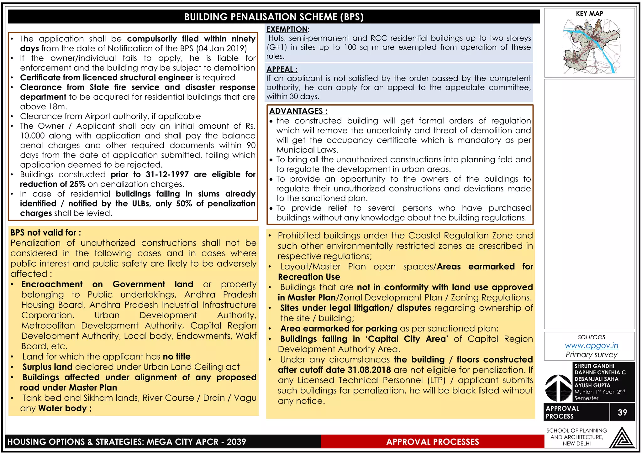
Downloaded 50 times
![02
LEGEND
z
HOUSING OPTIONS & STRATEGIES: MEGA CITY APCR - 2039
SCHOOL OF PLANNING
AND ARCHITECTURE,
NEW DELHI
ORGANIZATIONAL
SETUP
KEY MAP
DEBANJALI SAHA
AYUSH GUPTA
DAPHNE C
SHRUTI GANDHI
M. Plan 1st Year, 2nd Semester
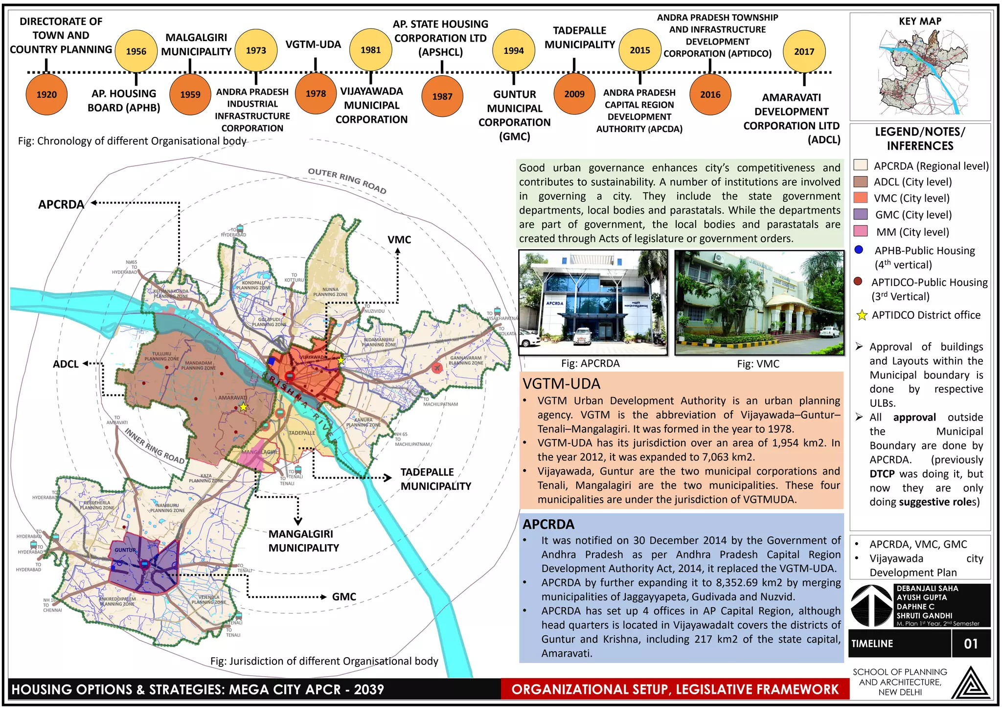
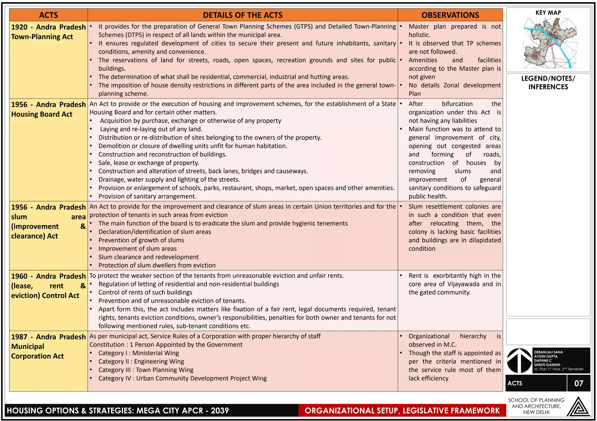
Ministry of
Housing
and Urban AffairsAPPRAISAL
AGENCIES
GOVERNMENT
OF INDIA
PLAN
PREPARATION
AND
IMPLEMENTATION
MONITORING
AGENCIES
• REFORMS
• PROJECTS
Andra
Pradesh
Industrial
Infrastructure
Corporation
(APIIC) (1973)
• Look into
Master
Plan
• CLU
Director of
Planning
• Trunk
Infrastructure
• Green
Master plan
and Blue
Master Plan
Director of
Development
& promotion
Andra Pradesh
Township and
Infrastructure
Development
Corporation
(APTIDCO) (2016)
Amaravati
Development
Corporation
Limited
(ADCL)
Approval of :
• Layout (21days)
• Building
(15days)
GOVERNMENT OF ANDRA PRADESH
• Affordable housing in
Partnership (3rd Vertical of
PMAY)
• Infrastructure
• Integrated Township planning
with all income groups (walk to
work concept) [presently not
functioning]
Directorate of
Town and
Country Planning
(DTCP)-1920
• Conducted survey
and finds out the
housing shortage of
all classes
(Bhavanipuram
Project, Vijayawada)
• Provide houses along
with the other
facilities (presently
not functioning)
• Provides
PMAY
Beneficiary
Led
Construction
(4th Vertical)
• NTR-Rural
Housing
HUDCO
Zilla Panchayat
District collector
BENIFICIARYSELECTION,
OPERATION&MAINTEINANCE
Block Samiti
Janpad Panchayat
DISTRICT LEVEL
Commissioner
Establishment Engineering Estate Town
Planning
Revenue
Property Tax
VIJAYAWADA MUNICIPAL
CORPORATION
GUNTUR MUNICIPAL
CORPORATION
TADEPALLI
MUNICIPALITY
MANGALGIRI
MUNICIPALITY
CITY LEVELAdministration
Section
• Vacancies
• Appointments
• Pay
• Allowances
• Audit report
Revenue
Section
• Demand, collection,
Balance.
• Land acquisition.
• Land conversion
• Regularization of
encroachments
Election
section
• Integrated development
of small and medium
towns
• Slum area development
Census
section
Census subjects
(excluding Demographic
Profile)
• A number of
institutions are
involved in the
governance of
Vijayawada city,
Guntur, Mangalgiri,
Tadepalli and the
surrounding peri-
urban areas that
constitute the Urban
Agglomeration.
• Some of them were
established through
Acts of legislature and
others are part of
state’s governance
framework.
ORGANIZATIONAL SETUP, LEGISLATIVE FRAMEWORK
THREE-TIERSYSTEM
APCRDA, DTCP, VMC,
APTIDCO- offices.
• The Municipal Acts list the functions under two categories, namely,
“obligatory functions” and “discretionary functions”.
• The functional domain was expanded in 1994 as per the 12th Schedule
of the 74th Constitution Amendment Act.
• In Andhra Pradesh, the Municipalities and Corporation Acts provide for a
majority of the functions listed in the 12th Schedule of the constitution.
Policy Directly linked.
Technical Support
and Advice
Project Proposal Flow
Municipal Administration & Urban
Development Department
AP. Housing
Board (1956)
AP. State
Housing
Corporation Ltd.
(1987)
Andra Pradesh Capital
Region Development
Authority (APCRDA)
2015
• Nodal agency
for online
approval
• Technical
assistance
and support
CENTRAL LEVEL STATE LEVEL
REGIONAL
LEVEL
Municipal
section
FOR CONSTRUCTION
INFERENCES](https://image.slidesharecdn.com/organizationalsetupd-190930155808/75/Vijayawada-Organizational-setup-and-Development-control-regulations-2-2048.jpg)
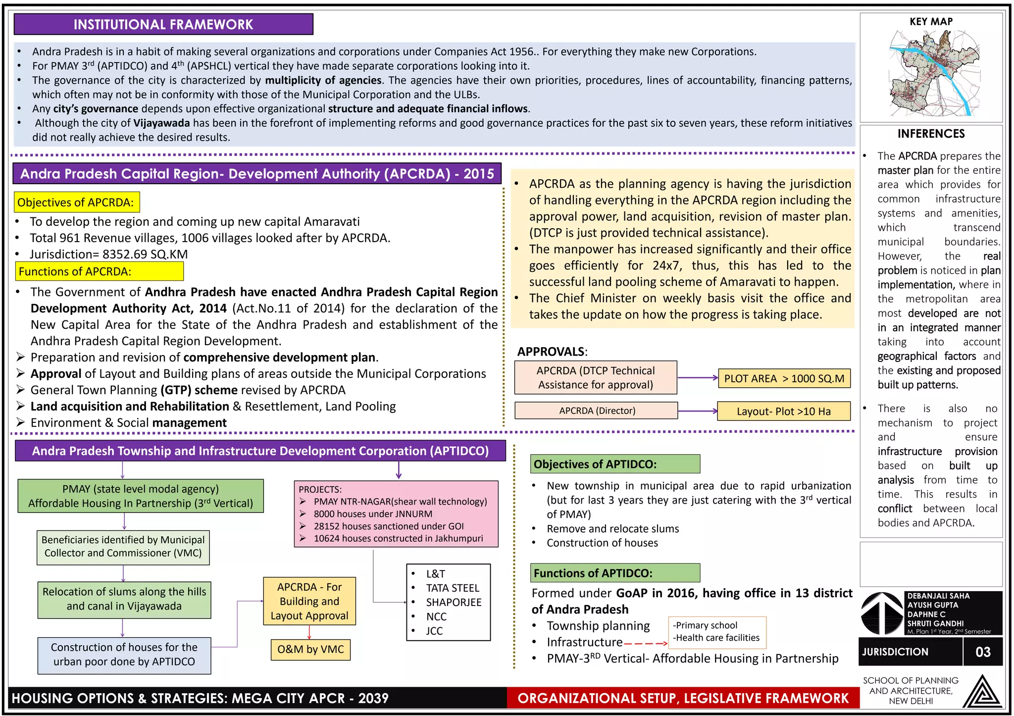
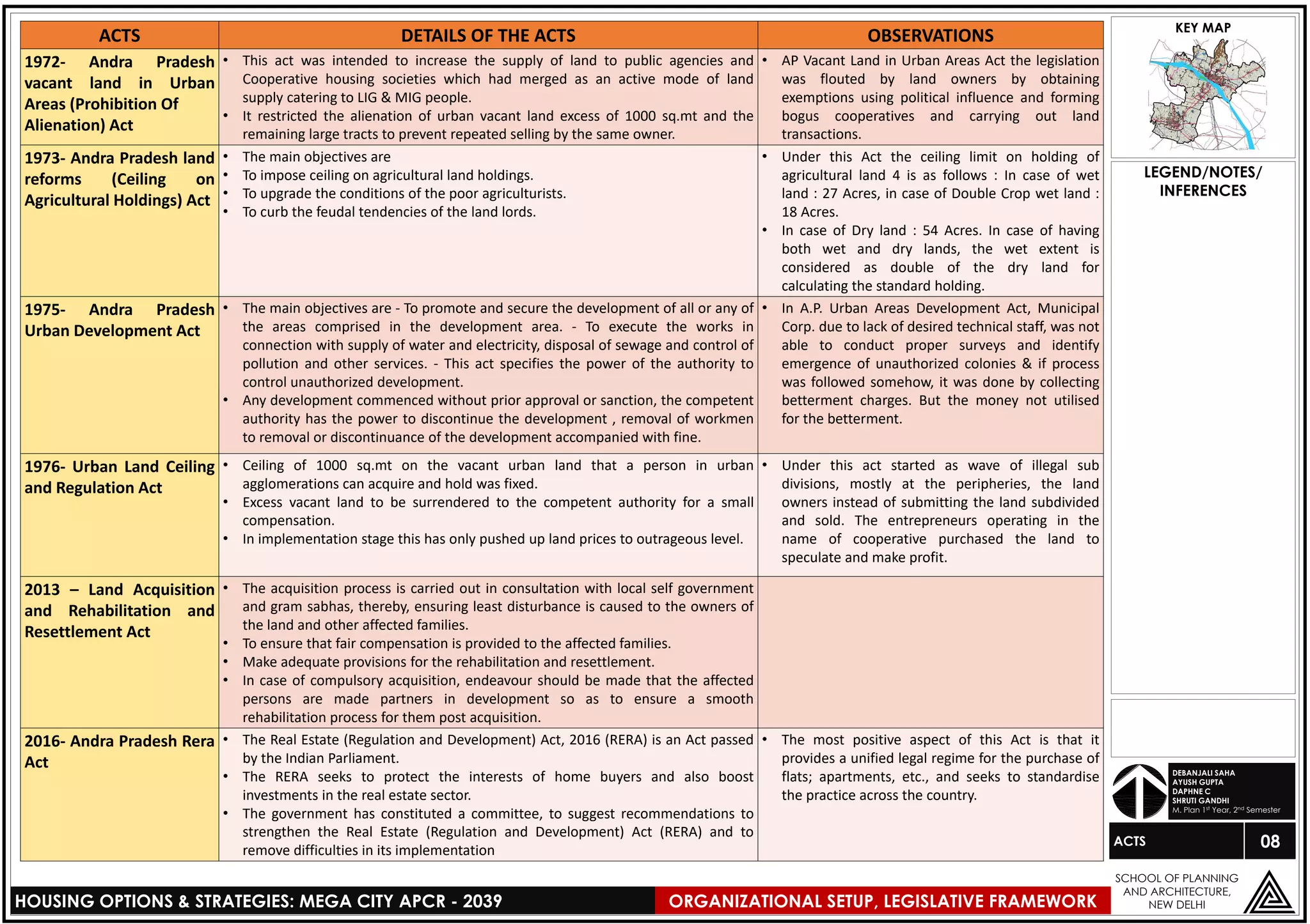
![4. If doesn’t
moves, then
removal done by
Police Power under
Law. 05
LEGEND/NOTES/
INFERENCES
z
HOUSING OPTIONS & STRATEGIES: MEGA CITY APCR - 2039
SCHOOL OF PLANNING
AND ARCHITECTURE,
NEW DELHI
JURISDICTION
KEY MAP
DEBANJALI SAHA
AYUSH GUPTA
DAPHNE C
SHRUTI GANDHI
M. Plan 1st Year, 2nd Semester
VIJAYAWADA MUNICIPAL CORPORATION :
Commissioner
ACP II
ACP I
Building Inspectors
(Initial Officer)
PLOT SIZE APPROVED BY:
• <200 SQ.M Building Inspector
• 200-500 SQ.M City Planner
• >500 SQ.M Commissioner
Town Planning Section
Jurisdiction: 61.88 SQ.KM
The Vijayawada, Guntur, Tadepalle and Mangalagiri Metropolitan Area consists the areas under the Municipal Corporation of Vijayawada and Guntur
and other municipalities viz. Tadepalli (2nd grade) and Mangalagiri (2nd grade) and several other gram panchayats and villages. It is governed/
administered by Andra Pradesh Capital Region Development Authority (APCRDA).
Deputy
Commissioner
Engineering Section
Plot >200 sq.m. = DTCP
Plot <200 sq.m. = GMC
(Commissioner)
Municipal
Commissioner
Supdt. Engineer
Director of Economics and
Statistic (Socio economic
Profile)
District Collector appoints different people
for the collection of data
(Eg. Govt. Employees)
District Mandal
(Assi. Statistical Engineer)
[update data in the district
handbook every year]
GUNTUR MUNICIPAL CORPORATION (GMC)
1. negotiation with the Slum
union leader, political persons
(MLA, Ward members)– Done by
the Commissioner or Collector.
FOR SLUMS RESETTLEMENT IN AND AROUND VMC:
3. After 3-4 days the
settlement is removed
and free food, shelter,
water and vehicles are
provided till they shift to
the new resettlement
colony.
5. If doesn’t
moves, then
removal done
by Police Power
under Law.
PLOT AREA BENIFICIARY CONTRIBUTION BANK LOAN BHK
300 SQ. FT. Rs 500 2.65 lakhs 1 bhk
365 SQ. FT. Rs 50,000 3.15 lakhs 1 bhk
420 SQ.FT. Rs 1 Lakh 3.65 lakhs 2 bhk
For SLUMS:
Guntur
Municipal
Corporation
Government
of Andra
Pradesh
Beneficiary
selected by the
District level
Committee
Approval by
APCRDA
Allotment of Building
according to lottery system
conducted by NIC
APTIDCO for
Construction
AFFORDABLE HOUSING (3rd vertical):
BENIFICIARY LEAD CONSTRCUCTION (4th Vertical):
1.5 LAKHS Government of India
1.5 LAKHS Government of Andra Pradesh
3LAKHS
PLOT AREA < 1000 SQ.M
VMC (DTCP Technical
Assistance)
Layout- Plot <10 Ha
VMC
(DTCP Technical Assistance for
approval)
2. Two-Three meetings
are conducted and factors
like employment facility,
vocational training
program etc. are issued.
Slum DepartmentEngineeringCommissioner
• All approvals/sanctions of buildings and
layout within the municipal boundary is
done by VMC.
• Choosing of beneficiary for different
schemes
• Operation and maintenance of public
housing and infrastructure
•There is a lack of
coordination between
urban local bodies and
parastatals in areas such as
inter-municipal, inter-
district and inter-state
roads etc.
• It is necessary to have
two pronged
approaches for the
reforms, the first
creating a front end,
the next strengthening
the back end to
effectively cater to the
front end.
• On reality, what is
happening in the case
of Vijayawada is that
front end systems have
been created but the
back end systems have
not been effectively
upgraded/ geared up
to meet the influx of
the kind of
information/
complaints that came
through the same.
• The result is improper
functioning of the
system as a whole
ORGANIZATIONAL SETUP, LEGISLATIVE FRAMEWORK](https://image.slidesharecdn.com/organizationalsetupd-190930155808/75/Vijayawada-Organizational-setup-and-Development-control-regulations-5-2048.jpg)


![18
LEGEND/NOTES/
INFERENCES
Ayush Gupta
Daphne Cynthia
Debanjali Saha
Shruti Gandhi
M.Plan, 1st Year, 2nd Semester
z
HOUSING OPTIONS & STRATEGIES: MEGA CITY APCR - 2039
SCHOOL OF PLANNING
AND ARCHITECTURE,
NEW DELHI
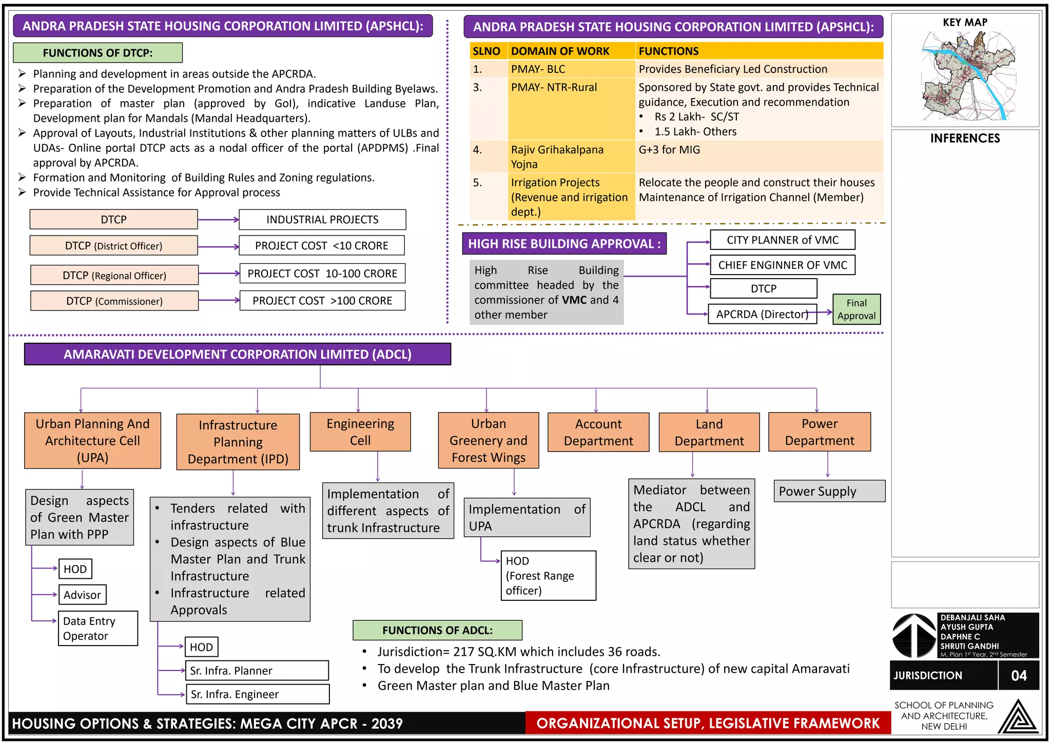
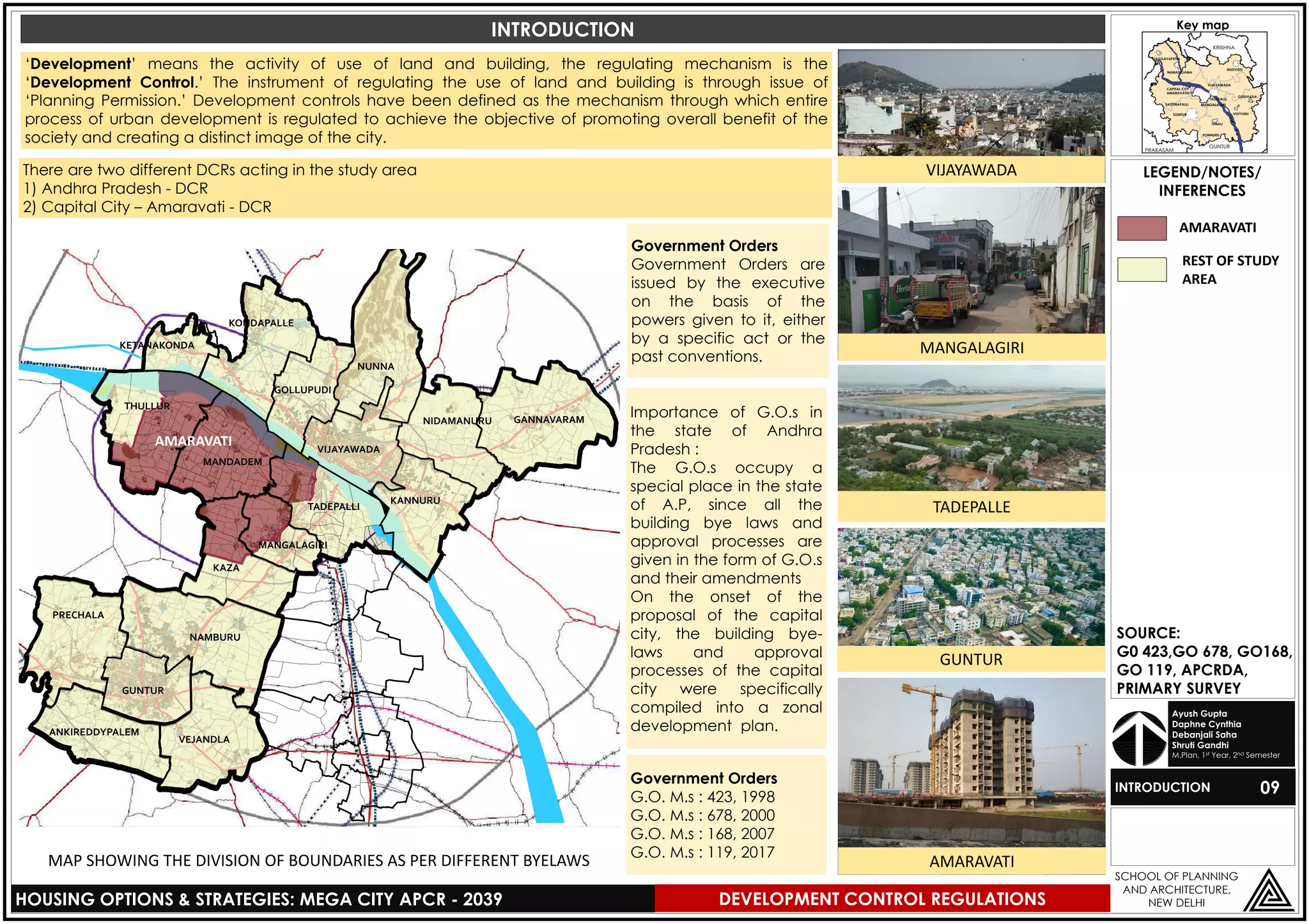
HIGH RISE
Key map
S.no
Height of Building
in meters
Minimum abutting
road width
(in meters)
All round
Setbacks
(in meters)Above upto
1 18 21 12 7
2 21 24 12 8
3 24 27 18 9
4 27 30 18 10
5 30 35 24 11
6 35 40 24 12
7 40 45 24 13
8 45 50 30 14
9 50 55 30 15
After 55m 0.5m additional setback for every 5m of height shall be insisted
SETBACKS FOR HIGH RISE BUILDINGS
Minimum Plot Area: 2000 sq m.
Access Road: Minimum width of 12 m
Applications:
•There shall be no restriction on the maximum permissible height
of any Multi-storied Buildings subject to multi-storeyed building
regulations and necessary clearance from Fire Services Dept.
And National Airport Authority.
Location & Plot Area:
• Minimum Plot Area: 1000 sq m. & Min. Width of plot-12m
• Access Road: Minimum width of 12 m
Applications:
• Prior Clearance from Airport Authority
• Prior No Objection Certificate (NOC) from the Andhra Pradesh
State Disaster Response & Fire Services Department
[APSDR&FSD]
Location & Plot Area:
•High Rise Buildings/Complexes shall be permissible only in areas
notified by the sanctioning Authority with prior approval from the
competent Authority from time to time.
•High rise Buildings shall not be permissible in congested areas
and in gram kantam areas.
• Minimum Plot Area: 2000 sq m.
• Access Road: Minimum width of 12 m
SOURCE:
G0 423(1998) Practised
in Vijaywada,ZDP 2007.
& Andhra Pradesh
Building Rules 2017
(GO 119), (GO 223)
HIGH RISE BUILDINGS
G0.423(1998)G0.119(2107)
1. Tower and Podium Type Building:
i) Height of the building shall be allowed up to 50m.
ii)For Podium, i.e., Ground plus first floor: all-round setbacks
shall be 7m.
iii) For Tower block: The maximum coverage shall be 50 % of
the Podium Block i.e. setback area shall be at least 50% of
the Podium Block subject to a minimum of 3m on any side.
iv) No projection shall be made into the setback.
v) The fire safety and fire escape measures for the Tower
Block shall be independent of the Podium Block.
2. “Stepped Type” or “Pyramidal Type” Building:
i) Such type of High Rise Building blocks may be allowed for
heights above 30m with the following open space
requirements:
ii)At Ground level: Minimum 9m all round open space for the
first five floors.
iii) At Upper floors: Increase of 2m all round open space or
more, for every 5 upper floors or 15m height or part
thereof, over and above the ground level open space of
minimum 9m.
iv) No projection shall be made into the setback.
SPECIAL TYPE OF HIGH RISE BUILDINGS
• The open space to be left between two blocks shall be
equivalent to the Setback and this shall not be considered
for organized open space (Tot lot).
• In case of high rise buildings up to 30m height, it is
permitted to transfer up to 2m of setback from one side to
the other side, which needs to be uniform at any given
point, subject to maintaining the minimum setback of 7m
on all sides and not exceeding the permissible/allowable
plinth area.
• Buildings abutting major road of 30m and above width shall
be permitted only after providing black-topped service
roads of minimum 7m width with minimum 2 Lane
carriageway within the defined right of way. It will be the
responsibility of the developer/builder/owner to provide
the above service road of the standards fixed by the
Sanctioning Authority at his own cost.
• Parking floors in High rise buildings are excluded from
calculation of height of building.
HIGH RISE DEVELOPMENT
MULTI-STORIED BUILDINGS
• As compared to non-
high rise buildings with
specific setbacks for
front, rear and side
setbacks, high rise
building have common
all round setbacks.
• All round setbacks are
provided to ensure fire
tender movement.
DEVELOPMENT CONTROL REGULATION](https://image.slidesharecdn.com/organizationalsetupd-190930155808/75/Vijayawada-Organizational-setup-and-Development-control-regulations-18-2048.jpg)


The document outlines the organizational structure and governance of urban development in the Andhra Pradesh capital region, focusing on agencies like the Andhra Pradesh Capital Region Development Authority (APCRDA) and Vijayawada-Guntur-Tenali-Mangalagiri Urban Development Authority (VGTM-UDA). It details the functions, jurisdiction, and legislative framework involved in urban planning and housing strategies. Specific challenges related to coordination among different agencies and the impact of rapid urbanization are also highlighted, emphasizing the need for effective governance and implementation of housing projects.


![[Urban Management Program City Paper : Kathmandu, Nepal]](https://cdn.slidesharecdn.com/ss_thumbnails/pyuthanurbanmanagementfinal-141112203116-conversion-gate02-thumbnail.jpg?width=640&height=640&fit=bounds)


