SlideShare a Scribd company logo
COMPENDIUM
URBAN DESIGN
Llewelyn-Davies
urban design compendium
english partnerships
the housing corporation
llewelyn - davies
22375H urban design MASTER:22375H urban design MASTER 01/08/2007 10:22 Page 1
2 urban design compendium
english partnerships
English Partnerships is the national force for regeneration and
development.Our aim is to deliver high-quality,well-designed,sustainable
places for people to live,work and enjoy.English Partnerships firmly
believes in the importance of good urban design and environmental
sustainability.Through policy developments we encourage:sustainable
approaches to living throughout our developments,;a mix of uses and
tenures to create lively places to live and work;and innovation in design
and construction of the built environment.Through collaborative design
workshops new developments will enjoy:vibrant,but safe,streets and
places;and high-quality public realm.By encouraging an inclusive approach
to design we can create environments that can meet the needs of all users.
In this way,English Partnerships can continue to play an important role in
promoting best practice in design quality and sustainability in the
regeneration and development industry.
the housing corporation
The Housing Corporation regulates Registered Social Landlords (RSLs)
in England and invests in the new housing that they provide.The
Corporation’s role and strategy reflect the rapid growth of the RSL sector.
This is a result of both the transfer of local authority housing to new or
existing RSLs and of new development and regeneration,supported with a
mix of public and private funding.In all aspects of RSLs’work,the
Corporation encourages quality in design and service standards and
recognises the need for close co-operation with residents and other
agencies. This is to ensure that resources are used to best effect to create
sustainable communities.
Urban Design Alliance:Message of Support
The Urban Design Alliance (UDAL) is delighted to support English
Partnerships and the Housing Corporation in the second edition of the
Urban Design Compendium 1 and the new publication of Urban Design
Compendium 2.UDAL brings together professional and membership
organisations committed to improving the quality of urban life through
urban design,aiming to foster greater awareness and higher standards.
Urban Design Compendium 2,like the first volume,will make a significant
contribution to achieving these goals,helping developers and other
practitioners achieve good design through best practice and creative
thinking.The Compendium is an important document for developers,urban
designers,planners,architects,surveyors,landscape architects,engineers,
building conservationists and a wide range of other people concerned with
improving the built environment.
22375H urban design MASTER:22375H urban design MASTER 01/08/2007 10:22 Page 2
urban design compendium 3
1 the fundamentals contents
1 the fundamentals 6
1.1 The Importance of Urban Design 10
1.2 Key Aspects of Design 12
1.3 How the Compendium is Organised 14
2 appreciating the context 18
2.1 Community 20
2.2 Place 22
2.3 Natural Resources 25
2.4 Connections 28
2.5 Feasibility 30
2.6 Vision 31
3 creating the urban structure 32
3.1 The Movement Framework 34
3.1.1 Movement Assessment 35
3.1.2 TheWalkable Neighbourhood 35
3.1.3 Street Network 36
3.1.4 Types of Grid 38
3.2 Mixing Uses 39
3.2.1 The Neighbourhood Unit 40
3.2.2 Character Areas 40
3.2.3 Compatible Uses 41
3.2.4 Mixed Forms,Uses and Users 41
3.2.5 Centres 42
3.2.6 Edges 43
3.2.7 Transition Zones 45
3.3 Density, Facilities and Form 46
3.3.1 Density and Facilities 46
3.3.2 Density and Form 47
3.3.3 Density and Interior Space 49
3.3.4 Density andTime 49
3.4 Energy and Resource Efficiency 50
3.4.1 Solar Design 50
3.4.2 Water 51
3.4.3 Earth 51
3.4.4 Wind 52
3.4.5 Waste 52
3.5 Landscape 53
3.5.1 Open Space and Landscape Design 54
3.5.2 Public Access to Open Space 57
3.5.3 Open Space Networks 57
3.5.4 Wildlife and Ecology 57
3.5.5 Topography 58
3.5.6 Microclimate 59
3.5.7 Management 60
3.5.8 Urban Forestry 60
22375H urban design MASTER:22375H urban design MASTER 01/08/2007 10:22 Page 3
4 urban design compendium
1 the fundamentals
3.6 Landmarks, Vistas and Focal Points 61
3.6.1 Landmarks 61
3.6.2 Vistas 62
3.6.3 Focal Points 62
3.7 Blocks 64
3.7.1 Perimeter Blocks 64
3.7.2 Block Size 65
3.7.3 Block Shape 65
3.7.4 Block Interiors 66
3.8 Parcels and Plots 67
3.8.1 Parcel Size 67
3.8.2 Plot Size 67
3.8.3 Plot and Parcel Sub-divisions 67
4 making the connections 68
4.1 Walking 71
4.1.1 The Pedestrian Environment 71
4.2 Cycling 73
4.2.1 The Cyclist Environment 73
4.2.2 Cycle Lanes 73
4.2.3 Cycle Security 73
4.3 Public Transport 74
4.3.1 PublicTransport Catchments 74
4.3.2 Bus Provision 74
4.4 Streets and Traffic 75
4.4.1 StreetTypes 75
4.4.2 Main Routes 75
4.4.3 Streets as Social Places 76
4.4.4 Tracking 76
4.4.5 Junctions 77
4.4.6 Traffic calming and Pedestrian Crossings 77
4.5 Parking and Servicing 78
4.5.1 Parking Standards 78
4.5.2 Positioning Parking 79
4.5.3 Car Parks 80
4.5.4 Servicing 81
4.6 Utilities Infrastructure 82
4.6.1 Services Routing 82
4.6.2 Equipment Boxes 82
5 detailing the place 84
5.1 Positive Outdoor Space 86
5.1.1 Positive and Negative Space 87
5.1.2 Building Lines and Set-backs 88
5.1.3 Enclosure 88
5.2 Animating the Edge 89
5.2.1 Active Frontage 89
5.2.2 Richness and Beauty 91
5.3 Building Size and Scale 93
5.3.1 Building Height 93
5.3.2 Building Depth 94
5.3.3 Corners 94
5.3.4 BuildingWidth 95
contents
22375H urban design MASTER:22375H urban design MASTER 01/08/2007 10:22 Page 4
urban design compendium 5
1 the fundamentals
5.4 Building for Change 96
5.4.1 Multi-Use Buildings 96
5.4.2 Adaptability and Re-use 97
5.5 A Thriving Public Realm 99
5.5.1 Social Spaces 99
5.5.2 Distinctive Places 101
5.5.3 Street Furniture 102
5.5.4 Signage 104
5.5.5 Lighting 104
5.6 Safety and Sense of Safety 106
5.6.1 Build-in Safety 106
5.6.2 Crime Prevention and the Public Realm 106
6 implementation and delivery 108
6.1 Managing The Design Process 111
6.2 Stage One: Getting Started 112
6.3 Stage Two: Appreciating the Context 113
6.4 Stage Three: Creating the Urban Structure
and Making the Connections 114
6.5 Stage Four: Detailing the Place 116
6.6 Stage Five: Following Up 117
references and further reading 119
index 121
acknowledgements 122
list of tables
1.1 The Key Principles of Urban Design 14
2.1 Community and Policy Appraisal Inventory 21
2.2 Character Appraisal Inventory 24
2.3 Environmental Appraisal Inventory 27
2.4 Movement Analysis Inventory 28
2.5 Feasibility Appraisal Inventory 30
3.1 The Benefits of Mixed Development 39
3.2 The Benefits of Higher Densities 46
3.3 Density Matrix 48
3.4 ATypology of Open Spaces 55
3.5 Types of Publicly Accessible Open Space 56
4.1 Catchment Areas for PublicTransport 74
4.2 StreetTypes that Combine Capacity and Character 75
5.1 Indicative Set-Back Distances according to Locational Setting 88
5.2 Height toWidth Ratios 88
5.3 Active Frontage Guidelines 89
5.4 The Implications of Building Depth 94
5.5 Recommendations for Detailed Design of Mixed-use Buildings 97
6.1 Design Management Flowchart 110
contents
22375H urban design MASTER:22375H urban design MASTER 01/08/2007 10:22 Page 5
01 THE
FUNDAMENTALS
1.1 The importance of urban design 1.2 Key design principles 1.3 How the Compendium is organised
22375H urban design MASTER:22375H urban design MASTER 01/08/2007 10:22 Page 6
When the Urban Design Compendium was first published in 2000
it noted that quality of design was becoming one of the most
important criteria in determining whether a project should be
eligible for public funding.Since this time understanding of the
importance of design quality in creating places people want to live
and work in has grown.All development proposals – whether for
new development or redevelopment of small infill sites – need to
demonstrate that they will be delivering quality places.
It is therefore vital that those evaluating the quality of design
proposals have some guidance on what forms of urban design
work well and why.Similarly those developing proposals need
information on what will be expected of them in terms of their
investment in project design.
The purpose of the Urban Design Compendium is to help equip all
those involved in the delivery of places with guidance on achieving
and assessing the quality of urban design in developing and
restoring urban areas.
It is not an exhaustive text.The Compendium provides an analysis
of core design issues through the different stages of the project
process,from assessment of overall context to deciding the detail
of proposed developments.It is principally about the substance of
urban design in creating the product.In other words,how do we
change the urban landscape to create places where people want to
live,work and socialise,from the street corner to the brand new
settlement.The Compendium is not generally intended as a guide
on how design relates to the detail of the planning and
management process.However,we address these issues in the
new companion publication‘Urban Design Compendium 2:
Delivering Quality Places’.
The material within the Compendium reflects good practice both
in the UK and overseas,relying on the stream of new and
rediscovered approaches to urban design that emerged at the end
of the twentieth century.The regeneration movement has been at
the forefront of producing this new wave of thinking about how
design can position development in the market,change
perceptions of place and create value.There is also a strong body of
research to be drawn upon what constitutes urban quality.
urban design compendium 7
22375H urban design MASTER:22375H urban design MASTER 01/08/2007 10:22 Page 7
The Compendium was developed following the work of the Urban
Task Force,which was established by the Government to consider
how we can use a projected 20% increase in the number of
households in England over the next 20 years as a basis for
regenerating our towns and cities.In its 1999 final report:Towards
an Urban Renaissance – the task force callled for
design-led regeneration.This led to wider support for improving
design quality,particularly through the planning process.
The Compendium was developed to complement the DETR/
Commission for Architecture and the Built Environment design
guide‘By Design:Urban Design in the Planning System:Towards
better practice.This document was published to promote higher
standards in urban design and provide sound,practical advice to
help implement the Government’s commitment to good design,as
set out in Planning Policy Guidance Note 3:Housing (2000).
In the years since these documents were published there has been
increasing government commitment to the improvement of
design quality.Planning Policy Statement 1 (2005) clearly states
that‘high quality and inclusive design should be the aim of all
those involved in the development process’.
Despite this growing understanding of the importance of good
urban design CABE’s housing audit have highlighted there are few
high quality schemes actually being delivered on the ground.This
edition of the Compendium is therefore accompanied by Urban
Design Compendium 2:Delivering Quality Places,which provides
detailed guidance on how to overcome key barriers in the design
process which currently impede delivery of quality places.
Why English Partnerships and the Housing Corporation?
For over a decade English Partnerships and the Housing
Corporation have led the way on behalf of the public sector in
promoting innovation in the design of projects they are involved in.
English Partnerships has always emphasised the importance of
design and quality and has put the latest thinking into practice in
its projects and those of its partners.It has pioneered new
techniques such as Enquiry by Design and Design Coding on its
projects and promoted innovation through competitions such as
Design for Manufacture and the Carbon Challenge.It was also the
first body to set compliance with Building for Life assessment
criteria as a standard requirement on all projects.This emphasis
on design has resulted in projects of exceptional design quality
being delivered.
8 urban design compendium
1 the fundamentals
Greenwich Millennium Village is already demonstrating
new forms of city living
22375H urban design MASTER:22375H urban design MASTER 01/08/2007 10:22 Page 8
Good design is one of the key elements which help the Housing
Corporation achieve their aim to invest in homes that create
sustainable environments.This means creating areas that are
desirable,healthy,safe and better places for people of all ages to
live and flourish.The Corporation understands that good design
can create attractive sustainable communities for residents and
justify their sense of pride in their environment.
Over the past decade the Housing Corporation have used both
their Scheme Development Standards and competitive bidding
process to improve standards and the quality of design.In
addition the Corporation and the Local Government Association
have agreed a national protocol which sets out how they will
work together in ensuring that high quality affordable housing is
built and managed.
The bringing together of the Housing Corporation,English
Partnerships and significant parts of Communities and Local
Government into a single agency will provide a one-stop shop for
local authorities and their partners.With a substantial budget for
housing and regeneration activities this agency will have
significantly greater critical mass than any of the existing
organisations acting on their own.Innovation in design will
remain a fundamental tenet of the new agency in maximising
the delivery of regeneration and new homes.
Who should use the Compendium?
The Compendium was developed to guide policy development
and practical application in new development and regeneration
for both English Partnerships and the Housing Corporation.It was
also hoped to have wider relevance so it would inform and assist
all those involved in new development and regeneration and
contribute to the improvement of housing-led regeneration
projects and the promotion of sustainable new development.
Since publication over 25,000 copies of the compendium have
been distributed worldwide and it has become a standard text for
those studying urban design worldwide.It is also being
translated into Chinese,Korean and Serbian with interest from
several other countries.
The principles in the Compendium remain constant and we hope
they continue to inform and assist those involved in creating and
delivering places.
For those requiring further guidance on the practical delivery of
quality places the Compendium should be read in conjunction
with‘Urban Design Compendium 2:Delivering Quality Places’.
urban design compendium 9
1 the fundamentals
The Guinness Trust and Knightstone Housing
Association have combined in Frome, Somerset,
to create ‘The Piggeries’ – a mix of high density
housing that responds sensitively to local context
22375H urban design MASTER:22375H urban design MASTER 01/08/2007 10:22 Page 9
Urban design draws together the many strands of place-making -
environmental responsibility,social equity and economic viability,for
example - into the creation of places of beauty and distinct identity.Urban
design is derived from but transcends related matters such as planning
and transportation policy,architectural design,development economics,
landscape and engineering.It draws these and other strands together.In
summary,urban design is about creating a vision for an area and then
deploying the skills and resources to realise that vision.
Since the SecondWorldWar,this country has seen very extensive urban
development and renewal.While there are exceptions,a great deal of this
development has been third-rate and is lacking in any‘sense of place’.At
worst,the results have been downright ugly and unpleasant.Fine urban
fabrics have been spoilt through the process of re-development.The
remarkable built heritage flowing from the English urban tradition has
yielded to banal and monotonous development,humdrum in design and
dominated by traffic.We have repeated standard housing types and layouts,
retail boxes and road layouts so many times,with little or no regard for local
context,until we find that now almost everywhere looks like everywhere else.
Unblocking the blockages
The development process,and the players within that process - central and
local government,politicians and professionals,developers,financiers
and builders – have become entangled in a system which produces
developments,but not places.We hope that this Compendium will fulfil a
useful role in redirecting efforts,to create a framework for development as a
contributor to the creation of quality places.There is a growing commitment
on the part of funding agencies,as well as planning law and guidance,to
underpin this effort to ensure that developments will not be considered
acceptable unless they address the issue of place and do it well.To make
quality places the norm rather than the exception means overcoming a
whole series of constraints,including :
• The compartmentalisation of professional disciplines - the traffic
engineer,chartered surveyor,architect,landscape architect,
planner - rather than adopting a multi-disciplinary approach.
• The lack of recognition of the legitimate role of the public sector to
promote high quality design through planning,site assembly,
procurement and investment.
• The predominantly conservative,short term and supply-driven
characteristics of the development industry - particularly the volume
housebuilders,who concentrate on the‘house’product rather than
the creation of a‘place’,lifestyle or community.
• The property and financial industries’preference for single use schemes
and buildings.
• A lack of innovation in development approaches in respect of
sustainable development,use of new technology,construction
efficiencies,and planning and design appropriate for the 21st century.
10 urban design compendium
1 the fundamentals 1.1 the importance of urban design
1
2
3
4
22375H urban design MASTER:22375H urban design MASTER 01/08/2007 10:22 Page 10
• Reactive planning and development control approaches and mind-sets,
applying quantitative standards (zoning,density,car parking,privacy
distances etc.) rather than providing qualitative advice and judgements .
• The lack of a reliable,robust and generally adopted series of guidelines
and procedures through which high quality design can be procured.
Everyone owns Design
Design is not just for designers and their acolytes.Urban design,like all
design,should involve a dialogue with the customer,whether the existing
people within an area or those likely to move in.It is a process that needs to
generate and draw upon consumer interest.The users hold the knowledge
of how an existing area works,its needs and possibilities.Collaborative
planning and design processes and a shared understanding of the issues
ensure attention to local concerns and reduce possible antagonism from
local communities to change.
Local communities can also have a role in implementing projects and
managing aftercare.Involvement and commitment can be harnessed on
these fronts through early involvement in the design process.
The commitment to dialogue extends,of course,to the professional
interests.Urban design is not the province of one professional group;it
should involve joint working between different stakeholders representing
different interests.This means that a full range of professional skills needs
to be involved at each stage of the design process,with the team members
testing and challenging each other,coming under continual scrutiny from
an informed client,and thus,through joint working,producing a single
cohesive product to which all are committed.
urban design compendium 11
1 the fundamentals 1.1 the importance of urban design
1
2
6
7
By analysing existing places and the complex relationships between
their constituent parts we can learn to recognise and create the qualities
of a rich and stimulating urban environment
5
6
7
8
8
5
4
3
22375H urban design MASTER:22375H urban design MASTER 01/08/2007 10:22 Page 11
12 urban design compendium
1 the fundamentals 1.2 key aspects of design
Set out below is a summary of some key aspects of urban design which run
throughout this Compendium. These have been developed with specific
reference to regeneration and development issues and provide a basis for
starting to think about a site or area - whether an empty brownfield or
greenfield site,or for the refurbishment of an existing urban area. As such
they differ in emphasis although not in broad policy direction,from design
principles or objectives published in other design documents.
Table 1.1 – Key Aspects of Urban Design
Places for People
For places to be well-used and well-loved,they must be safe,comfortable,varied and
attractive.They also need to be distinctive,and offer variety,choice and fun.Vibrant
places offer opportunities for meeting people,playing in the street and watching the
world go by.
Enrich the Existing
New development should enrich the qualities of existing urban places.This means
encouraging a distinctive response that arises from and complements its setting.This
applies at every scale - the region,the city,the town,the neigbourhood,and the street.
Make Connections
Places need to be easy to get to and be integrated physically and visually with their
surroundings.This requires attention to how to get around by foot,bicycle,public
transport and the car - and in that order.
Work with the Landscape
Places that strike a balance between the natural and man made environment and
utilise each site’s intrinsic resources - the climate,landform,landscape and ecology -
to maximise energy conservation and amenity.
Mix Uses and Forms
Stimulating,enjoyable and convenient places meet a variety of demands from the
widest possible range of users,amenities and social groups.They also weave together
different building forms,uses,tenures and densities.
Manage the Investment
For projects to be developable and well cared for they must be economically viable,
well managed and maintained.This means understanding the market considerations
of developers,ensuring long term commitment from the community and the local
authority,defining appropriate delivery mechanisms and seeing this as part of the
design process.
Design for Change
New development needs to be flexible enough to respond to future changes in use,
lifestyle and demography.This means designing for energy and resource efficiency;
creating flexibility in the use of property,public spaces and the service infrastructure
and introducing new approaches to transportation,traffic management and parking.
22375H urban design MASTER:22375H urban design MASTER 01/08/2007 10:22 Page 12
urban design compendium 13
1 the fundamentals 1.2 key aspects of design
The table below sets out how these key aspects of urban design relate to the
principles and objectives in key design documents
The following chapters interpret these principles for each stage of
project development.
UDC1
Key aspects of
urban design
By Design
Principles of
urban design
Princes Foundation
Design and
theory principles
Responsive
Environments
PPS1
Principles of good design
Places for people Quality of the public
realm
Make Places Robustness create an environment where
everyone can access and
benefit from the full range
of opportunities available to
members of society
Continuity and
Enclosure
Enrich the existing Character Build beautifully Visual appropriateness be integrated into the existing
urban form and the natural and
built environments
Richness
Make connections Ease of Movement Allow movement
logically and legibly
Permeability be integrated into the existing
urban form and the natural and
built environments
Legibility Legibility address the connections
between people and places by
considering the needs of people
to access jobs and key services
Work with the
landscape
Design using natural
harmonics
consider the direct and indirect
impacts on the natural
environment.
Mix uses and form Diversity Engender social
interaction
Variety address the connections
between people and places by
considering the needs of people
to access jobs and key services
Manage the
investment
Sustain land value
Design for change Adaptability Personalisation create an environment where
everyone can access and
benefit from the full range
of opportunities available to
members of society
22375H urban design MASTER:22375H urban design MASTER 01/08/2007 10:22 Page 13
14 urban design compendium
1 the fundamentals
The scope of the Compendium
The Compendium has been designed to assist at three levels of project
development :
1 Commissioning and setting up development projects
Ensuring that this complex process is done in a way that ensures that design
is integrated throughout the evolution of a project.Therefore,at the very
early stages of a project,the Compendium insists that urban design issues
are considered,whether in respect of the economic appraisal,the
preparation of an environmental statement,the development of a
community participation strategy or other tasks.
2 Designing individual schemes
Within an overall development framework,the Compendium provides
advice that will be useful in designing individual development schemes,
from an entire block to an individual plot.For example,the guidance can be
used to help construct individual site development briefs.
3 Evaluating project proposals in design terms
From major area regeneration schemes or town extensions to small
applications for gap funding,individual buildings or spaces,the
Compendium can provide the evaluating team with the triggers it requires
to ensure a comprehensive assessment of a project’s design potential and it
can point funding bodies in the right direction.However it is not a substitute
for project specific specialist advice.
The structure of the Compendium
The Compendium follows the chronology of the project development
process (see left).
At times important advice is repeated but we make no apology for this.For
example,issues that are crucial to making the right connections may also be
essential to the pattern of the overall structure. To help the reader in making
the right judgements as to what is relevant and what is not,and to assist the
many readers who will want to‘dip into’the Compendium,rather than read
it cover to cover,there are frequent cross-references.
1.3 how the compendium is organised
Appreciating the context
How urban design thinking interprets and builds
upon historic character,natural resources and the
aspirations of local communities,and arrives at a
realistic vision of what a place might become.
Creating the urban structure
Working out the inter-relationship between
development blocks,streets,buildings,open space,
landscape and all the other features that make
up urban areas.
Making the connections
Achieving sustainable movement systems – the
roads,streets,footpaths,public transport routes,
green corridors,and systems for providing service
utilities,all of which improve urban life .
Detailing the place
Considering the detail of buildings and the public
realm,and the crucial interface between them - the
corner treatments,the roof-lines,the pavement,
the street lighting etc.
Implementation and delivery
Managing the design process to ensure that a
commitment to quality continues beyond completion
of construction.
The Structure of the Compendium
22375H urban design MASTER:22375H urban design MASTER 01/08/2007 10:22 Page 14
urban design compendium 15
1 the fundamentals
The value of guidance
Taken together,guidance contained within the Compendium relating to
both the‘product’and‘process’of urban design provides a comprehensive
overview.Yet this is not a tick-box exercise.A note of caution is required.In
design guidance,as in other fields,there is a sort of inverse utility rule;the
value of new measures diminishing as a function of time. The more they are
institutionalised,the less their utility. A classic case is the original Essex
Design Guide - a first class piece of work in its time - rapidly adopted by
planning departments and then by the development industry. This led to
permissions being won on a‘deemed to comply’basis,almost regardless of
the actual design quality. They learnt the tune but ignored the music!
For every piece of general guidance produced,there is an excellent place that
defies the guidance,or shows other ways of achieving high quality solutions.
Genius,or indeed serendipity,breaks the rules.
Important to the spirit of the Compendium is its encouragement of clients
and their designers to aspire to the creation of high quality places.Our
overall messages are that there is a need for everyone to contribute to a new
culture of high quality urban design and that there is no substitute for a
good design team.
How to use the Compendium
The Compendium has been constructed in such a way that it can be read as a
single coherent narrative,tracing the design of a project from first principles
to specific features,but at the same time it can be dipped into on a topic-by-
topic basis.There is no prescription in the Compendium but neither does it
shirk from giving quantitative advice where this is deemed helpful.Thus,
throughout the report,there are many rules-of-thumb and guideline values
that should be considered in drawing up design proposals.
Different parts of the Compendium will be relevant to different types of
project.In respect of significant area regeneration schemes,town
extensions or new settlements,most of the material contained in the
Compendium will be relevant.For smaller infill schemes,it will be a case of
extracting those items that are relevant in any given case.What is important
is that funding applicants do not sell themselves short.Even the simplest
infill scheme must,for example,have due respect for its site context and its
overall contribution to the neighbouring urban structure.
The Compendium contains a series of tables and checklists.These are
intended for practical use,to be employed in real project scenarios by project
promoters and evaluators,in testing the robustness of the design approach.
In the final chapter there is a particularly important flow diagram that
presents all the core elements of the urban design process.All significant
area regeneration projects should pass through each of these processes.
Smaller projects will need to employ some but not all of the stages.
1.3 how the compendium is organised
22375H urban design MASTER:22375H urban design MASTER 01/08/2007 10:22 Page 15
16 urban design compendium
1 the fundamentals
The Compendium also provides case studies to illustrate different
approaches and points of principle.Each case study has contact details so
that relevant projects can be followed up.
How does it fit with Urban Design Compendium 2: Delivering
Quality Places
If Urban Design is‘the art of shaping the interaction between,people and
places,environment and urban form,nature and built fabric,and influencing
the processes which lead to successful villages,towns and cities’(Campbell
and Cowan,1999) this Compendium deals with the former aspects and the
second Compendium addresses the processes which lead to successful
villages,towns and cities.Urban Design Compendium 2:Delivering Quality
Places therefore builds on the principles of this Compendium to provide
guidance on how these principles can be effectively delivered in practice.
To do this the second Compendium considers the different processes that
impact on project delivery; policy,design,investment and development
economics,planning and technical approvals and governance,management
and maintenance.It provides guidance on what needs to be done at each
stage to ensure delivery of places which prove to be high quality in the long
term.
As with this document the second compendium draws on the experiences of
those who have been involved in project delivery,from both English
Partnerships and Housing Corporation experiences and beyond.It is hoped
that this guidance on why particular aspects of projects have been
successful will provide an effective resource for all those involved in
delivering new developments and regenerating existing areas.
The first edition of this Compendium noted that it was prepared against a
shifting and evolving backcloth.In the seven years since it was published
there have certainly been significant changes in public policy,technological
development and environmental thinking which have significant
implications for urban design.The second compendium looks to address
some of these in more detail,particularly with regard to environmental
issues and long term management of places.
UDC website – www.urbandesigncompendium.co.uk
1.3 how the compendium is organised
22375H urban design MASTER:22375H urban design MASTER 01/08/2007 10:22 Page 16
The Compendium does not purport to be the final word on best practice in
urban design.Further information on urban design principles and case
studies can be obtained from organisations such as Commission for
Architecture and the Built Environment (CABE),the British Urban
Regeneration Association,the Urban Design Group,the CivicTrust and the
Resource for Urban Design Information (RUDI) website
(http://rudi.herts.ac.uk).
As a best practice guide such as this derives its value from the projects
and partnerships it forms and stimulates.English Partnerships and the
Housing Corporation want the Compendium to continue to be used but we
also desire feedback from the experience of its use.What needs to be
changed?What is missing?What should not be there?What is difficult to
understand?What is difficult to implement?
We will learn from this feedback and use it to develop both the web based
guidance and our other best practice documents.We will also look to
implement any suggestions for better,more effective ways of working in our
future projects.
All feedback should be sent to the following address:
Corporate Strategy Department
English Partnerships
110 Buckingham Palace Road
London
SW1W 9SA
urban design compendium 17
1 the fundamentals 1.3 how the compendium is organised
22375H urban design MASTER:22375H urban design MASTER 01/08/2007 10:22 Page 17
02APPRECIATING
THE CONTEXT
2.1 Community 2.2 Place 2.3 Natural resources 2.4 Connections 2.5 Feasiblity 2.6 Vision
LondonAerialPhotoLibrary
22375H urban design MASTER:22375H urban design MASTER 01/08/2007 10:22 Page 18
What is meant by context
Context is the character and setting of the area within which a
projected scheme will sit. It is its natural as well as human
history;the forms of the settlements,buildings and spaces;its
ecology and archaeology;its location,and the routes that pass
through it.Context also includes people,the individuals living in
or near an area and how communities are organised so that
citizens become real participants in the projected development.
A thorough appreciation of the overall site context is the starting
point for designing a distinct place.
Why context is important
Contextiscrucial.Itisaboutunderstandingthepositionof
development,andhowtopositionadevelopment.Thisinvolvesa
rangeofconsiderationsandparticipants,directlyorindirectly. High
qualityplaceswillonlyemergeiftheapproachiscohesiveand
inclusive.Designersneedtotakeaccountofthefollowingpriorities:
Strengthening local communities
To help ensure that proposed development reinforces,rather
than undermines local communities and assists successful
project delivery.
Creating places of distinction
Drawing inspiration from a neighbourhood’s indigenous
character strengthens local identity.Context-less design leads to
‘anywhere places’.
Harnessing intrinsic site assets and resources
Harnessing the intrinsic resources of the site - the existing
development form,soils and geology,drainage,landscape,solar
and wind energy - to create more sustainable development.
Integrating with surroundings
Achieving careful integration with the landscape or surrounding
built environment,using the right materials,forms and
landscape elements for the locality;respecting footpaths,street
and road linkages and relating to existing urban structures.
Ensuring feasibility
To ensure economic viability and deliverability.
Providing vision
A vision focusses community aspirations,sells a scheme to a
developer and provides a long term aim for project participants.
It embodies a strategy for the future that everyone can sign up to
and work towards over a period of time.
urban design compendium 19
22375H urban design MASTER:22375H urban design MASTER 01/08/2007 10:22 Page 19
20 urban design compendium
2 appreciating the context 2.1 community
The success or otherwise of a project is a product of understanding the
human as well as the physical geography. Above all,places must be
stimulating for people,and buildings and open spaces must be comfortable
and safe.This requires an appreciation of the dynamics of the local
community,including:
• local views and initiatives;
• local history and custom;
• the views of other stakeholder groups and individuals (such as
developers,landowners,utility organisations);
• organisational or institutional arrangements;
• the policy context.
Design is an essential tool for negotiating trade-offs between different
interest groups and securing mutually compatible solutions.The best way to
gain the necessary understanding of the above factors,and the potential
role of design in strengthening existing communities,is to adopt a public
participation strategy that involves a wide spectrum of local interest groups
and individuals.
Understand the social dynamics
A community-led review process will address a number of key questions.
What are the perceived problems?What is the local image of the place?
Can the development complement this existing identity,or does it need
‘re-imaging’?What behavioural characteristics are distinguishable on the
site and its surrounds?Where are the main routes,popular uses and focuses
of activity? In order to answer these questions,it is essential to include local
people in the design and development process.It is also useful to delve into
local historical archives to understand how the place has evolved over time.
Table 2.1 provides an inventory of considerations for undertaking a review of
the existing community network and the policy context within which design
aspirations are to be taken forward.Section 6 provides references on public
participation in design.
2 appreciating the context
Hosting an Action Planning Day during the initial phase
of the Brixham Harbour Regeneration Project ensured
design ideas were based on a thorough appreciation of
the views of local people
22375H urban design MASTER:22375H urban design MASTER 01/08/2007 10:22 Page 20
urban design compendium 21
2 appreciating the context 2.1 community
Table 2.1 Community and Policy Appraisal Inventory
Subject area Considerations
Community profile • Stakeholders
• Local views,preferences and aspirations
• Organisational structures
• Census and other statistical data
• Cultural characteristics
• Safety and security
Local plan policies • Design
• Strategic views
• Land uses
• Transportation plans
• Interim uses
• Specific constraints (eg.airport
protection zones)
Heritage and conservation • Conservation areas
• Listed buildings
• Ancient monuments
• Archeology
• Sites of Special Scientific Interest
• Local Nature Reserves and other designated
ecological sites
• Protected flora and fauna
• Nature conservation,Countryside and
Green Strategies
Other relevant policies and • Supplementary planning guidance
initiatives – Development frameworks
– Design guides
– Site development briefs
• Other relevant local authority policies
• Relevant policies and requirements of
other bodies (eg.RDAs,Environment Agency)
• Other local initiatives
BracknellTown Centre Renewal:Creating a consensus for improvement
Location: BracknellTown Centre
DesignTeam URBED,Jon Rowland Urban Design
Local Authority Bracknell Forest District Council
Project Urban Design Framework and provision
of Supplementary Planning Guidance
Details: Bracknell Forest District Council,in the face of two major
planning applications,required an urban design framework
that would help set the design agenda for the renewal of the
town centre and provide a basis for negotiations with the
developers.A series of public workshops,which also included
members,officers,and representatives from the developers,
was held.These established the image and perception of the
town centre and a set of design principles.The workshop
groups also designed their own plans and aspirations for
their town centre.A general consensus was apparent,and
this formed the basis of the Urban Design Framework.The
key principles on such aspects as access,mix of uses,and
public realm were set out in the form of Supplementary
Planning Guidance.
Contact Bracknell Forest District Council. Tel:01344 424642
The framework has helped deliver improvements to
public realm in Bracknell Town Centre
22375H urban design MASTER:22375H urban design MASTER 01/08/2007 10:22 Page 21
22 urban design compendium
2 appreciating the context 2.2 place
Part of the urban design lexicon is the“genius loci”,the prevalent feeling of
place.Perceptions of a place are made up of layers of understanding - the
settlement in the landscape,its overall structure,the district,the street,the
building.They arise from understanding the physical and human geography,
the history and morphology of past uses,the natural landscape and
buildings,both on a site and around it.
This analysis is essential for both regeneration and new build schemes to
make them distinctive and to halt the production of endless,almost
featureless,estates which look the same throughout the country.
Everywhere is somewhere
An assessment of the roles and relationships of the area or site to its
strategic context,together with an appreciation of the individual
characteristics of form and the way a place is used,will lay the foundations
for a unique design response.
Table 2.2 provides an inventory of considerations in undertaking a character
appraisal.
The key components are:
1 Regional identity
Start by identifying the common characteristics of the region or sub-region.
This may relate to climate and physical geography (seeTable 2.2),as well as
to socio-economic profile (seeTable 2.5).
2 Linkages to surroundings
How do connections define the settlement characteristics - is it a linear
structure along a main route or part of a grid of streets?
3 Local character
Establish the elements of local distinctiveness,both the form of a place and
the way it is used.How can these be built into a project? Are there particular
local materials,building forms and features that can be used as a source of
inspiration?
4 Morphology
Define what gives shape to the local morphology (historic routes,block
patterns,building heights and massing,local vernacular,for instance),and
how this provides cues for appropriate design forms.
5 Natural features
Are there particular ecological or geological characteristics,for instance,that
give a place its essential character? (seeTable 2.2)
6 Socio- economic profile
What are the demographics of an area and are there particular local
traditions and events to draw influence from? (seeTable 2.3 and 2.5)
Studies of local vernacular in and around Ashford
Devonport street grid
Responding to local context – applying a palette
of materials and architectural features unique
to the North-East Region
1919 Today
22375H urban design MASTER:22375H urban design MASTER 01/08/2007 10:22 Page 22
urban design compendium 23
2 appreciating the context 2.2 place
urban design compendium 23
Ravenscraig Master Plan,North Lanarkshire,Scotland:A new place based
on old foundations
Location Between the towns of Motherwell andWishaw and adjacent
Craigneuk and Carfin inWest Central Scotland,15 miles
from Glasgow.
DesignTeam Master Planner:Llewelyn-Davies
Property surveyor:Grimley
Engineer:The Babtie Group
Developer Lanarkshire Development Agency,North Lanarkshire
Council and British Steel
Site Area 455 hectares
Project The preparation of a Master Plan for the redevelopment of
the former Ravenscraig Steelworks.
Details The closure and subsequent demolition of Ravenscraig
Steelworks left a huge physical hole in the Motherwell /
Wishaw urban fabric,and a huge economic and social hole in
the community. The North Lanarkshire area was traditionally
very dependent on steel and allied industries,and since 1979
has lost some 40,000 jobs.
Preparation of the Master Plan in 1997 required an
appreciation of these wider issues and the physical design of
buildings,streets and public spaces had to take account of
the constraints posed by ground contamination,deep
foundations,large drainage culverts (including the South
CalderWater),high voltage cables and railway lines.
The design response has been to propose an orthogonal grid
(which takes a cue from Craig’s NewTown Plan of 1767 for
Edinburgh) aligned with these sub-surface constraints.
This provides a flexible framework that is capable of
accommodating over 3000 new homes,a full range of
community and leisure facilities,a variety of employment
opportunities (from large single users to small workshops)
and an efficient public transport network - all contained
within an outstanding landscape setting.
Contact Lanarkshire Development Agency. Tel:01698 745454
Ravenscraig is located between Motherwell and Wishaw
The legacy of the Ravenscraig steelworks
(shown here in 1922) is a site largely constrained by
sub-surface structures
The figure-ground plan shows how streets and blocks
are proposed that take account of these constraints
The Ravenscraig vision is for a new settlement comprising more than 3,000 new homes
22375H urban design MASTER:22375H urban design MASTER 01/08/2007 10:23 Page 23
Table 2.2 Character appraisal inventory
Subject area Considerations
Roles and relationships • Function • Current performance
of the site/area to its • Linkages to wider area relative to similar areas
strategic context • Relationship to • Identity
adjacent areas
Contiguous areas • Land uses
• Views and skyline
Character appraisal • Historical development • Building elements
• Settlement pattern and fenestration
• Archeology • Rhythm and pattern
(initial appraisal) • Details and richness
• Cultural characteristics • Local community
and heritage aspirations
• Local history • Local/regional building
• Colour and textures traditions and materials
• Local vernacular • Other local traditions
• Facade treatments • Events/festivals
• Roofscape • Place names
• Natural environment/
ecology / local
provenance
(plants,trees etc.)
Streetscape and public • Visual clutter • Street furniture,public
realm analysis • Lighting information and signing
• Barriers • Public art
• Live edges • Safety
Buildings,structures • Layout and form of spaces • Sense of enclosure
and spaces • Public /private interface • Types of buildings
• Layout and form of • Continuity of facades
buildings (including • Urban grain
height,scale and • Public and open spaces
massing)
• Age and condition of
buildings and structure
• Relationship between
built and unbuilt form
Uses and activities • Ground floors • Arts and culture
• Upper floors • Amenities and facilities
• Evening economy • Education
• Activity spines and nodes • Leisure and recreation
• Public and open spaces • Employment
• Wildlife
Visual analysis • Image and perception • Boundaries and barriers
of the area • Aesthetic quality
• Gaps and enclosure • Legibility
• Views (local and strategic),
vistas and landmarks
• Skylines
• Gateways and thresholds
24 urban design compendium
2 appreciating the context 2.2 place
Michelin building, Fulham Road, London
Sketching concepts to respond to place
22375H urban design MASTER:22375H urban design MASTER 01/08/2007 10:23 Page 24
urban design compendium 25
2 appreciating the context 2.3 natural resources
urban design compendium 25
A thorough investigation of a site’s natural resources will lead to an overall
design response that:
• integrates the various needs of the new development;
• identifies possibilities that the site offers;and recognises the
site’s limitations.
Work with the elements
The optimum approach involves the maximum use of the site’s resources
while placing minimum demands on the environment.This involves taking
a long term view of the possible environmental impact and addressing
how to:
• utilise the solar potential;
• make full use of rain water and drainage systems;
• use the potential of the ground for heating or cooling;
• harness wind energy;
• further reduce energy demands by,for instance,integrating a
Combined Heat and Power (CHP) plant into the development (see 3.4.5)
or harnessing biomass.
Table 2 .3 (taken from English Partnerships’Best Practice Note 65) provides an
inventory of considerations to use as the basis for environmental and
landscape appraisal.This may culminate in an environmental statement or
environmental impact assessment,according to the project scale.
‘If it ain’t broke, don’t fix it’
The critical questions to be asked include:
• should the site be developed at all?
• if it should,then what parts of the site?
• what mitigation measures can be taken to avoid,reduce and remedy
negative environmental impacts?
• what types of development are appropriate and how can these
integrate with the wider urban structure?
• which features can form the basis of the landscape structure?
• howcanexploitationof thesite’sassetsreinforceauniquesenseof
place?
As a general principle,it is important to focus on how to repair and re-use
previously developed or damaged parts of the site,while retaining and
respecting undamaged parts.This requires three key considerations:
1 Identify landscape assets to preserve
Many of the most valuable spaces,places and landscape assets are precisely
thus because they have been left alone.Most ecological or landscape assets
need respecting,rather than exploiting.The value of a landscape asset can
easily be degraded.
2 Re-use and repair brownfield land
Many sites will be deficient in natural or semi-natural assets,such as
topographical features,watercourses and planting.Furthermore,
decontamination or remediation may cause further impacts on the existing
landscape.On such sites consider ways of:
• introducing new landscape features and wildlife habitats;
• restoring damaged parts by,for instance,re-profiling a slope;
• integrating elements from the site’s past life,such as routes,
structures and buildings.
Urban design in the Nieuwland neighbourhood of
Amersfoort, Holland, is centred on optimising solar
potential
A terrain model can provide an invaluable tool for
masterplanning sloping sites
Existing features can provide cues to inform design
22375H urban design MASTER:22375H urban design MASTER 01/08/2007 10:23 Page 25
26 urban design compendium
2 appreciating the context 2.3 natural resources2 appreciating the context
3 Strengthen the identity and structure of the landscape
Identify those landscape features for inclusion in a scheme which contribute
towards the unique character of a site.Particularly on greenfield sites,every
effort should be made to work with the‘grain’of the land and incorporate
existing features of the landscape into a scheme.Reviving historic features
provides opportunities to enrich outdoor space and can include natural
and man-made elements,from watercourses and streams to ancient field
boundaries.
The intrinsic landscape characteristics for evaluation include topography;
orientation;aspect and prospect;current landscape assets (trees,water,
habitat etc) and liabilities;contaminated,despoiled and poorly drained land,
unsightly structures;overhead lines and utility facilities.
Ecolonia:A model of low-energy housing
Location Ecolonia,Alphen aan den Rijn,The Netherlands
Promoter NOVEM - Dutch GovernmentTrust for Energy
and the Environment
DesignTeam Urban Designer / Masterplanner:Atelier Lucien Kroll,Brussels
Details The Masterplan provides the framework for nine different
architects,each given a particular design priority:
Energy
1 Bakker,Boots,Van Haaren,Van der Donk,Schagen
(high insulation)
2 J.P.Moehrlein,Groningen (solar energy)
3 Hopman bv,Delft (low embodied energy and in use)
Recycling
4 BEAR architects,Gouda (economy of water and materials)
5 Alberts & van Huut,Amsterdam (durable materials)
6 Lindeman c.s.,Cuijik (flexibility and adaptability)
Quality
7 Vakgroep FAGO,Technical University,Eindhoven
(acoustic insulation)
8 Peter van Gerwen,Amersfoort (health and safety)
9 Archi Service,s’Hertogenbosch (bio-ecology)
Developer BouwfondsWoningbouw Housing Association
Project 101 housing units (constructed between 1991-93) in groups of
8 to 18 buildings to foster a sense of community,each with
different environmental design priorities (see above).A reed-
fringed pond with bisecting canals forms the focal point.
Details Ecolonia is heralded as the most important EU-funded low-
energy housing demonstration project to date.The project is
organised to develop a wide range of new technologies and
housing designs,each focussed on different ecological
aspects.These include the
• use of rainwater;
• use of passive and active solar energy;
• energy saving strategies;
• reduction in water consumption;
• recyclability of building materials;
• organic architecture;
• durable materials;
• flexible ground plans;
• soundproofing;
• healthy building materials.
The performance of buildings is subject to on-going
testing,evaluation and monitoring.
Contact Novem bv,Orderpoint Publications,PO Box 17,
NL-6130 AA SITTARD Fax:00 31 46 452 82 60
Ecolonia’s layout is centred on a reed-fringed pond, with
buildings orientated to maximise solar gain
Highest density homes are located in the central area
and enjoy a direct relationship with the water
N
22375H urban design MASTER:22375H urban design MASTER 01/08/2007 10:23 Page 26
Table 2.3 Environmental Appraisal Inventory
Characteristics of the Proposed Development
Operation Construction
Characteristics of the
Existing Environment
Physical Environment
Ground conditions
and soils
Surface and groundwater
resources
Topography and geology
Climate,microclimate,
orientation,exposure
Air quality
Hydrology (inc.water quality
and watersheds)
Land and Land-Use
Property (residential
and commercial)
Leisure activities
Agriculture
Forestry resources
Access to the countryside
Ecology and Nature
Conservation
Terrestrial & aquatic
habitats & communities
Plant and animal species
Specially protected animals
and plants
Heritage
Landscape setting,structure
and type
Archeology
Historic sites and features
Cultural interests
People
Human health and welfare
Employment
Community and
cultural cohesion
Views
Noise and vibration
Transport
Accessibility
Landscaping
PotentialEmergencies(includinghazards)
TransportRequirements
TrafficMovements
ProductionOutputs
LabourRequirements
DemandforServices
WasteDisposal
WaterDemand
Storage/Stockpiling
EquipmentOperation
RawMaterialInputs
LocationofBuildingsorWorks
Landscaping
PotentialEmergencies
TrafficMovements
LabourRequirements
EquipmentOperation
RawMaterialInputs
BuildingConstruction
LocationofBuildingsorWorks
DrainageConstruction
LandClearing
urban design compendium 27
2 appreciating the context 2.3 natural resources
22375H urban design MASTER:22375H urban design MASTER 01/08/2007 10:23 Page 27
28 urban design compendium
2 appreciating the context 2.4 connections
Successful development depends on good access and connections. The
connections between a site and its surroundings are important for even the
smallest of developments.A site that comes up for redevelopment will have
existing points of access,but they may not be of the right kind or in the right
place. For instance,the entrance to a railway goods yard may be totally
inappropriate when the site is made available for a mixed-use development.
The contextual analysis that will provide the basis of a movement
framework will need to establish:
• how routes from the new site will knit in with the existing
infrastructure;
• the provision made for all forms of movement,with positive
discrimination in favour of walking,cycling and public transport;
• how the new development can benefit the area as a whole,for instance
by the extension of a bus route,or a more direct footpath to the
neighbourhood centre;
• how movement will be provided for at all stages in the development.
At project inception,it is a matter of establishing the principles of the
movement framework. The structure will be designed later in relation to the
overall development scheme.
Understand existing access and linkages
To integrate the site with its surroundings,it is first necessary to analyse
existing points of access and linkage for both movement and infrastructure.
Table 2.4 provides an inventory of considerations.
Observe the quality of movement
Watchinghowpeoplemovethroughanexistingarearevealsthevarious
influencesonmovementatwork.How people move,particularly on foot,is
not just a matter of the simplest and most obvious route,but will be
influenced by,for example:variety and interest;safety;light and shade;
commercial activity;landscape;noise and pollution. Movementanalysiswill
suggesthowtheseconsiderationscanbeaddedtoandimproved.Remember,
howweexperiencetravelalsodiffersaccordingtotheparticularneedsof
women,children,theelderly,thedisabledetc.
Table 2.4 Movement analysis inventory
Subject area Considerations
Circulation • Access and mobility
• Walking
• Cycling
• Public transport
• Private vehicles
• Interchanges
• Permeability
• Barriers
• Rights of way
Legibility • Points of entry / gateways
• Hierarchy of routes and spaces
Traffic generation • Current levels
• Future proposals and projects
Accommodating cars and • Parking
services vehicles • Servicing
• Traffic management
Sometimes facilities introduced in the name of
‘pedestrian improvements’ actually impede movement
on foot and reinforce vehicular priority
Minimising barriers to pedestrian movement
helps create a walking-friendly environment
(Amiens, France)
22375H urban design MASTER:22375H urban design MASTER 01/08/2007 10:23 Page 28
urban design compendium 29
2 appreciating the context 2.4 connections
urban design compendium 29
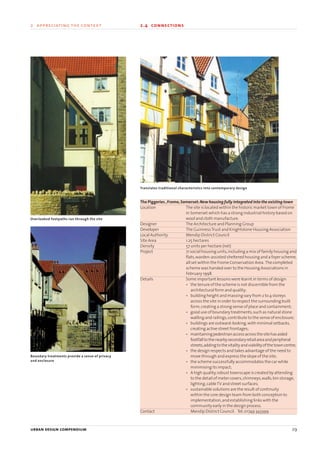
The Piggeries ,Frome,Somerset:New housing fully integrated into the existing town
Location The site is located within the historic market town of Frome
in Somerset which has a strong industrial history based on
wool and cloth manufacture.
Designer The Architecture and Planning Group
Developer The GuinnessTrust and Knightstone Housing Association
Local Authority Mendip District Council
Site Area 1.25 hectares
Density 57 units per hectare (net)
Project 71 social housing units,including a mix of family housing and
flats,warden-assisted sheltered housing and a foyer scheme,
all set within the Frome Conservation Area. The completed
scheme was handed over to the Housing Associations in
February 1998.
Details Some important lessons were learnt in terms of design:
• the tenure of the scheme is not discernible from the
architectural form and quality;
• building height and massing vary from 2 to 4 storeys
across the site in order to respect the surrounding built
form,creating a strong sense of place and containment;
• good use of boundary treatments,such as natural stone
walling and railings,contribute to the sense of enclosure;
• buildings are outward-looking,with minimal setbacks,
creating active street frontages;
• maintainingpedestrianaccessacrossthesitehasaided
footfalltothenearbysecondaryretailareaandperipheral
streets,addingtothevitalityandviabilityofthetowncentre;
• the design respects and takes advantage of the need to
move through and express the slope of the site;
• the scheme successfully accommodates the car while
minimising its impact;
• A high quality,robust townscape is created by attending
to the detail of meter covers,chimneys,walls,bin storage,
lighting,cableTV and street surfaces;
• sustainable solutions are the result of continuity
within the core design team from both conception to
implementation,and establishing links with the
community early in the design process.
Contact Mendip District Council. Tel:01749 343399
Boundary treatments provide a sense of privacy
and enclosure
Overlooked footpaths run through the site
Translates traditional characteristics into contemporary design
22375H urban design MASTER:22375H urban design MASTER 01/08/2007 10:23 Page 29
30 urban design compendium
2 appreciating the context 2.5 feasibility
The feasibility of a project,both in economic and practical terms,requires an
assessment of:
• community need;
• market supply and demand;
• funding sources;
• site capacity;
• land ownership,assembly and tenure;
• integration with surrounding context;
• construction costs;
• engineering constraints;
• local planning policy context.
The proposals will need to relate to their location and context,and will vary
with the type of project,whether infill,brownfield,urban extension or
regeneration.Appropriateness is the key;a highly urban solution will not be
appropriate on a suburban edge-of-town site,and vice versa.
An early assessment of the factors likely to affect a project’s feasibility will
form the basis for preliminary designs and testing.These will then require
continual iteration and re-evaluation.Table 2.5 provides an inventory of
considerations for undertaking an economic appraisal and feasibility review.
Table 2.5 Feasibility appraisal inventory
Subject area Considerations
Market • Existing feasibility studies
• Ownership and tenure
• Current development pressures
• Supply and demand (in relation to competition,
socio-economic profile,regional context etc.)
• Cost
• Funding sources (public/private/partnership)
• Grant regimes
Engineering • Existing services and utilities
• Existing obstructions (such as foundations and basements)
• Major constraints (such as culverts or gas mains)
• Ground conditions (such as contamination and subsidence)
• Geology
• Archeological investigation
• Drainage
• Man-made structures (such as bridges / roads)
• Requirements of other bodies (such as utilities)
Urban design studies for the Greenwich Peninsula have
had to address a wide range of engineering constraints
Sketches such as this can help evaluate urban capacity potential
22375H urban design MASTER:22375H urban design MASTER 01/08/2007 10:23 Page 30
urban design compendium 31
The vision is an amalgamation of hard physical and financial facts and
a series of aspirations.The synergy between these is crucial – to say:this is
what we want;this is how we will get there;this is who needs to be included
and take responsibility;this is where the money comes from;this is who
will champion the vision;and these are the mechanisms for delivery
(see section 6).
The contextual analysis is a springboard for shaping a vision as to what
can be achieved.It is easy to lose sight of the potential in facing up to the
numerous constraints,but regeneration projects that have been successfully
implemented provide sources of encouragement,and this Compendium
contains many examples.
Value can be created
A poor physical fabric or social problems may have stigmatised an area,but
history shows these attitudes can be changed.There are numerous
examples of‘problem places’becoming‘opportunity places’through a
quantum shift in their planning and marketing.
Constraints can be overcome
Creative proposals for brownfield land are often inhibited by the claim that
there is no market for what is proposed.As the transformation of Hulme in
Manchester has shown,with vision new markets and new futures can be
created and value added (see p.49).
Context is dynamic
Designs that are inherently flexible will enable future changes to be
accommodated - such as in household size and composition,lifestyles and
movement patterns.It is vital to conceive a masterplan as a framework that
will enable adaptation over time.The initial context appreciation stage has
two key outputs:
1 A SWOT analysis (Strengths,Weaknesses,Opportunities andThreats)
that provides a composite of the various‘layers’of consideration by
identifying existing strengths and weaknesses,opportunities for
improvement and threats to the project’s success (see 6.3).
2 Initial concept ideas and strategic options that sketch out the vision,
and build in flexibility to the project as it unfolds by ensuring that
the process is:
• participatory;
• capable of incremental implementation - balancing long-term
aspirations with short-term improvement or pump-priming
initiatives.St. James Road Urban Village, Gateshead:
defining the vision for the future regeneration
of a 50 hectare site
New ‘visions’ for proposed projects within
Devonport Urban Village
The use of computer modelling in the Granton Waterfront project has helped articulate the desired block structure and mix of uses
urban design compendium 31
2 appreciating the context 2.6 vision
22375H urban design MASTER:22375H urban design MASTER 01/08/2007 10:23 Page 31
3.1 The movement framework 3.2 Density,facilities and form 3.3 Energy efficiency 3.4 Landscape
3.5 Landmarks,vistas and focal points 3.6 Mixing uses 3.7 Blocks 3.8 Parcels and plots
03 CREATING THE
URBAN STRUCTURE
22375H urban design MASTER:22375H urban design MASTER 01/08/2007 10:23 Page 32
urban design compendium 33
What is meant by urban structure?
The term urban structure refers to the pattern or arrangement
of development blocks,streets,buildings,open space and
landscape which make up urban areas. It is the interrelationship
between all these elements,rather than their particular
characteristics that bond together to make a place.
Urban structure does not imply any particular kind of urbanism:
it applies equally to the centre and to the suburb,and everything
in between;and of course it applies equally to the city,the town
and the village.
Why urban structure is important
The urban structure provides the foundations for detailed design
of the constituent elements. It creates a coherent framework,
which forms the basis of the design of individual developments -
quite possibly by different actors - in order to achieve the
following:
• Integration
Connection and overlap with surrounding areas.
• Functional efficiency
So that individual elements (buildings,streets,
open space etc) work together as part of an efficient whole.
• Environmental harmony
Creating development forms that are energy efficient
and ecologically sensitive.
• A sense of place
Creating somewhere that is recognisably distinct but
simultaneously strengthens local identity.
• Commercial viability
Responding to the realities of market influence on
development mix and delivery.
22375H urban design MASTER:22375H urban design MASTER 01/08/2007 10:23 Page 33
Getting the movement right affects uses and activities,density,security and
the impact of the development on neighbouring places. The movement
framework concerns the structural aspects of movement,focusing on the
street and footpath networks. The individual activities and components of
a movement structure (walking,cycling,public transport etc) are addressed
in detail in Section 4.
A successful movement framework:
• provides the maximum choice for how people will make their journeys;
• takesfullaccount of thekindsofmovement adevelopment willgenerate;
• makes clear connections to existing routes and facilities.
Because every site is different there can be no standard formula. What suits a
large suburban site will be quite different from a pocket site in the inner city.
The movement framework should,wherever possible and practicable,
make it as easy and attractive to walk,cycle or take the bus,as it is to travel
by car. This means providing the right kinds of route to fit the journeys that
people want to make. The reason why one route is better than another
depends on countless factors,many of them quite intangible,hence route
assessment can never be an exact science. Predicting vehicle movements
is only one part of the exercise:how people experience their journey
(especially people on foot) is just as important.
34 urban design compendium
3 creating the urban structure 3.1 the movement framework
We should focus our efforts on improving routes to
bus stops, yet all too often these are unattractive
and intimidating.
High quality routes are over-looked, well lit
and attractively landscaped.
The movement framework clearly illustrates
the route network for pedestrians, cyclists, public
transport and other vehicles
Main Loop Road
Secondary Streets
Minor Streets
Key Footpath Routes
Promenade Cycleway
Possible Bus Stop
22375H urban design MASTER:22375H urban design MASTER 01/08/2007 10:23 Page 34
3.1.1 movement assessment
Undertake a movement assessment
This will form the basis for improving the existing network or creating a new
street pattern. Some of the factors to consider in relation to the various
modes of transportation (walking,cycling,bus,car,etc.) include:
• Safety
• Air quality
• Convenience of journey
• Speed
• Walking down and up kerbs
• Pedestrian crossings
• Pedestrian and cycle (Toucan) crossings
• Segregated path
• Quality of transport
• Overbridges
• Underpasses
• Severance
• Noise
• Pollution
• Visual amenity
• Variety in visual amenity
• Pavement congestion
• Road congestion
• Quality of pavements
• Quality of roads
• Cycle facilities
The quality of different routes can be rated to help decide which should be
developed or where improvements are needed.Redevelopment of an
existing site may provide opportunities to re-establish old routes that have
been destroyed or downgraded,and to improve movement through an area,
not just to and from the new site.
3.1.2 the walkable neighbourhood
Design for ease of walking
Local facilities bring residents together,reinforce community and discourage
car use.So the first component of a movement framework should be the
walking distances from facilities.The quality of the routes is important,
especially where there are obstructions such as busy roads or railway lines.
To give walking priority means putting the everyday experience of the street
first on the agenda.
People should be able to walk in 2-3 minutes (250 metres) to the post box or
telephone box:the newsagent’s should be within 5 minutes (400 metres).
There should be local shops,the bus stop,the health centre and perhaps a
primary school within a walking distance of (say) 10 minutes (800 metres).
urban design compendium 35
3 creating the urban structure 3.1 the movement framework
This can then be refined to reflect more accurately
existing routes and barriers to movement.
The first step is to define the walkable catchment area
to local facilities
A thorough movement assessment takes account of all
modes of transport
town centre
town centre
400
800
22375H urban design MASTER:22375H urban design MASTER 01/08/2007 10:23 Page 35
3.1.3 street network
Connect with the existing network
Direct,attractive connections between key facilities,avoiding dead ends,
help to create more convenient and comfortable places.An assessment of
how best the site can plug into the wider movement networks should aim to
provide the maximum number of direct connections to main streets
carrying through traffic.The more direct the links between main streets,the
greater the potential for mixed use (the links do not have to be vehicular).
Decide which links are most important to extend into the scheme,to provide
the basis for the internal movement structure.
Make or break boundaries
The linear elements that define the boundaries of a place - the edges - may
be used to define the limits of a development site or regeneration area.
Rivers,canals,parklands,busy roads or viaducts,may provide the definition
that contributes to a sense of place.
But sometimes punching through or spanning these edges will create an
enhanced spatial dynamic,by forging links with surrounding areas and
reducing severance.
36 urban design compendium
3 creating the urban structure 3.1 the movement framework
Consider how best the site can be connected
with nearby main routes and public
transport facilities
The typical cul-de-sac response creates an
introverted layout, which fails to integrate
with the surroundings
A more pedestrian-friendly aproach that
integrates with the surrounding community
links existing and proposed streets, and
provides direct links to bus stops
This street pattern then forms the basis
for perimeter blocks, which ensure that
buildings contribute positively to the
public realm
The Calls and Riverside, Leeds
Before: The river severs north and south
parts of the city
After: A new footbridge provides a direct
route to the city centre
A new link has been punched through the
railway viaduct – helping to stitch together
the city centre and riverfront
Principal routes
Bus stop
Internal streets
Key
22375H urban design MASTER:22375H urban design MASTER 01/08/2007 10:23 Page 36
The Calls and Riverside Planning Framework,Leeds:Breaking the barriers
Location Both sides of the River Aire immediately South East of Leeds’
central shopping area.
Master Plan Client Leeds Development Corporation
DesignTeam Master planner:Llewelyn-Davies
Project Planning framework for the regeneration of an area of
redundantVictorian warehousing adjacent to,but cut off
from,Leeds City Centre.
Details One of the central aims of the planning framework was to
break through the barrier imposed by the railway viaduct
and station,which served to bisect the riverside to the south
and the City Centre to the north.
A new physical link to the City Centre is now open and well
used.This connects the Corn Exchange building (now a
specialist shopping centre) to the riverside via a route
punched through a railway arch and a new pedestrian river
crossing.A lively urban quarter has developed,including
shops,a hotel,flats and offices.
Contact Leeds Development Agency. Tel:0113 247 7893
urban design compendium 37
3 creating the urban structure 3.1 the movement framework
Converted warehouses front onto the River Aire
High quality architecture has raised design
standards in the area
The planning framework
articulates a three-dimensional
vision for improvement of
the area
22375H urban design MASTER:22375H urban design MASTER 01/08/2007 10:23 Page 37
3.1.4 types of grid
The grid provides choice
The time-honoured way of achieving efficient connections is to create a grid,
which provides a simple structure,allowing access throughout the area. The
form may be orthogonal or more irregular;but its virtues are the same.The
grid also offers opportunities for traffic management,allowing restriction of
car access in some streets.
Gridspacingof80-100mprovidesanoptimumnetworkforpedestrianand
vehicularneedsinmostcircumstances. Thesizeofresultingdevelopmentblocks
hastobecheckedagainstproposedusesandbuildingtypes,andadjustedtosuit
(see3.7.2onblocksize).Incentralareaswithintensivepedestrianactivity,grid
spacingof50-70mprovidesanoptimumcirculationnetwork.
However the movement grid of this scale may not be appropriate for
structuring the overall urban form.For example,major urban blocks may be
over 200 metres or more in any dimension with minor cross streets and
footpaths through the blocks.Similarly,parallel street forms may be
appropriate,with minor cross routes.Issues of topography,orientation,
neighbouring uses and so on are all part of defining the appropriate grid
structure for a given development.
Birmingham Inner Ring Road:Loosening the collar
Project The Birmingham Inner Ring Road was completed in 1971,and
was regarded at that time as a classic improvement of its
kind. The aim was to remove trunk road traffic from the city
core by building a 3.5 mile road around the centre,punctuated by
roundabouts at seven junctions.In traffic management terms
something of the original aim has been fulfilled,but at the
expense of severing the urban fabric at its most vulnerable
points. The concrete collar which it has created has broken the
traditional links between the City Centre and neighbouring
areas. In particular,for people on foot it presents a hostile or
impenetrable barrier. The pedestrian subways at the
roundabouts are intimidating and humiliating,and have
blighted life and activity in the areas around the road.
Detail Since 1988 Birmingham City Council has adopted a policy of
remodelling the ring road,in order to:
• link the City Centre to neighbouring areas.
• enable City Centre activity to spread into those areas.
• create an improved pedestrian environment across
the city.In the way traffic is handled the emphasis has
shifted to the city’s middle ring road.The most
notable aspects of the scheme achieved so far are:
• lower Paradise Circus to create a new pedestrian link
to Centenary Square and the International
Convention Centre;
• re-create the Old Square as a pedestrian space on
the route from the City Centre to the Law Courts area;
• remodel Smallbrook Queensway,including
the removal of subways,to create a much improved
pedestrian link to the Chinese quarter of the city.
Contact Department of Planning & Architecture,Birmingham City
Council,Baskerville House,Broad Street,Birmingham B1 2NA
Tel: 0121 303 3157
38 urban design compendium
3 creating the urban structure 3.1 the movement framework
Portland, USA
Philadelphia, USA
London, West End
With part of the road lowered and a wide pedestrian
crossing provided, an area once severed now binds
together seamlessly
N
22375H urban design MASTER:22375H urban design MASTER 01/08/2007 10:23 Page 38
urban design compendium 39
3 creating the urban structure 3.2 mixing uses
Successful communities require a full range of local services and facilities,
including commercial,educational,health,spiritual and civic uses.These
need to be conveniently sited and connected to residential areas by safe and
comfortable routes.
Traditionally,towns have developed around crossroads,centres of activity or
stopping places,with the incremental growth of housing,retail,community
and employment uses around the original core.Yet despite the virtues of
mixed development (seeTable 3.1),in modern development it often remains
the exception,rather than the rule.
Table 3.1 The benefits of mixed development
• More convenient access to facilities
• Travel-to-work congestion is minimised
• Greater opportunities for social interaction
• Socially diverse communities
• Visual stimulation and delight of different buildings within
close proximity
• A greater feeling of safety,with‘eyes on streets’
• Greater energy efficiency and more efficient use of space and buildings
• More consumer choice of lifestyle,location and building type
• Urban vitality and street life
• Increased viability of urban facilities and support for small business
(such as corner shops)
A successful and sustainable local neighbourhood is a product of the
distances people have to walk to access daily facilities,the presence of a
sufficient range of such facilities to support their needs,and places and
spaces where a variety of activities can take place.
These are exemplified by the traditionalVictorian and Edwardian suburbs
which were built on the assumption that most movement would be
pedestrian.Other travel needs were serviced by a suburban rail line - the
station providing the focus of retail,commercial and civic activity.
Such spatial and use patterns are often difficult to replicate in modern
development due to current transport planning regimes,the dispersal
of movement patterns facilitated by the car and the trend towards ever-
larger retail,educational or healthcare buildings in order to achieve
efficiencies of scale.
A more vibrant and sustainable form results from
blurring the distinction between uses and designing
places that make walking to the local centre, and bus
stop or railway station, as convenient and comfortable
as possible
Business park
Parkland
Low density
residential area
Medium density
residential area
Open
space
Medium
density
housing
Low
density
housing
Light
industrial
area
industrial
Business
park
Local centre
Mixed
workspaces
predominate
Mixed
workspaces
predominate
Residential
hinterland
Residential
hinterland
Transition zone
Mainly heavy
industry
Local centre
Uses are still being zoned and roads designed as
strategic routes at the expense of the creation of more
local relationships based on walking and cycling.
In designing new places, what role is the centre to have
when all the potential ‘mixed use elements’ are sucked
to the edge?
22375H urban design MASTER:22375H urban design MASTER 01/08/2007 10:23 Page 39
Often the planning system does not help.To illustrate,if we take a typical
large site,land uses may include housing,a primary school,shops,offices
and some industry.Planning generally zones these uses and gives them
relatively fixed boundaries before any serious design work is undertaken. On
occasion,sites are carved into development parcels around a rudimentary
road system without a clear urban design structure in place. At this stage,it
is not unknown for densities to be decided upon,as well as other fixed
requirements - open space provision,for example. This approach frequently
involves routing the main road round the site rather than across it and
locating the traffic generating uses such as retail and employment areas
close to entrance junctions and along the main road. The road is used as a
boundary to segregate uses.Such attempts to create a sense of place around
a focal point often fail because the very uses that generate activity are on the
edge of the site or beyond,in a nearby business park or out-of-town centre,
and tend to be internalised in‘big boxes’.
This tendency can be reversed by promoting diversity in terms of:
• Development forms;
• Land use;
• Density;
• Tenure;
• Market segments.
3.2.1 the neighbourhood unit
Build walkable neighbourhoods
Mixed use development can best be promoted by using the distance most
people will walk to daily facilities,the corner shop or the bus stop as a
starting point.
The neighbourhood unit can provide a useful organising device - but only
when it is overlaid on an integrated movement framework and conceived as
a piece of town or city whose activities and forms overlap.This is to move
away from large-scale projects envisaged or described as neighbourhoods,
but designed as disconnected enclaves.It is also to move away from estates
and layouts - terms which in themselves serve to emphasise single use
and segregation.
A widely used benchmark is for mixed development neighbourhoods to
cover a 400m radius,equating to about five minutes walk.This translates
into 50 hectares.
3.2.2 character areas
A patchwork of different activities
In many towns and cities,there is scope for strengthening existing
neighbourhoods where identity is based on a particular activity or mix,
(a market place or college campus for example),or devising new areas of
special character.Such‘character areas’can reinforce local identity and serve
as a marketing tool to raise the profile of a particular place,as in the case of
Birmingham’s Jewellery Quarter.These may relate to predominant uses,
focal buildings,historic associations or ethnic composition,such as a
Chinatown.
40 urban design compendium
3 creating the urban structure 3.2 mixing uses
New
Town Gun
Quarter
Aston
Triangle
Jewellery
Quarter
St
Pauls
Lady-
wood
Convention
Quarter
City core
Curzon
Street
Chinese
Markets
Quarter
Holliday
Street
Lee Bank
Digbeth
Highgate
Legal
Quarter
400m
400m
400m
400m
400m
a) Nodal neighbourhood b) Street neighbourhood
c) Neighbourhood
adjacent to main road
d) Waterfront
neighbourhood
e) Neighbourhood
at a motorway
f) Neighbourhood
across a slope
g) Town centre with railway station
surrounded by neighbourhood clusters
h) Town centre with outlying neighbourhood clusters
Birmingham urban design strategy:
neighbourhood identities
The heritage of the Jewellery Quarter is being
used to underpin proposals to enhance this
urban village (source: EDAW)
400m
400m
400m
400m
400m
22375H urban design MASTER:22375H urban design MASTER 01/08/2007 10:23 Page 40
Identify whether the project relates to a particular character area.If so,
consider the implications for use mix,building form and design of open
spaces.Can new themes be added or particular existing attributes
strengthened further?
3.2.3 compatible uses
Maximise synergy, minimise conflict
Diversity inevitably brings some conflict.Existing places demonstrate that
most activities can live harmoniously side-by-side,with this conflict
designed out at the detailed level.Indeed,it is a positive virtue of many well-
established places,where a whole mêlée of sights,sounds and smells gives
uniqueness and character.But different uses have different needs - not all
mixes are appropriate - no-one wants a car breaker’s yard backing onto a
park - and some uses are better located in single use blocks.
In considering the widest possible mix of uses that can be introduced to add
vitality an economic feasibility study should be undertaken to check viability.
This should be undertaken in conjunction with an evaluation of the relative
compatibility between the proposed uses and their existing neighbours,and
then each use positioned to promote compatibility and avoid conflict.High
traffic-generators such as distribution warehousing complexes,for instance,
are best located close to motorway junctions and railheads.
Combine primary activities
Combining the primary activities of living and working supports a greater
variety of secondary facilities (whether commercial,entertainment,leisure
or community-based).Grouping the main elements of the palette of uses to
be accommodated will help to make a place.
Within core areas,lessons can be learnt from the design of shopping centres,
where uses are positioned to concentrate pedestrian flows by spacing
anchor stores a maximum of about 250m apart.
3.2.4 mixed forms, uses and users
Sprinkle housing types and tenures
Both the scale of the centre and the mix of uses it contains will depend on
where the scheme sits in relation to the urban hierarchy.This of course varies
from place to place,but many sites will have a layering – centre,transition
zone and outer edge.Mixing tenures promotes social diversity and it is
therefore important to spread different building types and tenures across
this range.‘Pepper-potting’different tenures throughout an area ensures
that a variety of housing types and ownership patterns are sprinkled,rather
than clustered into exclusive enclaves.As projects such as Coin Street on
London’s South Bank have demonstrated,financial planning mechanisms
need to be considered at an early stage,based on authoratative advice.
Physical planning and financial planning should proceed hand in hand.
urban design compendium 41
3 creating the urban structure 3.2 mixing uses
Gloucester Green in Oxford provides a lively and
attractive mix of flats above shops and restaurants
‘Pepper–potting’ tenures in the redevelopment of the
Trowbridge Estate, Hackney (PRP Architects)
Tenure
Shared
Covenant
Sale
Mixed
22375H urban design MASTER:22375H urban design MASTER 01/08/2007 10:23 Page 41
3.2.5 centres
Focus centres on public transport nodes
Highest concentrations of activity (particularly the retail core) emerge
naturally along principal routes or points of convergence - along high streets,
at crossroads and so on.These centres vary in size depending on location,the
nature of the street network,overall densities and size of catchment.
Mixed-use centres are best located at crossroads and along main movement
routes,within walking distance of homes.This strengthens their identity,
provides passing trade and enables bus stops and/or railway stations to be
fully integrated.For small sites,bear in mind how the site is connected to
existing local centres.
Inject housing into the mix
Centres that have been a victim of postwar zoning demonstrate how vitality
and viability are lost where housing is not part of the mix.Injecting housing
into the mix wherever possible enables activity to be stretched beyond
daytime office and shopping hours.
The ability to introduce non-residential uses into housing areas varies
tremendously between the centre and edge of a settlement.To create a
strong community focus,a shop,bus stop and primary school will usually be
considered a bare minimum.In large housing schemes that cannot be
expected to attract many non-residential uses,consider the‘centre’as the
core residential area within which the local shops,commercial use and
amenities will sit.
Emphasise the civic
Public services and amenities support residents and workers,and provide
focal elements of an urban structure that help to encourage a strong sense
of community and identity.Nurseries,libraries,community centres,police
and fire stations and government offices are best placed at central points in
highlyvisiblelocations.Publicsquarescanbeusedtoemphasisetheircivicstatus.
Smithfield Buildings,Manchester:Mixing it up
Location Tib Street in the Northern Quarter of the City Centre
Designer Stephenson Bell Architects
Developer Urban Splash (Developments) Ltd
Local Authority Manchester City Council
Floor Area 13,424 m2
former department store
Project The creation of 81 loft apartments,21 ground floor shops
and a basement gym
Details Until its decline in the 1950s,Smithfield Buildings housed
one of the city’s most famous department stores - Affleck
and Brown,the“Harrods of the North”.Throughout the 1980s
the building stood empty,but was located within an area
targeted for regeneration by the City Council.With design
ingenuity and flair it has now been redeveloped into award-
winning,highly desirable,loft apartments with shops,cafes
and a nightclub below.In design terms this has been
achieved by retaining the atrium to provide daylight into the
centre of the block,and skirting this with internal access
galleries.The dramatic loft layouts harness to great
effect the potential for new forms of urban living.
Contact Urban Splash. Tel:0161 237 9499
42 urban design compendium
3 creating the urban structure 3.2 mixing uses
A variety of active uses
line the ground floor
A footbridge links to the
adjacent multi-storey car
park
Public transport orientated development ensures that a
mixed use community has a railway station or bus stop
within walking distance at its heart
Positioning local centres away from main routes
deprives them of life and passing trade
The answer is to create pedestrian and public
transport–orientated centres at key focal points
The existing
superstructure has
been retained
An atrium brings light to
the interior
UrbanSplash
22375H urban design MASTER:22375H urban design MASTER 01/08/2007 10:23 Page 42
3.2.6 edges
Absorb the ‘big-box’ into the mix
Sustainable development requires that:
• out-of-town development,often mono-functional in nature,such as
industrial,office and retail parks,is curtailed;
• these elements are brought back into urban centres,to become part
of the urban mix.
This has fundamental implications in terms of form,density and parking,
particularly how to accommodate‘big-boxes’(whether multiplexes,
superstores or retail warehouses) - as developers will often be reluctant to
change their standard approaches.
It is important to establish that the provision of such facilities must be
appropriate to the needs of the locality,and must not impose socio-
economic costs on the community in terms of traffic generation,visual
blight and undermining established centres.A preferred approach is to:
• absorb‘big-boxes’into the transition area on the edge of the retail core.
The presence of larger development blocks in these locations can
provide sufficient land to wrap the main perimeter of the box with a
skin of smaller buildings - concealing its bulk and creating active
frontage (see 5.2.1).Siting within the walkable catchment
from a public transport node (see 3.1.2) also encourages more
sustainable customer transport patterns;
• select‘cul-de-sac locations’where at least one site edge requires no
frontage (such as adjacent to a railway line).This lessens the amount
of exposed blank walls and servicing.
Wrap and cap the ‘big-box’
Large stores and other large‘big-box’units that are often stand-alone,with
exposed‘dead’frontages,create particular problems for active and attractive
streets (see 5.2.1).However,such building types can be modified to become
compatible with fine-grained urban settings by mixing horizontally and/or
vertically with other uses,which may involve:
• wrapping the perimeter on the street faces with smaller units
(such as Sainsbury’s supermarket,Clapham High Street);
• building other uses on the air space above the box
(Tesco’s supermarkets,Sheffield and Earls Court);
• incorporating a well designed upper façade for roof top parking
(such as Safeway’s supermarket in Fulham);
• externalising more active uses (such as cafés and boutiques)
and increasing their‘transparency’to the street.
urban design compendium 43
3 creating the urban structure 3.2 mixing uses
Big box sheds surrounded by parking: potential
active frontage is projected into the car park, rear
elevations exposed and the streetscape undermined
By turning the sales floor 900
and inserting
the building into a perimeter block, access is
provided from both sides but active street
frontage is ensured
Wrap big boxes with smaller units to create
active frontage
Ocean Village cinema, Southampton
Furniture showroom, Newbury
(Architect: Sutton Griffin & Morgan)
22375H urban design MASTER:22375H urban design MASTER 01/08/2007 10:23 Page 43
Bring dead edges to life
Mono-functional commercial developments (industrial,business,retail,
leisure,office or science parks),are clusters of low-density facilities that in
recent years have formed drive-in estates cut-off from their surroundings.
They remain one of the most problematic challenges for urban designers
concerned with creating integrated mixed developments.
Clustering low density facilities in marginal locations is only justifiable where
noise or pollution emissions prevent closer integration with residential areas
and low grade urban land (such as adjacent to a railway) can be utilised.
The preferred approach is to locate such employment and commercial uses
in such a way that they link to nearby centres with access to public transport,
are accessible off main routes and are also in walking distance of as much
housing as possible.If‘big-boxes’or‘sheds’are unavoidable,then ensure
they are accommodated within a perimeter block structure,with a public
frontage and high quality landscaping.Allow for future retrofitting and
densification,especially of their often excessive parking areas (see 3.3.4).
44 urban design compendium
3 creating the urban structure 3.2 mixing uses
The development of Broughton Atterbury in
Milton Keynes is intended to become a model
high quality urban extension
Broughton Atterbury,Milton Keynes:Extending the City
Location North eastern Milton Keynes
Promoter English Partnerships
DesignTeam Facilitators:English Partnerships,The Prince’s Foundation
Master Planners:EDAW
Development Briefing:English Partnerships
Site Area 55 hectares
Density 750 dwellings @ 34 dwellings per hectare average.
27,525 m2
commercial @ 40% site cover
Project Framework plan for a development located at the edge of the
new city of Milton Keynes which is being promoted as an
urban village and includes the existing hamlet of Broughton.
The development area includes landfill on former sand pits
and will comprise:
• 750 dwellings,including home working
• 27,500m2
commercial/employment/workshops
• First School
• Linear Park
• Recreation and social facilities
Details Broughton Atterbury was selected to explore the potential
for the development of a new urban village in Milton Keynes.
The Prince’s Foundation assistedEnglishPartnershipsin
pulling togetherstakeholdersincludinglocal residents,
community representatives and officials,business people,
police and special interest groups. A Planning for Real
weekend attended by 120 people resulted in a vision and
brief for consultants to prepare a master plan based on
urban village principles of mixed uses,quality urban design
and sustainability.The master plan formed
advanced infrastructure works and the preparation of
individual site development briefs which incorporated
pioneering requirements on sustainability and energy
conservation. The first commercial and residential
developers have been selected by assessment panels -
including English Partnerships,Milton Keynes Council,the
Prince’s Foundation,National Energy Foundation,local
residents,and the Building Research Establishment (BRE) -
and meet the exacting design,sustainability and financial
criteria set. In addition,the proposals will assist the BRE in
establishing Building Research Establishment Environmental
Assessment Method (BREEAM) Estates,a new standard for
assessing the sustainability of site development.
Contact Dan Myers,English Partnerships. Tel:01908 353 901
22375H urban design MASTER:22375H urban design MASTER 01/08/2007 10:23 Page 44
3.2.7 transition zones
A rich mix in transition
The transition zone between centre and edge is fertile land for mixing to
occur,and can vary enormously in character.These are the hotch-potch areas
that bridge the commercial core and the residential hinterland.It is within
these zones that the most dynamic mix occurs,with shops,workspaces,
storage yards,and houses existing side-by-side.Land values enable some of
these lower density uses to thrive and provide the most scope for
encouraging live-work,speciality retailing,artist and cultural quarters,for
instance.In large schemes,transition zones can be used to buffer homes and
other noise-sensitive uses from activity sources.However,night-time uses
(pubs,clubs and restaurants) can also work well here.If positioned away
from predominantly residential areas they can also feed off one another
when they are clustered.
Schools are also often best located in the transition zone between the higher
density residential areas and local centres,where they are as close as
possible to the majority of children,and where they can be introduced
without cutting off pedestrian access to the centre.
Laganside Masterplan,Belfast:Reconnecting the centre and riverfront
Location On the side of the River Lagan to the east of the city.
DesignTeam Architects:Birds Portchmouth Russum
Transport Engineer:Ove Arup and Partners
Property Consultant:JamesW.Burgess
Cost Management Consultant:Gardiner &Theobold
Client Laganside Corporation
Project To create a new mixed-use city block,extending beneath the
Cross Harbour Bridges and linking the city centre with the
banks of the River Lagan.
Details The Masterplan provided the basis for the creation of three
new major public spaces linked by a riverside walk and
flanked with a mix of activities.Implementation of this
concept is now well advanced,with Corporation Square
enlarged and reconfigured to play a more civic role,with an
historic ship planned to be berthed in dry dock at its centre.
Custom House and Laganbank squares also address the river,
together with new buildings containingYMCA/student
housing,small businesses,retail units,cafes,bars,nightclubs
and hotels to add further life and vitality.Seven new
apartment blocks are proposed to provide a built edge to the
riverfront,together with a café,crèche and sports/recreation
facilities.Workshops,showrooms,retail units and a multi-
storey car park are to be accommodated beneath
the bridges.
Contact Laganside Corporation. Tel:028 9032 8507
urban design compendium 45
3 creating the urban structure 3.2 mixing uses
Brighton's North Laines provide a mixture of
shops, workspaces, residential development, cafes
and theatres.
22375H urban design MASTER:22375H urban design MASTER 01/08/2007 10:23 Page 45
Urban design-compendium manual

More Related Content

What's hot

Urban design criteria the holistic approach for design assessment
Urban design criteria the holistic approach for design assessmentUrban design criteria the holistic approach for design assessment
Urban design criteria the holistic approach for design assessment
Nik Latogan
 
Tissue Analysis - Urban Design - Architecture
Tissue Analysis - Urban Design - ArchitectureTissue Analysis - Urban Design - Architecture
Tissue Analysis - Urban Design - Architecture
Sabarathinam Kuppan
 
Urban Redevelopment
Urban RedevelopmentUrban Redevelopment
Urban Redevelopment
Md. Abdul Kader
 
Case Study: Sustainable Mixed-Use Development in Historic Urban Areas
Case Study: Sustainable Mixed-Use Development in Historic Urban AreasCase Study: Sustainable Mixed-Use Development in Historic Urban Areas
Case Study: Sustainable Mixed-Use Development in Historic Urban Areas
Sustainable Performance Institute
 
Urban planning concept,principles and elementes
Urban planning  concept,principles and elementes Urban planning  concept,principles and elementes
Urban planning concept,principles and elementes
TeshagerMengesha
 
Urban morphology, elements of urban design
Urban morphology, elements of urban designUrban morphology, elements of urban design
Urban morphology, elements of urban design
Abdul Rab
 
Architectural Design Project Site Analysis
Architectural Design Project Site AnalysisArchitectural Design Project Site Analysis
Architectural Design Project Site Analysis
jernjack
 
Radiant city concept of le corbusier
Radiant city concept of le corbusierRadiant city concept of le corbusier
Radiant city concept of le corbusier
Kriti Chauhan
 
DOXIADIS (HUMAN SETTLEMENT AND PLANING)
DOXIADIS (HUMAN SETTLEMENT AND PLANING)DOXIADIS (HUMAN SETTLEMENT AND PLANING)
DOXIADIS (HUMAN SETTLEMENT AND PLANING)
ARCHITECTURE SCHOOL
 
Affordable housing programming for architecture - thesis project
Affordable housing programming for architecture - thesis projectAffordable housing programming for architecture - thesis project
Affordable housing programming for architecture - thesis project
GhassanAlhammadi1
 
urban design
urban design urban design
urban design
Indrajit Koner
 
Masters Thesis Report _ Skyscraper _ High rise Mixed use Development
Masters Thesis Report _ Skyscraper _ High rise Mixed use DevelopmentMasters Thesis Report _ Skyscraper _ High rise Mixed use Development
Masters Thesis Report _ Skyscraper _ High rise Mixed use Development
Ar. M. Senthil [ senthilmani ]
 
Compact City
Compact CityCompact City
Design Studio 5: Site Analysis Presentation Boards
Design Studio 5: Site Analysis Presentation BoardsDesign Studio 5: Site Analysis Presentation Boards
Design Studio 5: Site Analysis Presentation Boards
Ivy Yee
 
Presentation of urban design
Presentation of urban designPresentation of urban design
Presentation of urban design
vermaharsha
 
2.1_URBAN DESIGN PRINCIPLES, PATTERN AND SHAPE.pdf
2.1_URBAN DESIGN PRINCIPLES, PATTERN AND SHAPE.pdf2.1_URBAN DESIGN PRINCIPLES, PATTERN AND SHAPE.pdf
2.1_URBAN DESIGN PRINCIPLES, PATTERN AND SHAPE.pdf
JaelaurenceCDiosana
 
A Slum Redevelopment Project
A Slum Redevelopment ProjectA Slum Redevelopment Project
Architectural conservation
Architectural conservationArchitectural conservation
Architectural conservation
Aditi Koshley
 
EKISTICS
EKISTICSEKISTICS
Case Study of Building Services in Multi-Purpose Buildings involving Public Use
Case Study of Building Services in Multi-Purpose Buildings involving Public UseCase Study of Building Services in Multi-Purpose Buildings involving Public Use
Case Study of Building Services in Multi-Purpose Buildings involving Public Use
Carmen Chan
 

What's hot (20)

Urban design criteria the holistic approach for design assessment
Urban design criteria the holistic approach for design assessmentUrban design criteria the holistic approach for design assessment
Urban design criteria the holistic approach for design assessment
 
Tissue Analysis - Urban Design - Architecture
Tissue Analysis - Urban Design - ArchitectureTissue Analysis - Urban Design - Architecture
Tissue Analysis - Urban Design - Architecture
 
Urban Redevelopment
Urban RedevelopmentUrban Redevelopment
Urban Redevelopment
 
Case Study: Sustainable Mixed-Use Development in Historic Urban Areas
Case Study: Sustainable Mixed-Use Development in Historic Urban AreasCase Study: Sustainable Mixed-Use Development in Historic Urban Areas
Case Study: Sustainable Mixed-Use Development in Historic Urban Areas
 
Urban planning concept,principles and elementes
Urban planning  concept,principles and elementes Urban planning  concept,principles and elementes
Urban planning concept,principles and elementes
 
Urban morphology, elements of urban design
Urban morphology, elements of urban designUrban morphology, elements of urban design
Urban morphology, elements of urban design
 
Architectural Design Project Site Analysis
Architectural Design Project Site AnalysisArchitectural Design Project Site Analysis
Architectural Design Project Site Analysis
 
Radiant city concept of le corbusier
Radiant city concept of le corbusierRadiant city concept of le corbusier
Radiant city concept of le corbusier
 
DOXIADIS (HUMAN SETTLEMENT AND PLANING)
DOXIADIS (HUMAN SETTLEMENT AND PLANING)DOXIADIS (HUMAN SETTLEMENT AND PLANING)
DOXIADIS (HUMAN SETTLEMENT AND PLANING)
 
Affordable housing programming for architecture - thesis project
Affordable housing programming for architecture - thesis projectAffordable housing programming for architecture - thesis project
Affordable housing programming for architecture - thesis project
 
urban design
urban design urban design
urban design
 
Masters Thesis Report _ Skyscraper _ High rise Mixed use Development
Masters Thesis Report _ Skyscraper _ High rise Mixed use DevelopmentMasters Thesis Report _ Skyscraper _ High rise Mixed use Development
Masters Thesis Report _ Skyscraper _ High rise Mixed use Development
 
Compact City
Compact CityCompact City
Compact City
 
Design Studio 5: Site Analysis Presentation Boards
Design Studio 5: Site Analysis Presentation BoardsDesign Studio 5: Site Analysis Presentation Boards
Design Studio 5: Site Analysis Presentation Boards
 
Presentation of urban design
Presentation of urban designPresentation of urban design
Presentation of urban design
 
2.1_URBAN DESIGN PRINCIPLES, PATTERN AND SHAPE.pdf
2.1_URBAN DESIGN PRINCIPLES, PATTERN AND SHAPE.pdf2.1_URBAN DESIGN PRINCIPLES, PATTERN AND SHAPE.pdf
2.1_URBAN DESIGN PRINCIPLES, PATTERN AND SHAPE.pdf
 
A Slum Redevelopment Project
A Slum Redevelopment ProjectA Slum Redevelopment Project
A Slum Redevelopment Project
 
Architectural conservation
Architectural conservationArchitectural conservation
Architectural conservation
 
EKISTICS
EKISTICSEKISTICS
EKISTICS
 
Case Study of Building Services in Multi-Purpose Buildings involving Public Use
Case Study of Building Services in Multi-Purpose Buildings involving Public UseCase Study of Building Services in Multi-Purpose Buildings involving Public Use
Case Study of Building Services in Multi-Purpose Buildings involving Public Use
 

Viewers also liked

Mainstream concepts in urban design_Barrie Shelton
Mainstream concepts in urban design_Barrie SheltonMainstream concepts in urban design_Barrie Shelton
Mainstream concepts in urban design_Barrie Sheltonjpblancomoya
 
Urban Form and Design - Urban Sustainability & Resilience
Urban Form and Design - Urban Sustainability & ResilienceUrban Form and Design - Urban Sustainability & Resilience
Urban Form and Design - Urban Sustainability & ResilienceAnuradha Mukherji
 
History, Theories, Principles of Urban and Regional Planning
History, Theories, Principles of Urban and Regional PlanningHistory, Theories, Principles of Urban and Regional Planning
History, Theories, Principles of Urban and Regional Planning
EnP Ragene Andrea Palma
 
Theories and Concepts of town planning
Theories and Concepts of town planningTheories and Concepts of town planning
Theories and Concepts of town planningSrishti Mehta
 
Urban Planning theories and models
Urban Planning theories and modelsUrban Planning theories and models
Urban Planning theories and models
Geofrey Yator
 
Somethings unique in sabang
Somethings unique in sabangSomethings unique in sabang
Somethings unique in sabangDedy Ruzwardy
 
Summer school in Architecture and Urban Design "Sochi peshkom" Midterm Presen...
Summer school in Architecture and Urban Design "Sochi peshkom" Midterm Presen...Summer school in Architecture and Urban Design "Sochi peshkom" Midterm Presen...
Summer school in Architecture and Urban Design "Sochi peshkom" Midterm Presen...Sochi - peshkom
 
landscapes of love, sharing and co creation in urban spaces, a case of ahmeda...
landscapes of love, sharing and co creation in urban spaces, a case of ahmeda...landscapes of love, sharing and co creation in urban spaces, a case of ahmeda...
landscapes of love, sharing and co creation in urban spaces, a case of ahmeda...
Dr Anil Gupta
 
Augmented reality for architectural visualisation
Augmented reality for architectural visualisationAugmented reality for architectural visualisation
Augmented reality for architectural visualisationSochi - peshkom
 
Urban spaces in Spain
Urban spaces in SpainUrban spaces in Spain
Urban spaces in Spain
Salvador Sanchez
 
pembangunan berkelanjutan: Prof. Emil Salim
pembangunan berkelanjutan: Prof. Emil Salimpembangunan berkelanjutan: Prof. Emil Salim
pembangunan berkelanjutan: Prof. Emil SalimDedy Ruzwardy
 
Tactical Urbanism, Lecture by Arvind Ramachandran, 7 July 2013
Tactical Urbanism, Lecture by Arvind Ramachandran, 7 July 2013Tactical Urbanism, Lecture by Arvind Ramachandran, 7 July 2013
Tactical Urbanism, Lecture by Arvind Ramachandran, 7 July 2013Sochi - peshkom
 
Design with policies, lecture by Petar Vranic, 4 July 2013
Design with policies, lecture by Petar Vranic, 4 July 2013Design with policies, lecture by Petar Vranic, 4 July 2013
Design with policies, lecture by Petar Vranic, 4 July 2013Sochi - peshkom
 
Economic Evaluation of Urban Regeneration
Economic Evaluation of Urban RegenerationEconomic Evaluation of Urban Regeneration
Economic Evaluation of Urban Regeneration
VIVA_EAST
 
Arc251 02 the-scope-of-urban-design
Arc251 02 the-scope-of-urban-designArc251 02 the-scope-of-urban-design
Arc251 02 the-scope-of-urban-design
Shivani Gupta
 
Responsive Environments - Critical report
Responsive Environments - Critical reportResponsive Environments - Critical report
Responsive Environments - Critical reportMaria Gomez
 
The Uses of Sidewalks:Contact, Jane Jacobs (1961)
The Uses of Sidewalks:Contact, Jane Jacobs (1961)The Uses of Sidewalks:Contact, Jane Jacobs (1961)
The Uses of Sidewalks:Contact, Jane Jacobs (1961)
Natalva001
 
The social life of small urban spaces
The social life of small urban spacesThe social life of small urban spaces
The social life of small urban spaces
mohd danish
 
Bold City: A Bold Vision for Cape Town's Voortrekker Corridor
Bold City: A Bold Vision for Cape Town's Voortrekker CorridorBold City: A Bold Vision for Cape Town's Voortrekker Corridor
Bold City: A Bold Vision for Cape Town's Voortrekker Corridor
futurecapetown
 

Viewers also liked (20)

Mainstream concepts in urban design_Barrie Shelton
Mainstream concepts in urban design_Barrie SheltonMainstream concepts in urban design_Barrie Shelton
Mainstream concepts in urban design_Barrie Shelton
 
Urban Form and Design - Urban Sustainability & Resilience
Urban Form and Design - Urban Sustainability & ResilienceUrban Form and Design - Urban Sustainability & Resilience
Urban Form and Design - Urban Sustainability & Resilience
 
History, Theories, Principles of Urban and Regional Planning
History, Theories, Principles of Urban and Regional PlanningHistory, Theories, Principles of Urban and Regional Planning
History, Theories, Principles of Urban and Regional Planning
 
Theories and Concepts of town planning
Theories and Concepts of town planningTheories and Concepts of town planning
Theories and Concepts of town planning
 
Urban Planning theories and models
Urban Planning theories and modelsUrban Planning theories and models
Urban Planning theories and models
 
Somethings unique in sabang
Somethings unique in sabangSomethings unique in sabang
Somethings unique in sabang
 
Summer school in Architecture and Urban Design "Sochi peshkom" Midterm Presen...
Summer school in Architecture and Urban Design "Sochi peshkom" Midterm Presen...Summer school in Architecture and Urban Design "Sochi peshkom" Midterm Presen...
Summer school in Architecture and Urban Design "Sochi peshkom" Midterm Presen...
 
landscapes of love, sharing and co creation in urban spaces, a case of ahmeda...
landscapes of love, sharing and co creation in urban spaces, a case of ahmeda...landscapes of love, sharing and co creation in urban spaces, a case of ahmeda...
landscapes of love, sharing and co creation in urban spaces, a case of ahmeda...
 
Urban drifts of sochi
Urban drifts of sochiUrban drifts of sochi
Urban drifts of sochi
 
Augmented reality for architectural visualisation
Augmented reality for architectural visualisationAugmented reality for architectural visualisation
Augmented reality for architectural visualisation
 
Urban spaces in Spain
Urban spaces in SpainUrban spaces in Spain
Urban spaces in Spain
 
pembangunan berkelanjutan: Prof. Emil Salim
pembangunan berkelanjutan: Prof. Emil Salimpembangunan berkelanjutan: Prof. Emil Salim
pembangunan berkelanjutan: Prof. Emil Salim
 
Tactical Urbanism, Lecture by Arvind Ramachandran, 7 July 2013
Tactical Urbanism, Lecture by Arvind Ramachandran, 7 July 2013Tactical Urbanism, Lecture by Arvind Ramachandran, 7 July 2013
Tactical Urbanism, Lecture by Arvind Ramachandran, 7 July 2013
 
Design with policies, lecture by Petar Vranic, 4 July 2013
Design with policies, lecture by Petar Vranic, 4 July 2013Design with policies, lecture by Petar Vranic, 4 July 2013
Design with policies, lecture by Petar Vranic, 4 July 2013
 
Economic Evaluation of Urban Regeneration
Economic Evaluation of Urban RegenerationEconomic Evaluation of Urban Regeneration
Economic Evaluation of Urban Regeneration
 
Arc251 02 the-scope-of-urban-design
Arc251 02 the-scope-of-urban-designArc251 02 the-scope-of-urban-design
Arc251 02 the-scope-of-urban-design
 
Responsive Environments - Critical report
Responsive Environments - Critical reportResponsive Environments - Critical report
Responsive Environments - Critical report
 
The Uses of Sidewalks:Contact, Jane Jacobs (1961)
The Uses of Sidewalks:Contact, Jane Jacobs (1961)The Uses of Sidewalks:Contact, Jane Jacobs (1961)
The Uses of Sidewalks:Contact, Jane Jacobs (1961)
 
The social life of small urban spaces
The social life of small urban spacesThe social life of small urban spaces
The social life of small urban spaces
 
Bold City: A Bold Vision for Cape Town's Voortrekker Corridor
Bold City: A Bold Vision for Cape Town's Voortrekker CorridorBold City: A Bold Vision for Cape Town's Voortrekker Corridor
Bold City: A Bold Vision for Cape Town's Voortrekker Corridor
 

Similar to Urban design-compendium manual

Delivering quality places urban-design-compendium-2
Delivering quality places urban-design-compendium-2Delivering quality places urban-design-compendium-2
Delivering quality places urban-design-compendium-2
Harold Woods LEED AP, RIBA
 
North Lincolnshire Residential Design Guide
North Lincolnshire Residential Design GuideNorth Lincolnshire Residential Design Guide
North Lincolnshire Residential Design GuideGraeme Moore
 
Nova Architecture
Nova ArchitectureNova Architecture
Nova Architecture
RafaelAponte19
 
Nova architecture
Nova architectureNova architecture
Nova architecture
RafaelAponte19
 
GRESB Sustainable Urban Areas and Infrastructure
GRESB Sustainable Urban Areas and InfrastructureGRESB Sustainable Urban Areas and Infrastructure
GRESB Sustainable Urban Areas and Infrastructure
GRESB
 
BPD Project-converted.pdf
BPD Project-converted.pdfBPD Project-converted.pdf
BPD Project-converted.pdf
PiyushShahane3
 
Amm 144654-10-152-1 scott point estate guide
Amm 144654-10-152-1 scott point estate guideAmm 144654-10-152-1 scott point estate guide
Amm 144654-10-152-1 scott point estate guide
Michael Zhang
 
기스본 도심상업개발을 위한 도시 디자인 가이드북
기스본 도심상업개발을 위한 도시 디자인 가이드북기스본 도심상업개발을 위한 도시 디자인 가이드북
기스본 도심상업개발을 위한 도시 디자인 가이드북
Seongwon Kim
 
Urban design toolkit
Urban design toolkitUrban design toolkit
Urban design toolkit
Nikita Londhe
 
Lucas Navarro, MCH2023, Argentina
Lucas Navarro, MCH2023, ArgentinaLucas Navarro, MCH2023, Argentina
Lucas Navarro, MCH2023, Argentina
MCH
 
Architectural Design 1 Lectures by Dr. Yasser Mahgoub - Process
Architectural Design 1 Lectures by Dr. Yasser Mahgoub - ProcessArchitectural Design 1 Lectures by Dr. Yasser Mahgoub - Process
Architectural Design 1 Lectures by Dr. Yasser Mahgoub - Process
Galala University
 
Urban renewal
Urban renewalUrban renewal
Urban renewal
noorizzah
 
architecture & web 2.0
architecture & web 2.0architecture & web 2.0
architecture & web 2.0mgreka
 
URBAN DESIGN COMPENDIUM 1 & 2..(IMPLEMENTATION AND DELIVERY}
URBAN DESIGN COMPENDIUM 1 & 2..(IMPLEMENTATION AND  DELIVERY}URBAN DESIGN COMPENDIUM 1 & 2..(IMPLEMENTATION AND  DELIVERY}
North Lincolnshire Urban Design Guide
North Lincolnshire Urban Design GuideNorth Lincolnshire Urban Design Guide
North Lincolnshire Urban Design Guide
Graeme Moore
 
Neighbourhood-Planning--Design-Standards-combined-June-2015
Neighbourhood-Planning--Design-Standards-combined-June-2015Neighbourhood-Planning--Design-Standards-combined-June-2015
Neighbourhood-Planning--Design-Standards-combined-June-2015Kim Fowler, MCIP, RPP
 
BIM for substainable design-white paper
BIM for substainable design-white paperBIM for substainable design-white paper
BIM for substainable design-white paper
Muhannad AbdulRaouf
 
Planning proposal Appendix 1 - Urban Context Report
Planning proposal Appendix 1 - Urban Context ReportPlanning proposal Appendix 1 - Urban Context Report
Planning proposal Appendix 1 - Urban Context Report
RockdaleCityNSW
 
motivatingemoloyeesjackettaoleofkgrvfwfg
motivatingemoloyeesjackettaoleofkgrvfwfgmotivatingemoloyeesjackettaoleofkgrvfwfg
motivatingemoloyeesjackettaoleofkgrvfwfg
JayAnn760536
 

Similar to Urban design-compendium manual (20)

Delivering quality places urban-design-compendium-2
Delivering quality places urban-design-compendium-2Delivering quality places urban-design-compendium-2
Delivering quality places urban-design-compendium-2
 
North Lincolnshire Residential Design Guide
North Lincolnshire Residential Design GuideNorth Lincolnshire Residential Design Guide
North Lincolnshire Residential Design Guide
 
Nova Architecture
Nova ArchitectureNova Architecture
Nova Architecture
 
Nova architecture
Nova architectureNova architecture
Nova architecture
 
GRESB Sustainable Urban Areas and Infrastructure
GRESB Sustainable Urban Areas and InfrastructureGRESB Sustainable Urban Areas and Infrastructure
GRESB Sustainable Urban Areas and Infrastructure
 
BPD Project-converted.pdf
BPD Project-converted.pdfBPD Project-converted.pdf
BPD Project-converted.pdf
 
Amm 144654-10-152-1 scott point estate guide
Amm 144654-10-152-1 scott point estate guideAmm 144654-10-152-1 scott point estate guide
Amm 144654-10-152-1 scott point estate guide
 
기스본 도심상업개발을 위한 도시 디자인 가이드북
기스본 도심상업개발을 위한 도시 디자인 가이드북기스본 도심상업개발을 위한 도시 디자인 가이드북
기스본 도심상업개발을 위한 도시 디자인 가이드북
 
Urban design toolkit
Urban design toolkitUrban design toolkit
Urban design toolkit
 
Lucas Navarro, MCH2023, Argentina
Lucas Navarro, MCH2023, ArgentinaLucas Navarro, MCH2023, Argentina
Lucas Navarro, MCH2023, Argentina
 
Architectural Design 1 Lectures by Dr. Yasser Mahgoub - Process
Architectural Design 1 Lectures by Dr. Yasser Mahgoub - ProcessArchitectural Design 1 Lectures by Dr. Yasser Mahgoub - Process
Architectural Design 1 Lectures by Dr. Yasser Mahgoub - Process
 
Urban renewal
Urban renewalUrban renewal
Urban renewal
 
architecture & web 2.0
architecture & web 2.0architecture & web 2.0
architecture & web 2.0
 
URBAN DESIGN COMPENDIUM 1 & 2..(IMPLEMENTATION AND DELIVERY}
URBAN DESIGN COMPENDIUM 1 & 2..(IMPLEMENTATION AND  DELIVERY}URBAN DESIGN COMPENDIUM 1 & 2..(IMPLEMENTATION AND  DELIVERY}
URBAN DESIGN COMPENDIUM 1 & 2..(IMPLEMENTATION AND DELIVERY}
 
North Lincolnshire Urban Design Guide
North Lincolnshire Urban Design GuideNorth Lincolnshire Urban Design Guide
North Lincolnshire Urban Design Guide
 
Neighbourhood-Planning--Design-Standards-combined-June-2015
Neighbourhood-Planning--Design-Standards-combined-June-2015Neighbourhood-Planning--Design-Standards-combined-June-2015
Neighbourhood-Planning--Design-Standards-combined-June-2015
 
BIM for substainable design-white paper
BIM for substainable design-white paperBIM for substainable design-white paper
BIM for substainable design-white paper
 
Planning proposal Appendix 1 - Urban Context Report
Planning proposal Appendix 1 - Urban Context ReportPlanning proposal Appendix 1 - Urban Context Report
Planning proposal Appendix 1 - Urban Context Report
 
motivatingemoloyeesjackettaoleofkgrvfwfg
motivatingemoloyeesjackettaoleofkgrvfwfgmotivatingemoloyeesjackettaoleofkgrvfwfg
motivatingemoloyeesjackettaoleofkgrvfwfg
 
jam is ten
jam is tenjam is ten
jam is ten
 

Recently uploaded

一比一原版(UMTC毕业证书)明尼苏达大学双城分校毕业证如何办理
一比一原版(UMTC毕业证书)明尼苏达大学双城分校毕业证如何办理一比一原版(UMTC毕业证书)明尼苏达大学双城分校毕业证如何办理
一比一原版(UMTC毕业证书)明尼苏达大学双城分校毕业证如何办理
zm9ajxup
 
UNDERSTANDING WHAT GREEN WASHING IS!.pdf
UNDERSTANDING WHAT GREEN WASHING IS!.pdfUNDERSTANDING WHAT GREEN WASHING IS!.pdf
UNDERSTANDING WHAT GREEN WASHING IS!.pdf
JulietMogola
 
Q&A with the Experts: The Food Service Playbook
Q&A with the Experts: The Food Service PlaybookQ&A with the Experts: The Food Service Playbook
Q&A with the Experts: The Food Service Playbook
World Resources Institute (WRI)
 
growbilliontrees.com-Trees for Granddaughter (1).pdf
growbilliontrees.com-Trees for Granddaughter (1).pdfgrowbilliontrees.com-Trees for Granddaughter (1).pdf
growbilliontrees.com-Trees for Granddaughter (1).pdf
yadavakashagra
 
Artificial Reefs by Kuddle Life Foundation - May 2024
Artificial Reefs by Kuddle Life Foundation - May 2024Artificial Reefs by Kuddle Life Foundation - May 2024
Artificial Reefs by Kuddle Life Foundation - May 2024
punit537210
 
Characterization and the Kinetics of drying at the drying oven and with micro...
Characterization and the Kinetics of drying at the drying oven and with micro...Characterization and the Kinetics of drying at the drying oven and with micro...
Characterization and the Kinetics of drying at the drying oven and with micro...
Open Access Research Paper
 
International+e-Commerce+Platform-www.cfye-commerce.shop
International+e-Commerce+Platform-www.cfye-commerce.shopInternational+e-Commerce+Platform-www.cfye-commerce.shop
International+e-Commerce+Platform-www.cfye-commerce.shop
laozhuseo02
 
AGRICULTURE Hydrophonic FERTILISER PPT.pptx
AGRICULTURE Hydrophonic FERTILISER PPT.pptxAGRICULTURE Hydrophonic FERTILISER PPT.pptx
AGRICULTURE Hydrophonic FERTILISER PPT.pptx
BanitaDsouza
 
Sustainable Rain water harvesting in india.ppt
Sustainable Rain water harvesting in india.pptSustainable Rain water harvesting in india.ppt
Sustainable Rain water harvesting in india.ppt
chaitaliambole
 
Natural farming @ Dr. Siddhartha S. Jena.pptx
Natural farming @ Dr. Siddhartha S. Jena.pptxNatural farming @ Dr. Siddhartha S. Jena.pptx
Natural farming @ Dr. Siddhartha S. Jena.pptx
sidjena70
 
alhambra case study Islamic gardens part-2.pptx
alhambra case study Islamic gardens part-2.pptxalhambra case study Islamic gardens part-2.pptx
alhambra case study Islamic gardens part-2.pptx
CECOS University Peshawar, Pakistan
 
DRAFT NRW Recreation Strategy - People and Nature thriving together
DRAFT NRW Recreation Strategy - People and Nature thriving togetherDRAFT NRW Recreation Strategy - People and Nature thriving together
DRAFT NRW Recreation Strategy - People and Nature thriving together
Robin Grant
 
ppt on beauty of the nature by Palak.pptx
ppt on  beauty of the nature by Palak.pptxppt on  beauty of the nature by Palak.pptx
ppt on beauty of the nature by Palak.pptx
RaniJaiswal16
 
How about Huawei mobile phone-www.cfye-commerce.shop
How about Huawei mobile phone-www.cfye-commerce.shopHow about Huawei mobile phone-www.cfye-commerce.shop
How about Huawei mobile phone-www.cfye-commerce.shop
laozhuseo02
 
Daan Park Hydrangea flower season I like it
Daan Park Hydrangea flower season I like itDaan Park Hydrangea flower season I like it
Daan Park Hydrangea flower season I like it
a0966109726
 
NRW Board Paper - DRAFT NRW Recreation Strategy
NRW Board Paper - DRAFT NRW Recreation StrategyNRW Board Paper - DRAFT NRW Recreation Strategy
NRW Board Paper - DRAFT NRW Recreation Strategy
Robin Grant
 
"Understanding the Carbon Cycle: Processes, Human Impacts, and Strategies for...
"Understanding the Carbon Cycle: Processes, Human Impacts, and Strategies for..."Understanding the Carbon Cycle: Processes, Human Impacts, and Strategies for...
"Understanding the Carbon Cycle: Processes, Human Impacts, and Strategies for...
MMariSelvam4
 
Environmental Science Book By Dr. Y.K. Singh
Environmental Science Book By Dr. Y.K. SinghEnvironmental Science Book By Dr. Y.K. Singh
Environmental Science Book By Dr. Y.K. Singh
AhmadKhan917612
 
Presentación Giulio Quaggiotto-Diálogo improbable .pptx.pdf
Presentación Giulio Quaggiotto-Diálogo improbable .pptx.pdfPresentación Giulio Quaggiotto-Diálogo improbable .pptx.pdf
Presentación Giulio Quaggiotto-Diálogo improbable .pptx.pdf
Innovation and Technology for Development Centre
 
Willie Nelson Net Worth: A Journey Through Music, Movies, and Business Ventures
Willie Nelson Net Worth: A Journey Through Music, Movies, and Business VenturesWillie Nelson Net Worth: A Journey Through Music, Movies, and Business Ventures
Willie Nelson Net Worth: A Journey Through Music, Movies, and Business Ventures
greendigital
 

Recently uploaded (20)

一比一原版(UMTC毕业证书)明尼苏达大学双城分校毕业证如何办理
一比一原版(UMTC毕业证书)明尼苏达大学双城分校毕业证如何办理一比一原版(UMTC毕业证书)明尼苏达大学双城分校毕业证如何办理
一比一原版(UMTC毕业证书)明尼苏达大学双城分校毕业证如何办理
 
UNDERSTANDING WHAT GREEN WASHING IS!.pdf
UNDERSTANDING WHAT GREEN WASHING IS!.pdfUNDERSTANDING WHAT GREEN WASHING IS!.pdf
UNDERSTANDING WHAT GREEN WASHING IS!.pdf
 
Q&A with the Experts: The Food Service Playbook
Q&A with the Experts: The Food Service PlaybookQ&A with the Experts: The Food Service Playbook
Q&A with the Experts: The Food Service Playbook
 
growbilliontrees.com-Trees for Granddaughter (1).pdf
growbilliontrees.com-Trees for Granddaughter (1).pdfgrowbilliontrees.com-Trees for Granddaughter (1).pdf
growbilliontrees.com-Trees for Granddaughter (1).pdf
 
Artificial Reefs by Kuddle Life Foundation - May 2024
Artificial Reefs by Kuddle Life Foundation - May 2024Artificial Reefs by Kuddle Life Foundation - May 2024
Artificial Reefs by Kuddle Life Foundation - May 2024
 
Characterization and the Kinetics of drying at the drying oven and with micro...
Characterization and the Kinetics of drying at the drying oven and with micro...Characterization and the Kinetics of drying at the drying oven and with micro...
Characterization and the Kinetics of drying at the drying oven and with micro...
 
International+e-Commerce+Platform-www.cfye-commerce.shop
International+e-Commerce+Platform-www.cfye-commerce.shopInternational+e-Commerce+Platform-www.cfye-commerce.shop
International+e-Commerce+Platform-www.cfye-commerce.shop
 
AGRICULTURE Hydrophonic FERTILISER PPT.pptx
AGRICULTURE Hydrophonic FERTILISER PPT.pptxAGRICULTURE Hydrophonic FERTILISER PPT.pptx
AGRICULTURE Hydrophonic FERTILISER PPT.pptx
 
Sustainable Rain water harvesting in india.ppt
Sustainable Rain water harvesting in india.pptSustainable Rain water harvesting in india.ppt
Sustainable Rain water harvesting in india.ppt
 
Natural farming @ Dr. Siddhartha S. Jena.pptx
Natural farming @ Dr. Siddhartha S. Jena.pptxNatural farming @ Dr. Siddhartha S. Jena.pptx
Natural farming @ Dr. Siddhartha S. Jena.pptx
 
alhambra case study Islamic gardens part-2.pptx
alhambra case study Islamic gardens part-2.pptxalhambra case study Islamic gardens part-2.pptx
alhambra case study Islamic gardens part-2.pptx
 
DRAFT NRW Recreation Strategy - People and Nature thriving together
DRAFT NRW Recreation Strategy - People and Nature thriving togetherDRAFT NRW Recreation Strategy - People and Nature thriving together
DRAFT NRW Recreation Strategy - People and Nature thriving together
 
ppt on beauty of the nature by Palak.pptx
ppt on  beauty of the nature by Palak.pptxppt on  beauty of the nature by Palak.pptx
ppt on beauty of the nature by Palak.pptx
 
How about Huawei mobile phone-www.cfye-commerce.shop
How about Huawei mobile phone-www.cfye-commerce.shopHow about Huawei mobile phone-www.cfye-commerce.shop
How about Huawei mobile phone-www.cfye-commerce.shop
 
Daan Park Hydrangea flower season I like it
Daan Park Hydrangea flower season I like itDaan Park Hydrangea flower season I like it
Daan Park Hydrangea flower season I like it
 
NRW Board Paper - DRAFT NRW Recreation Strategy
NRW Board Paper - DRAFT NRW Recreation StrategyNRW Board Paper - DRAFT NRW Recreation Strategy
NRW Board Paper - DRAFT NRW Recreation Strategy
 
"Understanding the Carbon Cycle: Processes, Human Impacts, and Strategies for...
"Understanding the Carbon Cycle: Processes, Human Impacts, and Strategies for..."Understanding the Carbon Cycle: Processes, Human Impacts, and Strategies for...
"Understanding the Carbon Cycle: Processes, Human Impacts, and Strategies for...
 
Environmental Science Book By Dr. Y.K. Singh
Environmental Science Book By Dr. Y.K. SinghEnvironmental Science Book By Dr. Y.K. Singh
Environmental Science Book By Dr. Y.K. Singh
 
Presentación Giulio Quaggiotto-Diálogo improbable .pptx.pdf
Presentación Giulio Quaggiotto-Diálogo improbable .pptx.pdfPresentación Giulio Quaggiotto-Diálogo improbable .pptx.pdf
Presentación Giulio Quaggiotto-Diálogo improbable .pptx.pdf
 
Willie Nelson Net Worth: A Journey Through Music, Movies, and Business Ventures
Willie Nelson Net Worth: A Journey Through Music, Movies, and Business VenturesWillie Nelson Net Worth: A Journey Through Music, Movies, and Business Ventures
Willie Nelson Net Worth: A Journey Through Music, Movies, and Business Ventures
 

Urban design-compendium manual

  • 2. urban design compendium english partnerships the housing corporation llewelyn - davies 22375H urban design MASTER:22375H urban design MASTER 01/08/2007 10:22 Page 1
  • 3. 2 urban design compendium english partnerships English Partnerships is the national force for regeneration and development.Our aim is to deliver high-quality,well-designed,sustainable places for people to live,work and enjoy.English Partnerships firmly believes in the importance of good urban design and environmental sustainability.Through policy developments we encourage:sustainable approaches to living throughout our developments,;a mix of uses and tenures to create lively places to live and work;and innovation in design and construction of the built environment.Through collaborative design workshops new developments will enjoy:vibrant,but safe,streets and places;and high-quality public realm.By encouraging an inclusive approach to design we can create environments that can meet the needs of all users. In this way,English Partnerships can continue to play an important role in promoting best practice in design quality and sustainability in the regeneration and development industry. the housing corporation The Housing Corporation regulates Registered Social Landlords (RSLs) in England and invests in the new housing that they provide.The Corporation’s role and strategy reflect the rapid growth of the RSL sector. This is a result of both the transfer of local authority housing to new or existing RSLs and of new development and regeneration,supported with a mix of public and private funding.In all aspects of RSLs’work,the Corporation encourages quality in design and service standards and recognises the need for close co-operation with residents and other agencies. This is to ensure that resources are used to best effect to create sustainable communities. Urban Design Alliance:Message of Support The Urban Design Alliance (UDAL) is delighted to support English Partnerships and the Housing Corporation in the second edition of the Urban Design Compendium 1 and the new publication of Urban Design Compendium 2.UDAL brings together professional and membership organisations committed to improving the quality of urban life through urban design,aiming to foster greater awareness and higher standards. Urban Design Compendium 2,like the first volume,will make a significant contribution to achieving these goals,helping developers and other practitioners achieve good design through best practice and creative thinking.The Compendium is an important document for developers,urban designers,planners,architects,surveyors,landscape architects,engineers, building conservationists and a wide range of other people concerned with improving the built environment. 22375H urban design MASTER:22375H urban design MASTER 01/08/2007 10:22 Page 2
  • 4. urban design compendium 3 1 the fundamentals contents 1 the fundamentals 6 1.1 The Importance of Urban Design 10 1.2 Key Aspects of Design 12 1.3 How the Compendium is Organised 14 2 appreciating the context 18 2.1 Community 20 2.2 Place 22 2.3 Natural Resources 25 2.4 Connections 28 2.5 Feasibility 30 2.6 Vision 31 3 creating the urban structure 32 3.1 The Movement Framework 34 3.1.1 Movement Assessment 35 3.1.2 TheWalkable Neighbourhood 35 3.1.3 Street Network 36 3.1.4 Types of Grid 38 3.2 Mixing Uses 39 3.2.1 The Neighbourhood Unit 40 3.2.2 Character Areas 40 3.2.3 Compatible Uses 41 3.2.4 Mixed Forms,Uses and Users 41 3.2.5 Centres 42 3.2.6 Edges 43 3.2.7 Transition Zones 45 3.3 Density, Facilities and Form 46 3.3.1 Density and Facilities 46 3.3.2 Density and Form 47 3.3.3 Density and Interior Space 49 3.3.4 Density andTime 49 3.4 Energy and Resource Efficiency 50 3.4.1 Solar Design 50 3.4.2 Water 51 3.4.3 Earth 51 3.4.4 Wind 52 3.4.5 Waste 52 3.5 Landscape 53 3.5.1 Open Space and Landscape Design 54 3.5.2 Public Access to Open Space 57 3.5.3 Open Space Networks 57 3.5.4 Wildlife and Ecology 57 3.5.5 Topography 58 3.5.6 Microclimate 59 3.5.7 Management 60 3.5.8 Urban Forestry 60 22375H urban design MASTER:22375H urban design MASTER 01/08/2007 10:22 Page 3
  • 5. 4 urban design compendium 1 the fundamentals 3.6 Landmarks, Vistas and Focal Points 61 3.6.1 Landmarks 61 3.6.2 Vistas 62 3.6.3 Focal Points 62 3.7 Blocks 64 3.7.1 Perimeter Blocks 64 3.7.2 Block Size 65 3.7.3 Block Shape 65 3.7.4 Block Interiors 66 3.8 Parcels and Plots 67 3.8.1 Parcel Size 67 3.8.2 Plot Size 67 3.8.3 Plot and Parcel Sub-divisions 67 4 making the connections 68 4.1 Walking 71 4.1.1 The Pedestrian Environment 71 4.2 Cycling 73 4.2.1 The Cyclist Environment 73 4.2.2 Cycle Lanes 73 4.2.3 Cycle Security 73 4.3 Public Transport 74 4.3.1 PublicTransport Catchments 74 4.3.2 Bus Provision 74 4.4 Streets and Traffic 75 4.4.1 StreetTypes 75 4.4.2 Main Routes 75 4.4.3 Streets as Social Places 76 4.4.4 Tracking 76 4.4.5 Junctions 77 4.4.6 Traffic calming and Pedestrian Crossings 77 4.5 Parking and Servicing 78 4.5.1 Parking Standards 78 4.5.2 Positioning Parking 79 4.5.3 Car Parks 80 4.5.4 Servicing 81 4.6 Utilities Infrastructure 82 4.6.1 Services Routing 82 4.6.2 Equipment Boxes 82 5 detailing the place 84 5.1 Positive Outdoor Space 86 5.1.1 Positive and Negative Space 87 5.1.2 Building Lines and Set-backs 88 5.1.3 Enclosure 88 5.2 Animating the Edge 89 5.2.1 Active Frontage 89 5.2.2 Richness and Beauty 91 5.3 Building Size and Scale 93 5.3.1 Building Height 93 5.3.2 Building Depth 94 5.3.3 Corners 94 5.3.4 BuildingWidth 95 contents 22375H urban design MASTER:22375H urban design MASTER 01/08/2007 10:22 Page 4
  • 6. urban design compendium 5 1 the fundamentals 5.4 Building for Change 96 5.4.1 Multi-Use Buildings 96 5.4.2 Adaptability and Re-use 97 5.5 A Thriving Public Realm 99 5.5.1 Social Spaces 99 5.5.2 Distinctive Places 101 5.5.3 Street Furniture 102 5.5.4 Signage 104 5.5.5 Lighting 104 5.6 Safety and Sense of Safety 106 5.6.1 Build-in Safety 106 5.6.2 Crime Prevention and the Public Realm 106 6 implementation and delivery 108 6.1 Managing The Design Process 111 6.2 Stage One: Getting Started 112 6.3 Stage Two: Appreciating the Context 113 6.4 Stage Three: Creating the Urban Structure and Making the Connections 114 6.5 Stage Four: Detailing the Place 116 6.6 Stage Five: Following Up 117 references and further reading 119 index 121 acknowledgements 122 list of tables 1.1 The Key Principles of Urban Design 14 2.1 Community and Policy Appraisal Inventory 21 2.2 Character Appraisal Inventory 24 2.3 Environmental Appraisal Inventory 27 2.4 Movement Analysis Inventory 28 2.5 Feasibility Appraisal Inventory 30 3.1 The Benefits of Mixed Development 39 3.2 The Benefits of Higher Densities 46 3.3 Density Matrix 48 3.4 ATypology of Open Spaces 55 3.5 Types of Publicly Accessible Open Space 56 4.1 Catchment Areas for PublicTransport 74 4.2 StreetTypes that Combine Capacity and Character 75 5.1 Indicative Set-Back Distances according to Locational Setting 88 5.2 Height toWidth Ratios 88 5.3 Active Frontage Guidelines 89 5.4 The Implications of Building Depth 94 5.5 Recommendations for Detailed Design of Mixed-use Buildings 97 6.1 Design Management Flowchart 110 contents 22375H urban design MASTER:22375H urban design MASTER 01/08/2007 10:22 Page 5
  • 7. 01 THE FUNDAMENTALS 1.1 The importance of urban design 1.2 Key design principles 1.3 How the Compendium is organised 22375H urban design MASTER:22375H urban design MASTER 01/08/2007 10:22 Page 6
  • 8. When the Urban Design Compendium was first published in 2000 it noted that quality of design was becoming one of the most important criteria in determining whether a project should be eligible for public funding.Since this time understanding of the importance of design quality in creating places people want to live and work in has grown.All development proposals – whether for new development or redevelopment of small infill sites – need to demonstrate that they will be delivering quality places. It is therefore vital that those evaluating the quality of design proposals have some guidance on what forms of urban design work well and why.Similarly those developing proposals need information on what will be expected of them in terms of their investment in project design. The purpose of the Urban Design Compendium is to help equip all those involved in the delivery of places with guidance on achieving and assessing the quality of urban design in developing and restoring urban areas. It is not an exhaustive text.The Compendium provides an analysis of core design issues through the different stages of the project process,from assessment of overall context to deciding the detail of proposed developments.It is principally about the substance of urban design in creating the product.In other words,how do we change the urban landscape to create places where people want to live,work and socialise,from the street corner to the brand new settlement.The Compendium is not generally intended as a guide on how design relates to the detail of the planning and management process.However,we address these issues in the new companion publication‘Urban Design Compendium 2: Delivering Quality Places’. The material within the Compendium reflects good practice both in the UK and overseas,relying on the stream of new and rediscovered approaches to urban design that emerged at the end of the twentieth century.The regeneration movement has been at the forefront of producing this new wave of thinking about how design can position development in the market,change perceptions of place and create value.There is also a strong body of research to be drawn upon what constitutes urban quality. urban design compendium 7 22375H urban design MASTER:22375H urban design MASTER 01/08/2007 10:22 Page 7
  • 9. The Compendium was developed following the work of the Urban Task Force,which was established by the Government to consider how we can use a projected 20% increase in the number of households in England over the next 20 years as a basis for regenerating our towns and cities.In its 1999 final report:Towards an Urban Renaissance – the task force callled for design-led regeneration.This led to wider support for improving design quality,particularly through the planning process. The Compendium was developed to complement the DETR/ Commission for Architecture and the Built Environment design guide‘By Design:Urban Design in the Planning System:Towards better practice.This document was published to promote higher standards in urban design and provide sound,practical advice to help implement the Government’s commitment to good design,as set out in Planning Policy Guidance Note 3:Housing (2000). In the years since these documents were published there has been increasing government commitment to the improvement of design quality.Planning Policy Statement 1 (2005) clearly states that‘high quality and inclusive design should be the aim of all those involved in the development process’. Despite this growing understanding of the importance of good urban design CABE’s housing audit have highlighted there are few high quality schemes actually being delivered on the ground.This edition of the Compendium is therefore accompanied by Urban Design Compendium 2:Delivering Quality Places,which provides detailed guidance on how to overcome key barriers in the design process which currently impede delivery of quality places. Why English Partnerships and the Housing Corporation? For over a decade English Partnerships and the Housing Corporation have led the way on behalf of the public sector in promoting innovation in the design of projects they are involved in. English Partnerships has always emphasised the importance of design and quality and has put the latest thinking into practice in its projects and those of its partners.It has pioneered new techniques such as Enquiry by Design and Design Coding on its projects and promoted innovation through competitions such as Design for Manufacture and the Carbon Challenge.It was also the first body to set compliance with Building for Life assessment criteria as a standard requirement on all projects.This emphasis on design has resulted in projects of exceptional design quality being delivered. 8 urban design compendium 1 the fundamentals Greenwich Millennium Village is already demonstrating new forms of city living 22375H urban design MASTER:22375H urban design MASTER 01/08/2007 10:22 Page 8
  • 10. Good design is one of the key elements which help the Housing Corporation achieve their aim to invest in homes that create sustainable environments.This means creating areas that are desirable,healthy,safe and better places for people of all ages to live and flourish.The Corporation understands that good design can create attractive sustainable communities for residents and justify their sense of pride in their environment. Over the past decade the Housing Corporation have used both their Scheme Development Standards and competitive bidding process to improve standards and the quality of design.In addition the Corporation and the Local Government Association have agreed a national protocol which sets out how they will work together in ensuring that high quality affordable housing is built and managed. The bringing together of the Housing Corporation,English Partnerships and significant parts of Communities and Local Government into a single agency will provide a one-stop shop for local authorities and their partners.With a substantial budget for housing and regeneration activities this agency will have significantly greater critical mass than any of the existing organisations acting on their own.Innovation in design will remain a fundamental tenet of the new agency in maximising the delivery of regeneration and new homes. Who should use the Compendium? The Compendium was developed to guide policy development and practical application in new development and regeneration for both English Partnerships and the Housing Corporation.It was also hoped to have wider relevance so it would inform and assist all those involved in new development and regeneration and contribute to the improvement of housing-led regeneration projects and the promotion of sustainable new development. Since publication over 25,000 copies of the compendium have been distributed worldwide and it has become a standard text for those studying urban design worldwide.It is also being translated into Chinese,Korean and Serbian with interest from several other countries. The principles in the Compendium remain constant and we hope they continue to inform and assist those involved in creating and delivering places. For those requiring further guidance on the practical delivery of quality places the Compendium should be read in conjunction with‘Urban Design Compendium 2:Delivering Quality Places’. urban design compendium 9 1 the fundamentals The Guinness Trust and Knightstone Housing Association have combined in Frome, Somerset, to create ‘The Piggeries’ – a mix of high density housing that responds sensitively to local context 22375H urban design MASTER:22375H urban design MASTER 01/08/2007 10:22 Page 9
  • 11. Urban design draws together the many strands of place-making - environmental responsibility,social equity and economic viability,for example - into the creation of places of beauty and distinct identity.Urban design is derived from but transcends related matters such as planning and transportation policy,architectural design,development economics, landscape and engineering.It draws these and other strands together.In summary,urban design is about creating a vision for an area and then deploying the skills and resources to realise that vision. Since the SecondWorldWar,this country has seen very extensive urban development and renewal.While there are exceptions,a great deal of this development has been third-rate and is lacking in any‘sense of place’.At worst,the results have been downright ugly and unpleasant.Fine urban fabrics have been spoilt through the process of re-development.The remarkable built heritage flowing from the English urban tradition has yielded to banal and monotonous development,humdrum in design and dominated by traffic.We have repeated standard housing types and layouts, retail boxes and road layouts so many times,with little or no regard for local context,until we find that now almost everywhere looks like everywhere else. Unblocking the blockages The development process,and the players within that process - central and local government,politicians and professionals,developers,financiers and builders – have become entangled in a system which produces developments,but not places.We hope that this Compendium will fulfil a useful role in redirecting efforts,to create a framework for development as a contributor to the creation of quality places.There is a growing commitment on the part of funding agencies,as well as planning law and guidance,to underpin this effort to ensure that developments will not be considered acceptable unless they address the issue of place and do it well.To make quality places the norm rather than the exception means overcoming a whole series of constraints,including : • The compartmentalisation of professional disciplines - the traffic engineer,chartered surveyor,architect,landscape architect, planner - rather than adopting a multi-disciplinary approach. • The lack of recognition of the legitimate role of the public sector to promote high quality design through planning,site assembly, procurement and investment. • The predominantly conservative,short term and supply-driven characteristics of the development industry - particularly the volume housebuilders,who concentrate on the‘house’product rather than the creation of a‘place’,lifestyle or community. • The property and financial industries’preference for single use schemes and buildings. • A lack of innovation in development approaches in respect of sustainable development,use of new technology,construction efficiencies,and planning and design appropriate for the 21st century. 10 urban design compendium 1 the fundamentals 1.1 the importance of urban design 1 2 3 4 22375H urban design MASTER:22375H urban design MASTER 01/08/2007 10:22 Page 10
  • 12. • Reactive planning and development control approaches and mind-sets, applying quantitative standards (zoning,density,car parking,privacy distances etc.) rather than providing qualitative advice and judgements . • The lack of a reliable,robust and generally adopted series of guidelines and procedures through which high quality design can be procured. Everyone owns Design Design is not just for designers and their acolytes.Urban design,like all design,should involve a dialogue with the customer,whether the existing people within an area or those likely to move in.It is a process that needs to generate and draw upon consumer interest.The users hold the knowledge of how an existing area works,its needs and possibilities.Collaborative planning and design processes and a shared understanding of the issues ensure attention to local concerns and reduce possible antagonism from local communities to change. Local communities can also have a role in implementing projects and managing aftercare.Involvement and commitment can be harnessed on these fronts through early involvement in the design process. The commitment to dialogue extends,of course,to the professional interests.Urban design is not the province of one professional group;it should involve joint working between different stakeholders representing different interests.This means that a full range of professional skills needs to be involved at each stage of the design process,with the team members testing and challenging each other,coming under continual scrutiny from an informed client,and thus,through joint working,producing a single cohesive product to which all are committed. urban design compendium 11 1 the fundamentals 1.1 the importance of urban design 1 2 6 7 By analysing existing places and the complex relationships between their constituent parts we can learn to recognise and create the qualities of a rich and stimulating urban environment 5 6 7 8 8 5 4 3 22375H urban design MASTER:22375H urban design MASTER 01/08/2007 10:22 Page 11
  • 13. 12 urban design compendium 1 the fundamentals 1.2 key aspects of design Set out below is a summary of some key aspects of urban design which run throughout this Compendium. These have been developed with specific reference to regeneration and development issues and provide a basis for starting to think about a site or area - whether an empty brownfield or greenfield site,or for the refurbishment of an existing urban area. As such they differ in emphasis although not in broad policy direction,from design principles or objectives published in other design documents. Table 1.1 – Key Aspects of Urban Design Places for People For places to be well-used and well-loved,they must be safe,comfortable,varied and attractive.They also need to be distinctive,and offer variety,choice and fun.Vibrant places offer opportunities for meeting people,playing in the street and watching the world go by. Enrich the Existing New development should enrich the qualities of existing urban places.This means encouraging a distinctive response that arises from and complements its setting.This applies at every scale - the region,the city,the town,the neigbourhood,and the street. Make Connections Places need to be easy to get to and be integrated physically and visually with their surroundings.This requires attention to how to get around by foot,bicycle,public transport and the car - and in that order. Work with the Landscape Places that strike a balance between the natural and man made environment and utilise each site’s intrinsic resources - the climate,landform,landscape and ecology - to maximise energy conservation and amenity. Mix Uses and Forms Stimulating,enjoyable and convenient places meet a variety of demands from the widest possible range of users,amenities and social groups.They also weave together different building forms,uses,tenures and densities. Manage the Investment For projects to be developable and well cared for they must be economically viable, well managed and maintained.This means understanding the market considerations of developers,ensuring long term commitment from the community and the local authority,defining appropriate delivery mechanisms and seeing this as part of the design process. Design for Change New development needs to be flexible enough to respond to future changes in use, lifestyle and demography.This means designing for energy and resource efficiency; creating flexibility in the use of property,public spaces and the service infrastructure and introducing new approaches to transportation,traffic management and parking. 22375H urban design MASTER:22375H urban design MASTER 01/08/2007 10:22 Page 12
  • 14. urban design compendium 13 1 the fundamentals 1.2 key aspects of design The table below sets out how these key aspects of urban design relate to the principles and objectives in key design documents The following chapters interpret these principles for each stage of project development. UDC1 Key aspects of urban design By Design Principles of urban design Princes Foundation Design and theory principles Responsive Environments PPS1 Principles of good design Places for people Quality of the public realm Make Places Robustness create an environment where everyone can access and benefit from the full range of opportunities available to members of society Continuity and Enclosure Enrich the existing Character Build beautifully Visual appropriateness be integrated into the existing urban form and the natural and built environments Richness Make connections Ease of Movement Allow movement logically and legibly Permeability be integrated into the existing urban form and the natural and built environments Legibility Legibility address the connections between people and places by considering the needs of people to access jobs and key services Work with the landscape Design using natural harmonics consider the direct and indirect impacts on the natural environment. Mix uses and form Diversity Engender social interaction Variety address the connections between people and places by considering the needs of people to access jobs and key services Manage the investment Sustain land value Design for change Adaptability Personalisation create an environment where everyone can access and benefit from the full range of opportunities available to members of society 22375H urban design MASTER:22375H urban design MASTER 01/08/2007 10:22 Page 13
  • 15. 14 urban design compendium 1 the fundamentals The scope of the Compendium The Compendium has been designed to assist at three levels of project development : 1 Commissioning and setting up development projects Ensuring that this complex process is done in a way that ensures that design is integrated throughout the evolution of a project.Therefore,at the very early stages of a project,the Compendium insists that urban design issues are considered,whether in respect of the economic appraisal,the preparation of an environmental statement,the development of a community participation strategy or other tasks. 2 Designing individual schemes Within an overall development framework,the Compendium provides advice that will be useful in designing individual development schemes, from an entire block to an individual plot.For example,the guidance can be used to help construct individual site development briefs. 3 Evaluating project proposals in design terms From major area regeneration schemes or town extensions to small applications for gap funding,individual buildings or spaces,the Compendium can provide the evaluating team with the triggers it requires to ensure a comprehensive assessment of a project’s design potential and it can point funding bodies in the right direction.However it is not a substitute for project specific specialist advice. The structure of the Compendium The Compendium follows the chronology of the project development process (see left). At times important advice is repeated but we make no apology for this.For example,issues that are crucial to making the right connections may also be essential to the pattern of the overall structure. To help the reader in making the right judgements as to what is relevant and what is not,and to assist the many readers who will want to‘dip into’the Compendium,rather than read it cover to cover,there are frequent cross-references. 1.3 how the compendium is organised Appreciating the context How urban design thinking interprets and builds upon historic character,natural resources and the aspirations of local communities,and arrives at a realistic vision of what a place might become. Creating the urban structure Working out the inter-relationship between development blocks,streets,buildings,open space, landscape and all the other features that make up urban areas. Making the connections Achieving sustainable movement systems – the roads,streets,footpaths,public transport routes, green corridors,and systems for providing service utilities,all of which improve urban life . Detailing the place Considering the detail of buildings and the public realm,and the crucial interface between them - the corner treatments,the roof-lines,the pavement, the street lighting etc. Implementation and delivery Managing the design process to ensure that a commitment to quality continues beyond completion of construction. The Structure of the Compendium 22375H urban design MASTER:22375H urban design MASTER 01/08/2007 10:22 Page 14
  • 16. urban design compendium 15 1 the fundamentals The value of guidance Taken together,guidance contained within the Compendium relating to both the‘product’and‘process’of urban design provides a comprehensive overview.Yet this is not a tick-box exercise.A note of caution is required.In design guidance,as in other fields,there is a sort of inverse utility rule;the value of new measures diminishing as a function of time. The more they are institutionalised,the less their utility. A classic case is the original Essex Design Guide - a first class piece of work in its time - rapidly adopted by planning departments and then by the development industry. This led to permissions being won on a‘deemed to comply’basis,almost regardless of the actual design quality. They learnt the tune but ignored the music! For every piece of general guidance produced,there is an excellent place that defies the guidance,or shows other ways of achieving high quality solutions. Genius,or indeed serendipity,breaks the rules. Important to the spirit of the Compendium is its encouragement of clients and their designers to aspire to the creation of high quality places.Our overall messages are that there is a need for everyone to contribute to a new culture of high quality urban design and that there is no substitute for a good design team. How to use the Compendium The Compendium has been constructed in such a way that it can be read as a single coherent narrative,tracing the design of a project from first principles to specific features,but at the same time it can be dipped into on a topic-by- topic basis.There is no prescription in the Compendium but neither does it shirk from giving quantitative advice where this is deemed helpful.Thus, throughout the report,there are many rules-of-thumb and guideline values that should be considered in drawing up design proposals. Different parts of the Compendium will be relevant to different types of project.In respect of significant area regeneration schemes,town extensions or new settlements,most of the material contained in the Compendium will be relevant.For smaller infill schemes,it will be a case of extracting those items that are relevant in any given case.What is important is that funding applicants do not sell themselves short.Even the simplest infill scheme must,for example,have due respect for its site context and its overall contribution to the neighbouring urban structure. The Compendium contains a series of tables and checklists.These are intended for practical use,to be employed in real project scenarios by project promoters and evaluators,in testing the robustness of the design approach. In the final chapter there is a particularly important flow diagram that presents all the core elements of the urban design process.All significant area regeneration projects should pass through each of these processes. Smaller projects will need to employ some but not all of the stages. 1.3 how the compendium is organised 22375H urban design MASTER:22375H urban design MASTER 01/08/2007 10:22 Page 15
  • 17. 16 urban design compendium 1 the fundamentals The Compendium also provides case studies to illustrate different approaches and points of principle.Each case study has contact details so that relevant projects can be followed up. How does it fit with Urban Design Compendium 2: Delivering Quality Places If Urban Design is‘the art of shaping the interaction between,people and places,environment and urban form,nature and built fabric,and influencing the processes which lead to successful villages,towns and cities’(Campbell and Cowan,1999) this Compendium deals with the former aspects and the second Compendium addresses the processes which lead to successful villages,towns and cities.Urban Design Compendium 2:Delivering Quality Places therefore builds on the principles of this Compendium to provide guidance on how these principles can be effectively delivered in practice. To do this the second Compendium considers the different processes that impact on project delivery; policy,design,investment and development economics,planning and technical approvals and governance,management and maintenance.It provides guidance on what needs to be done at each stage to ensure delivery of places which prove to be high quality in the long term. As with this document the second compendium draws on the experiences of those who have been involved in project delivery,from both English Partnerships and Housing Corporation experiences and beyond.It is hoped that this guidance on why particular aspects of projects have been successful will provide an effective resource for all those involved in delivering new developments and regenerating existing areas. The first edition of this Compendium noted that it was prepared against a shifting and evolving backcloth.In the seven years since it was published there have certainly been significant changes in public policy,technological development and environmental thinking which have significant implications for urban design.The second compendium looks to address some of these in more detail,particularly with regard to environmental issues and long term management of places. UDC website – www.urbandesigncompendium.co.uk 1.3 how the compendium is organised 22375H urban design MASTER:22375H urban design MASTER 01/08/2007 10:22 Page 16
  • 18. The Compendium does not purport to be the final word on best practice in urban design.Further information on urban design principles and case studies can be obtained from organisations such as Commission for Architecture and the Built Environment (CABE),the British Urban Regeneration Association,the Urban Design Group,the CivicTrust and the Resource for Urban Design Information (RUDI) website (http://rudi.herts.ac.uk). As a best practice guide such as this derives its value from the projects and partnerships it forms and stimulates.English Partnerships and the Housing Corporation want the Compendium to continue to be used but we also desire feedback from the experience of its use.What needs to be changed?What is missing?What should not be there?What is difficult to understand?What is difficult to implement? We will learn from this feedback and use it to develop both the web based guidance and our other best practice documents.We will also look to implement any suggestions for better,more effective ways of working in our future projects. All feedback should be sent to the following address: Corporate Strategy Department English Partnerships 110 Buckingham Palace Road London SW1W 9SA urban design compendium 17 1 the fundamentals 1.3 how the compendium is organised 22375H urban design MASTER:22375H urban design MASTER 01/08/2007 10:22 Page 17
  • 19. 02APPRECIATING THE CONTEXT 2.1 Community 2.2 Place 2.3 Natural resources 2.4 Connections 2.5 Feasiblity 2.6 Vision LondonAerialPhotoLibrary 22375H urban design MASTER:22375H urban design MASTER 01/08/2007 10:22 Page 18
  • 20. What is meant by context Context is the character and setting of the area within which a projected scheme will sit. It is its natural as well as human history;the forms of the settlements,buildings and spaces;its ecology and archaeology;its location,and the routes that pass through it.Context also includes people,the individuals living in or near an area and how communities are organised so that citizens become real participants in the projected development. A thorough appreciation of the overall site context is the starting point for designing a distinct place. Why context is important Contextiscrucial.Itisaboutunderstandingthepositionof development,andhowtopositionadevelopment.Thisinvolvesa rangeofconsiderationsandparticipants,directlyorindirectly. High qualityplaceswillonlyemergeiftheapproachiscohesiveand inclusive.Designersneedtotakeaccountofthefollowingpriorities: Strengthening local communities To help ensure that proposed development reinforces,rather than undermines local communities and assists successful project delivery. Creating places of distinction Drawing inspiration from a neighbourhood’s indigenous character strengthens local identity.Context-less design leads to ‘anywhere places’. Harnessing intrinsic site assets and resources Harnessing the intrinsic resources of the site - the existing development form,soils and geology,drainage,landscape,solar and wind energy - to create more sustainable development. Integrating with surroundings Achieving careful integration with the landscape or surrounding built environment,using the right materials,forms and landscape elements for the locality;respecting footpaths,street and road linkages and relating to existing urban structures. Ensuring feasibility To ensure economic viability and deliverability. Providing vision A vision focusses community aspirations,sells a scheme to a developer and provides a long term aim for project participants. It embodies a strategy for the future that everyone can sign up to and work towards over a period of time. urban design compendium 19 22375H urban design MASTER:22375H urban design MASTER 01/08/2007 10:22 Page 19
  • 21. 20 urban design compendium 2 appreciating the context 2.1 community The success or otherwise of a project is a product of understanding the human as well as the physical geography. Above all,places must be stimulating for people,and buildings and open spaces must be comfortable and safe.This requires an appreciation of the dynamics of the local community,including: • local views and initiatives; • local history and custom; • the views of other stakeholder groups and individuals (such as developers,landowners,utility organisations); • organisational or institutional arrangements; • the policy context. Design is an essential tool for negotiating trade-offs between different interest groups and securing mutually compatible solutions.The best way to gain the necessary understanding of the above factors,and the potential role of design in strengthening existing communities,is to adopt a public participation strategy that involves a wide spectrum of local interest groups and individuals. Understand the social dynamics A community-led review process will address a number of key questions. What are the perceived problems?What is the local image of the place? Can the development complement this existing identity,or does it need ‘re-imaging’?What behavioural characteristics are distinguishable on the site and its surrounds?Where are the main routes,popular uses and focuses of activity? In order to answer these questions,it is essential to include local people in the design and development process.It is also useful to delve into local historical archives to understand how the place has evolved over time. Table 2.1 provides an inventory of considerations for undertaking a review of the existing community network and the policy context within which design aspirations are to be taken forward.Section 6 provides references on public participation in design. 2 appreciating the context Hosting an Action Planning Day during the initial phase of the Brixham Harbour Regeneration Project ensured design ideas were based on a thorough appreciation of the views of local people 22375H urban design MASTER:22375H urban design MASTER 01/08/2007 10:22 Page 20
  • 22. urban design compendium 21 2 appreciating the context 2.1 community Table 2.1 Community and Policy Appraisal Inventory Subject area Considerations Community profile • Stakeholders • Local views,preferences and aspirations • Organisational structures • Census and other statistical data • Cultural characteristics • Safety and security Local plan policies • Design • Strategic views • Land uses • Transportation plans • Interim uses • Specific constraints (eg.airport protection zones) Heritage and conservation • Conservation areas • Listed buildings • Ancient monuments • Archeology • Sites of Special Scientific Interest • Local Nature Reserves and other designated ecological sites • Protected flora and fauna • Nature conservation,Countryside and Green Strategies Other relevant policies and • Supplementary planning guidance initiatives – Development frameworks – Design guides – Site development briefs • Other relevant local authority policies • Relevant policies and requirements of other bodies (eg.RDAs,Environment Agency) • Other local initiatives BracknellTown Centre Renewal:Creating a consensus for improvement Location: BracknellTown Centre DesignTeam URBED,Jon Rowland Urban Design Local Authority Bracknell Forest District Council Project Urban Design Framework and provision of Supplementary Planning Guidance Details: Bracknell Forest District Council,in the face of two major planning applications,required an urban design framework that would help set the design agenda for the renewal of the town centre and provide a basis for negotiations with the developers.A series of public workshops,which also included members,officers,and representatives from the developers, was held.These established the image and perception of the town centre and a set of design principles.The workshop groups also designed their own plans and aspirations for their town centre.A general consensus was apparent,and this formed the basis of the Urban Design Framework.The key principles on such aspects as access,mix of uses,and public realm were set out in the form of Supplementary Planning Guidance. Contact Bracknell Forest District Council. Tel:01344 424642 The framework has helped deliver improvements to public realm in Bracknell Town Centre 22375H urban design MASTER:22375H urban design MASTER 01/08/2007 10:22 Page 21
  • 23. 22 urban design compendium 2 appreciating the context 2.2 place Part of the urban design lexicon is the“genius loci”,the prevalent feeling of place.Perceptions of a place are made up of layers of understanding - the settlement in the landscape,its overall structure,the district,the street,the building.They arise from understanding the physical and human geography, the history and morphology of past uses,the natural landscape and buildings,both on a site and around it. This analysis is essential for both regeneration and new build schemes to make them distinctive and to halt the production of endless,almost featureless,estates which look the same throughout the country. Everywhere is somewhere An assessment of the roles and relationships of the area or site to its strategic context,together with an appreciation of the individual characteristics of form and the way a place is used,will lay the foundations for a unique design response. Table 2.2 provides an inventory of considerations in undertaking a character appraisal. The key components are: 1 Regional identity Start by identifying the common characteristics of the region or sub-region. This may relate to climate and physical geography (seeTable 2.2),as well as to socio-economic profile (seeTable 2.5). 2 Linkages to surroundings How do connections define the settlement characteristics - is it a linear structure along a main route or part of a grid of streets? 3 Local character Establish the elements of local distinctiveness,both the form of a place and the way it is used.How can these be built into a project? Are there particular local materials,building forms and features that can be used as a source of inspiration? 4 Morphology Define what gives shape to the local morphology (historic routes,block patterns,building heights and massing,local vernacular,for instance),and how this provides cues for appropriate design forms. 5 Natural features Are there particular ecological or geological characteristics,for instance,that give a place its essential character? (seeTable 2.2) 6 Socio- economic profile What are the demographics of an area and are there particular local traditions and events to draw influence from? (seeTable 2.3 and 2.5) Studies of local vernacular in and around Ashford Devonport street grid Responding to local context – applying a palette of materials and architectural features unique to the North-East Region 1919 Today 22375H urban design MASTER:22375H urban design MASTER 01/08/2007 10:22 Page 22
  • 24. urban design compendium 23 2 appreciating the context 2.2 place urban design compendium 23 Ravenscraig Master Plan,North Lanarkshire,Scotland:A new place based on old foundations Location Between the towns of Motherwell andWishaw and adjacent Craigneuk and Carfin inWest Central Scotland,15 miles from Glasgow. DesignTeam Master Planner:Llewelyn-Davies Property surveyor:Grimley Engineer:The Babtie Group Developer Lanarkshire Development Agency,North Lanarkshire Council and British Steel Site Area 455 hectares Project The preparation of a Master Plan for the redevelopment of the former Ravenscraig Steelworks. Details The closure and subsequent demolition of Ravenscraig Steelworks left a huge physical hole in the Motherwell / Wishaw urban fabric,and a huge economic and social hole in the community. The North Lanarkshire area was traditionally very dependent on steel and allied industries,and since 1979 has lost some 40,000 jobs. Preparation of the Master Plan in 1997 required an appreciation of these wider issues and the physical design of buildings,streets and public spaces had to take account of the constraints posed by ground contamination,deep foundations,large drainage culverts (including the South CalderWater),high voltage cables and railway lines. The design response has been to propose an orthogonal grid (which takes a cue from Craig’s NewTown Plan of 1767 for Edinburgh) aligned with these sub-surface constraints. This provides a flexible framework that is capable of accommodating over 3000 new homes,a full range of community and leisure facilities,a variety of employment opportunities (from large single users to small workshops) and an efficient public transport network - all contained within an outstanding landscape setting. Contact Lanarkshire Development Agency. Tel:01698 745454 Ravenscraig is located between Motherwell and Wishaw The legacy of the Ravenscraig steelworks (shown here in 1922) is a site largely constrained by sub-surface structures The figure-ground plan shows how streets and blocks are proposed that take account of these constraints The Ravenscraig vision is for a new settlement comprising more than 3,000 new homes 22375H urban design MASTER:22375H urban design MASTER 01/08/2007 10:23 Page 23
  • 25. Table 2.2 Character appraisal inventory Subject area Considerations Roles and relationships • Function • Current performance of the site/area to its • Linkages to wider area relative to similar areas strategic context • Relationship to • Identity adjacent areas Contiguous areas • Land uses • Views and skyline Character appraisal • Historical development • Building elements • Settlement pattern and fenestration • Archeology • Rhythm and pattern (initial appraisal) • Details and richness • Cultural characteristics • Local community and heritage aspirations • Local history • Local/regional building • Colour and textures traditions and materials • Local vernacular • Other local traditions • Facade treatments • Events/festivals • Roofscape • Place names • Natural environment/ ecology / local provenance (plants,trees etc.) Streetscape and public • Visual clutter • Street furniture,public realm analysis • Lighting information and signing • Barriers • Public art • Live edges • Safety Buildings,structures • Layout and form of spaces • Sense of enclosure and spaces • Public /private interface • Types of buildings • Layout and form of • Continuity of facades buildings (including • Urban grain height,scale and • Public and open spaces massing) • Age and condition of buildings and structure • Relationship between built and unbuilt form Uses and activities • Ground floors • Arts and culture • Upper floors • Amenities and facilities • Evening economy • Education • Activity spines and nodes • Leisure and recreation • Public and open spaces • Employment • Wildlife Visual analysis • Image and perception • Boundaries and barriers of the area • Aesthetic quality • Gaps and enclosure • Legibility • Views (local and strategic), vistas and landmarks • Skylines • Gateways and thresholds 24 urban design compendium 2 appreciating the context 2.2 place Michelin building, Fulham Road, London Sketching concepts to respond to place 22375H urban design MASTER:22375H urban design MASTER 01/08/2007 10:23 Page 24
  • 26. urban design compendium 25 2 appreciating the context 2.3 natural resources urban design compendium 25 A thorough investigation of a site’s natural resources will lead to an overall design response that: • integrates the various needs of the new development; • identifies possibilities that the site offers;and recognises the site’s limitations. Work with the elements The optimum approach involves the maximum use of the site’s resources while placing minimum demands on the environment.This involves taking a long term view of the possible environmental impact and addressing how to: • utilise the solar potential; • make full use of rain water and drainage systems; • use the potential of the ground for heating or cooling; • harness wind energy; • further reduce energy demands by,for instance,integrating a Combined Heat and Power (CHP) plant into the development (see 3.4.5) or harnessing biomass. Table 2 .3 (taken from English Partnerships’Best Practice Note 65) provides an inventory of considerations to use as the basis for environmental and landscape appraisal.This may culminate in an environmental statement or environmental impact assessment,according to the project scale. ‘If it ain’t broke, don’t fix it’ The critical questions to be asked include: • should the site be developed at all? • if it should,then what parts of the site? • what mitigation measures can be taken to avoid,reduce and remedy negative environmental impacts? • what types of development are appropriate and how can these integrate with the wider urban structure? • which features can form the basis of the landscape structure? • howcanexploitationof thesite’sassetsreinforceauniquesenseof place? As a general principle,it is important to focus on how to repair and re-use previously developed or damaged parts of the site,while retaining and respecting undamaged parts.This requires three key considerations: 1 Identify landscape assets to preserve Many of the most valuable spaces,places and landscape assets are precisely thus because they have been left alone.Most ecological or landscape assets need respecting,rather than exploiting.The value of a landscape asset can easily be degraded. 2 Re-use and repair brownfield land Many sites will be deficient in natural or semi-natural assets,such as topographical features,watercourses and planting.Furthermore, decontamination or remediation may cause further impacts on the existing landscape.On such sites consider ways of: • introducing new landscape features and wildlife habitats; • restoring damaged parts by,for instance,re-profiling a slope; • integrating elements from the site’s past life,such as routes, structures and buildings. Urban design in the Nieuwland neighbourhood of Amersfoort, Holland, is centred on optimising solar potential A terrain model can provide an invaluable tool for masterplanning sloping sites Existing features can provide cues to inform design 22375H urban design MASTER:22375H urban design MASTER 01/08/2007 10:23 Page 25
  • 27. 26 urban design compendium 2 appreciating the context 2.3 natural resources2 appreciating the context 3 Strengthen the identity and structure of the landscape Identify those landscape features for inclusion in a scheme which contribute towards the unique character of a site.Particularly on greenfield sites,every effort should be made to work with the‘grain’of the land and incorporate existing features of the landscape into a scheme.Reviving historic features provides opportunities to enrich outdoor space and can include natural and man-made elements,from watercourses and streams to ancient field boundaries. The intrinsic landscape characteristics for evaluation include topography; orientation;aspect and prospect;current landscape assets (trees,water, habitat etc) and liabilities;contaminated,despoiled and poorly drained land, unsightly structures;overhead lines and utility facilities. Ecolonia:A model of low-energy housing Location Ecolonia,Alphen aan den Rijn,The Netherlands Promoter NOVEM - Dutch GovernmentTrust for Energy and the Environment DesignTeam Urban Designer / Masterplanner:Atelier Lucien Kroll,Brussels Details The Masterplan provides the framework for nine different architects,each given a particular design priority: Energy 1 Bakker,Boots,Van Haaren,Van der Donk,Schagen (high insulation) 2 J.P.Moehrlein,Groningen (solar energy) 3 Hopman bv,Delft (low embodied energy and in use) Recycling 4 BEAR architects,Gouda (economy of water and materials) 5 Alberts & van Huut,Amsterdam (durable materials) 6 Lindeman c.s.,Cuijik (flexibility and adaptability) Quality 7 Vakgroep FAGO,Technical University,Eindhoven (acoustic insulation) 8 Peter van Gerwen,Amersfoort (health and safety) 9 Archi Service,s’Hertogenbosch (bio-ecology) Developer BouwfondsWoningbouw Housing Association Project 101 housing units (constructed between 1991-93) in groups of 8 to 18 buildings to foster a sense of community,each with different environmental design priorities (see above).A reed- fringed pond with bisecting canals forms the focal point. Details Ecolonia is heralded as the most important EU-funded low- energy housing demonstration project to date.The project is organised to develop a wide range of new technologies and housing designs,each focussed on different ecological aspects.These include the • use of rainwater; • use of passive and active solar energy; • energy saving strategies; • reduction in water consumption; • recyclability of building materials; • organic architecture; • durable materials; • flexible ground plans; • soundproofing; • healthy building materials. The performance of buildings is subject to on-going testing,evaluation and monitoring. Contact Novem bv,Orderpoint Publications,PO Box 17, NL-6130 AA SITTARD Fax:00 31 46 452 82 60 Ecolonia’s layout is centred on a reed-fringed pond, with buildings orientated to maximise solar gain Highest density homes are located in the central area and enjoy a direct relationship with the water N 22375H urban design MASTER:22375H urban design MASTER 01/08/2007 10:23 Page 26
  • 28. Table 2.3 Environmental Appraisal Inventory Characteristics of the Proposed Development Operation Construction Characteristics of the Existing Environment Physical Environment Ground conditions and soils Surface and groundwater resources Topography and geology Climate,microclimate, orientation,exposure Air quality Hydrology (inc.water quality and watersheds) Land and Land-Use Property (residential and commercial) Leisure activities Agriculture Forestry resources Access to the countryside Ecology and Nature Conservation Terrestrial & aquatic habitats & communities Plant and animal species Specially protected animals and plants Heritage Landscape setting,structure and type Archeology Historic sites and features Cultural interests People Human health and welfare Employment Community and cultural cohesion Views Noise and vibration Transport Accessibility Landscaping PotentialEmergencies(includinghazards) TransportRequirements TrafficMovements ProductionOutputs LabourRequirements DemandforServices WasteDisposal WaterDemand Storage/Stockpiling EquipmentOperation RawMaterialInputs LocationofBuildingsorWorks Landscaping PotentialEmergencies TrafficMovements LabourRequirements EquipmentOperation RawMaterialInputs BuildingConstruction LocationofBuildingsorWorks DrainageConstruction LandClearing urban design compendium 27 2 appreciating the context 2.3 natural resources 22375H urban design MASTER:22375H urban design MASTER 01/08/2007 10:23 Page 27
  • 29. 28 urban design compendium 2 appreciating the context 2.4 connections Successful development depends on good access and connections. The connections between a site and its surroundings are important for even the smallest of developments.A site that comes up for redevelopment will have existing points of access,but they may not be of the right kind or in the right place. For instance,the entrance to a railway goods yard may be totally inappropriate when the site is made available for a mixed-use development. The contextual analysis that will provide the basis of a movement framework will need to establish: • how routes from the new site will knit in with the existing infrastructure; • the provision made for all forms of movement,with positive discrimination in favour of walking,cycling and public transport; • how the new development can benefit the area as a whole,for instance by the extension of a bus route,or a more direct footpath to the neighbourhood centre; • how movement will be provided for at all stages in the development. At project inception,it is a matter of establishing the principles of the movement framework. The structure will be designed later in relation to the overall development scheme. Understand existing access and linkages To integrate the site with its surroundings,it is first necessary to analyse existing points of access and linkage for both movement and infrastructure. Table 2.4 provides an inventory of considerations. Observe the quality of movement Watchinghowpeoplemovethroughanexistingarearevealsthevarious influencesonmovementatwork.How people move,particularly on foot,is not just a matter of the simplest and most obvious route,but will be influenced by,for example:variety and interest;safety;light and shade; commercial activity;landscape;noise and pollution. Movementanalysiswill suggesthowtheseconsiderationscanbeaddedtoandimproved.Remember, howweexperiencetravelalsodiffersaccordingtotheparticularneedsof women,children,theelderly,thedisabledetc. Table 2.4 Movement analysis inventory Subject area Considerations Circulation • Access and mobility • Walking • Cycling • Public transport • Private vehicles • Interchanges • Permeability • Barriers • Rights of way Legibility • Points of entry / gateways • Hierarchy of routes and spaces Traffic generation • Current levels • Future proposals and projects Accommodating cars and • Parking services vehicles • Servicing • Traffic management Sometimes facilities introduced in the name of ‘pedestrian improvements’ actually impede movement on foot and reinforce vehicular priority Minimising barriers to pedestrian movement helps create a walking-friendly environment (Amiens, France) 22375H urban design MASTER:22375H urban design MASTER 01/08/2007 10:23 Page 28
  • 30. urban design compendium 29 2 appreciating the context 2.4 connections urban design compendium 29 The Piggeries ,Frome,Somerset:New housing fully integrated into the existing town Location The site is located within the historic market town of Frome in Somerset which has a strong industrial history based on wool and cloth manufacture. Designer The Architecture and Planning Group Developer The GuinnessTrust and Knightstone Housing Association Local Authority Mendip District Council Site Area 1.25 hectares Density 57 units per hectare (net) Project 71 social housing units,including a mix of family housing and flats,warden-assisted sheltered housing and a foyer scheme, all set within the Frome Conservation Area. The completed scheme was handed over to the Housing Associations in February 1998. Details Some important lessons were learnt in terms of design: • the tenure of the scheme is not discernible from the architectural form and quality; • building height and massing vary from 2 to 4 storeys across the site in order to respect the surrounding built form,creating a strong sense of place and containment; • good use of boundary treatments,such as natural stone walling and railings,contribute to the sense of enclosure; • buildings are outward-looking,with minimal setbacks, creating active street frontages; • maintainingpedestrianaccessacrossthesitehasaided footfalltothenearbysecondaryretailareaandperipheral streets,addingtothevitalityandviabilityofthetowncentre; • the design respects and takes advantage of the need to move through and express the slope of the site; • the scheme successfully accommodates the car while minimising its impact; • A high quality,robust townscape is created by attending to the detail of meter covers,chimneys,walls,bin storage, lighting,cableTV and street surfaces; • sustainable solutions are the result of continuity within the core design team from both conception to implementation,and establishing links with the community early in the design process. Contact Mendip District Council. Tel:01749 343399 Boundary treatments provide a sense of privacy and enclosure Overlooked footpaths run through the site Translates traditional characteristics into contemporary design 22375H urban design MASTER:22375H urban design MASTER 01/08/2007 10:23 Page 29
  • 31. 30 urban design compendium 2 appreciating the context 2.5 feasibility The feasibility of a project,both in economic and practical terms,requires an assessment of: • community need; • market supply and demand; • funding sources; • site capacity; • land ownership,assembly and tenure; • integration with surrounding context; • construction costs; • engineering constraints; • local planning policy context. The proposals will need to relate to their location and context,and will vary with the type of project,whether infill,brownfield,urban extension or regeneration.Appropriateness is the key;a highly urban solution will not be appropriate on a suburban edge-of-town site,and vice versa. An early assessment of the factors likely to affect a project’s feasibility will form the basis for preliminary designs and testing.These will then require continual iteration and re-evaluation.Table 2.5 provides an inventory of considerations for undertaking an economic appraisal and feasibility review. Table 2.5 Feasibility appraisal inventory Subject area Considerations Market • Existing feasibility studies • Ownership and tenure • Current development pressures • Supply and demand (in relation to competition, socio-economic profile,regional context etc.) • Cost • Funding sources (public/private/partnership) • Grant regimes Engineering • Existing services and utilities • Existing obstructions (such as foundations and basements) • Major constraints (such as culverts or gas mains) • Ground conditions (such as contamination and subsidence) • Geology • Archeological investigation • Drainage • Man-made structures (such as bridges / roads) • Requirements of other bodies (such as utilities) Urban design studies for the Greenwich Peninsula have had to address a wide range of engineering constraints Sketches such as this can help evaluate urban capacity potential 22375H urban design MASTER:22375H urban design MASTER 01/08/2007 10:23 Page 30
  • 32. urban design compendium 31 The vision is an amalgamation of hard physical and financial facts and a series of aspirations.The synergy between these is crucial – to say:this is what we want;this is how we will get there;this is who needs to be included and take responsibility;this is where the money comes from;this is who will champion the vision;and these are the mechanisms for delivery (see section 6). The contextual analysis is a springboard for shaping a vision as to what can be achieved.It is easy to lose sight of the potential in facing up to the numerous constraints,but regeneration projects that have been successfully implemented provide sources of encouragement,and this Compendium contains many examples. Value can be created A poor physical fabric or social problems may have stigmatised an area,but history shows these attitudes can be changed.There are numerous examples of‘problem places’becoming‘opportunity places’through a quantum shift in their planning and marketing. Constraints can be overcome Creative proposals for brownfield land are often inhibited by the claim that there is no market for what is proposed.As the transformation of Hulme in Manchester has shown,with vision new markets and new futures can be created and value added (see p.49). Context is dynamic Designs that are inherently flexible will enable future changes to be accommodated - such as in household size and composition,lifestyles and movement patterns.It is vital to conceive a masterplan as a framework that will enable adaptation over time.The initial context appreciation stage has two key outputs: 1 A SWOT analysis (Strengths,Weaknesses,Opportunities andThreats) that provides a composite of the various‘layers’of consideration by identifying existing strengths and weaknesses,opportunities for improvement and threats to the project’s success (see 6.3). 2 Initial concept ideas and strategic options that sketch out the vision, and build in flexibility to the project as it unfolds by ensuring that the process is: • participatory; • capable of incremental implementation - balancing long-term aspirations with short-term improvement or pump-priming initiatives.St. James Road Urban Village, Gateshead: defining the vision for the future regeneration of a 50 hectare site New ‘visions’ for proposed projects within Devonport Urban Village The use of computer modelling in the Granton Waterfront project has helped articulate the desired block structure and mix of uses urban design compendium 31 2 appreciating the context 2.6 vision 22375H urban design MASTER:22375H urban design MASTER 01/08/2007 10:23 Page 31
  • 33. 3.1 The movement framework 3.2 Density,facilities and form 3.3 Energy efficiency 3.4 Landscape 3.5 Landmarks,vistas and focal points 3.6 Mixing uses 3.7 Blocks 3.8 Parcels and plots 03 CREATING THE URBAN STRUCTURE 22375H urban design MASTER:22375H urban design MASTER 01/08/2007 10:23 Page 32
  • 34. urban design compendium 33 What is meant by urban structure? The term urban structure refers to the pattern or arrangement of development blocks,streets,buildings,open space and landscape which make up urban areas. It is the interrelationship between all these elements,rather than their particular characteristics that bond together to make a place. Urban structure does not imply any particular kind of urbanism: it applies equally to the centre and to the suburb,and everything in between;and of course it applies equally to the city,the town and the village. Why urban structure is important The urban structure provides the foundations for detailed design of the constituent elements. It creates a coherent framework, which forms the basis of the design of individual developments - quite possibly by different actors - in order to achieve the following: • Integration Connection and overlap with surrounding areas. • Functional efficiency So that individual elements (buildings,streets, open space etc) work together as part of an efficient whole. • Environmental harmony Creating development forms that are energy efficient and ecologically sensitive. • A sense of place Creating somewhere that is recognisably distinct but simultaneously strengthens local identity. • Commercial viability Responding to the realities of market influence on development mix and delivery. 22375H urban design MASTER:22375H urban design MASTER 01/08/2007 10:23 Page 33
  • 35. Getting the movement right affects uses and activities,density,security and the impact of the development on neighbouring places. The movement framework concerns the structural aspects of movement,focusing on the street and footpath networks. The individual activities and components of a movement structure (walking,cycling,public transport etc) are addressed in detail in Section 4. A successful movement framework: • provides the maximum choice for how people will make their journeys; • takesfullaccount of thekindsofmovement adevelopment willgenerate; • makes clear connections to existing routes and facilities. Because every site is different there can be no standard formula. What suits a large suburban site will be quite different from a pocket site in the inner city. The movement framework should,wherever possible and practicable, make it as easy and attractive to walk,cycle or take the bus,as it is to travel by car. This means providing the right kinds of route to fit the journeys that people want to make. The reason why one route is better than another depends on countless factors,many of them quite intangible,hence route assessment can never be an exact science. Predicting vehicle movements is only one part of the exercise:how people experience their journey (especially people on foot) is just as important. 34 urban design compendium 3 creating the urban structure 3.1 the movement framework We should focus our efforts on improving routes to bus stops, yet all too often these are unattractive and intimidating. High quality routes are over-looked, well lit and attractively landscaped. The movement framework clearly illustrates the route network for pedestrians, cyclists, public transport and other vehicles Main Loop Road Secondary Streets Minor Streets Key Footpath Routes Promenade Cycleway Possible Bus Stop 22375H urban design MASTER:22375H urban design MASTER 01/08/2007 10:23 Page 34
  • 36. 3.1.1 movement assessment Undertake a movement assessment This will form the basis for improving the existing network or creating a new street pattern. Some of the factors to consider in relation to the various modes of transportation (walking,cycling,bus,car,etc.) include: • Safety • Air quality • Convenience of journey • Speed • Walking down and up kerbs • Pedestrian crossings • Pedestrian and cycle (Toucan) crossings • Segregated path • Quality of transport • Overbridges • Underpasses • Severance • Noise • Pollution • Visual amenity • Variety in visual amenity • Pavement congestion • Road congestion • Quality of pavements • Quality of roads • Cycle facilities The quality of different routes can be rated to help decide which should be developed or where improvements are needed.Redevelopment of an existing site may provide opportunities to re-establish old routes that have been destroyed or downgraded,and to improve movement through an area, not just to and from the new site. 3.1.2 the walkable neighbourhood Design for ease of walking Local facilities bring residents together,reinforce community and discourage car use.So the first component of a movement framework should be the walking distances from facilities.The quality of the routes is important, especially where there are obstructions such as busy roads or railway lines. To give walking priority means putting the everyday experience of the street first on the agenda. People should be able to walk in 2-3 minutes (250 metres) to the post box or telephone box:the newsagent’s should be within 5 minutes (400 metres). There should be local shops,the bus stop,the health centre and perhaps a primary school within a walking distance of (say) 10 minutes (800 metres). urban design compendium 35 3 creating the urban structure 3.1 the movement framework This can then be refined to reflect more accurately existing routes and barriers to movement. The first step is to define the walkable catchment area to local facilities A thorough movement assessment takes account of all modes of transport town centre town centre 400 800 22375H urban design MASTER:22375H urban design MASTER 01/08/2007 10:23 Page 35
  • 37. 3.1.3 street network Connect with the existing network Direct,attractive connections between key facilities,avoiding dead ends, help to create more convenient and comfortable places.An assessment of how best the site can plug into the wider movement networks should aim to provide the maximum number of direct connections to main streets carrying through traffic.The more direct the links between main streets,the greater the potential for mixed use (the links do not have to be vehicular). Decide which links are most important to extend into the scheme,to provide the basis for the internal movement structure. Make or break boundaries The linear elements that define the boundaries of a place - the edges - may be used to define the limits of a development site or regeneration area. Rivers,canals,parklands,busy roads or viaducts,may provide the definition that contributes to a sense of place. But sometimes punching through or spanning these edges will create an enhanced spatial dynamic,by forging links with surrounding areas and reducing severance. 36 urban design compendium 3 creating the urban structure 3.1 the movement framework Consider how best the site can be connected with nearby main routes and public transport facilities The typical cul-de-sac response creates an introverted layout, which fails to integrate with the surroundings A more pedestrian-friendly aproach that integrates with the surrounding community links existing and proposed streets, and provides direct links to bus stops This street pattern then forms the basis for perimeter blocks, which ensure that buildings contribute positively to the public realm The Calls and Riverside, Leeds Before: The river severs north and south parts of the city After: A new footbridge provides a direct route to the city centre A new link has been punched through the railway viaduct – helping to stitch together the city centre and riverfront Principal routes Bus stop Internal streets Key 22375H urban design MASTER:22375H urban design MASTER 01/08/2007 10:23 Page 36
  • 38. The Calls and Riverside Planning Framework,Leeds:Breaking the barriers Location Both sides of the River Aire immediately South East of Leeds’ central shopping area. Master Plan Client Leeds Development Corporation DesignTeam Master planner:Llewelyn-Davies Project Planning framework for the regeneration of an area of redundantVictorian warehousing adjacent to,but cut off from,Leeds City Centre. Details One of the central aims of the planning framework was to break through the barrier imposed by the railway viaduct and station,which served to bisect the riverside to the south and the City Centre to the north. A new physical link to the City Centre is now open and well used.This connects the Corn Exchange building (now a specialist shopping centre) to the riverside via a route punched through a railway arch and a new pedestrian river crossing.A lively urban quarter has developed,including shops,a hotel,flats and offices. Contact Leeds Development Agency. Tel:0113 247 7893 urban design compendium 37 3 creating the urban structure 3.1 the movement framework Converted warehouses front onto the River Aire High quality architecture has raised design standards in the area The planning framework articulates a three-dimensional vision for improvement of the area 22375H urban design MASTER:22375H urban design MASTER 01/08/2007 10:23 Page 37
  • 39. 3.1.4 types of grid The grid provides choice The time-honoured way of achieving efficient connections is to create a grid, which provides a simple structure,allowing access throughout the area. The form may be orthogonal or more irregular;but its virtues are the same.The grid also offers opportunities for traffic management,allowing restriction of car access in some streets. Gridspacingof80-100mprovidesanoptimumnetworkforpedestrianand vehicularneedsinmostcircumstances. Thesizeofresultingdevelopmentblocks hastobecheckedagainstproposedusesandbuildingtypes,andadjustedtosuit (see3.7.2onblocksize).Incentralareaswithintensivepedestrianactivity,grid spacingof50-70mprovidesanoptimumcirculationnetwork. However the movement grid of this scale may not be appropriate for structuring the overall urban form.For example,major urban blocks may be over 200 metres or more in any dimension with minor cross streets and footpaths through the blocks.Similarly,parallel street forms may be appropriate,with minor cross routes.Issues of topography,orientation, neighbouring uses and so on are all part of defining the appropriate grid structure for a given development. Birmingham Inner Ring Road:Loosening the collar Project The Birmingham Inner Ring Road was completed in 1971,and was regarded at that time as a classic improvement of its kind. The aim was to remove trunk road traffic from the city core by building a 3.5 mile road around the centre,punctuated by roundabouts at seven junctions.In traffic management terms something of the original aim has been fulfilled,but at the expense of severing the urban fabric at its most vulnerable points. The concrete collar which it has created has broken the traditional links between the City Centre and neighbouring areas. In particular,for people on foot it presents a hostile or impenetrable barrier. The pedestrian subways at the roundabouts are intimidating and humiliating,and have blighted life and activity in the areas around the road. Detail Since 1988 Birmingham City Council has adopted a policy of remodelling the ring road,in order to: • link the City Centre to neighbouring areas. • enable City Centre activity to spread into those areas. • create an improved pedestrian environment across the city.In the way traffic is handled the emphasis has shifted to the city’s middle ring road.The most notable aspects of the scheme achieved so far are: • lower Paradise Circus to create a new pedestrian link to Centenary Square and the International Convention Centre; • re-create the Old Square as a pedestrian space on the route from the City Centre to the Law Courts area; • remodel Smallbrook Queensway,including the removal of subways,to create a much improved pedestrian link to the Chinese quarter of the city. Contact Department of Planning & Architecture,Birmingham City Council,Baskerville House,Broad Street,Birmingham B1 2NA Tel: 0121 303 3157 38 urban design compendium 3 creating the urban structure 3.1 the movement framework Portland, USA Philadelphia, USA London, West End With part of the road lowered and a wide pedestrian crossing provided, an area once severed now binds together seamlessly N 22375H urban design MASTER:22375H urban design MASTER 01/08/2007 10:23 Page 38
  • 40. urban design compendium 39 3 creating the urban structure 3.2 mixing uses Successful communities require a full range of local services and facilities, including commercial,educational,health,spiritual and civic uses.These need to be conveniently sited and connected to residential areas by safe and comfortable routes. Traditionally,towns have developed around crossroads,centres of activity or stopping places,with the incremental growth of housing,retail,community and employment uses around the original core.Yet despite the virtues of mixed development (seeTable 3.1),in modern development it often remains the exception,rather than the rule. Table 3.1 The benefits of mixed development • More convenient access to facilities • Travel-to-work congestion is minimised • Greater opportunities for social interaction • Socially diverse communities • Visual stimulation and delight of different buildings within close proximity • A greater feeling of safety,with‘eyes on streets’ • Greater energy efficiency and more efficient use of space and buildings • More consumer choice of lifestyle,location and building type • Urban vitality and street life • Increased viability of urban facilities and support for small business (such as corner shops) A successful and sustainable local neighbourhood is a product of the distances people have to walk to access daily facilities,the presence of a sufficient range of such facilities to support their needs,and places and spaces where a variety of activities can take place. These are exemplified by the traditionalVictorian and Edwardian suburbs which were built on the assumption that most movement would be pedestrian.Other travel needs were serviced by a suburban rail line - the station providing the focus of retail,commercial and civic activity. Such spatial and use patterns are often difficult to replicate in modern development due to current transport planning regimes,the dispersal of movement patterns facilitated by the car and the trend towards ever- larger retail,educational or healthcare buildings in order to achieve efficiencies of scale. A more vibrant and sustainable form results from blurring the distinction between uses and designing places that make walking to the local centre, and bus stop or railway station, as convenient and comfortable as possible Business park Parkland Low density residential area Medium density residential area Open space Medium density housing Low density housing Light industrial area industrial Business park Local centre Mixed workspaces predominate Mixed workspaces predominate Residential hinterland Residential hinterland Transition zone Mainly heavy industry Local centre Uses are still being zoned and roads designed as strategic routes at the expense of the creation of more local relationships based on walking and cycling. In designing new places, what role is the centre to have when all the potential ‘mixed use elements’ are sucked to the edge? 22375H urban design MASTER:22375H urban design MASTER 01/08/2007 10:23 Page 39
  • 41. Often the planning system does not help.To illustrate,if we take a typical large site,land uses may include housing,a primary school,shops,offices and some industry.Planning generally zones these uses and gives them relatively fixed boundaries before any serious design work is undertaken. On occasion,sites are carved into development parcels around a rudimentary road system without a clear urban design structure in place. At this stage,it is not unknown for densities to be decided upon,as well as other fixed requirements - open space provision,for example. This approach frequently involves routing the main road round the site rather than across it and locating the traffic generating uses such as retail and employment areas close to entrance junctions and along the main road. The road is used as a boundary to segregate uses.Such attempts to create a sense of place around a focal point often fail because the very uses that generate activity are on the edge of the site or beyond,in a nearby business park or out-of-town centre, and tend to be internalised in‘big boxes’. This tendency can be reversed by promoting diversity in terms of: • Development forms; • Land use; • Density; • Tenure; • Market segments. 3.2.1 the neighbourhood unit Build walkable neighbourhoods Mixed use development can best be promoted by using the distance most people will walk to daily facilities,the corner shop or the bus stop as a starting point. The neighbourhood unit can provide a useful organising device - but only when it is overlaid on an integrated movement framework and conceived as a piece of town or city whose activities and forms overlap.This is to move away from large-scale projects envisaged or described as neighbourhoods, but designed as disconnected enclaves.It is also to move away from estates and layouts - terms which in themselves serve to emphasise single use and segregation. A widely used benchmark is for mixed development neighbourhoods to cover a 400m radius,equating to about five minutes walk.This translates into 50 hectares. 3.2.2 character areas A patchwork of different activities In many towns and cities,there is scope for strengthening existing neighbourhoods where identity is based on a particular activity or mix, (a market place or college campus for example),or devising new areas of special character.Such‘character areas’can reinforce local identity and serve as a marketing tool to raise the profile of a particular place,as in the case of Birmingham’s Jewellery Quarter.These may relate to predominant uses, focal buildings,historic associations or ethnic composition,such as a Chinatown. 40 urban design compendium 3 creating the urban structure 3.2 mixing uses New Town Gun Quarter Aston Triangle Jewellery Quarter St Pauls Lady- wood Convention Quarter City core Curzon Street Chinese Markets Quarter Holliday Street Lee Bank Digbeth Highgate Legal Quarter 400m 400m 400m 400m 400m a) Nodal neighbourhood b) Street neighbourhood c) Neighbourhood adjacent to main road d) Waterfront neighbourhood e) Neighbourhood at a motorway f) Neighbourhood across a slope g) Town centre with railway station surrounded by neighbourhood clusters h) Town centre with outlying neighbourhood clusters Birmingham urban design strategy: neighbourhood identities The heritage of the Jewellery Quarter is being used to underpin proposals to enhance this urban village (source: EDAW) 400m 400m 400m 400m 400m 22375H urban design MASTER:22375H urban design MASTER 01/08/2007 10:23 Page 40
  • 42. Identify whether the project relates to a particular character area.If so, consider the implications for use mix,building form and design of open spaces.Can new themes be added or particular existing attributes strengthened further? 3.2.3 compatible uses Maximise synergy, minimise conflict Diversity inevitably brings some conflict.Existing places demonstrate that most activities can live harmoniously side-by-side,with this conflict designed out at the detailed level.Indeed,it is a positive virtue of many well- established places,where a whole mêlée of sights,sounds and smells gives uniqueness and character.But different uses have different needs - not all mixes are appropriate - no-one wants a car breaker’s yard backing onto a park - and some uses are better located in single use blocks. In considering the widest possible mix of uses that can be introduced to add vitality an economic feasibility study should be undertaken to check viability. This should be undertaken in conjunction with an evaluation of the relative compatibility between the proposed uses and their existing neighbours,and then each use positioned to promote compatibility and avoid conflict.High traffic-generators such as distribution warehousing complexes,for instance, are best located close to motorway junctions and railheads. Combine primary activities Combining the primary activities of living and working supports a greater variety of secondary facilities (whether commercial,entertainment,leisure or community-based).Grouping the main elements of the palette of uses to be accommodated will help to make a place. Within core areas,lessons can be learnt from the design of shopping centres, where uses are positioned to concentrate pedestrian flows by spacing anchor stores a maximum of about 250m apart. 3.2.4 mixed forms, uses and users Sprinkle housing types and tenures Both the scale of the centre and the mix of uses it contains will depend on where the scheme sits in relation to the urban hierarchy.This of course varies from place to place,but many sites will have a layering – centre,transition zone and outer edge.Mixing tenures promotes social diversity and it is therefore important to spread different building types and tenures across this range.‘Pepper-potting’different tenures throughout an area ensures that a variety of housing types and ownership patterns are sprinkled,rather than clustered into exclusive enclaves.As projects such as Coin Street on London’s South Bank have demonstrated,financial planning mechanisms need to be considered at an early stage,based on authoratative advice. Physical planning and financial planning should proceed hand in hand. urban design compendium 41 3 creating the urban structure 3.2 mixing uses Gloucester Green in Oxford provides a lively and attractive mix of flats above shops and restaurants ‘Pepper–potting’ tenures in the redevelopment of the Trowbridge Estate, Hackney (PRP Architects) Tenure Shared Covenant Sale Mixed 22375H urban design MASTER:22375H urban design MASTER 01/08/2007 10:23 Page 41
  • 43. 3.2.5 centres Focus centres on public transport nodes Highest concentrations of activity (particularly the retail core) emerge naturally along principal routes or points of convergence - along high streets, at crossroads and so on.These centres vary in size depending on location,the nature of the street network,overall densities and size of catchment. Mixed-use centres are best located at crossroads and along main movement routes,within walking distance of homes.This strengthens their identity, provides passing trade and enables bus stops and/or railway stations to be fully integrated.For small sites,bear in mind how the site is connected to existing local centres. Inject housing into the mix Centres that have been a victim of postwar zoning demonstrate how vitality and viability are lost where housing is not part of the mix.Injecting housing into the mix wherever possible enables activity to be stretched beyond daytime office and shopping hours. The ability to introduce non-residential uses into housing areas varies tremendously between the centre and edge of a settlement.To create a strong community focus,a shop,bus stop and primary school will usually be considered a bare minimum.In large housing schemes that cannot be expected to attract many non-residential uses,consider the‘centre’as the core residential area within which the local shops,commercial use and amenities will sit. Emphasise the civic Public services and amenities support residents and workers,and provide focal elements of an urban structure that help to encourage a strong sense of community and identity.Nurseries,libraries,community centres,police and fire stations and government offices are best placed at central points in highlyvisiblelocations.Publicsquarescanbeusedtoemphasisetheircivicstatus. Smithfield Buildings,Manchester:Mixing it up Location Tib Street in the Northern Quarter of the City Centre Designer Stephenson Bell Architects Developer Urban Splash (Developments) Ltd Local Authority Manchester City Council Floor Area 13,424 m2 former department store Project The creation of 81 loft apartments,21 ground floor shops and a basement gym Details Until its decline in the 1950s,Smithfield Buildings housed one of the city’s most famous department stores - Affleck and Brown,the“Harrods of the North”.Throughout the 1980s the building stood empty,but was located within an area targeted for regeneration by the City Council.With design ingenuity and flair it has now been redeveloped into award- winning,highly desirable,loft apartments with shops,cafes and a nightclub below.In design terms this has been achieved by retaining the atrium to provide daylight into the centre of the block,and skirting this with internal access galleries.The dramatic loft layouts harness to great effect the potential for new forms of urban living. Contact Urban Splash. Tel:0161 237 9499 42 urban design compendium 3 creating the urban structure 3.2 mixing uses A variety of active uses line the ground floor A footbridge links to the adjacent multi-storey car park Public transport orientated development ensures that a mixed use community has a railway station or bus stop within walking distance at its heart Positioning local centres away from main routes deprives them of life and passing trade The answer is to create pedestrian and public transport–orientated centres at key focal points The existing superstructure has been retained An atrium brings light to the interior UrbanSplash 22375H urban design MASTER:22375H urban design MASTER 01/08/2007 10:23 Page 42
  • 44. 3.2.6 edges Absorb the ‘big-box’ into the mix Sustainable development requires that: • out-of-town development,often mono-functional in nature,such as industrial,office and retail parks,is curtailed; • these elements are brought back into urban centres,to become part of the urban mix. This has fundamental implications in terms of form,density and parking, particularly how to accommodate‘big-boxes’(whether multiplexes, superstores or retail warehouses) - as developers will often be reluctant to change their standard approaches. It is important to establish that the provision of such facilities must be appropriate to the needs of the locality,and must not impose socio- economic costs on the community in terms of traffic generation,visual blight and undermining established centres.A preferred approach is to: • absorb‘big-boxes’into the transition area on the edge of the retail core. The presence of larger development blocks in these locations can provide sufficient land to wrap the main perimeter of the box with a skin of smaller buildings - concealing its bulk and creating active frontage (see 5.2.1).Siting within the walkable catchment from a public transport node (see 3.1.2) also encourages more sustainable customer transport patterns; • select‘cul-de-sac locations’where at least one site edge requires no frontage (such as adjacent to a railway line).This lessens the amount of exposed blank walls and servicing. Wrap and cap the ‘big-box’ Large stores and other large‘big-box’units that are often stand-alone,with exposed‘dead’frontages,create particular problems for active and attractive streets (see 5.2.1).However,such building types can be modified to become compatible with fine-grained urban settings by mixing horizontally and/or vertically with other uses,which may involve: • wrapping the perimeter on the street faces with smaller units (such as Sainsbury’s supermarket,Clapham High Street); • building other uses on the air space above the box (Tesco’s supermarkets,Sheffield and Earls Court); • incorporating a well designed upper façade for roof top parking (such as Safeway’s supermarket in Fulham); • externalising more active uses (such as cafés and boutiques) and increasing their‘transparency’to the street. urban design compendium 43 3 creating the urban structure 3.2 mixing uses Big box sheds surrounded by parking: potential active frontage is projected into the car park, rear elevations exposed and the streetscape undermined By turning the sales floor 900 and inserting the building into a perimeter block, access is provided from both sides but active street frontage is ensured Wrap big boxes with smaller units to create active frontage Ocean Village cinema, Southampton Furniture showroom, Newbury (Architect: Sutton Griffin & Morgan) 22375H urban design MASTER:22375H urban design MASTER 01/08/2007 10:23 Page 43
  • 45. Bring dead edges to life Mono-functional commercial developments (industrial,business,retail, leisure,office or science parks),are clusters of low-density facilities that in recent years have formed drive-in estates cut-off from their surroundings. They remain one of the most problematic challenges for urban designers concerned with creating integrated mixed developments. Clustering low density facilities in marginal locations is only justifiable where noise or pollution emissions prevent closer integration with residential areas and low grade urban land (such as adjacent to a railway) can be utilised. The preferred approach is to locate such employment and commercial uses in such a way that they link to nearby centres with access to public transport, are accessible off main routes and are also in walking distance of as much housing as possible.If‘big-boxes’or‘sheds’are unavoidable,then ensure they are accommodated within a perimeter block structure,with a public frontage and high quality landscaping.Allow for future retrofitting and densification,especially of their often excessive parking areas (see 3.3.4). 44 urban design compendium 3 creating the urban structure 3.2 mixing uses The development of Broughton Atterbury in Milton Keynes is intended to become a model high quality urban extension Broughton Atterbury,Milton Keynes:Extending the City Location North eastern Milton Keynes Promoter English Partnerships DesignTeam Facilitators:English Partnerships,The Prince’s Foundation Master Planners:EDAW Development Briefing:English Partnerships Site Area 55 hectares Density 750 dwellings @ 34 dwellings per hectare average. 27,525 m2 commercial @ 40% site cover Project Framework plan for a development located at the edge of the new city of Milton Keynes which is being promoted as an urban village and includes the existing hamlet of Broughton. The development area includes landfill on former sand pits and will comprise: • 750 dwellings,including home working • 27,500m2 commercial/employment/workshops • First School • Linear Park • Recreation and social facilities Details Broughton Atterbury was selected to explore the potential for the development of a new urban village in Milton Keynes. The Prince’s Foundation assistedEnglishPartnershipsin pulling togetherstakeholdersincludinglocal residents, community representatives and officials,business people, police and special interest groups. A Planning for Real weekend attended by 120 people resulted in a vision and brief for consultants to prepare a master plan based on urban village principles of mixed uses,quality urban design and sustainability.The master plan formed advanced infrastructure works and the preparation of individual site development briefs which incorporated pioneering requirements on sustainability and energy conservation. The first commercial and residential developers have been selected by assessment panels - including English Partnerships,Milton Keynes Council,the Prince’s Foundation,National Energy Foundation,local residents,and the Building Research Establishment (BRE) - and meet the exacting design,sustainability and financial criteria set. In addition,the proposals will assist the BRE in establishing Building Research Establishment Environmental Assessment Method (BREEAM) Estates,a new standard for assessing the sustainability of site development. Contact Dan Myers,English Partnerships. Tel:01908 353 901 22375H urban design MASTER:22375H urban design MASTER 01/08/2007 10:23 Page 44
  • 46. 3.2.7 transition zones A rich mix in transition The transition zone between centre and edge is fertile land for mixing to occur,and can vary enormously in character.These are the hotch-potch areas that bridge the commercial core and the residential hinterland.It is within these zones that the most dynamic mix occurs,with shops,workspaces, storage yards,and houses existing side-by-side.Land values enable some of these lower density uses to thrive and provide the most scope for encouraging live-work,speciality retailing,artist and cultural quarters,for instance.In large schemes,transition zones can be used to buffer homes and other noise-sensitive uses from activity sources.However,night-time uses (pubs,clubs and restaurants) can also work well here.If positioned away from predominantly residential areas they can also feed off one another when they are clustered. Schools are also often best located in the transition zone between the higher density residential areas and local centres,where they are as close as possible to the majority of children,and where they can be introduced without cutting off pedestrian access to the centre. Laganside Masterplan,Belfast:Reconnecting the centre and riverfront Location On the side of the River Lagan to the east of the city. DesignTeam Architects:Birds Portchmouth Russum Transport Engineer:Ove Arup and Partners Property Consultant:JamesW.Burgess Cost Management Consultant:Gardiner &Theobold Client Laganside Corporation Project To create a new mixed-use city block,extending beneath the Cross Harbour Bridges and linking the city centre with the banks of the River Lagan. Details The Masterplan provided the basis for the creation of three new major public spaces linked by a riverside walk and flanked with a mix of activities.Implementation of this concept is now well advanced,with Corporation Square enlarged and reconfigured to play a more civic role,with an historic ship planned to be berthed in dry dock at its centre. Custom House and Laganbank squares also address the river, together with new buildings containingYMCA/student housing,small businesses,retail units,cafes,bars,nightclubs and hotels to add further life and vitality.Seven new apartment blocks are proposed to provide a built edge to the riverfront,together with a café,crèche and sports/recreation facilities.Workshops,showrooms,retail units and a multi- storey car park are to be accommodated beneath the bridges. Contact Laganside Corporation. Tel:028 9032 8507 urban design compendium 45 3 creating the urban structure 3.2 mixing uses Brighton's North Laines provide a mixture of shops, workspaces, residential development, cafes and theatres. 22375H urban design MASTER:22375H urban design MASTER 01/08/2007 10:23 Page 45