The document summarizes a study on replicating cupules found at the Daraki-Chattan cave site in India to understand how they were created. Over 500 cupules of varying shapes and sizes were discovered on the cave's hard quartzite walls. Through excavations led by the Early Indian Petroglyphs project, exfoliated cupules and hammerstones used to make the cupules were found stratified in the cave's sediments, demonstrating the cupules were Lower Paleolithic in age. The authors classified the cupule shapes and initiated a replication project using an experimental rock panel, continuing from 2002-2012. Their goal was to understand how the cupules were made and what technology was used given the hardness of
The prospecting and mining of base metal in India
dates back to 3000 B.C. All the base metal deposit of India has
surface manifestations in various forms. From 19th century to the
middle of the present century, certain European companies
started a modern phase of base metal exploration and
development. Earlier, the search for base metal was confined to
the close study of surface features. In 1940 ground geophysical
survey work has been introduced in order to search the mineral
deposits. The total world production of lead and zinc metals are
about 3.9 and 11.4 million tonnes respectively in 2009. The
leading producing countries for lead is China (41% of world
production), followed by Australia (15%), USA (10%), Peru (8%)
and Mexico (4%). The Indian production of lead and zinc ore is
7.10 million tonnes in the year 2009-10, it includes 136095 tonnes
of lead concentrate and 1224077 tonnes zinc concentrate. In
India, the Western Indian Craton (Rajasthan) is the main
provider of base metal to the country. It contributes nearly 85%
of the estimated lead and zinc. In Western India Craton, the main
metallotect of lead and zinc from an elongated NE – SW trending
polygon, this covers an area of about 20000 sq. km. It comprises
three metalliferous belts mainly, the Pur-Banera belt, the
Rajpura-Dariba- Bethumni belt, and the Sawar belt and two
metalliferous enclaves namely; the Agucha and the Kayar
enclave.
The 20 km. long crescent shaped, Rajpura-Dariba-Bethumni
belt striking N-S to NNE-SSW. The ancient mining and smelting
activities have been noticed at both ends of the belts. Towards the
southernmost part of the belt, the typical gossan is exposed in the
form of hill. B.C. Gupta, Geological survey of India (G.S.I) first
reported Dariba – Bethumni belt, in the year 1934. The
systematic exploration of the belt was initiated by G.S.I in 1962
and continuing till present. In the Rajpura-Dariba-Bethumni belt
Rajpura and Dariba blocks are under active production since
1983, whereas in the Sindesar Khurd block the production was
started in 2007, under the ownership of Hindustan Zinc Limited
of Vedanta Group. Recently the exploration activity is going on in
the Sonariya Khera block, Chittor block and Bethumni block
under the possession of Hindustan Zinc Limited.
The document discusses trends in mineral prospecting in India from 2004-2007. It summarizes that base metals, gold-diamond-bearing rocks, and atomic minerals received the most attention. Iron ore, manganese, bauxite and chromite deposits were also studied significantly. Demand increased prospecting for coal and lignite. The document describes the geological settings and formation processes of various mineral deposits in India, including their locations, for base metals, gold, diamond, iron, manganese, chromite, uranium, molybdenum, tungsten and coal.
Boundary problems between :-
Precambrian/Cambrian
Permian/Triassic
Cretaceous/Tertiary
Neogene/Quaternary
Stratigraphic boundaries are determined by one or more of geological events such as volcanic activity, sedimentation, tectonism, paleo-environments & evolution of life.
Faunal records have played major role in determining the boundaries of the Phanerozoic units.
The other geological events are dated on the evidence of fossil records.
UPSC CSE Mains optional geology previous year Question papersPramoda Raj
This document contains past papers from IAS Mains Geology exams from 1986-1990. It includes multiple choice and short answer questions testing knowledge of topics in geology including geomorphology, stratigraphy, structural geology, mineralogy, and paleontology. Key concepts addressed include radiometric dating, plate tectonics, fossil groups like trilobites and brachiopods, rock types and structures, and geological timescales.
Precambrian cambrian boundary with reference to indiaPramoda Raj
This document summarizes a seminar on the Precambrian period covering its evolution on Earth, important fossils and terrains in India, paleogeography and the breakup of a late Proterozoic supercontinent, stratigraphy of basins in India, and the Precambrian-Cambrian boundary. Key points include: Earth's atmosphere formed via outgassing; stromatolites and microplankton are common Precambrian fossils; a late Proterozoic supercontinent broke up during the period; and the Precambrian-Cambrian boundary marks major biotic changes in Earth's history.
The document provides an overview of the Chhattisgarh Basin in central India. It discusses the basin's lithology, stratigraphy, and division into three groups - the Singhora, Chandrapur, and Raipur Groups. The Singhora Group contains the oldest sediments in the basin. Stromatolites and microfossils provide evidence of life in the Chhattisgarh Basin between 1600-900 million years ago. The basin is an important source of limestone, dolomite, and other economic resources for the region.
The beginning of metallurgy in the southern Levant: a late 6th Millennium Cal...José Luis Moreno Garvayo
Arqueólogos e investigadores de la Universidad de Haifa, de la Universidad Hebrea de Jerusalén y del Instituto Arqueológico Alemán de Berlín han publicado el hallazgo del objeto de metal más antiguo recuperado en Oriente Medio: se trata de un punzón de cobre datado hacia finales del sexto milenio o principios del quinto milenio antes de Cristo
This document summarizes the stratigraphy of the Cretaceous sediments in the Trichinopoly district of Tamil Nadu, India. It divides the sediments into four groups from oldest to youngest: Uttatur Group, Trichinopoly Group, Ariyalur Group, and Niniyur Formation. Each group contains multiple formations characterized by their lithology, thickness, fossil content, and age. The sediments were deposited in marine environments from the Aptian to early Paleocene stages and include limestones, sandstones, shales, and shell beds. Fossils found include ammonites, bivalves, wood, and dinosaur remains, providing insights into the paleoenvironment and basin evolution.
This document provides an overview of minerals and their properties. It discusses how minerals form through various geological processes and have been important to human civilization throughout history for tool-making and metalworking. Key points include:
- Minerals have distinct physical properties like luster, color, hardness that are used to identify them. They also have orderly crystalline structures and defined chemical compositions.
- The earliest minerals mined were flint and chert for tools. By 3700 BC Egyptians mined gold, silver and copper, and by 2200 BC humans discovered bronze alloy. Ironworking advanced by 800 BC.
- Geologists define minerals as naturally occurring inorganic solids with crystalline structures and chemical compositions. Major mineral groups
Prehistoric human remains estimated to be at least 7,000 years old, along with stone tools and animal bones, have been unearthed at the Godawaya archaeological site in Ambalantota, Sri Lanka. Known as Balangoda Man, prehistoric humans in Sri Lanka stood approximately 174 cm for males and 166 cm for females, with robust bones and large teeth. Several caves in Sri Lanka, including Fa Hien Lena Cave, have yielded skeletal remains and tools dating back as far as 37,000 years belonging to Balangoda Man, providing important insights about human habitation and development in Asia.
This presentation provides an overview of the tectonics of the Aravali fold mountains in northwest India. The key points are:
1. The Aravali fold belt trends northeast-southwest and consists of folded Proterozoic sedimentary rocks ranging from 3,300-1,900 million years old.
2. The belt has undergone four phases of deformation and folding between 1,800-1,100 million years ago during the Aravali and Delhi orogenies.
3. Stratigraphy of the region includes the Banded Gneissic Complex at the base, overlain by the Bhilwara Supergroup and Aravali Supergroup, with the Delhi Supergroup
The document summarizes the Mesozoic Era stratigraphy in three periods: Triassic, Jurassic, and Cretaceous. It describes the lithology and fossil content of formations from these periods found in various regions of India, including the Himalayas, Kashmir, Spiti, and the Indian peninsula. Key points include the marine deposits of the Triassic in Spiti and Kashmir characterized by limestones and shales, and the Jurassic rock units of Spiti, Kashmir, and Kutch divided into named members.
The document summarizes the major cratons found in India, including the Dharwar, Bastar, Singhbhum, Bundelkhand, and Aravalli cratons. It describes the geographic distribution, rock types, ages, and tectonic evolution of each craton. Key events in the evolution of the Indian cratons included continental crust formation over 3 billion years ago, greenstone belt formation and granite intrusion between 2.8-2.5 billion years ago, and collision and deformation between 3-2 billion years ago.
The Bastar Craton in central India covers an area of 130,000 square km and contains several important lithotectonic units from over 3 billion years ago. It is bounded by graben structures and mobile belts. The oldest unit is the Sukma Group dating to 3000 million years ago consisting of gneisses and iron formations. Younger granulite belts and sedimentary sequences include the Amgaon Group, Bengpal Group, and Sakoli Group indicating deposition between 2500-2600 million years ago. The Kotri-Dongargarh orogen contains the Bailadila iron formations and associated volcanic sequences like the Nandgaon Group dating to 2300 million years ago.
The document discusses the vertebrate fossils found in the Siwalik region between 16-5 million years ago. It provides details on the lithostratigraphy and chronostratigraphy of the Siwalik Group, which is divided into Upper, Middle, and Lower Siwalik. During the early Miocene climate was warm and humid, supporting a variety of large mammals. Beginning around 11.5 million years ago, the climate started becoming more arid and open grasslands expanded, attracting different herbivorous and grazing mammals. By the late Miocene/Pliocene between 5-2 million years ago, a savannah environment dominated and fauna included early humans, horses, rhinos, giraffes
Integrated Petrophysical Parameters and Petrographic Analysis Characterizing ...IJERA Editor
Measured porosity and permeability were integrated with thin section petrography and pertophysical attributes derived from mercury intrusion to form an essential outline for Khartam reservoirs of the Permo-Triassic Khuff Formation. Porosity-permeability distribution of thirty two outcrop core samples delineates an existence of five demonstrative pertophysical facies. Thin section petrography reveals dissolution as principal diagenetic feature controlling fluid flow in Khartam reservoirs. Based on dissolution and poro – perm distribution it was found that, better khartam reservoirs quality confined to dolostone facies type (QK1) and tidat flat oolite grainstone facies (QK27) with higher degree of dissolution owing to cement removal. Further supports to dissolution statement come from physical attributes acquired from mercury intrusion including pore size distribution tail and total cumulative intrusion volume. Correspondingly facies with higher pore size distribution tail and higher total cumulative intrusion volume restricted to dolostone facies type (QK1) and oolite grainstone facies type (QK27).
The Siwalik Group originated from sediments deposited in the Tethys Sea during the middle Miocene to lower Pleistocene periods. It is distributed across the outer foothills of the Himalayas from Pakistan to Arunachal Pradesh, India. The stratigraphy includes lower, middle, and upper Siwalik subgroups composed of sandstone, shale and conglomerate deposited in fluvial and lacustrine environments. Fossils found in the Siwalik Group provide important evidence for the evolution of mammals in South Asia.
The document provides information on the major geological divisions or cratons of India. It discusses five main cratons - Dharwar, Bastar, Singhbhum, Bundelkhand, and Aravalli. For each craton, it provides details on their location, key rock units, structural features, and tectonic evolution. It also briefly summarizes the economic deposits found within the Aravalli craton, including lead-zinc, gypsum, marble, and others.
The document provides information on the Dharwar Craton located in southwest India. It discusses the classification of the craton into the Western Dharwar Craton (WDC) and Eastern Dharwar Craton (EDC). Key differences between the WDC and EDC are noted, including larger greenstone belts in the WDC surrounded by older gneiss, compared to narrower greenstone belts in the EDC intruded by a Dharwar Batholith. The lithology of the cratons is also summarized, including the Sargur Group, Bababudan Group, Chitradurga Group, and younger granites like the Closepet Granite. Regional structures, met
These slides cover all the necessary points regarding to fossilization as well as all the types of fossilization which will be beneficial for someone. Regards
Heavy Mineral Studies of Beach Sands of Vagathor, North Goa, IndiaIJMER
Vagator beach is situated 22 km away from panjim on the northern side Bardez taluk
approachable via Candolim are Mapusa by road. The beach is projected on both the sides by
promontories. The beach is in arcuate shape, the area included with survey of India toposheet No
48/E/14 which is bounded by latitudes 15º35ˈN 15º38ˈN and longitude 78º43ˈE. The Chapora river
and its tributaries drain the entire region that is the Vagator beach. It flows from North-East to
South-West direction. The drainage pattern is structurally controlled; the Chapora River has its
source in the Ramghat hills of Belgaum district in Karnataka then it flows through the Thilari ghat
and enters Goa. Its length in Goa is about 31 km and the mouth of the river bank, mud bank and
mangroves swamps are common.
In laboratory techniques heavy mineral separation are based mass separation in a liquid
with specific gravity and magnetic separation using hand magnet and Frantz isodynamic separator
at different volts. X-ray analysis was carried out by using RIGAKU ALTIMA IV copper target on the
basis of Bragg’s law. The non magnetic sand grains was observed under optical microscope to
identify diagnostic properties of minerals.
The heavy mineral shoot comprises of opaque (magnetite and illmenite) and transparent heavy
minerals like hornblende, epidote, garnet, rutile, zircon, enstatite and minor amounts of tourmaline.
The light minerals are mainly quartz and feldspars. The magnetite concentration ranges between 2.01
to 56.86% and Ilmenite between 2.83 to 41.04% and non mangnetics between 1.18 to 44.81%. X ray
diffraction studies and SEM (Scanning electron microscope) studies were employed to study the
mineralogical composition of beach sands of Vagator and detailed investigations are dealt in the
paper.
chinji zone:
by these slides you will know about the chinji zone location in siwalik hills
fossil fuels of the chinji zone
how chinji zone formation occurs
FEldspar etc...
Distribution, stratigraphy and economic importance of cuddapah parag sonwane
The document summarizes the distribution, stratigraphy, and economic importance of the Cuddapah Supergroup in India. It discusses that the Cuddapah Supergroup is an important Proterozoic sedimentary basin located in southern India. The stratigraphy includes lower volcanic rocks and upper non-volcanic rocks separated by an unconformity. It is divided into various formations composed of quartzites, shales, limestones, and other rock types. Though fossils are rare, the basin contains important mineral resources like uranium, barytes, diamonds, and asbestos. The Cuddapah Supergroup provides insights into the geology of India during the Proterozoic Eon.
Siwalik hills of pakistan presentationarfaqhussain
The document summarizes the Siwalik Hills geological formation in northern Pakistan and India. It describes the four divisions of the Siwalik Hills from oldest to youngest: Lower Siwalik composed of the Kamlial and Chinji zones, Middle Siwalik composed of the Nagri and Dhok Pathan zones, Upper Siwalik composed of the Tatrot and Pinjor zones. It also discusses the abundant mammalian fossil record found within the Siwalik Hills, including early ancestors of sloth bears, giraffes, and giant tortoises.
Proterozoic sedimentary basins of India in generalPramoda Raj
This document provides an overview of Proterozoic sedimentary basins in India. It discusses 10 major basins, including the Vindhyan, Cuddapah, and Kaladgi basins. These basins formed between 1.6 billion to 540 million years ago and contain important economic mineral deposits like limestone, coal, and diamonds. Fossils found in several basins provide evidence of early life in the Proterozoic Eon. The basins preserve records of crustal evolution and atmospheric change on the Indian subcontinent.
This document discusses the Dharwar Super Group found in the Dharwar Craton of India. The Dharwar Craton is divided into the Western and Eastern Dharwar cratons, separated by the Chitradurga shear zone. The Western Dharwar craton contains two prominent super belts: the Bababudan-Western Ghats-Shimoga super belt and the Chitradurga-Gadag super belt, which are part of the Dharwar super group. The Eastern Dharwar craton also contains formations from the Dharwar super group, divided into the Kolar and Yashwantanagar formations. The document concludes that the Dharwar super
El documento describe la estructura social de la Edad Media y quiénes estaban obligados a pagar impuestos. Los privilegiados como el rey, los nobles y el clero no pagaban impuestos, mientras que los no privilegiados como los campesinos y artesanos/comerciantes sí estaban obligados a pagar impuestos a los nobles y al clero. El documento también proporciona detalles sobre los roles y estilos de vida de estas clases sociales.
Junction Creative Solutions and Chris Dadson From Tourism Kootenay Rockies gave this presentation on mobile marketing for hospitality and tourism at the Host2012 conference in Vancouver, BC.
This document contains C# code for a GUI application that demonstrates various data structures and exceptions. It includes code for:
1) An interface with 7 tabs, including buttons to demonstrate exceptions, data structures, queues, stacks, lists, and linked lists.
2) Methods to populate list boxes by iterating through collections and displaying their contents.
3) Event handlers for buttons that add/remove items from queues, stacks, lists and linked lists to demonstrate their functionality.
4) Buttons to launch forms from other projects to integrate multiple projects into the main interface.
Las migraciones pueden clasificarse en tres tipos: 1) migraciones habituales que son desplazamientos diarios como ir al trabajo, 2) migraciones interiores que son desplazamientos a largo plazo dentro de un país, como del campo a la ciudad, y 3) migraciones internacionales que son desplazamientos entre países. Las personas migran principalmente por factores económicos como buscar mejores oportunidades laborales, o por factores políticos como huir de conflictos. Lugares con más recursos y oportunidades suelen atraer más
National Publishing Company (Repaired)Ishan Pratik
This evaluation in the publishing industry and the targeting of audiences explains to us the basic but wholesome understanding of STP used in marketing using Social focus groups. This is based on class discussions at IMT Ghaziabad.
Yifan Guo is a PhD student at Case Western Reserve University studying machine learning and big data. He received his B.S. from Beijing University of Posts and Telecommunications and his Master's from Northwestern University. His research projects include developing an image recognition system for identifying pill types, building a movie recommendation system using matrix factorization, and designing an algorithm for a nonlinear integer programming transportation problem.
This document discusses National Publishing Company's fortnightly children's magazine called Titli. It has short stories, cartoons, puzzles and more, targeting children ages 5-14. Customers are segmented by age into active promotion (ages 3-5), passive approval (6-8), and active control (9-10). While Titli has a 47% market share, the magazine market is declining. Threats include substitution from TV, English magazines, and science journals. Suggestions include better positioning through content changes for the largest group, releasing an English version, and school outreach shows. Market penetration could increase through informative content and institutional sales through schools. Anticipating trends, diversification into cart
Este documento describe las variables ambientales urbanas en Venezuela y la legislación relacionada. Explica que las variables ambientales urbanas son condiciones establecidas por la protección ambiental que limitan las actividades urbanas y la modificación de la naturaleza. La legislación venezolana incluye leyes sobre ordenación urbana, ordenación del territorio y protección ambiental que regulan estas variables. Las autoridades competentes para asignar las variables ambientales urbanas incluyen consejos municipales, el Ministerio de Desarrollo Urbano y el Ministerio del Ambiente.
The document discusses the history and development of Rockbox, an open source alternative operating system for portable media players. It began in 2001 to provide more customization and freedom than the default firmware. Over 50 models of players have been supported by analyzing the hardware, writing a bootloader, and developing Rockbox's small OS. Key features discussed include music playback support, plugins, themes, and an international community of hundreds of contributors.
The Middle Stone Age was a period of human development in Africa between 280,000-50,000 years ago where particular stone tools originated. It was once thought to be equivalent to Europe's Middle Paleolithic but evidence of art and symbols in the MSA has challenged this view. The Neolithic period began around 10,200 BC in the Middle East and later elsewhere, ending between 4,500-2,000 BC. It followed the Epipaleolithic and saw the beginning of farming in the Neolithic Revolution. During this time, wild crops and domesticated animals came into use.
Drawing from findings of a survey conducted by Dr. Leanna Wolfe and funded by Avid Media, the owner of the Ashley Madison website, recent trends towards increased openness about anal sex are dissected. Ultimately an interest in anal play among married heterosexuals is not a significant motivator towards cheating. Non-kink identified respondents engaged in anal pleasuring on average a couple of times a year.
The document summarizes and discusses the two main theories for the origin of Homo sapiens: Out of Africa and multiregional. The Out of Africa theory proposes that Homo erectus migrated from Africa and evolved separately in different regions, with Homo sapiens emerging only in Africa and later migrating to replace other populations. The multiregional theory suggests that Homo erectus populations evolved into Homo sapiens across different regions simultaneously through interbreeding. While both theories are discussed, the document expresses a personal support for the Out of Africa theory based on perceived stronger evidence.
Cultural Transmission from an Archaeological PerspectiveFSCONS
Human beings have been copying and reusing culture and technology for approximately 2.6 million years. Access to new cultural advancements have been crucial for all human societies during all of prehistory.
With this presentation I want to give an archaeological perspective on today's issues of free software, free culture, patents and copyright. I am going to give examples on how humans have copied and reused culture and technology through out all of prehistory with concrete archaeological examples, mainly from the stone age. I am also going to show examples of how people have been trying to limit access to ideas and technology for others.
The presentation will focus on these questions:
What does the possibility to copy culture and technology mean for human societies and how does people profit from limiting the access to these cultural traits and technologies for others?
Does culture have an intrinsic wish to be copied? Does culture in fact want to be free?
Keywords: Stone Age, Memes, Cultural transmission.
The document discusses the Precambrian-Cambrian boundary, which saw major biotic changes like the emergence and extinction of soft-bodied Ediacaran fauna and the emergence of organisms with hard parts. Trace fossils from this period provide important stratigraphic information. In India, sections in Kashmir and Spiti Valley contain microbiota and trace fossils that help delineate the boundary. The Precambrian-Cambrian transition witnessed an evolutionary explosion of life and the emergence of many new animal phyla. Detailed study of sections in the Himalayas continues to provide insights into this important period in Earth's history.
Clear UPSC Prelims 2021 by following our 120 Days Planner Revision Series for IAS Exam. It includes NCERT's, Mock tests, map based questions, CSAT questions, UPSC current affairs questions. revision through MCQs
The document discusses the K-T boundary problem, which marks the end of the Cretaceous period and the mass extinction event that wiped out the non-avian dinosaurs. The boundary is associated with the Chicxulub impact crater formed by an asteroid strike around 66 million years ago. Evidence suggests this impact triggered widespread environmental changes through effects like sulfur aerosols that blocked sunlight, causing a global climate shift and 75% of species to go extinct. Debate continues around other potential contributing factors like the Deccan Traps volcanic eruptions. The document provides details on the lithology, fossils, and occurrences of the K-T boundary in different regions including India.
Development of copper technology in ancient indiaPrachya Adhyayan
1) Copper was widely used in ancient India from as early as the 5th millennium BC based on evidence from sites like Mehrgarh and Nal.
2) During the Indus civilization between 2600-1900 BC, copper, bronze, and other metals like lead, silver, and gold were commonly used to make vessels, tools, weapons, and ornaments as seen at major sites.
3) After the Indus civilization, copper use continued and spread to other parts of India as seen in artifacts from late Harappan sites as well as Neolithic and Chalcolithic sites across the subcontinent.
This document summarizes research on the lack of chert artifacts found at archaeological sites in the northern Maya lowlands region, known as the "Chert-Free Zone". Excavations in the Yalahau region of Quintana Roo yielded extremely small amounts of chert tools and debris compared to ceramic sherds. The document hypothesizes that a Chert-Free Zone can be defined based on the local geology, which lacks chert inclusions in the surface limestone deposits. Three hypotheses are presented to explain how the ancient Maya may have coped without access to local chert for tool-making.
NATSCI-CH for high school students in everydayRaymond Mortel
This document provides an overview of geologic time and how geologists determine the age of rocks. It discusses key concepts like relative dating, which determines if a rock is older or younger than another rock, and absolute dating using radiometric techniques to determine a rock's exact age in years. It also explains principles of stratigraphy, unconformities, key figures in the development of geology like James Hutton, and how scientists developed the geologic time scale based on dating rock layers.
This document provides a detailed summary of the geology of the Dibba Zone in the United Arab Emirates. It describes 6 main sedimentary lithologies observed in the area, ranging from deep marine carbonate black shale to wadi conglomerate. It also describes the igneous and metamorphic rocks, including harzburgite, serpentinite, and mélange. Finally, it discusses the structural geology of the area, including normal faults, thrust faults, folding, strike-slip faults, and deformation of the sediments. The document aims to characterize the stratigraphy, lithologies, and tectonic evolution of this region in detail.
This document provides a review and geological classification of ruby deposits. It discusses how rubies form in various geological environments, including metamorphic belts and alkaline basaltic volcanism. Ruby deposits are classified as either primary, containing rubies in the rocks where they crystallized, or secondary, containing rubies eroded from primary deposits. Primary deposits are further divided into two types - magmatic-related deposits containing ruby xenocrysts in igneous rocks, and metamorphic-related deposits formed in metamorphic environments. Secondary ruby deposits are sedimentary placers formed by erosion of primary deposits. The value of rubies depends on factors like origin, treatments, and size rather than just weight. Fine untreated rubies
1. Archaeologists have discovered a complex of megalithic structures and stone circles dating to around 6,000-7,000 years ago at Nabta Playa in southern Egypt.
2. The structures include five alignments of standing stones that radiate outward from a central megalithic structure, as well as a small stone circle that may have been used to track the summer solstice.
3. Radiocarbon dating indicates the ceremonial complex was built during a period of increased rainfall and lake formation in the region between around 7,000-6,700 years ago, before the area again became too dry to support human habitation around 4,800 years ago.
1. Archaeologists have discovered a complex of megalithic structures and stone circles dating to around 6,000-7,000 years ago at Nabta Playa in southern Egypt.
2. The structures include five alignments of standing stones that radiate outward from a central megalithic structure, as well as a small stone circle that may have been used to track the summer solstice.
3. The organization and orientations of the megaliths towards cardinal directions and solstices suggests they integrated astronomical knowledge and had symbolic meanings related to death, water, and the sun for the Neolithic pastoralists who constructed them.
Corrstown: a coastal community. Excavations of a Bronze Age village in Northe...Robert M Chapple
This document provides a summary of the book "Corrstown: A Coastal Community" which presents the results of an excavation of a large Bronze Age village in Northern Ireland. The excavation uncovered 76 structures including houses, paths, and roads, making it the largest Bronze Age settlement found in Ireland or the UK. Artifacts recovered included over 9,000 sherds of pottery and 16,500 pieces of flint, providing important new information about Middle and Late Bronze Age material culture and daily life. Specialists analyzed the lithics, pottery, stone tools, and plant remains, finding evidence of domestic occupation and the local production of bronze and stone tools.
Geology of an amber locality in the hukawng valley northern myanmarYMCA Mandalay
This document summarizes the geology of an amber locality in the Hukawng Valley of northern Myanmar. Key points:
1. Amber has been mined from the Noije Bum hill since at least the 1st century AD. Previous studies assigned an Eocene age to the host rocks, but recent evidence suggests they are Cretaceous, specifically Upper Albian.
2. The authors visited the current mining area in 2001. The site occurs within folded sedimentary and volcanic rocks of Cretaceous to Cenozoic age in the Hukawng Basin. Amber is found in fine-grained sediments deposited in a nearshore marine environment.
3. Evidence from insect incl
Ancient Dwarka Study based on recent underwater archaeological investigation...Karen Benoit
The document summarizes the findings of recent underwater archaeological investigations off the coast of Dwarka, India. Semicircular, rectangular, and square stone structures were discovered in water depths from the intertidal zone to 6 meters. A large number and variety of stone anchors were also found among and beyond the structures. The discoveries suggest Dwarka was an important port center in the past on India's west coast. Comparative studies of surrounding sites indicate the structures date between the historical period and late medieval period. The paper reviews earlier hypotheses about the identification and dating of the structures in light of the new evidence from the recent underwater explorations.
Karai badland topography and Geo-Heritage site, Take A Geotourism around Grav...sutikshandwivedi
The Karai Badlands national geological monument is located in the Karai area along the Karai-Kulakkalnattam road of Perambalur District, Tamil Nadu. A four km. the stretch of badlands with natural conical mounds and typical fossils of the Cretaceous age is exposed as badlands with a series of conical mounds separated by gulleys.
Badland topography, on either side of Alattur-Ariyalur road, spread within 40-70 km. radius marks the lower part of marine Cretaceous rocks that mainly consists of clay & sandstone of the Karai Formation. Like the Grand Canyon in Colorado, US, Ariyalur is considered a Cretaceous Park of South India by Geo-scientist.
The Geological Survey of India (GSI), has declared Karai Badland as a National Geological monument for its maintenance, protection, promotion, and enhancement of geo-tourism.
Stratigraphy
The Rock formation is here exposed to the Cretaceous of Trichinopoly, Which dates back to the Late Cretaceous. The Succession in the area is broadly divided into 4 Groups -Uttathur, Trichinopoly, Ariyalur, and Ninniyur, Where Uttathur is the oldest. After comparing the age and color of the rock formations here with those of the Himalayas, we have found that they are of the same age. The Karai Formation of Uttatur Group at the Karai-Kulakkalnattam section in the Perambalur district forms the lower part of the Cretaceous sedimentary succession of the Cauvery Basin.
The Karai Badlands area is the type area for Karai Formation. The Karai Formation is exposed as badlands with a series of conical mounds separated by gulleys. It is a wasteland with scanty vegetation and without any topsoil on either side of Karai-Kulakkalnattam road.
The Karai Badlands Formation consists of grey-brown, gypsiferous, glauconitic mudstone, and marl with sporadic thin interbeds of siltstone and calcareous sandstone, particularly in its upper part- sporadic calcareous, siderites and phosphatic concretions/nodules and concretionary horizons occur in some intervals. A variety of marine fossils like ammonites, nautiloids, belemnites, worm tubes, pelecypods, gastropods, and oysters occur in abundance.
The importance of this “Geoheritage Site” lies in the fact that it provides one of the best-exposed sections of Cretaceous rocks with its unique lithology and diversity of extinct marine life. The region is a magnet for cement companies because of the purity of Ariyalur’s limestone. The factories burn a mixture of powdered limestone, gypsum, coal, and other chemicals to produce cement and clinker. But unchecked mining has led to air pollution and large quantities of overburdened soil being heaped up randomly.
How Badland is a form
The Cretaceous Period (135- 65 Million Years) witnessed a series of major geological events in the history of the Earth. Of these, the most significant is the worldwide marine transgression, which has left its mark in many parts of the world including South India.
Kind of funny - with all the news about Planetary Resources Inc and asteroid mining, here's some notes I made back in 2006 on the topic to talk with some of my colleagues on the subject.
Review: Creative Minds: Proceedings of a Public Seminar on Archaeological Dis...Robert M Chapple
The document provides a summary and review of the book "Creative Minds: Proceedings of a Public Seminar on Archaeological Discoveries on National Road Schemes, August 2009". The book contains papers from the seminar that discuss various archaeological discoveries and analyses from sites excavated as part of road construction projects in Ireland. The review provides overview of several of the papers, including discussions of lithic assemblages from a Neolithic site, analyses of spindle whorls, Irish pottery traditions, paleoenvironmental research, early wheels, iron smelting, hand bells from a monastic site, and medieval charcoal production. The reviewer notes the value of the radiocarbon dates listed in an appendix but also inconsistencies between
Pleistocene cave art from sulawesi indonesia (nature 13422) with cover (by Dr...Taruna Ikrar
A representation of an anoa — a type of dwarf buffalo — and human hand stencils from a cave in Sulawesi, Indonesia. New dating results challenge the traditional view that western Europe was the centre of a crucial stage in the evolution of modern human intelligence and culture — based largely on the emergence of figurative or representational art in cave paintings and sculptures around 40,000 years ago. New dating data on a series of hand stencils and paintings of wild animals from caves in the Maros karst in Sulawesi, Indonesia, suggest that figurative art appeared at more or less the same time at opposite ends of the Late Pleistocene world. Or was cave painting practised by the first Homo sapiens to leave Africa tens of thousands of years earlier? Cover: Maxime Aubert.
Tell El-Hibeh Limestone: Ancient and Modern Egyptian Quarrying Technology wit...CrimsonPublishersAAOA
Limestone and its interbedded marl deposits form an economic resource that was utilized at El-Hibeh, ancient Teudjoi/Ankyrononpolis, a tell mound in middle Egypt. The archaeological site contains the small Amun temple, at least two limestone (packstone) quarries, statues, sarcophagus lids and bases, limestone (packstone) construction blocks with and without relief, and major mudbrick structures. The temple blocks are made from a local packstone-limestone that has been saturated by Nile River water and is deteriorating at a rapid pace. The limestone at El-Hibeh is a packstone. Several packstone quarries occur in the archaeological site. One appears to be of recent vintage and was mined using modern drilling and blasting techniques. Another is an ancient quarry that utilized natural sedimentary and structural features of the packstone-marl deposits to manufacture blocks for various utilitarian purposes.
For more open access journals in Crimson Publishers please click on link: https://crimsonpublishers.com/
For more articles in open access Archaeology journals please click on link: https://crimsonpublishers.com/aaoa/
Seismic Reflection Surveys in Search for Iron Oxide Copper-Gold (IOCG) Depositsiosrjce
Seismic reflection method can delineate very complex geological structures hence it might be very
effective for detecting the presence of Iron Oxide Copper-Gold (IOCG) deposits. Despite this superior
attributes, there exist a real problem for exploration beyond the immediate vicinity of a known deposit. All
previous studies have focused upon high resolution detection of mineralization and the hosting structures at
mine scale. No argument for “regional” exploration have been proposed probably because a cost benefit
analysis has never be conducted at such scale to proceed with such exploration venture. In this study, we
analyze the feasibility of such regional exploration by modelling a Vulcan IOCGU deposit scenario were a 2D
seismic survey with relatively sparse source-receiver geometry was used to detect the presence of a possible
intrusive package within 2km depth range. The modelling results demonstrates that seismic reflection method
using 10m geophones and 20m shot spacing can be used to image deposit within the depth of 2km. The
presence of reflections was visibly observed especially at the edges of intrusive packages hence it is suggested
that application of seismic reflection methods perhaps will remains the best alternative and most viable method
for exploring deep seated IOCG
The Malwa constituting the Deccan Trap volcanic province (Upper Cretaceous –Eocene). The Malwa region occupies a plateau in Western M.P and South-Eastern Rajasthan (between 21010’ N and 73045 E ) with Gujarat in the West . The region include the M.P district of Agar, Dewas, Dhar, Indore, Jhabua, Mandsaur, Neemuch, Rajgarh, Ratlam, Shajapur, Ujjain parts of Guna and Sehore and the Rajasthan district of Jhalawar and parts of Banswara and Pratapgarh. It is covered an area of 81,767 sq. km. and elevation of 500m.Ujjain region constituting the Malwa region. Ujjain District is situated in Madhya Pradesh and lies between longitude 750 45’ to 750 50’ and latitude 230 15’ to 230 5’ and area lies the toposheet No. 45M/16 and 46M/12.
Similar to UNDERSTANDING THE TECHNOLOGY OF THE DARAKI-CHATTAN CUPULES: THE CUPULE REPLICATION PROJECT (20)
Fashionista Chic Couture Maze & Coloring Adventures is a coloring and activity book filled with many maze games and coloring activities designed to delight and engage young fashion enthusiasts. Each page offers a unique blend of fashion-themed mazes and stylish illustrations to color, inspiring creativity and problem-solving skills in children.
The cherry: beauty, softness, its heart-shaped plastic has inspired artists since Antiquity. Cherries and strawberries were considered the fruits of paradise and thus represented the souls of men.
Heart Touching Romantic Love Shayari In English with ImagesShort Good Quotes
Explore our beautiful collection of Romantic Love Shayari in English to express your love. These heartfelt shayaris are perfect for sharing with your loved one. Get the best words to show your love and care.
This document announces the winners of the 2024 Youth Poster Contest organized by MATFORCE. It lists the grand prize and age category winners for grades K-6, 7-12, and individual age groups from 5 years old to 18 years old.
This tutorial offers a step-by-step guide on how to effectively use Pinterest. It covers the basics such as account creation and navigation, as well as advanced techniques including creating eye-catching pins and optimizing your profile. The tutorial also explores collaboration and networking on the platform. With visual illustrations and clear instructions, this tutorial will equip you with the skills to navigate Pinterest confidently and achieve your goals.
Boudoir photography, a genre that captures intimate and sensual images of individuals, has experienced significant transformation over the years, particularly in New York City (NYC). Known for its diversity and vibrant arts scene, NYC has been a hub for the evolution of various art forms, including boudoir photography. This article delves into the historical background, cultural significance, technological advancements, and the contemporary landscape of boudoir photography in NYC.
UNDERSTANDING THE TECHNOLOGY OF THE DARAKI-CHATTAN CUPULES: THE CUPULE REPLICATION PROJECT
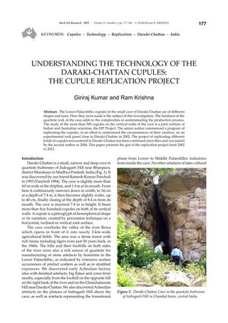
1. 177Rock Art Research 2014 - Volume 31, Number 2, pp. 177-186. G. KUMAR and R. KRISHNA
KEYWORDS: Cupules – Technology – Replication – Daraki-Chattan – India
UNDERSTANDING THE TECHNOLOGY OF THE
DARAKI-CHATTAN CUPULES:
THE CUPULE REPLICATION PROJECT
Giriraj Kumar and Ram Krishna
Abstract. The Lower Palaeolithic cupules in the small cave of Daraki-Chattan are of different
shapes and sizes. How they were made is the subject of this investigation. The hardness of the
quartzite rock of the cave adds to the complexities in understanding the production process.
The study of the more than 500 cupules on the vertical walls of the cave is a joint venture of
Indian and Australian scientists, the EIP Project. The senior author commenced a program of
replicating the cupules, in an effort to understand the circumstances of their creation, on an
experimental rock panel close to Daraki-Chattan in 2002. The project of replicating different
kinds of cupules encountered in Daraki-Chattan has been continued since then and was joined
by the second author in 2004. This paper presents the gist of the replication project from 2002
to 2012.
Introduction
Daraki-Chattan is a small, narrow and deep cave in
quartzite buttresses of Indragarh Hill near Bhanpura,
district Mandsaur in Madhya Pradesh, India (Fig. 1). It
was discovered by our friend Ramesh Kumar Pancholi
in 1993 (Pancholi 1994). The cave is slightly more than
4.0 m wide at the dripline, and 1.4 m at its mouth. From
here it continuously narrows down in width, to 34 cm
at a depth of 7.4 m, it then becomes slightly wider, up
to 40 cm, finally closing at the depth of 8.4 m from its
mouth. The cave is maximal 7.4 m in height. It bears
more than five hundred cupules on both of its vertical
walls.A cupule is a petroglyph of hemispherical shape
or its variation, created by percussion technique on a
horizontal, inclined or vertical rock surface.
The cave overlooks the valley of the river Rewa
which opens in front of it into nearly 3-km-wide
agricultural fields. The area was a dense forest with
rich fauna including tigers even just 50 years back, in
the 1960s. The hills and their foothills on both sides
of the river were also a rich source of quartzite for
manufacturing of stone artefacts by hominins in the
Lower Palaeolithic, as indicated by extensive surface
occurrences of artefact scatters as well as in stratified
exposures. We discovered early Acheulian factory
sites with finished artefacts, big flakes and cores from
nearby, especially from the foothill on the opposite hill
on the right bank of the river and on the Chanchalamata
HillnearDaraki-Chattan.WealsodiscoveredAcheulian
artefacts on the plateau of Indragarh Hill above the
cave, as well as artefacts representing the transitional
phase from Lower to Middle Palaeolithic industries
from inside the cave. No other artefacts of later cultural
Figure 1. Daraki-Chattan Cave in the quartzite buttresses
of Indragarh Hill in Chambal basin, central India.
2. Rock Art Research 2014 - Volume 31, Number 2, pp. 177-186. G. KUMAR and R. KRISHNA178
phases were found in Daraki-Chattan in 1994–95,
hence one of us postulated that the cupules inside the
cave may belong to the Acheulian or the following
transitional phase (Kumar 1995, 1996).
Most of the first half portion of the southern wall is
devoid of cupules on its surface (Fig. 2). It must have
beenexfoliatedandfallenbelowandbecomestratified.
This meant that the sloping sediments in front of the
cave should contain pieces of cupule-bearing slabs
and also some of the hammerstones used for their
production. Both were indeed amply found during
excavations (Kumar et al. 2005; Bednarik et al. 2005).
The EIP Project
In order to study the early cupules in India and es-
tablishingtheirantiquitytheEIPProjectwasestablished
during the Third AURA Congress at Alice Springs in
2000. Its name is an acronym of Early Indian Petroglyphs:
Scientific Investigation and Dating by International
Commission.ItisajointventurebyIndianandAustralian
scientists conducted in collaboration of RASI and
AURA under the aegis of IFRAO, with Giriraj Kumar
and Robert G. Bednarik as its Indian and Australian
directors. It has been supported and supervised by the
Archaeological Survey of India. Support was also given
by the Indian Council of Historical Research and the
Australia-India Council, Canberra.
Under the EIP Project excavations were carried out
at Daraki-Chattan for five seasons from 2002 to 2006,
under the supervision of the first author (Kumar et al.
2005; Kumar 2006), and 325-cm-thick sediments were
excavated. The preliminary results of the EIP Project
have been published in India, Australia and other
countries from time to time (Kumar et al. 2002, 2005,
2012; Kumar 2008, 2010a, 2010b, 2010c; Bednarik et al.
2005; Bednarik 2009a, 2012; Bednarik and Kumar 2012;
Krishna and Kumar 2012a, 2012b, 2012c). However,
a summary of the excavations is provided
here to define the typological-cultural deve-
lopment of lithics and correlation of the ex-
foliated cupules and hammerstones found
in different layers with them.
Summary of the excavations
The Lower Palaeolithic stone tool se-
quence in the Daraki-Chattan sediments
commences from the uppermost levels of the
floor deposit, which comprises only a very
thin layer of more recent strata. In places
an industry intermediate to Middle and
Lower Palaeolithic (MP and LP) typology
was visible at the surface before excavation
commenced. These intermediate tool types
are underlain by a substantial deposit de-
fined as Acheulian, but poor in typical
handaxes and cleavers. Six vague and fairly
arbitrary layers were distinguished in the
sediment, becoming progressively more
reddish in layer 5 (Bednarik et al. 2005: Fig.
26). The lowest sediment deposit is characterised
by its red colour, the upper part of which contains
severely weathered Mode 1 cobble tools as well as
hammerstones of the type used to produce the cupules
(Figs 3–5, 8a).
Arbitrary sediment layers 3 and 4 contain LP flake
artefacts,some made fromriver cobbles, but most made
of the local purplish quartzite. A few artefacts consist
of deeply patinated cherts. Layer 5 contains still much
the same industry, but increasing iron content has
effected a more reddish colour. Both stone tools and
clasts show increasing effects of weathering and iron
induration with greater depth, which on large clasts
may take the form of thick mineral crusts of primarily
ferromanganese composition.
The basal sediment layer features only very wea-
thered stone tools and clasts. Tool types from the lower
sedimentsinclude cobble tools, discoids, core choppers,
flake scrapers and polyhedrons similar to the so-called
Durkadian (for references for the following summary
see Bednarik 2009b; Bednarik and Kumar 2012). A
few specimens resemble what have been called core-
scrapers at Mahadeo-Piparia, another central Indian
site, whose repertoire has been called the Mahadevian.
These characteristic pieces are large blocks with a
zigzagging edge produced by chunky flakes having
been removed alternatively from each side.
Although LP and MP stone-tool traditions are
widespread in India, represented in massive quantities
and typologically accounted for, their absolute
chronology has remained largely unresolved so far.
This is due both to a paucity of excavated sites (most
known sites are surface scatters) and a pronounced
lack of well-dated sites. The cobble or chopping tools
preceding the bifaces of the Indian Acheulian have
attracted comparatively little attention.
While the Lower Acheulian remains largely un-
Figure 2. Part of southern wall of Daraki-Chattan near entrance,
bearing hundreds of cupules.
3. 179Rock Art Research 2014 - Volume 31, Number 2, pp. 177-186. G. KUMAR and R. KRISHNA
dated, preliminary indications suggest a late
Middle Pleistocene antiquity for the Final
Acheulian. Thorium-uranium dates from
three calcareous conglomerates containing
Acheulian artefacts (Nevasa, Yedurwadi,
Bori) suggest ages in the order of 200 ka. The
most recent date for an Indian Acheulian
deposit is currently the uranium-series
result of about 150 ka from a conglomerate
travertine at Kaldevanahalli. There remains
wide disagreement about the antiquity of the
Early Acheulian and the Mode 1 industries.
Some favour a date of 1.4 million years (Ma)
from Kukdi valley for the earliest phase of
the Acheulian; others reject it. The earliest
phase of human presence in India, of Mode
1 assemblages, remains largely undated, but
at Pabbi Hills, dates ranging from 2.2 to 1.2
Mahavebeenacquiredbypalaeomagnetism.
The few flaked quartzite cobbles from Riwat
(Pakistan) appear to be in the order of 2.5
Ma old, rather than 1.9 Ma as previously
proposed. The claims from Labli Uttarani,
ranging from 1.6 to 2.8 Ma, are viewed
sceptically. However, the earliest data from
China imply an occupation by hominins
prior to 2 Ma, which presumes human
presence in India by that time. Reliably
identified Mode 1 industries have been
excavated from secure stratigraphies in very
few cases, and they were found below Mode
2 (Acheulian) strata at the two early cupule
sites, Auditorium Cave at Bhimbetka and
Daraki-Chattan. These quartzite tools are
partially decomposed at both sites and they
were found in both cases below pisoliths and
heavy ferromanganese mineral accretions
indicating a significant climatic incursion.
Details of the typological context of the
excavated tools from Daraki-Chattan have
been published by Bednarik and Kumar
(2012: 154–55, in CD pp. 895–906).
The excavations at Daraki-Chattan have
established that the cave was a Lower Pa-
laeolithic occupation site (Figs 3 and 4).
During the excavations exfoliated cupules
and hammerstones used for the creation of
cupules (Fig. 5) were obtained from arbitrary
layer 3 down to arbitrary layer 4, 5 and from
the interface of 6/5 (Bednarik et al. 2005: Fig.
26). It means the cupules on the excavated
slabs must have been much older than their
stratigraphical antiquity, and this applies
also to the cupules on the cave walls. Thus,
the EIP Project has confirmed the evidence of
Lower Palaeolithic cupules for the first time
in the world.
It also established that with more than
five hundred cupules on both vertical walls,
Figure 3. Excavations at Daraki-Chattan: section facing south.
Figure 4. Daraki-Chattan: Oldowan type chopper on quartzite from
the lower-most level of pseudo-layer 5.
Figure 5. A slab lying close to bedrock in pseudo-layer 5/6 bearing an
oval/elliptical cupule (broken); inset close-up of the same.
4. Rock Art Research 2014 - Volume 31, Number 2, pp. 177-186. G. KUMAR and R. KRISHNA180
Daraki-Chattan is the richest known early Palaeolithic
cupulesiteintheworld(Fig.2)(Kumar1995,1996,2006;
Kumar et al. 2005; Bednarik et al. 2005).
Inadditiontohousingsomeoftheoldestknownrock
art, Daraki-Chattan is also an important Palaeolithicsite
because it is one of the very few Indian locations where
Mode 1 (pre-Acheulian) occupation evidence has been
excavated in a stratified context. Overlain by a typical
Acheulian with handaxes, this deposit has yielded very
simple,Oldowan-likestoneartefactsmademostlyofthe
local quartzite. This very early cupule site is therefore
of particular importance to exploring the LP industries
of southern Asia (Bednarik and Kumar 2012: 154–155,
in CD pp. 895–906).
Questions raised by Daraki-Chattan
The high concentration of cupules in a small cave
such as Daraki-Chattan requires an explanation. The
hardness of the quartzite rock of the cave adds more
complexities to its understanding. Common questions
being raised in reference to this site are:
1. How were these cupules made on such a hard
quartzite rock?
2. Were these cupules the creation of a single period
or were they made in different periods, and when
were they made?
3. DothecupulesinDaraki-Chattanshowadiachronic
development?
4. What was the purpose of creating such a large
number of cupules on such a small and narrow
cave?
5. What is the significance of the study of these
cupules?
Until c. 2001 it was impossible to answer such
questions scientifically. The study of the early pet-
roglyphs through the EIP Project has focused on being
able to answer some of these questions.
Study of the cupules
We made a preliminary study of the cupules in
Daraki-Chattan Cave while documenting them in
1994–95 (see Kumar 1996: Figs 5, 6). However, for
understandingthecreationofcupulesinDaraki-Chattan
through replication it was necessary to understand the
cupule forms more closely.
Categories of cupule forms in Daraki-Chattan
We studied and documented 496 cupules on both
walls of Daraki-Chattan Cave in 1995. Out of these,
402 cupules are circular or almost circular, 85 are
elongated (oval) and 9 are more angular in shape. Of
the circular cupules we distinguished two categories
in 1995: (1) saucer-shaped big circular cupules, and
(2) bowl-shaped big circular cupules (Kumar 1995).
However, later on we observed that circular cupules
have one more category: circular cupules with conical
section (Kumar and Prajapati 2010; Krishna and Kumar
2012a).
Almost all the cupules and the bedrock around
them bear light-brown patina. Most of them also bear
mineral encrustation and also show different stages of
weathering. Later on a few more cupules have been
observed near the roof of the cave on the southern wall,
and two on the bedrock of the cave floor. Besides, slabs
bearing 28 cupules were excavated during 2002–2006,
out of which two cupules were in situ (Kumar et al.
2012).
The archaic cupules in Daraki-Chattan Cave have
now been classified broadly into four categories with
their sub-categories as follows (Kumar and Prajapati
2010; Krishna and Kumar 2012a):
1. Big circular cupules with saucer-shaped floor or
deeply rounded floor (Fig. 6):
1a. Big circular cupules of more than 50 mm dia-
meterandsmoothsaucer-shapedfloor,ofmorethan
5 mm depth.
1b. Big and deep cupules of about 30 to 50 mm dia-
meter and 7 to 12 mm depth, smooth and rounded
floor; sometimes the depth is more than 12 mm.
2. Cupules with conical section:
2a. Circular cupules of about 30 to 40 mm diameter
and conical section of more than 5 mm depth (Fig.
7).
2b. Oval or elongate cupules with oblique and
conical section, deepest point is always below the
cupule’s centre (Fig. 8).
3. Small cupules:
3a. Small circular and shallow cupules which
appear to be unfinished.
3b. Small circular cupules with deep smooth
floor.
Figure 6. Big circular cupules on northern wall.
5. 181Rock Art Research 2014 - Volume 31, Number 2, pp. 177-186. G. KUMAR and R. KRISHNA
Examples on the northern wall (NR): NR 144; 24.65
× 27.0 × 11; 35 mm, deep conical cupule. NR 162.
24.5 × 23. 8 × 8. 83 mm. On southern wall: SR 195b.
32.3 × 24.6 × 8.4 mm.
4. Small cupules with angular periphery and deep
angular section. They are rare:
(1) Northern wall, on the lower side before Group
1a: 18.3 × 17.6 × 5.7 mm, with roughly triangular
periphery and angular section (it is a new cupule
observed on northern wall of the cave on 27
December 2008, hence has no number).
(2) SR 23 (Fig. 9); 27.3 ×24.6 × 8.4 mm, with roughly
triangular periphery androughly triangular section.
It is the only case of its kind and is exceptionally
difficult to produce.
(3) However, in the study of the cupules in DC in
January 2012 we observed a few more specimens
with angular periphery. Near the distal end of
the southern wall, cupule SR 174 is deep and with
roughly square periphery (Fig. 10). It could be
identified on close observation. Close to and slightly
belowit,cupuleSR200isroughlytriangularinshape
with weathered base facing upwards and rounded
upper half. Cupule SR 193 is located slightly above,
andclosetoitonitsleftsideisabigversionofcupule
SR 200 (Krishna and Kumar 2012b).
Categories1and2formthemajorbulkofthecupules
in Daraki-Chattan Cave. Category 3 forms only a small
part, while cupules of category 4 are rare. Cupules of
category 2 have been found from the excavations at
Daraki-Chattan.
Replication of cupules
In the global literature (Bednarik 1998: 23–35) on
rock art we do not have any reference for replication
work that could have helped us in understanding
the techniques used, cognition and skill required and
complexities involved in producing the cupules on
hard quartzite rock. Hence, in order to understand
the creation of cupules and their significance in
Daraki-Chattan we have been experimenting with the
replication of cupules on a selected vertical wall in a
rockshelter closely associated with and located by the
right side (south) of Daraki-Chattan (Fig. 11). It is a
continuation of the same quartzite bedrock forming
Daraki-Chattan. The rockshelter, 660 cm in breadth
Figure 7. Small circular cupules with conical depth on
southern wall.
Figure 8. An oval cupule on northern wall.
Figure 9. Roughly triangular cupule No. 23 southern
wall.
Figure 10. Roughly square shape cupule with angular
depth, No. 174 on southern wall.
6. Rock Art Research 2014 - Volume 31, Number 2, pp. 177-186. G. KUMAR and R. KRISHNA182
at the dripline, 175 cm deep and
275 cm in height at present, faces
west. The vertical wall of the
shelter runs 210 cm from north
to south, than turns to southeast
for an additional distance of 140
cm. It is 200 cm in height from the
present floor surface.
We really need to show how
hard it is to make the described
different types of cupules and
how much deliberate effort is
required in their production. Secondly, we also need to understand and
justify the nature and types of hammerstones discovered in the excavations
at Daraki-Chattan and correlate them with the cupules in the cave (Fig. 12).
Experiment with replication of cupules was commenced by GK in 2002,
the year of beginning the excavation at Daraki-Chattan. Ram Krishna
(Prajapati) joined the replication project in 2004. It is still continuing (Kumar
and Prajapati 2010; Krishna and Kumar 2012a, 2012b, 2012c). So far we have
replicated ten cupules.
Hammerstones used for practical work
Pebbles and cobbles from a nearby site, Patasighati, with purple-red
coloured core, are very hard and are most suitable for use as hammerstones
for cupule production and also to make artefacts from. They are of greater
density than the bedrock of Daraki-Chattan. They were similarly used at
this place by hominins in the Lower Palaeolithic. We also experimented with
hammerstones on chert, chalcedony, and basalt and other igneous rocks, but
they were not found suitable because of their fragile nature.
Patasighati is located in between Indragarh Hill and Chanchalamata Hill.
It contains highly cemented thick boulder conglomerate of river deposit in a
palaeochannel. So far we could not find any stone artefact or fossil remains
fromthispalaeochanneldeposit.Itmusthavebeenformedbyaverypowerful
stream of very high kinetic intensity, as the boulders up to 50 cm diameter
have become almost round, some are flat and round, hence the local name
Patasighati (valley of boulders, cobbles and pebbles like sugar cakes).
Technique used
From the study and observation of the hardness of the bedrock and
smoothness of the archaic cupules in Daraki-Chattan, GK believed
intuitively from the very beginning that these could have been produced by
direct percussion technique; hence he used the same technique for cupule
replication unless mentioned otherwise.
Summary of the replication project,
study and observations to date
The details of our replication project on different shapes and size of
cupules (Figs 13–17) and the shape of different hammerstones after their
use (Fig. 18–21) have been reported from time to time (Kumar 2010c;
Kumar and Prajapati 2010; Krishna and Kumar 2012a, 2012b, 2012c). Hence,
instead of giving these details we are presenting here a summary and a
comparative study of the replication process in Table 1. It is followed by
our understanding of the creation of different cupule forms and overall
Figure 11. Experimental rock in a rockshelter by the southern side of Daraki-Chattan (left), and some of the replica cupules
on it (right).
Figure 12. (a) A quartzite
hammerstone with broad
striking head obtained
from pseudo-layer 6 in the
excavations at Daraki-Chattan;
(b) a quartzite hammerstone
with broad striking end obtained
from pseudo-layer 5, a big flake
struck off after its use.
7. 183Rock Art Research 2014 - Volume 31, Number 2, pp. 177-186. G. KUMAR and R. KRISHNA
observation on the skill, efficiency and cognitive state
of their authors.
Comments
Our replication experiments on hard quartzite rock
by the side of DC from 2002 to 2012 have revealed some
facts about the creation of different forms of cupules in
Daraki-Chattan Cave which are as follows:
1. It is incredibly hard to replicate cupules on hard
quartzite rock. Besides, it requires immense skill
and precision.
2. Big circular cupules. In Daraki-Chattan, cupules of
category 1a, i.e. big circular cupules of more than
50 mm diameter, more than 5 mm deep and saucer
shaped, appear to be the work more of strength and
commitment and less of skill. They were produced
by using a very simple technology of direct
percussion. They appear to represent the earliest
stage of cupule production. Our cupule replication
experiment indicates that to produce cupules of
category 1a needs two to six hammerstones on
cobbles to produce such cupules, depending on
the quality of the stone used and the strength of the
Parameters Category of replicated cupules
1a - Big and saucer-
shaped cupules
2a - Small circular
cupules
with conical depth
4 - Roughly triangular cupules
Id No &
Dimensions
RC-2, big saucer-
shaped cupule
created by a young
shepherd in 2002.
Dimensions: 55.7 ×
55.0 × 9.0 mm
(Fig. 13).
RC-9, small cupule
with conical depth,
created by an
urban engineering
student in 2009.
Dimensions 32.0 ×
31.5 × 9.0 mm
(Fig. 15).
RC-6/10
Stage 1: RC-6, small cupule with conical depth,
33.5 × 32.5 × 9.0 mm (Fig. 14).
Stage 2: RC-6 was converted to RC-10, a roughly triangular
form cupule, 36.0 (breadth) × 35.0 (height) × 10.0 mm
(depth). (Figs 16 and 17).
No of strokes
and time
duration
17300 powerful
strokes in 138
minutes in 2 days,
12–13 June 2002.
28327 light strokes
in 372 minutes in
2 days, 16–17 June
2009.
Stage 1: RC-6, 21661 light strokes, in 172 minutes in 3 days,
25–27 Dec. 2008. Out of these, 3322 strokes were made by
indirect percussion in 22 minutes.
Stage 2: 89600 light strokes (direct percussion) in
640 minutes in three days, 27–29 Jan. 2012 at an average
rate of 140 strokes per minute.
Size, nature
and No. of
hammer-
stones (Hs)
used
Two Hs on big
cobbles of quartzite
were used. The Hs
has to be lifted up to
shoulder level (28 to
30 cm) to exert great
power to it while
striking.
Using
comparatively
light strokes made
by 17 small Hs, by
lifting them only
up to a height of 5
to 6 cm.
Stage 1: comparatively light strokes made by 12 small Hs,
by lifting them only up to a height of 5 to 6 cm.
Stage 2: light strokes made by three small and elongated
Hs, by lifting them only up to a height of 5 to 6 cm. Most
of the time two elongated Hs were used. A third one was
discarded after a short duration of 32 minutes only on 28
January.
Concen-
tration,
commitment,
skill, precision
and patience
required
It is a product more
of strength and
commitment, and
less of skill.
Steady work with
precision and
concentration. It
is a product of
comparatively
light strokes
made by small
hammerstones.
A roughly triangular shape of cupules became possible
because of the further experiments in the small circular
cupules with conical depth. Producing such cupules by
direct percussion is a work of high precision and great
patience and commitment. It is the further advanced
stage of cupule creation after the creation of small circular
cupules with conical depth. Its creation requires proper
planning and strategy and a lot of time as compared to
small circular cupules with conical depth.
Cognitive
develop-
ment and
intelligence
estimated
It is a product more
of dedication and
determination and
less of skill.
It is a product of
advanced skill
and precision with
great concentration
and patience.
Creation of such
cupules also
reflects a tradition
of long experience.
A small conical cupule with conical depth produced by
direct percussion forms the base to produce a triangular
form of cupule. If we shift the centre of the depth, the
cupule form will change to angular form. In the case of RC-
10 it was shifted downwards by 4–5 mm (Fig. 17).
Further, it needs innovative skill and reflects on the
advanced stage of the cognitive development of its author.
Size of an angular cupule is a function of time and also of
finding or making a suitably long and thin hammerstone.
Table 1: Comparative study of the production process and observations on the replicated cupules, and comments on them.
8. Rock Art Research 2014 - Volume 31, Number 2, pp. 177-186. G. KUMAR and R. KRISHNA184
Figure 16. Roughly triangular form of cupule, RC-10
created in January 2012.
Figure 13. Big saucer-like replica
cupule, RC-2 created in 2002.
Figure 14. Small circular cupule
with conical depth, RC-6 created
in 2008.
Figure 15. Small circular cupule
with conical depth, RC-9 created
in 2009.
Figure 20. (a) One of the hammerstones used for replication of RC-9;
(b) close up of the striking head of the same.
Figure 17. Figure showing the shifting of the centre point
of the replicated cupule to 4.5 mm downwards on the
vertical length of RC-10.
Figure 18. Hammerstone after its use in
creation of big saucer-shaped cupule RC-2.
Figure 19 (left). Hammerstone after its use in creation of cupule RC-5.
9. 185Rock Art Research 2014 - Volume 31, Number 2, pp. 177-186. G. KUMAR and R. KRISHNA
person at work. It is a tough and tedious
tasktoproduceacupuleonhardquartzite
rock, requiring motivation, commitment,
strength, endurance and patience for its
production.
3. Small circular cupules with conical section.
We successfully replicated such cupules
in December 2008 and June 2009. They
appear to be the work of modified
technologyofdirectpercussionwithsmall
hammerstones of specific shape and size.
It requires proper planning, immense skill
and great precision and patience to produce such
cupules. The person at work on cupule production
cannot afford a wrong stroke, even in a thousand, as
it increases the diameter of the cupule. Thus, these
cupules are a work of modified technology and
advancedskillandprecisionandgreatconcentration
and patience. Their creation needs comparatively
light strokes and use of multiple hammerstones. It
also reflects a tradition of long experience.
4. Elongatedcupulesaretheresultoffurtherexperiments
with small circular cupules with conical section.
5. Roughly triangular cupules. A small cupule with
conical section produced by direct percussion forms
the base to produce a roughly triangular form of
cupule. If the centre of the depth is shifted, the
cupule form will change to a roughly triangular
form. It is the main finding of our study of the
cupules in Daraki-Chattan, their close observation
and discussion followed by replication work during
January2012.Further,itneedsindividualinnovation
and reflects on the advanced stage of the cognitive
development of its author. Its production requires
light strokes applied over longer time, compared to
small circular cupules with conical section.
6. Study and understanding of the creation of roughly
angular form of cupules may help to understand the
invention and development of geometrical forms,
especially the triangular and square forms in terms
of antiquity in the Stone Age. It will also help in
understanding the antiquity of the cognitive and
cultural development of their authors.
7. Cupule creation is definitely not a leisure work or
ludic. It is a very tough job and appears to be closely
associated with something special and deeply
significant.
8. Cupule replication is found to be an important
methodforunderstandingtheprocessandtechnique
of cupule creation, in the present case on hard
quartzite rock. It renders hypotheses testable; hence
it is an important scientific exercise.
Conclusions
1. In addition to housing some of the oldest known
rock art in the world, Daraki-Chattan is also an
important Palaeolithic occupation site because it is
one of the very few Indian locations where Mode
1 (pre-Acheulian) occupation evidence has been
excavated in a stratified context. Overlain by a
typical Acheulian with handaxes, this deposit has
yielded very simple, Oldowan-like stone artefacts
made mostly of the local quartzite. This very early
cupule site is therefore of particular importance
to exploring the Lower Palaeolithic industries of
southern Asia (Bednarik and Kumar 2012).
2. It is incredibly hard to replicate cupules on hard
quartzite rock. Besides, it requires immense skill
and precision.
3. Thereplicationofcupuleshelpedusinunderstanding
thattheircreationonhardquartziterockisaverylong,
hard and labour-consuming task, involving literally
tens of thousands of strokes with hammerstones.
The struck rock being very hard, the hammerstone
rebounds with equal force with each stroke, and
gives a powerful jerk in the shoulder of the worker,
especially in case of cupule replication of categories
1a and 2a. Hence, the person working on replication
of cupule creation must have sufficient physical
strength, commitment, stamina and patience.
4. Big circular cupules, small circular cupules with
conical depth and roughly triangular cupules
created by direct percussion method may reflect a
steady advancement in technology, skill, precision,
intelligence and cognitive development in early
human history of the Pleistocene. It appears a
phenomenon more of the social and cultural
environment and also that of opportunities and
encouragementprovidedbythesocialgroupsrather
than evolution of skill in different species of the
Homo. The same is the case even at present when
we observe the development of juveniles in rural
and urban environment in different parts of the
world. We can also recall the Industrial Revolution
and development of bicycles, motor bikes, cars,
aeroplanes etc., from their modest forms in the
beginning to the modern advanced forms of the
present. The underlying nature of the culture of
our ancestors was not significantly different in a
qualitative sense from our own. Of course in the
Stone Age the development was a slow process.
Different technologies, designs, devices and
equipment were developed according to the need
of the time to make the tasks comparatively easy
and life more comfortable. Thus, cupule creation
of different forms by early humans appears to be
Figure 21. Small elongated hammerstone Hs-2, used in stage 2 of the
production of RC-10.
10. Rock Art Research 2014 - Volume 31, Number 2, pp. 177-186. G. KUMAR and R. KRISHNA186
related to cultural evolution deeply embedded in
the cognitive development in hominins.
Acknowledgments
We sincerely extend our heartfelt thanks to the four
scholars for reviewing the paper as RAR referees and for their
constructive suggestions, most of which have been taken care
of in the final version of this paper.
Professor Giriraj Kumar
Faculty of Arts
Dayalbagh Educational Institute
Dayalbagh, Agra 282 005
India
girirajrasi.india@gmail.com
Ram Krishna
Ramkrishna.gem@gmail.com
Final MS received 12 November 2013.
References
Bednarik, R. G. 1998. The technology of petroglyphs. Rock
Art Research 15: 23–35.
Bednarik, R. G. 2009a. Lower and Middle Palaeolithic
palaeoart of the world. Paper presented in Symposium
4: recent trends in word rock art research, in the IFRAO
Congress ‘Global Rock Art’ held at Capivara, Saõ Rai-
mundo Noñato, Piauí, Brazil, from 29 June to 3 July
2009.
Bednarik,R. G.2009b.TheglobalcontextofLowerPalaeolithic
Indian palaeoart. Man and Environment 34(2): 1–16.
Bednarik, R. G. 2012. Dating and taphonomy of Pleistocene
rock art. In J. Clottes (ed.), L’art pléistocène dans de monde,
ActesduCongrèsIFRAO,Tarascon-sur-Ariège,septembre
2010, Special issue, Préhistoire, Art et Sociétés, Bulletin de la
Société Préhistorique Ariège-Pyrénées LXV–LXVI: 188–189
(1059–1060 on CD).
Bednarik, R. G. 2012. Indian Pleistocene rock art in the global
context. In J. Clottes (ed.), L’art pléistocène dans de monde,
ActesduCongrèsIFRAO,Tarascon-sur-Ariège,septembre
2010, Special issue, Préhistoire, Art et Sociétés, Bulletin de la
Société Préhistorique Ariège-Pyrénées LXV–LXVI: 150–151
(869–878 on CD).
Bednarik, R. G. and G. Kumar 2012. Typological context of
the Lower Palaeolithic lithics from Daraki-Chattan Cave,
India. In J. Clottes (ed.), L’art pléistocène dans de monde,
ActesduCongrèsIFRAO,Tarascon-sur-Ariège,septembre
2010, Special issue, Préhistoire, Art et Sociétés, Bulletin de la
Société Préhistorique Ariège-Pyrénées LXV–LXVI: 154-155
(895–906 on CD).
Bednarik, R. G., G. Kumar,A. Watchman and R. G. Roberts
2005. Preliminary results of the EIP Project. Rock Art
Research 22: 147–197.
Krishna, R. and G. Kumar 2012a. Understanding the creation
of small conical cupules in Daraki-Chattan. In J. Clottes
(ed), L’art pléistocène dans de monde, Actes du Congrès
IFRAO, Tarascon-sur-Ariège, septembre 2010, Special
issue, Préhistoire, Art et Sociétés, Bulletin de la Société
Préhistorique Ariège-Pyrénées LXV–LXVI: pp. 216–217
(1229–1256 on CD).
Krishna, R. and G. Kumar 2012b. Replication of early angular
cupulesonhardquartziterockatDaraki-Chattanbydirect
percussion method. Purakala 22: 17–28.
Krishna, R. and G. Kumar 2012c. Physico-psychological
approach for understanding the significance of Lower
Palaeolithic cupules. In J. Clottes (ed.), L’art pléistocène
dans de monde, Actes du Congrès IFRAO, Tarascon-sur-
Ariège, septembre 2010, Special issue, Préhistoire, Art et
Sociétés, Bulletin de la Société Préhistorique Ariège-Pyrénées
LXV–LXVI: 156–157 (907–918 on CD).
Kumar, G. 1995. Daraki-Chattan: a Palaeolithic cupule site in
India. Purakala 6: 17–28.
Kumar, G. 1996. Daraki-Chattan: a Palaeolithic cupule site in
India. Rock Art Research 13: 38–46.
Kumar, G. 2006. A preliminary report of excavations at
Daraki-Chattan- 2006. Purakala 16: 51–55.
Kumar, G. 2008. Lower Palaeolithic petroglyphs from exca-
vations at Daraki-Chattan in India. In R. G. Bednarik
and D. Hodgson (eds), Pleistocene palaeoart of the world,
pp. 63–75. BAR International Series 1804, Archaeopress,
Oxford.
Kumar. G. 2010a. Recent developments in rock art research
in India with special reference to the EIP Project. In L.
M. Olivieri, L. Bruneau and M. Ferrandi (eds), Pictures
in transformation: rock art research between central Asia and
the subcontinent, pp. 1–12. BAR International Series 2167,
Archaeopress, Oxford.
Kumar, G. 2010b. Cognitive and creative abilities of Lower
Palaeolithic hominins in India. FUMDHAM Mentos 9:
187–195. Fundaçào Museu do Homen Americano, São
Raimundo Noñato, Brazil.
Kumar,G.2010c.Understandingthecreationofearlycupules
by replication with special reference to Daraki-Chattan
in India. In R. Querejazu Lewis and R. G. Bednarik (eds),
Mysterious cup marks: proceedings of the First International
Cupule Conference, pp. 59–66. BAR International Series
2073, Archaeopress, Oxford.
Kumar, G., R. G. Bednarik, A. Watchman and C. Patterson
2002. 2002- EIP Project report-II: sample collection for
analytical study and scientific dating of the early Indian
petroglyphs and rock paintings by the international
commission. Purakala 13(1–2): 21–28.
Kumar, G., R. G. Bednarik,A. Watchman and R. G. Roberts
2005. The EIP Project in 2005: a progress report. Purakala
14–15: 13–68.
Kumar, G. and R. K. Prajapati 2010. Understanding the
creationofcupulesinDaraki-Chattan,India.FUMDHAM
Mentos 9: 167–186. Fundaçào Museu do Homen Ameri-
cano, São Raimundo Noñato, Brazil.
Kumar, G., N. Vyas, R. G. Bednarik and A. Pradhan 2012.
Lower Palaeolithic petroglyphs and hammerstones
obtained from the excavations at Daraki-Chattan Cave
in India. In J. Clottes (ed.), L’art pléistocène dans de monde,
ActesduCongrèsIFRAO,Tarascon-sur-Ariège,septembre
2010, Special issue, Préhistoire, Art et Sociétés, Bulletin de la
Société Préhistorique Ariège-Pyrénées LXV–LXVI: 152–153
(879–893 on CD).
Pancholi, R. K. 1994. Bhanpura kshetra me navin shodha.
Purakala 5(1–2): 75.
RAR 31-1135