Addresses some of the causes of destructive forces and how they cause changes in the earth's surface. Goes with slide shows shown below.
http://www.slideshare.net/MMoiraWhitehouse/teach-erosion-and-deposition-copy and
http://www.slideshare.net/MMoiraWhitehouse/weathering-teach
Addresses some of the causes of destructive forces and how they cause changes in the earth's surface. Goes with slide shows shown below.
http://www.slideshare.net/MMoiraWhitehouse/teach-erosion-and-deposition-copy and
http://www.slideshare.net/MMoiraWhitehouse/weathering-teach
JMeter webinar - integration with InfluxDB and GrafanaRTTS
Watch this recorded webinar about real-time monitoring of application performance. See how to integrate Apache JMeter, the open-source leader in performance testing, with InfluxDB, the open-source time-series database, and Grafana, the open-source analytics and visualization application.
In this webinar, we will review the benefits of leveraging InfluxDB and Grafana when executing load tests and demonstrate how these tools are used to visualize performance metrics.
Length: 30 minutes
Session Overview
-------------------------------------------
During this webinar, we will cover the following topics while demonstrating the integrations of JMeter, InfluxDB and Grafana:
- What out-of-the-box solutions are available for real-time monitoring JMeter tests?
- What are the benefits of integrating InfluxDB and Grafana into the load testing stack?
- Which features are provided by Grafana?
- Demonstration of InfluxDB and Grafana using a practice web application
To view the webinar recording, go to:
https://www.rttsweb.com/jmeter-integration-webinar
State of ICS and IoT Cyber Threat Landscape Report 2024 previewPrayukth K V
The IoT and OT threat landscape report has been prepared by the Threat Research Team at Sectrio using data from Sectrio, cyber threat intelligence farming facilities spread across over 85 cities around the world. In addition, Sectrio also runs AI-based advanced threat and payload engagement facilities that serve as sinks to attract and engage sophisticated threat actors, and newer malware including new variants and latent threats that are at an earlier stage of development.
The latest edition of the OT/ICS and IoT security Threat Landscape Report 2024 also covers:
State of global ICS asset and network exposure
Sectoral targets and attacks as well as the cost of ransom
Global APT activity, AI usage, actor and tactic profiles, and implications
Rise in volumes of AI-powered cyberattacks
Major cyber events in 2024
Malware and malicious payload trends
Cyberattack types and targets
Vulnerability exploit attempts on CVEs
Attacks on counties – USA
Expansion of bot farms – how, where, and why
In-depth analysis of the cyber threat landscape across North America, South America, Europe, APAC, and the Middle East
Why are attacks on smart factories rising?
Cyber risk predictions
Axis of attacks – Europe
Systemic attacks in the Middle East
Download the full report from here:
https://sectrio.com/resources/ot-threat-landscape-reports/sectrio-releases-ot-ics-and-iot-security-threat-landscape-report-2024/
UiPath Test Automation using UiPath Test Suite series, part 4DianaGray10
Welcome to UiPath Test Automation using UiPath Test Suite series part 4. In this session, we will cover Test Manager overview along with SAP heatmap.
The UiPath Test Manager overview with SAP heatmap webinar offers a concise yet comprehensive exploration of the role of a Test Manager within SAP environments, coupled with the utilization of heatmaps for effective testing strategies.
Participants will gain insights into the responsibilities, challenges, and best practices associated with test management in SAP projects. Additionally, the webinar delves into the significance of heatmaps as a visual aid for identifying testing priorities, areas of risk, and resource allocation within SAP landscapes. Through this session, attendees can expect to enhance their understanding of test management principles while learning practical approaches to optimize testing processes in SAP environments using heatmap visualization techniques
What will you get from this session?
1. Insights into SAP testing best practices
2. Heatmap utilization for testing
3. Optimization of testing processes
4. Demo
Topics covered:
Execution from the test manager
Orchestrator execution result
Defect reporting
SAP heatmap example with demo
Speaker:
Deepak Rai, Automation Practice Lead, Boundaryless Group and UiPath MVP
DevOps and Testing slides at DASA ConnectKari Kakkonen
My and Rik Marselis slides at 30.5.2024 DASA Connect conference. We discuss about what is testing, then what is agile testing and finally what is Testing in DevOps. Finally we had lovely workshop with the participants trying to find out different ways to think about quality and testing in different parts of the DevOps infinity loop.
Epistemic Interaction - tuning interfaces to provide information for AI supportAlan Dix
Paper presented at SYNERGY workshop at AVI 2024, Genoa, Italy. 3rd June 2024
https://alandix.com/academic/papers/synergy2024-epistemic/
As machine learning integrates deeper into human-computer interactions, the concept of epistemic interaction emerges, aiming to refine these interactions to enhance system adaptability. This approach encourages minor, intentional adjustments in user behaviour to enrich the data available for system learning. This paper introduces epistemic interaction within the context of human-system communication, illustrating how deliberate interaction design can improve system understanding and adaptation. Through concrete examples, we demonstrate the potential of epistemic interaction to significantly advance human-computer interaction by leveraging intuitive human communication strategies to inform system design and functionality, offering a novel pathway for enriching user-system engagements.
GraphRAG is All You need? LLM & Knowledge GraphGuy Korland
Guy Korland, CEO and Co-founder of FalkorDB, will review two articles on the integration of language models with knowledge graphs.
1. Unifying Large Language Models and Knowledge Graphs: A Roadmap.
https://arxiv.org/abs/2306.08302
2. Microsoft Research's GraphRAG paper and a review paper on various uses of knowledge graphs:
https://www.microsoft.com/en-us/research/blog/graphrag-unlocking-llm-discovery-on-narrative-private-data/
The Art of the Pitch: WordPress Relationships and SalesLaura Byrne
Clients don’t know what they don’t know. What web solutions are right for them? How does WordPress come into the picture? How do you make sure you understand scope and timeline? What do you do if sometime changes?
All these questions and more will be explored as we talk about matching clients’ needs with what your agency offers without pulling teeth or pulling your hair out. Practical tips, and strategies for successful relationship building that leads to closing the deal.
Accelerate your Kubernetes clusters with Varnish CachingThijs Feryn
A presentation about the usage and availability of Varnish on Kubernetes. This talk explores the capabilities of Varnish caching and shows how to use the Varnish Helm chart to deploy it to Kubernetes.
This presentation was delivered at K8SUG Singapore. See https://feryn.eu/presentations/accelerate-your-kubernetes-clusters-with-varnish-caching-k8sug-singapore-28-2024 for more details.
Elevating Tactical DDD Patterns Through Object CalisthenicsDorra BARTAGUIZ
After immersing yourself in the blue book and its red counterpart, attending DDD-focused conferences, and applying tactical patterns, you're left with a crucial question: How do I ensure my design is effective? Tactical patterns within Domain-Driven Design (DDD) serve as guiding principles for creating clear and manageable domain models. However, achieving success with these patterns requires additional guidance. Interestingly, we've observed that a set of constraints initially designed for training purposes remarkably aligns with effective pattern implementation, offering a more ‘mechanical’ approach. Let's explore together how Object Calisthenics can elevate the design of your tactical DDD patterns, offering concrete help for those venturing into DDD for the first time!
De-mystifying Zero to One: Design Informed Techniques for Greenfield Innovati...
Trabajo recuperacion 1evaluacion 1bilingual
1. UNIT 1: MAPS
1.- Fill the gaps with a suitable word from the box. You only need 14 words:
SPHERICAL
NORTH USE
PARALLELS GEOID
GLOBES
MAPS
DETAILED
SPHERE MERIDIANS FLATTENED
COMPASS
EQUATOR
REGIONAL
THREE-DIMENSIONAL DISTANCES
GLOBES
TWO-DIMENSIONAL
SUN DETAILED
Globes and maps
The Earth is _________________. However, it is not a perfect ____________. It is slightly ___________ at the
poles. This shape is called a ____________.
___________ represent the Earth accurately, because they have a similar shape: they are
__________________. However, they do not usually contain ___________ information.
___________ are the most common representations of the Earth. Maps are easy to _________and carry
around. They provide __________ and practical information at a local, __________ or international level.
However, maps are not as accurate as _____________, because they are _______________. Consequently,
shapes and _______________ are distorted.
2.- Answer the following questions about Establishing direction:
What do we use the cardinal points for?
What are the principal cardinal points?
Explain how the Sun can help us to establish direction.
What element in the sky always indicates the north?
What instrument with a magnetic needle always points north?
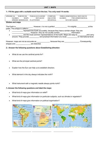
3.-Answer the following questions and label the maps:
What kind of maps give information on relief?
What kind of maps give information on particular subjects, such as climate or vegetation?
What kind of maps give information on political organisation?
___________________ ___________________
___________________
2. 2.- Match each word to its definition:
Arrow
indicates how many times the area represented has been
reduced.
Title
contains the symbols which represent information on the map.
Parallels and
meridians
names of places or other information on the map.
Key
are imaginary lines which establish the exact location of places.
Text
shows what the map is about, the area which is represented, the
subjetc, etc.
Scale
pointing north enables us to establish orientation.
3.- Find the suitable word for the following definitions:(2 points)
Semicircles which go from one pole to another.__________________
An important parallel located south of the Tropic of Capricorn. .__________________
The point of reference for other meridians. .__________________
An important parallel located north of the Equator. .__________________
Circles which are perpendicular to the meridians. .__________________
The point of reference for other parallels. .__________________
An important parallel located south of the Equator. .__________________
Hemisphere which is located north of the Equator. .__________________
An important parallel located north of the Tropic of Cancer. .__________________
Hemisphere which is located south of the Equator. .__________________
4.- Fill the following boxes with a correct concept.
3. 5.-Fill the gaps with a suitable word from the box. You only need 10 words:
MERIDIANS
COMPASS
POLES
LOCATED
(GEOGRAPHICAL COORDINATES)
LATITUDE
GLOBES
VERTICALLY
MAPS
HEMISPHERE
EAST
GEOID
EQUATOR
LOCATIONS
LONGITUDE
Latitude and longitude
Latitude and longitude indicate __________________________: the exact location of a place on the Earth.
_________________ is measured by using the parallels which start at the _________________ (0º). At the
poles they are _________________. They are north (N) or south (S) depending on whether they are
_________________ in the northern or southern hemisphere. All _________________ on a line have the same
_________________.
_________________ is measured by using the _________________ which star at the prime meridian (0º). They
run _________________ from 0º to _________________ to the west (W), and 0º to 180º to the
_________________ (E). All locations on a _________________ have the same _________________.
The combination of latitude and longitude gives us the _________________ of a place.
6.- Identify the coordinates. (1,1 points)
4. UNIT 2: RELIEF
1.- Label the parts of the Earth.
2.- Classify these words.
Mountains
Ocean trenches
Continental shelves
Continental relief
Cape
gulf
Island
Continental slopes
isthmus
Ocean ridges
Coastal
Plains Basins
Plateaus
Oceanic relief
3.- Name the parts of the course of a river and say in which part there is erosion, transport and sedimentation.
5. 4.- Answer the following questions about the causes of erosion:
●
What are the most important agents of erosion?
●
What is the consecuence of abrupt changes in temperature?
●
Where is there a great difference between daytime and nighttime temperatures?
●
How can water break rocks?
5.- Fill the gaps about the erosion produced by water. Use the words on the box. There are 5 words that you don´t
have to use.
WATER WIND
CAVES
LIMESTONE
DEPOSITS
STEEP
SAND
CANYONS TRANSPORTS
VALLEYS
ERODED
FARMING
ERODE
CURRENTS
GENTLER
BEACHES
MARINE
SEDIMENT
SOLUTION
DISSOLVES
FLUVIAL
FLATTER
SOIL
WAVES
LANDSCAPES
________1______ acts constantly on the land:
● ________2______: water ____3__________ some rocks, such as _______4_______, producing unusual
_____5_________ and landscapes.
● ________6______ erosion::
○ Rivers travel fast down ________7______ slopes. They _________8_____ materials, and create deep
____9__________ and ________10______.
○ When the slopes are _____11_________, the water moves more slowly. It transports the
________12______ materials.
○ When rivers arrive at the ____13__________ lands which are near the sea, they deposit
________14______ on their banks. These areas are known as alluvial plains.
● _______15_______ erosion:
○ ________16______ and ____17__________ wear away coasts and create cliffs. Subsequently, the
water _____18________ the sediment and _______19_______ it. This process forms
________20______.
1
2
3
4
5
6
7
8
9
10
11
12
13
14
15
16
6.- Label the pictures with a suitable type of erosion. (0.4 points)
17
18
19
20
6. 7.-Answer the following questions:
What theory developed the German scientist Alfred Wegener?
What is this theory about?
What is the name of the only continent that existed 225 million years ago?
What continents where there 135 million years ago?
8.- Match the sentences and write the whole sentences:
1
1 The tectonic plates
A often undulates where plates collide.
2
2 The tectonic plates
B is still rising.
3 Some plate move apart
C are in continuous movement.
4 The Earth´s surface
D blocks rise or sink.
4
5 The Earth´s crust sometimes fractures
E while others collide.
5
6 Where faults are created
F if the surface where plates collide is very extremely rigid.
7 The Himalaya mountain range in Asia
G move slowly at a speed of two to ten centimetres per year.
3
6
7
9.- Answer the following questions:
What happens when a volcano erupts?
How are islands, such as the Canary Islands, formed?
Where are volcanoes generally found?
7.
What elements are found in the same areas as volcanoes?
How are earthquakes caused?
10.- Label the parts of a volcano. (0,4 points)
11.- Give a definition for the following terms:
Volcano
Earthquakes
Tsunamis
12.- Locate the following landforms on the physical world map.
1.- Rocky mountains
6.- Appalachian mountains
2.- Ural mountains
7.- Balkans
3.- Atlas mountains
8.- Tibetan Plateau
4.- Andes mountains
9.- Himalayas
5.- Great Dividing range
10.- Drakensberg mountains
8. UNIT 3: WATER
1. Put the stages in the water cycle in the correct order:
a. Groundwater goes into the sea.________
b. River water goes into the sea and other rivers. ________
c. Water from the sea evaporates. ________
d. Condensed vapour falls as precipitation. ________
e. Water vapour rises, cools and condenses. Clouds form. ________
f. Wind moves the clouds. ________
g. Some water infiltrates into the ground.
2.- Answer the following questions:
What are rivers?
9.
Define "tributary"
Define "basin"
Define "flow"
3.- True or false. If they are wrong, correct them.
a. Oceans provide us with food.
b. Raw materials and energy are provided by the oceans.
c. Large quantities of gas and petroleum are found in the continental shelves.
d. Salt is obtained from rivers.
e. Oceans attract tourism to the coasts.
f.
Tourism does not create jobs in coastal areas.
g. Oceans are used for transport.
h. Oceans transport just people.
4.- Read the definitions and decide what they refer to :
a. It refers to the quantity of salt.____________
b. They are large masses of water, similar to rivers, which can be warm or cold. ____________
c. They are caused by the gravitational forces of the Moon and Sun acting on the water. ____________
d. Wind produces these undulations on the surface of the water. ____________
e. This product comes from the sea and is used for cooking. ____________
5.- Answer the following questions about lakes:
●
Define Lakes
●
Define Lagoons
●
Define inland seas
●
Make a diagram of the origin of the water in lakes.
10. 6.- Answer the following questions about groundwater
1. Where does groundwater run and where is it stored?
2. Where does most of the water come from?
3. When it rains, what happens with some of the water?
4. What happens when this water reaches impermeable rocks?
5. Define "aquifer"
6. What does groundwater form when it finds a way to the surface?
7. Make a diagram of the value of groundwater.
7.- Answer the following questions about glaciers and icebergs:
What kind of water is there in a glacier?
Define "glacier"
Where are glaciers found?
What happens when a glacier reaches the sea?
Define "iceberg"
11. 8.- Find the correct term for the following definitions:
●
A shortage of water can produce this:_____________
●
An excess of water can produce this::_____________
●
It occurs when large amounts of materials are added to a body of water.:_____________
●
It contains harmful chemicals such as sulphur and nitrogen.:_____________
9.- Complete the gaps using a word from the box. (1 point)
Chemicals (water cycle) rainfall gases (Acid rain) transformationclouds
___________ contains harmful chemicals such as sulphur and nitrogen. These ____________ are released
into the atmosphere as _________. They undergo a chemical _______________and are absorbed by the
water in ____________. They become part of ___________ and enter in the _____________________.
10.- Label the following pictures related to water.