1) Canada experiences summer when the Earth is at its greatest distance from the Sun because the tilt of the Earth's axis causes the northern hemisphere to receive more direct sunlight during its summer.
2) The document contains questions about the Earth's orbit around the Sun and how it causes the seasons, as well as diagrams showing the positions and paths of the Sun and Earth at different times of the year.
3) The questions assess the learner's understanding of how the tilt of the Earth's axis and its revolution around the Sun result in the seasons for different locations on Earth.
The document discusses key concepts related to reflection of light, including:
1) Luminous objects generate their own light, while illuminated objects reflect light. Reflection occurs when light bounces off a smooth, shiny surface at the same angle as it hits the surface.
2) The incident ray strikes the mirror, and the reflected ray leaves the mirror and strikes the eye, forming the line of sight from the image to the eye.
3) The angle of incidence equals the angle of reflection.
The document discusses sea breezes and land breezes, which are caused by differences in how quickly land and water absorb and release heat. Water has a higher specific heat than land, so it warms and cools more slowly. During the day, land is heated faster by the sun through radiation. Warmer air over land rises through convection, pulling in the cooler air from over the ocean, creating a sea breeze. At night, land cools faster while the ocean retains heat, reversing the convection currents and forming a land breeze as the cooler air over land moves over the ocean.
The document contains diagrams and questions about the seasons on Earth and how they are caused by the tilt of Earth's axis and its orbit around the Sun. It discusses how the amount of sunlight received at the North Pole and South Pole changes throughout the year, causing different seasons in each hemisphere. It also shows diagrams of Earth in different positions along its orbit and asks questions about which hemisphere would be experiencing summer or winter in each case.
The document contains diagrams and questions about the seasons on Earth and how they are caused by the tilt of Earth's axis and its orbit around the sun. It discusses how the distribution of sunlight throughout the year causes summer in one hemisphere when it is winter in the other. It also addresses how Earth's rotation on its axis causes day and night and how a year is defined as one full orbit around the sun.
The document contains information and questions about the phases of the Moon as seen from Earth. It explains that the Moon orbits Earth about once a month, causing the monthly cycle of moon phases seen from our planet. Diagrams show the relative positions of the Moon, Earth, and Sun during different moon phases. Multiple choice questions test understanding of moon phases and their sequence over a month.
The Earth has two movements: rotation and revolution. Rotation is the Earth spinning on its axis every 24 hours, causing day and night. Revolution is the Earth orbiting the Sun every 365 days, causing seasons and years. Due to these movements, different parts of the Earth receive varying amounts of sunlight, influencing climate zones and seasons. The tilt of the Earth's axis and its position in orbit also affect the length of daylight and temperature changes throughout the year.
Equinoxes occur twice yearly when the sun is directly above the equator and day and night are approximately equal in length. Solstices occur twice yearly when the sun reaches its highest or lowest point in the sky, resulting in the longest and shortest days of the year in the summer and winter respectively in each hemisphere. The document then provides details on the timing and effects of the summer and winter solstices and spring and autumnal equinoxes in both hemispheres.
Electrons orbit the nucleus of an atom and are generally negatively charged. Protons are positively charged and combine with electrons and neutrons to form atoms. Neutrons have no charge and determine the isotope of an element. Atoms consist of a nucleus surrounded by electrons, which are made up of protons, neutrons, and electrons. When an element gains protons, it acquires a positive charge, while gaining electrons gives a negative charge. Charging by contact occurs when a charged object transfers some of its charge to a neutral object they touch. Induction charging can also occur without direct contact when a charged object polarizes a nearby neutral object.
This document explains how solar energy drives key atmospheric phenomena like winds, monsoons, and the Intertropical Convergence Zone (ITCZ). It describes that during the day, uneven heating of the Earth's surface by the sun causes some areas to warm up quicker than others. Warm air rises and surrounding air is drawn in to replace it, setting winds and air currents in motion. Monsoons occur when shifting wind patterns bring seasonal rainfall to regions, which farmers rely on but can worry fishermen and fish pond owners. The ITCZ is the zone where the winds of the northern and southern tropics meet due to the rising of warm air in that region, which can lead to thunderstorms.
The sun is the largest object in the solar system, containing over 99% of its mass. It emits light and heat that support life on Earth and influence all solar system objects. The sun has various internal layers, including the core where energy is produced through nuclear fusion, and an outer atmosphere. Sunspots, solar flares, and other features periodically appear on its surface. In a few billion years, the sun will expand and grow hotter, eventually making Earth uninhabitable.
The document discusses the causes of seasons and eclipses. It explains that the seasons are caused by four main factors: the tilt of the Earth's axis, which results in one hemisphere receiving more direct sunlight; the Earth's revolution around the sun, which affects the exposure of each hemisphere to solar energy; the direct rays of sunlight, with more direct exposure resulting in warmer weather; and the length of daylight, with longer days exposing an area to more solar energy. Eclipses occur when the sun, moon, and Earth are perfectly aligned, allowing either the moon to block the sun during a solar eclipse or the Earth to block the moon during a lunar eclipse. Eclipses can be either total within the umbra shadow or
1) The Earth revolves around the sun in an elliptical orbit over the course of 1 year, and its axial tilt of 23.5 degrees relative to the orbital plane causes the seasons.
2) As the Earth revolves, its hemispheres alternate between tilting towards and away from the sun, resulting in the summer and winter seasons in each hemisphere.
3) An analemma diagram can be used to determine the position of the subsolar point, solar noon time, and solar altitude for any location on Earth on any given date throughout the year.
This document contains a 25 question multiple choice test about concepts related to space, the solar system, and the Earth's rotation and revolution. The questions cover topics like the causes of day and night, seasons, phases of the moon, the order and relative distances of planets from the sun, and characteristics of objects like comets, asteroids, and sunspots.
The document discusses how climate is determined by averaging weather conditions over many years, as opposed to weather which describes short term atmospheric conditions. It also explains that latitude affects climate, with the tropics receiving the most solar radiation and heat year-round, the polar zones receiving radiation at a low angle and remaining cold, and temperate zones in between experiencing moderate temperatures and seasonal changes.
The document discusses the Earth, moon, and sun. It provides facts about each including that the Earth revolves around the sun every 365 days, rotates on its axis every 24 hours causing day and night, and the moon revolves around the Earth every 29 days. It also notes that the sun is the largest object in the solar system and discusses phases of the moon.
Sundials can take several forms depending on their design and purpose. The simplest is a shadow stick sundial, which uses a stick or pole's shadow to indicate time, but isn't accurate year-round. An equatorial sundial points its style towards the pole star to keep a constant shadow rate, but has limited use at higher latitudes. The most accurate design has a horizontal dial kept at the observer's latitude, calibrated to account for the sun's changing rate of motion across the sky and providing local time.
The document discusses the causes of seasons. It explains that seasons are not due to variations in Earth's distance from the sun, as some believe, but are instead caused by the tilt of Earth's 23.5 degree axis. This tilt results in changes in the amount of incoming solar radiation (insolation) and the angle at which the sun's rays strike different locations throughout the year, causing the seasons to change. Specifically, when a hemisphere is tilted toward the sun it experiences summer, and when tilted away it experiences winter.
Here is a reflection page for the Earth's Motions unit:
Cartoon: I drew a cartoon showing Earth rotating on its axis while also revolving around the Sun. Night and day are passing by, and the seasons are changing as Earth makes its yearly journey. In the speech bubbles, Earth says "Wow, it sure gets busy making a full rotation and revolution each day and year! No wonder humans had a hard time figuring all this out - it must look really confusing from down here on the surface."
Poem:
Spinning round and round each day,
Bringing light then taking it away.
Wobbling slightly as I go,
On my yearly trip around the glowing glow.
Summer
The document defines key terms related to the reflection of light such as normal, angle of incidence, and angle of reflection. It states that the angle of incidence is equal to the angle of reflection and uses this principle in calculations and measurements. Examples are provided to demonstrate calculating angles of incidence and reflection from diagrams of light rays reflecting off plane mirrors.
The document discusses lunar and solar eclipses. It explains that lunar eclipses occur when the Earth passes between the sun and moon, casting its shadow on the moon. Solar eclipses occur when the moon passes between the Earth and sun, casting its shadow on parts of Earth. Eclipses only occur when the sun, Earth, and moon are aligned on the same plane. The document provides details on the conditions required to see each type of eclipse and diagrams demonstrating the geometry of lunar and solar eclipses.
An eclipse occurs when one celestial body blocks the light of another from an observer's perspective on Earth. There are two main types - solar eclipses where the moon passes in front of the sun, and lunar eclipses where the moon passes through the Earth's shadow. During a solar eclipse, the moon's shadow falls on parts of Earth and the sun appears darkened; there are three types depending on how much of the sun is covered. A lunar eclipse is visible over a larger area as the moon passes through the Earth's shadow and takes on a reddish hue. Eclipses can last up to seven minutes and a total solar eclipse occurs about every 1.5 years.
The Earth's seasons are caused by its axial tilt of 23.45 degrees, not variations in its distance from the Sun. This tilt means the Northern and Southern Hemispheres receive sunlight at different angles throughout the year, causing summer to be warmer than winter. The solstices mark the longest and shortest days of the year, while the equinoxes occur when day and night are equal in length and mark the first days of spring and fall.
Stars are giant balls of gas that produce energy through nuclear fusion. They vary greatly in size, temperature, luminosity, and lifespan. The universe contains over 100 billion galaxies, each with over 100 billion stars. Stars appear different colors due to their temperatures, from hot blue/white stars to cooler orange/red giants and supergiants. Constellations are patterns of stars in the night sky used for navigation.
The document provides an overview of astronomy and the progression of models of the universe. It discusses early geocentric models with Earth at the center, Copernicus' heliocentric model placing the Sun at the center, and Kepler's model showing elliptical orbits. Newton later explained gravitational forces and inertia keeping planets in orbit. The effects of Earth's rotation and revolution are described, including day/night cycles and the seasons.
The document provides information and review materials for an upcoming Earth Science exam. It outlines what to bring and not bring to the exam, when and where the exam will take place, and study tips. It emphasizes preparing for the exam by studying a little each night, using past exams and diagrams. On exam day, students are advised to arrive on time, use their time fully, and utilize the reference tables provided. The goal is for students to pass the exam and finish the school year.
The Earth rotates on its axis, which passes through the North and South Poles, and revolves around the Sun. The equator divides the Earth into the Northern and Southern Hemispheres. Rotation causes day and night, while revolution results in the four seasons - spring, summer, autumn and winter.
This document provides information on solar tracking systems and photovoltaic panels. It discusses how solar tracking systems can increase the efficiency of photovoltaic panels by keeping them oriented towards the sun throughout the day. By maintaining an angle of incidence close to 0 degrees, solar tracking maximizes the amount of sunlight absorbed. This can boost the output of PV panels by 30-50% compared to fixed panels. The document also provides details on the components and functioning of solar tracking systems, including sensors, microcontrollers and motors. It examines how improvements in solar cell technology and solar tracking have increased the viability of solar power as a renewable energy source.
This document is a report submitted for the degree of Bachelor of Technology in Electronics and Communication Engineering. It discusses the design of a solar tracking system using a microcontroller. The system aims to use sensors to detect sunlight and motors to adjust the position of a solar panel to maximize sunlight exposure. It provides objectives of the project and lists main components as sensors, DC motors, panels and microcontrollers. It also includes sections on the theoretical background of these components and a literature review of past solar tracking system projects.
Project details - I have made a project Dual Axis Solar Tracker using Arduino to align the solar panel towards the higher density of Sun light. I have used a ATMEGA168 controller IC for programming, and two servo motor for movement of solar panel. It was now also available on EngineersGarage with the link- http://www.engineersgarage.com/contribution/how-to-make-a-solar-tracker. Check this out.
1) The document is a quiz about concepts in astronomy including Earth's rotation, the seasons, time zones, and the Coriolis effect.
2) Key evidence of Earth's rotation includes the movement of Foucault pendulums and the deflection of winds and ocean currents due to the Coriolis effect.
3) The Coriolis effect causes winds in the northern hemisphere to curve to the right and winds in the southern hemisphere to curve to the left as a result of Earth's rotation.
This document is a worksheet about astronomy and evidence for Earth's rotation. It contains multiple choice questions about topics like the Coriolis effect, Foucault pendulums, sunrise times, and how Earth's rotation causes the apparent movement of stars and celestial objects in the sky. The answer key at the end provides the correct response for each question.
This document contains a science worksheet about seasons and the Earth's orbit around the sun. It includes 10 multiple choice questions about topics like which hemisphere is experiencing summer in a diagram of Earth, the causes of seasons, the tilt of Earth's axis, and how sunlight and daylight hours vary between hemispheres at different times of year. Diagrams are provided to help answer some of the questions.
1) The document is a science worksheet about astronomy and concepts related to the rotation and revolution of the Earth. It contains 10 multiple choice questions about topics like the position of the sun at different times of day, how the Earth's rotation affects day length, the direction of sunset, and time zones.
2) The questions cover a range of foundational astronomy topics for middle school students, including how the tilt of the Earth's axis causes changes in sunlight throughout the day and year, how the Earth's rotation creates day and night cycles, and how time zones relate to the Earth's rotation.
3) The worksheet provides diagrams and illustrations to supplement the multiple choice questions and help students visualize astronomy concepts like the Earth's
1) The document is a science worksheet about astronomy and concepts related to the rotation and revolution of the Earth. It contains 10 multiple choice questions about topics like the position of the sun at different times of day, how the Earth's rotation affects day length, the direction locations are facing on Earth, and time zones.
2) The questions cover basic concepts in astronomy like how the tilt of the Earth's axis and its rotation cause changes in sunlight and shadows over the course of a day and year.
3) The worksheet uses diagrams of the Earth from above the North Pole along with illustrations of the sun's position at different locations and times to demonstrate astronomical phenomena like why we experience days and years.
The document contains information about factors that influence insolation, such as angle, intensity, and duration. It discusses how air temperature rose faster in Florida than New York due to Florida having a higher angle of insolation. It also contains graphs and diagrams showing relationships between insolation and energy usage/shadow length at different locations and times. Multiple choice questions assess understanding of these concepts.
1. The document contains a practice test on astronomy concepts related to the Moon, including its phases, orbit around Earth, and effects on ocean tides.
2. There are 25 multiple choice questions testing knowledge of the Moon's motion and position relative to Earth and how that determines what phase is visible from different locations on Earth's surface.
3. Additional concepts covered include solar eclipses, spring tides, and how the positions of the Moon cause highest and lowest ocean tides on Earth.
This document contains 51 multiple choice questions about seasons and the apparent motion of the Sun as seen from Earth. The questions cover topics like the Sun's daily path, how the path changes throughout the year in different locations, factors that affect insolation, and seasonal changes in day length and the Sun's altitude. Diagrams are provided to illustrate concepts like the Sun's position and shadows at solar noon on different dates for various latitudes.
1) The density of an ice cube is less than the density of liquid water, as an ice cube's molecules are farther apart than in water.
2) As an air mass is heated, its density generally decreases due to thermal expansion.
3) In the Northern Hemisphere, surface winds around a low-pressure system circulate counterclockwise and inward, while they circulate clockwise and outward around a high-pressure system.
The document discusses the motions of the Earth - rotation and revolution. It provides the following key details:
1. The Earth rotates on its axis, completing one rotation in 24 hours, which causes day and night. It revolves around the Sun, taking 365.25 days to complete one revolution.
2. The Earth's axis is inclined at an angle of approximately 23.5 degrees relative to the orbital plane. This inclination causes the seasons.
3. A leap year has 366 days to account for the extra time in the Earth's revolution around the Sun.
The document defines key terms related to the Earth such as equinox, moon eclipse, core, and ocean trench. It then provides information about the layers of the Earth's geosphere and answers questions about the Earth's orbit, the moon's orbit, the causes of seasons, and other facts. Some questions are about a diagram showing the Earth's tilt and rotation and how it impacts seasons in different hemispheres.
The document discusses various celestial models including the geocentric and heliocentric models of the solar system. It provides diagrams of the positions of Earth, Moon, and Sun to illustrate phenomena like solar eclipses and ocean tides. Multiple choice questions test understanding of these concepts and which evidence supports that the Earth rotates and revolves rather than being stationary.
The Sky
Astronomy is about us. As we learn about astronomy, we learn about ourselves. We search for an answer to the question “What are we?” The quick answer is that we are thinking creatures living on a planet that circles a star we call the sun. In this chapter, we begin trying to understand that answer. What does it mean to live on a planet?
The preceding chapter gave us a quick overview of the universe, and chapters later in the book will discuss the details. This chapter and the next help us understand what the universe looks like seen from the surface of our spinning planet.
But appearances are deceiving. We will see in Chapter 4 how difficult it has been for humanity to understand what we see in the #sky every day. In fact, we will discover that modern science was born when people tried to understand the appearance of the sky.
This document is an astronomy worksheet with questions about the apparent motion of stars and concepts like the Earth's rotation. It contains 10 multiple choice questions about topics like how stars appear to rise and set due to the Earth's rotation, how the position of Polaris changes with latitude, explanations for the daily motion of stars, and models of the solar system. It provides a diagram of an instrument used to measure star positions as well as a diagram of an orbiting planet's motion around a star.
TEST BANK For Astronomy A Beginners Guide to the Universe, 8th Edition by Cha...rightmanforbloodline
TEST BANK For Astronomy A Beginners Guide to the Universe, 8th Edition by Chaisson, Verified Chapters 1 - 18, Complete Newest Version.
The document provides information about maps and geography. It defines key map terms like scale, cardinal directions, components of a map, and how symbols are used. It distinguishes between different types of maps like physical, thematic, and political maps. Maps are explained to be more useful than globes for studying specific areas due to their level of detail. Thematic maps provide detailed information on topics like forest distribution. A compass is used to find main directions, and a scale is necessary for maps but not sketches or symbols.
This document contains a 20 question astronomy review packet covering topics like the formation of the solar system, stellar evolution, properties of stars and galaxies. It includes diagrams and tables to reference in answering multiple choice and short answer questions. The review covers the life cycles of stars of different masses, including our Sun, as well as properties of planets, asteroids and galaxies.
Lab #2Sun Angles, Daylength, Insolation, and Temperature Patter.docxjesseniasaddler
Lab #2:
Sun Angles, Daylength, Insolation, and Temperature Patterns
Insolation
The sun is the single most important source of energy on the surface of the Earth as well as the atmosphere.
The distribution of the Earth’s atmospheric phenomena and climate patterns, as well as the distribution of its ecosystems, are significantly influenced by the distribution of incoming solar radiation.
In heating the Earth’s atmosphere, visible light is the most important part of the sun’s electromagnetic spectrum.
This exercise examines sun angle and intensity of insolation, daylength and temperature patterns on the earth’s surface.
These variables are examined as they interrelate on the Earth’s surface over the course of a year.
Sun Angle
Because solar energy received by the earth follows essentially parallel pathways, and because the earth is spherical, at only one place on the earth’s surface can the sun’s rays strike vertically (this is known as the
subsolar point
).
In other words, at only one place at any one time can the sun appear directly overhead.
This occurs at
solar noon
when the sun reaches the highest position in the sky for that day.
Because of the earth's limited axial tilt, the sun can appear directly overhead at the
subsolar point
at a relatively narrow range of latitudes over the course of a year (between 23.5° N and 23.5° S).
An important relationship exists between latitude and the angle of the
noon
sun.
On the equinoxes (on March 21 or 22 and September 21 or 22) the sun’s rays are perpendicular to the earth at the equator.
Those same rays would also be tangent at both of the poles, so that the sun would appear only on the horizon at those locations.
On the same dates an observer at 30° N would record a sun angle of 60° above the southern horizon.
Remember, the sun is 90° to the observer at the equator, minus the latitude of 30° (30° of arc) which equals 60°.
This is called the
angle of incidence
, or sun angle.
The angle of incidence decreases by 1° for every degree of arc of latitude between the observer's position and the location where the sun’s rays are vertical.
This rule is the same for the other times of the year but is complicated by the earth's
declination
–the shift in angle when the sun's rays are not perpendicular to the equator.
If the declination is 10° S, this means that the sun's rays are vertical at 10° S and an observer at 30° N would see the sun at 50° above the horizon 90-40 or 90-(30+10).
Use the formula:
angle of incidence = 90° - (latitude in degrees + declination in degrees*)
* If the declination is in the same hemisphere as the observer, subtract this from latitude.
Example:
Seattle (47° N) on December 21 (23.5° S) would be:
90° - (47 + 23.5)
90° - (70.5) = 19.5°
Thus the angle of incidence for Seattle on December 21 is 19.5°
Note:
Keep in mind that solar noon is not the same as noon on our clock or watch because we are on standard time and typically, daylight s.
International space Olympiad reference book
International space Olympiad - The most enthralling and attractive event of the event would be the highly enlightening quiz on Space science. The quiz is aimed to test the wide and in depth knowledge of the aspirants in the different fields associated to space science and technology.
www.internationalspaceolympiad.com
This document provides instructions for students on the first day of an Earth Science class. It includes directions for students to find and label their seat, make a name tag, and fill out an index card with personal information. The document outlines classroom rules and procedures, such as arriving on time, respecting others, and asking permission to move around the room. It also lists required class supplies, provides an overview of the units that will be covered during the year, and describes homework, lab, quiz, and test grading policies. General lab safety rules are outlined.
This document is an Earth Science syllabus that outlines the course details and expectations for students. The syllabus introduces Ms. Gill as the teacher and describes the course as a challenging but fun Regents-level class. It provides supplies needed, resources available to students, the curriculum topics that will be covered over the year, basic class rules, and the grading policy. It emphasizes the importance of organization, hard work, and asking questions to succeed. Parents are asked to review the syllabus and return the signed bottom portion.
This document provides an introduction to key concepts in science including observation, inference, prediction, classification, measurement, the metric system, rounding, and scientific notation. It discusses observational skills and how scientists make inferences, predictions, and classifications. It also covers measurement units and conversions, rounding procedures, and how to write numbers in scientific notation. The overall document serves as an overview of foundational scientific thinking and processes.
The document provides an introduction and overview for a science class. It includes definitions and examples of key science concepts like observation, inference, prediction, classification, measurement, mass, temperature, states of matter, and scientific notation. The summary also notes vocabulary terms that will be covered. Overall, the document outlines foundational science concepts and vocabulary to prepare students for the upcoming class.
This document is a note packet for a unit on geologic history from an Earth Science class. It includes vocabulary words and concepts related to relative dating techniques, the geologic time scale, fossil records, evolution of life on Earth, and absolute dating using radioactive isotopes. Key events covered are the formation of Earth and development of its atmosphere, variations and evolution of life forms through geologic time as evidenced by fossils, and methods for correlating and dating rock layers both relatively and absolutely.
The document summarizes Earth's geologic history condensed into one calendar year. Key events include:
- By March, oceans formed but no life existed on the barren planet.
- First life emerged in April in the form of single-celled organisms near ocean vents.
- By December, more complex sea creatures evolved and the first plants colonized land despite heavy rains.
- On December 31st, early humans appeared in the last hour of the year along with Neanderthals and cave drawings. Modern civilizations emerged in the final minutes.
The document discusses dynamics of the Earth's crust and evidence of its motion over time. It provides examples of marine fossils found in high elevations as evidence of crustal uplift. Sedimentary layers deposited horizontally also indicate regions were once under water. Earthquakes provide direct evidence of crustal movement through effects like fault lines and changes in land elevation recorded after quakes.
This document is a note packet about plate tectonics, earthquakes, and volcanoes. It contains definitions of key vocabulary terms and explanations of plate tectonic concepts like continental drift, seafloor spreading, and plate boundary types. It also discusses mantle convection cells, hot spots, local evidence of crustal motions, and the two processes that cause earthquakes. The packet provides students with essential information about dynamic earth processes in 3 pages of outlined notes.
The document discusses dynamics of the Earth including evidence of crustal motions such as uplift and erosion that create mountains and sedimentary layers. It explains how marine fossils found in high elevations provide evidence of crustal movement over time. Earthquakes are described as being caused by the movement of tectonic plates and release of stress that builds in rocks, sending seismic waves that can be used to locate an earthquake's epicenter. The layers of the Earth are also outlined, with the crust varying in thickness and composition in different regions.
The document is a plate tectonics exercise that asks students to calculate how far the Eurasian Plate will move in different time periods based on its rate of movement of 3 cm per year. It asks the direction the plate is moving, and then has the student calculate the distance after 100 years (300 cm), 1,000 years (3,000 cm), 1 million years (3,000,000 cm), and 1 billion years (30,000,000,000 cm).
The document discusses the theory of the ancient supercontinent Pangea, which existed around 250 million years ago. All the continents were joined together in a "C" shape with a central sea called Tethys. Pangea's massive size meant dry inland areas and allowed animals to migrate between poles. The exercise has students cut out continents and try reconstructing Pangea, comparing their results to the provided reconstruction. Additional evidence like matching fossils and rock sequences between continents that were once joined supports the supercontinent theory.
This document provides directions for students to label features on maps and cross-section profiles, including the mid-atlantic ridge, subduction zones, trenches, and areas of youngest, oldest, and continental crust. Students are asked to draw a line indicating sea level and label identifiable geological features.
This document provides instructions for an investigation into Alfred Wegener's theory of continental drift and the existence of the supercontinent Pangaea. Students are asked to cut out continents from a page of "continental pieces" and fit them together based on matching boundaries, fossils, and glacial patterns to recreate Pangaea, as Wegener had done using available evidence. They are then to glue the recreated continents and a key to a separate piece of paper and answer questions about which continents fit together best and other evidence that could support the existence of Pangaea.
This document provides instructions for a classroom activity where students will label ocean basin features on three profiles and maps. Students are asked to match maps with profiles, draw a line indicating sea level, and label landforms and ocean zones. They also answer questions about crust types and relative depths. The activity aims to teach students about the structure of ocean basins through hands-on labeling and mapping.
This document contains a worksheet for students to answer questions about tectonic plates based on a map on the back of the sheet. The questions ask students to identify different types of plate boundaries based on line thickness on the map, features characteristic of convergent and divergent boundaries, plates framed by convergent boundaries, specific plate boundaries, and distances between continental plates.
The document is a worksheet containing 11 multiple choice questions about the properties of Earth's interior layers based on a diagram. The questions ask about how temperature and pressure change with depth, the depth of boundaries between layers, observed temperatures, melting points, densities, compositions, and phases of the different layers.
This document is a note packet about plate tectonics, earthquakes, and volcanoes for an Earth Science class. It includes vocabulary words and information about plate tectonics theory, evidence for seafloor spreading, types of plate boundaries and plate motions, mantle convection cells, and hot spots. The packet contains diagrams and questions to help students understand key concepts about the dynamic nature of the Earth's interior and crust.
The document summarizes the structure and composition of Earth's interior. It has four main layers from innermost to outermost - the solid inner core made of iron and nickel, the liquid outer core also made of iron and nickel, the solid mantle made of iron, silicon and magnesium minerals, and the rigid outer crust made of lighter rock. Temperature and pressure increase from the crust towards the core. The crust is thinnest under oceans and thickest under mountains.
This document provides information about Earth's spheres and mapping locations on Earth. It discusses the geosphere, atmosphere, hydrosphere, and biosphere. It describes latitude and longitude and how they are used in a coordinate system to locate positions on Earth. It also covers topics like time zones, topographic maps, and drawing contour lines.
Metamorphic rocks are formed from existing rocks through recrystallization caused by heat and pressure, without melting. There are two types of metamorphism: regional metamorphism occurs over large areas with extreme heat and pressure, as in mountain building; contact metamorphism occurs only near intrusions and does not melt the rock. During metamorphism, new mineral crystals form and original structures can be distorted, resulting in foliated rocks like schist. Limestone becomes marble, sandstone becomes quartzite, and shale becomes slate through metamorphism. Fossils are not found in metamorphic rocks as the heat and pressure would destroy them.
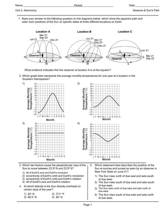
1. Name:_____________________________________________________________
Period:____________ Date:________________
Unit 2: Astronomy Seasons & Sun's Path
1. Base your answer to the following question on the diagrams below, which show the apparent path and
solar noon positions of the Sun on specific dates at three different locations on Earth.
What evidence indicates that the observer at location A is at the equator?
2. Which graph best represents the average monthly temperatures for one year at a location in the
Southern Hemisphere?
1) 2)
3) 4)
3. Which two factors cause the perpendicular rays of the 5. Which statement best describes the position of the
Sun to move between 23.5º N and 23.5º S? Sun at sunrise and sunset as seen by an observer in
1) tilt of Earth's axis and Earth's revolution New York State on June 21?
2) eccentricity of Earth's orbit and Earth's revolution 1) The Sun rises north of due east and sets south
3) eccentricity of Earth's orbit and Earth's rotation of due west.
4) tilt of Earth's axis and Earth's rotation 2) The Sun rises south of due east and sets south
4. At which latitude is the Sun directly overhead on of due west.
certain days of the year? 3) The Sun rises north of due east and sets north of
due west.
1) 42° N 2) 23.5 ° N 4) The Sun rises south of due east and sets north
3) 66.5° N 4) 90° N of due west.
Page 1
2. 6. Base your answer to the following question on on the diagram below, which shows the parts of Earth
experiencing daylight and darkness as Earth orbits the Sun. Letters A, B, C, D, and E are positions in
Earth's orbit as viewed from above the Northern Hemisphere.
On the grid, place Xs to show the duration of insolation at the
Arctic Circle (66.5º N) as Earth orbits the Sun at positions A, B, C, and D. Connect the Xs with a line.
7. Which motion causes the constellation Orion to be
visible at midnight from New York State in winter but
not in summer?
1) revolution of Orion 2) rotation of Orion
3) revolution of Earth 4) rotation of Earth
8. If the axis of Earth were not tilted relative to the plane
of its orbit around the Sun, the result would be
1) a reversal of polar and equatorial climates
2) an equal number of hours of daylight at most
locations
3) a greater number of hours in a day
4) a greater number of days in a year
Page 2
3. 9. A student in New York State looked toward the eastern horizon to observe sunrise at three different
times during the year. The student drew the following diagram that shows the positions of sunrise, A, B,
and C, during this one-year period.
Which list correctly pairs the location of sunrise to the time of the year?
1) A—December 21
B—March 21
C—June 21
2) A—June 21
B—December 21
C—March 21
3) A—March 21
B—June 21
C—December 21
4) A—June 21
B—March 21
C—December 21
10. Base your answer to the following question on the 11. The diagram below shows the shadow cast by a
diagram below which shows twelve constellations that telephone pole on March 21 at solar noon at a
are visible in the night sky to an observer in New location in New York State.
Jersey, over the course of a year. Different positions of
Earth are represented by letters A through D. The
arrows represent the direction of Earth's motion
around the Sun.
Which shadow was cast by the same telephone pole
on June 21 at solar noon?
1) 2)
Which constellations are both visible at midnight to
an observer in New Jersey when Earth is located at
position D?
1) Aries and Taurus
2) Pisces and Libra
3) Aquarius and Scorpio 3) 4)
4) Leo and Virgo
Page 3
4. Base your answer to questions 12 and 13 the graph below, which shows the duration of daylight hours
on
throughout the year for five cities located in the Northern Hemisphere.
12. hich city experiences the greatest variation in daylight hours during one year?
W
1) Caracas 2) New Orleans 3) Mexico City 4) Edmonton
13. hat is the primary reason each city’s duration of daylight hours changes throughout the year?
W
1) The cities are located at different longitudes.
2) The cities are located at different elevations.
3) Earth’s rotation rate is 15° per day.
4) Earth’s axis is tilted 23.5 ° to the plane of its orbit.
14. Base your answer to the following question on the diagram below, which represents Earth in its orbit
around the Sun. The position of Earth on the first day of each season is labeled A, B, C, and D.
What is the approximate rate of Earth's revolution around the Sun?
1) 15° per year 2) 15° per day 3) 1 ° per year 4) 1° per day
Page 4
5. 15. Base your answer to the following question on diagram below, which represents the Sun’s apparent
paths and the solar noon positions for an observer at 42 ° N latitude on December 21, September 23,
and June 21.
Which graph best shows the altitude of the Sun, as measured by the observer located at 42 ° N, at
various times on December 21?
1) 2)
3)
4)
Page 5
6. 16. the diagram below, which shows a model of Earth’s orbit around the Sun. Two motions of Earth are
indicated. Distances to the Sun are given for two positions of Earth in its orbit.
Explain why Canada experiences summer when Earth is at its greatest distance from the Sun.
17. The diagram below shows Earth as viewed from space.
Which season is beginning in the Northern Hemisphere?
1) summer 2) winter 3) fall 4) spring
18. The diagram below shows the noontime shadows
cast by a student and a tree.
If the time is solar noon and the student is located in
New York State, in what direction is the student
facing?
1) west 2) south 3) east 4) north
Page 6
7. Base your answer to questions 19 through 21 on the diagram below, which represents Earth revolving
around the Sun. Letters A, B, C, and D represent Earth's location in its orbit on the first day of the four
seasons. NP represents the North Pole.
19. If the tilt of Earth's axis were decreased from 23.5 ° to 15°, New York State's winters would become
1) cooler, and summers would become cooler
2) cooler, and summers would become warmer
3) warmer, and summers would become warmer
4) warmer, and summers would become cooler
20. Which location in Earth's orbit represents the first day of summer in New York State?
1) A 2) B 3) C 4) D
21. Which diagram best represents the Sun's apparent path as seen by an observer at 43.5° N latitude on
December 21?
1) 2)
3) 4)
Page 7
8. 22. Base your answer to the following question on the diagram below, which shows Earth and the Moon in
relation to the Sun. Positions A, B, C, and D show the Moon at specific locations in its orbit. Point X is a
location on Earth's surface.
On what date does the line separating day and night pass through Earth's North Pole, as shown in this
diagram?
1) June 21 2) December 21 3) January 21 4) March 21
23. Which model best represents the apparent path of
the Sun observed at various times during the year at
the Equator?
1)
2)
3)
4)
Page 8
9. 24. Base your answer to the following question on the diagram below, which shows a model of Earth’s
orbit around the Sun. Letters A, B, C, and D represent Earth’s position at the beginning of each
season.
How many degrees will the Sun’s vertical rays shift on Earth’s surface as Earth travels from position C
to position D?
1) 15° 2) 23.5 ° 3) 47° 4) 365°
Page 9
10. 25. Which diagram correctly shows the directions of
Earth's revolution and rotation?
1)
2)
3)
4)
Page 10
11. Answer Key
Seasons and Suns Path Practice Questions
1. — The Sun is 16. • The North Pole is
directly overhead at tilted toward the
solar noon on Sun in the summer.
March 2l. — • In summer, the
The Sun reaches an Sun is higher in the
altitude of 90º on an sky due to the tilt of
equinox. — Earth’s axis.
Each apparent path • New York State
of the Sun has a receives higher
daylight duration of angles of insolation
12 hours. in summer when
2. 4 Earth is farthest
from the Sun.
3. 1
• New York State
4. 2 receives lower
5. 3 angles of insolation
6. in winter when
Earth is closest to
the Sun. •
greater duration of
insolation
17. 2
18. 4
7. 3 19. 4
8. 2 20. 2
9. 4 21. 4
10. 4 22. 4
11. 1 23. 1
12. 4 24. 2
13. 4 25. 4
14. 4
15. 3
Page 11