Tornadoes - Oh My!
•Download as PPTX, PDF•
2 likes•5,260 views

Engage students to be the presenters to explain how tornadoes form, the Enhanced Fujita Scale, and types and shapes of tornadoes.

Recommended
More Related Content
What's hot
What's hot (20)
Similar to Tornadoes - Oh My!
Recently uploaded
Recently uploaded (20)
Tornadoes - Oh My!
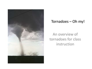
- 1. Tornadoes – Oh my! A slidedeck for student engagement Credit: UCAR Digital Image Library
- 2. Tornado slidedeck overview: • How tornadoes form • Types of tornadoes • The Enhanced Fujita Scale • Tornado Shapes
- 3. Credit: NOAA
- 4. Credit: UCAR
- 5. Credit: UCAR
- 6. Fun Fact: Only about one thunderstorm in a thousand produces tornadoes. Most tornadoes form during rotating supercell thunderstorms that often grow to over 40,000 feet. Credit: UCAR Digital Image Library
- 7. Image from VORTEXT2: http://www.nssl.noaa.gov/projects/vortex2/learn/
- 8. Credit: UCAR
- 10. Can you spot the hook? Credit:NOAA
- 12. How are tornadoes classified? • What are the limitations of using qualitative observations (shape, colors) to classify the strength of a tornado?
- 13. Can you think of a way to quantify the strength of tornadoes? How else can tornadoes be quantified?
- 14. Enhanced Fujita Scale • The Enhanced Fujita scale assigns a tornado “rating” based on estimated wind speeds and related damage • The National Weather Service is the only federal agency with authority to provide “official” tornado EF Scale ratings
- 15. The Enhanced Fujita Scale The EF Rating is on a scale 0 to 5, depending on the 3 second gust (mph) Ranks 1-28 based on damage indicators (DIs) such as building type, structures, and trees.
- 16. Note: This only shows the first 10 damage indicators of the Enhanced F Scale
- 17. Shapes of tornadoes • Stove-pipe • Dust Column (generally small and weak) • Wedge (Large and fierce) • Rope
- 19. Dust Column Tornado (F0-F1) Credit:UCARDigitalImageLibrary
- 20. Dust Column Tornado (F0-F1) Credit:UCARDigitalImageLibrary
- 25. Credit: UCAR Digital Image Library
Editor's Notes
- In A, you can see the rotating air can form where winds at different altitudes blow at different speeds, creating wind shear. In this example, a low wind blows at five mph and a high wind blows at 25 miles per hour. In B, the yellow arrow shows the direction of the moving air. If the rotating air gets caught in the flow of air moving up into the storm (an updraft), the spin tightens and speeds up, creating a funnel cloud. In C, the yellow arrow shows where the air from B moves through the cloud. The rain and hail in the thunderstorm cause the funnel to bend downward. If it touches the ground, it’s a tornado. https://scied.ucar.edu/imagecontent/how-tornadoes-form
- Tornadoes frequently form when there is a warm air close to the ground and a fast approaching cold air system that interacts with the warm air.
- Only about one thunderstorm in a thousand produces tornadoes. Most tornadoes form during rotating supercell thunderstorms that often grow to over 40,000 feet. More information about supercells:
- This is a diagram of the separate updraft and downdraft that allow a mesocyclone to occur in supercell thunderstorms.
- Supercell thunderstorms occur when very strong updrafts are balanced by downdrafts. This can allow the storm to persist for many hours. In a supercell, a moist, unstable body of warm air may be forced to rise by an approaching cold front. More information about temperature: http://eo.ucar.edu/webweather/thunder2.html (UCAR Center for Science Education) http://www.eo.ucar.edu/kids/dangerwx/tornado3.htm
- When viewed from the top (right image), the counter-clockwise rotation of the mesocyclone gives the supercell its classic "hook" appearance when seen by radar. As the air rises in the storm, it becomes stretched and more narrow with time. http://www.srh.noaa.gov/jetstream/tstorms/tornado.htm
- The image (below right) is from the Doppler radar in Springfield, Missouri, May 22, 2011. This image was taken at 5:43 p.m., as a strong tornado moved through Joplin, Missouri. The colors indicate the intensity of the rain with green representing light rain, the yellow and orange for moderate rain and reds and fuchsia for the heaviest rain and hail. The classic "hook" pattern of the supercell from which a tornado was observed can be clearly seen. Questions: Can you identify patterns in amounts of rainfall based on the diagram (e.g. lightest rain along the outside of the storm, most intense rain in the middle of the storm)? Where is the hook of the tornado?
- http://www.nws.noaa.gov/om/severeweather/resources/ttl6-10.pdf
- Additional background information: (NOAA: http://www.srh.noaa.gov/jetstream/tstorms/tornado.htm) The Fujita (F) Scale was originally developed by Dr. Tetsuya Theodore Fujita to estimate tornado wind speeds based on damage left behind by a tornado. An Enhanced Fujita (EF) Scale, developed by a forum of nationally renowned meteorologists and wind engineers, makes improvements to the original F scale. This EF Scale has replaced the original F scale, which has been used to assign tornado ratings since 1971. The original F scale had limitations, such as a lack of damage indicators, no account for construction quality and variability, and no definitive correlation between damage and wind speed. These limitations may have led to some tornadoes being rated in an inconsistent manner and, in some cases, an overestimate of tornado wind speeds. The EF Scale takes into account more variables than the original F Scale did when assigning a wind speed rating to a tornado. The EF Scale incorporates 28 damage indicators (DIs) such as building type, structures, and trees. For each damage indicator, there are 8 degrees of damage (DOD) ranging from the beginning of visible damage to complete destruction of the damage indicator. The original F Scale did not take these details into account. Owlie Skywarn: Tornado Safety Book (pdf) For example, with the EF Scale, an F3 tornado will have estimated wind speeds between 136 and 165 mph (218 and 266 km/h), whereas with the original F Scale, an F3 tornado has winds estimated between 162-209 mph (254-332 km/h). The wind speeds necessary to cause "F3" damage are not as high as once thought and this may have led to an overestimation of some tornado wind speeds. There is still some uncertainty as to the upper limits of the strongest tornadoes so F5 ratings do not have a wind speed range. Wind speed estimations for F5 tornadoes are left open ended and assigned wind speeds greater than 200 mph (322 km/h).
- Resource: http://www.srh.noaa.gov/oun/?n=efscale
- Reference: http://www.srh.noaa.gov/oun/?n=efscale
- Stovepipe: This tornado looks like a tube reaching from cloud to ground. It is straight up and down like a pipe or tipped to the side and narrow, but it may widen and become a wedge.
- Stovepipe: This tornado looks like a tube reaching from cloud to ground. It is straight up and down like a pipe or tipped to the side and narrow, but it may widen and become a wedge. NCAR Digital Image Library