The Visayan Island
•Download as PPTX, PDF•
4 likes•3,465 views

BEED-CE II SUMMER Presentation

Recommended
More Related Content
What's hot
What's hot (20)
Similar to The Visayan Island
Similar to The Visayan Island (20)
More from Shin Tampus
More from Shin Tampus (20)
Recently uploaded
Recently uploaded (20)
The Visayan Island
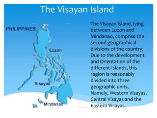
- 1. The Visayan Island The Visayan Island, lying between Luzon and Mindanao, comprise the second geographical divisions of the country. Due to the development and Orientation of the different Islands, this region is reasonably divided into three geographic units, Namely, Western Visayas, Central Visayas and the Eastern Visayas.
- 10. Physical Environment: The first four provinces are found in the Island of Panay. The sixth largest Island, which shown roughly the shape of an equilateral triangle. The three district topographic features are: the western upland, which form the eastern boundary of the province of Antique; the Central lowland, which is partly intermountain and partly coastal in character; and lastly, the Eastern upland, which follow a Northeast-Southeast direction extending for about 56 kilometer. Guimaras, a sub-province of Iloilo. Negros Occidental has a narrow coastal plain in its Western portion facing Guimaras Island.
- 11. Climate in Panay Western portion of Panay has a wet and dry season lasting for 6months each, while the Eastern portion has a shorter period of dry season.
- 14. The inhabitants of Panay and Negros Occidental speak a common Visayan dialect, Hiligaynon.
- 15. Cultural Aspect The port of Iloilo services a very rich sugar and fish producing hinterland in the Island of Panay.
- 21. Physical Environment The unique position places this region midway between Palawan and Samar. Siquijor Island which was once a sub-province of Negros Oriental has rolling hills at the Central portion and narrow coastal plain around the Island.
- 22. Agriculture, forestry and as well as manufacturing are the principal economic activities of the region.
- 23. Economic Resources The coastal plains of Oriental Negros are composed of water deposited volcanic materials brought down from the central highlands and favorable for sugarcane production. Negros Oriental is the most thickly forest among the provinces of the region. Cebu is the most intensively cultivated island to meet the needs of its dense population.
- 24. The strategic location of Central Visayas in the Philippines has made Metropolitan Cebu which is the regional center, and industrial, commercial, financial, transportation and educational center of the Visayas-Mindanao area.
- 25. The inhabits of Central Visayas speak a common language, the Cebuano-Visayan dialect.
- 26. The best fishing grounds of the province are found around Bantayan Island.
- 27. Cultural Aspect Cebu is one of the most thickly populated region of the country. Cebu was dubbed as the “Queen City of the South”. As an educational center-Cebu City is the seat of the universities like the University of San Carlos, University of the Philippines, Cebu College, University of the Visayas and University of Southern Philippines. Dumaguete City, the capital of Negros Oriental is the principal commercial and educational center of the province,.
- 28. Universities University of San Carlos, University of the Philippines, Cebu College, University of the Visayas and University of Southern Philippines.
- 36. Physical Environment The provinces of Samar taken collectively comprise the Island of Samar which is the third largest while Leyte is the eight largest Island of the country. Samar is more of hilly country rather than a mountainous one.
- 37. Economic Resources The North Eastern port of Leyte is more fitted for agricultural production as it is made up of all vial soil. Samar is even less developed than Leyte. It is poor system of transportation and exposure to frequent typhoons are the principal deterrent factors.
- 38. Major Food Crops
- 39. Most important commercial crops
- 40. Cultural Aspects The regional ties between Leyte and Samar are enhanced by the sharing of a common Samar- Leyte (waray-waray) ethnolinguistic culture.
- 42. Tacloban City The capital of Leyte and the Regional centre, dominates the trade and financial activities of the region.
- 43. Ormoc City The centre of commerce and industry on the western part of Leyte.
- 44. Calbayog City Located on the coast of Western Samar, facing the Samar sea, is the trading and commercial centre of the province.
- 45. Ann Dieben Machete Mary Grace Quillo Evie Casinillo Prepared By