
Recommended
More Related Content
What's hot
What's hot (20)
Similar to The Charming Cordillera Region: A Guide to its Beauty and Culture
Similar to The Charming Cordillera Region: A Guide to its Beauty and Culture (20)
Recently uploaded
Recently uploaded (20)
The Charming Cordillera Region: A Guide to its Beauty and Culture
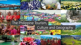
- 1. The Philippine Tourism, Culture and Geography
- 3. • The main city in the Cordillera Administrative Region is Baguio City, The Summer Capital of the Philippines. • Traveling to Baguio City will take you about 35 minutes by plane and 6 hours by bus both from Manila. Cordillera Administrative Region How to get there
- 4. • It is located in the North-Central part of Luzon and encompasses most of the areas within the Cordillera Central mountain range of Luzon. It is bounded by Ilocos Norte and Cagayan in the North, Pangasinan and Nueva Vizcaya in the South, Cagayan Valley in the East, and the Ilocos Region in the West. • It is the country's only land-locked region. It has a mountainous topography and dubbed as the "Watershed Cradle of North Luzon" as it hosts nine major rivers that provide continuous water for irrigation and energy for Northern Luzon. Cordillera Administrative Region Area and Location
- 5. Cordillera Administrative Region Geographical Profile Province/City Land Area (km²) Density (per km²) Abra 3,975.6 52.7 Apayao 3,927.9 24.7 Benguet 2,599.4 127.0 Ifugao 2,517.8 64.2 Kalinga 3,119.7 55.8 Mountain Province 2,097.3 67.0
- 6. Cordillera Administrative Region History • The Cordillera Administrative Region was established on July 15, 1987 through Executive Order No. 220 issued by President Corazon Aquino. • It comprises the provinces of Abra, Apayao, Benguet, Ifugao, Kalinga, (new) Mountain Province and the chartered city of Baguio • The provinces of Kalinga and Apayao are combined to form the sub-province of Kalinga-Apayao. • With the signing into law of Republic Act No. 7878 by President Ramos on February 14, 1995 the province of Kalinga-Apayao was converted into two separate and regular provinces. • The new Mountain Province was then called the sub-province of Bontoc
- 7. Cordillera Administrative Region Political Profile Province City/Municipalities Abra Bangued Apayao Kabugao Benguet La Trinidad Ifugao Lagawe Kalinga Tabuk Mountain Province Bontoc
- 8. Abra Capital: Bangued “Bamboo Capital of the Philippines”
- 9. Abra How to get there The province of Abra can be reached from Manila by bus. From Manila, Abra is roughly 8 hours by bus. Partas, Dominion and Viron Bus have daily trips to Bangued, Abra from Manila. The trip through the mountains can be alarming and spectacular, all part of your journey!
- 10. Abra Geographical Profile, Area and Location Municipalities 27 Barangays 303 Coastal/Landlocked Landlocked Land Area 4,165.25 km 2 (1,608.21 sq mi) Density 58 / km 2 (150 / sq mi) Abra is bordered, clockwise from the North, by Ilocos Norte, Apayao, Kalinga, Mountain Province, and Ilocos Sur.
- 11. Abra People, Dialect Spoken, Population and Religion The Tinggians is a group of indigenous people based in Nortwestern Luzon. They are also called Itneg because they live near the Tineg River. Other terms used for their names are I-tineg, Tinguian, Itinek, Tinguianes, Mandaya and Tingian. They reside in the provinces of Ilocos Sur, Iloilo and greater concentration in Abra. Two Main Groups of Tinggians • The Valley Tinggians • The Mountain Tinggians.
- 12. Abra People, Dialect Spoken, Population and Religion Dialet Spoken: Ilocano, Tinguian, Isneg, Tagalog and English Population (2015): 241,160 Religion: Tinguians are Christians but they have not totally put aside their worship, beliefs and superstitions centering around the "sasailo" concept. They reconcile their traditional faith with Christianity. They believe in one supreme being who creates and controls life. They worship and ask intercession for the religious observances that go with various paraphernalia, bamboo arches, Basi (drink offerings), and musical instruments. Protective necklaces are used by children.
- 13. Abra Products Abra’s major crops are rice, corn, and vegetables, root crops; commercial products include coffee, tobacco, and coconut. Extensive grassland and pasture areas are used for livestock production.
- 14. Abra Cuisine/Delicacy Abuos – is a rare summer delicacy made out of the eggs of big red ants. Paksiw na Palileng – agsimao is very rich in natural resources including this river fish called palileng. They grow in the clean rivers of Tineg abundantly. This home- cooked palileng dish was just an exotic Tineg gastronomic experience.
- 15. Abra Cuisine/Delicacy Abal Abal – looks like a June beetle but its darker. They are found in river banks of Abra during first rains of May and June. Cascaron – is made of sticky rice balls smothered with freshly extracted molasses.
- 16. Abra Music, Dance and Art Diwdiw-as – is a musical instruments of Tinguians in Abra. It is a pan-pipe of five or seven pieces of bamboo reeds of different lengths tied side by side. Idudu – is a tribal dance, dance depicts a day of family life in the Itneg or Tinguian tribe. It tells the story of a father plowing the field as the mother cares for her children. In time, the father and mother exchange duties as the mother finishes planting and other chores in the field, and the father tends to the kids.
- 17. Abra Tourist Attraction Don Mariano Marcos Bridge Sibud-Sibud Cave Piwek Rock Formation Abel Loom Weaving in La Paz Kili Falls & Hot Spring
- 18. Apayao Capital: Kabugao "Cordillera's Last Frontier for Nature Richness."
- 19. Apayao How to get there The only way to get to Apayao Province by land transport. From Manila to Apayao the duration of travel by bus is 11 hours. There is no commercial airport in Apayao Province. The two ways of getting to Apayao by land is either through Cagayan Province to the west or Mountain Province which is also to the west of Apayao Province.
- 20. Apayao Geographical Profile, Area and Location Municipalities 7 Barangays 133 Coastal/Landlocked Landlocked Land Area 4,413.35 km 2 (1,704.00 sq mi) Density 27 / km 2 (70 / sq mi) Apayao is bordered, clockwise from the Northeast, by Cagayan, Kalinga, and Abra, Ilocos Norte.
- 21. Apayao People, Dialect Spoken, Population and Religion The Isneg people are one of the oldest tribes in Philippines. The isneg people have been called many other names. The Spanish called them Los Apayaos or Los Mandayas. They are also known as the Isnag, Isned, Kalina’ and Payao. The name Isneg means people who have gone into the interior. They used to live mostly along large rivers and on hillsides. Now they also live in many cities, mainly in Kalanasan
- 22. Apayao People, Dialect Spoken, Population and Religion Dialect Spoken: Ilocano, Isneg, Tagalog and English Population (2015): 119,184 Religion: Approximately 9% of the population are Christians. Apayao are spirit-filled for they believe in spiritual powers of all sorts. The Isnags’ spirituality is manifested in their belief that God, referred as to Alawagan and other spirits all around, are factors in their abundant environmental resources.
- 23. Apayao Products Apayao is devoted to agricultural production, particularly food and industrial crops such as palay, corn, coffee, root crops and vegetables. Fruits produced include lanzones, citrus, bananas and pineapples, durian, santol, rambutan, coconut and mangosteen. Rice production totaled 98,489 metric tons in 2011.
- 24. Apayao Cuisine/Delicacy Sinandila – is a sticky rice dessert staple on the Isnag dining table. It's wrapped in banana leaves and steamed, often served with a generous drizzle of latik or coconut curds. Duck Pinikpikan – is a common soup dish among the provinces in the Cordillera Region. However, instead of using native chicken, Apayao's version of Pinikpikan found its taste with native ducks. It is much more tastier and gives a much stronger soupy taste according to the locals.
- 25. Apayao Music, Dance and Art • The Tallip is a victory dance for war and headhunting. • The Taddó is performed during thanksgiving ceremonies and courtship. Both involve a lot of feet stomping on a bamboo mat called dalahda, to the rhythmic beating of a gansa drum
- 26. Apayao Tourist Attraction Apayao River Lussok Crystal Cave Dupag Rock Formation Mt. Kilang Banselan Cave
- 27. Benguet Capital: La Trinidad “Strawberry Capital of the Philippines”
- 28. Benguet How to get there You can either fly or go by road. Flying time from Manila to Baguio City, is only 35 minutes so if time is short catch a plane. The other option is to take an air conditioned bus from Manila, it will take about 6 hours.
- 29. Benguet Geographical Profile, Area and Location Municipalities 13 Barangays 140 Coastal/Landlocked Landlocked Land Area 2,769.08 km 2 (1,069.15 sq mi) Density 160 / km2 (415 / sq mi) Benguet is bordered, clockwise from the Northeast, by Mountain Province, Ifugao, Nueva Vizcaya, Pangasinan, La Union, and Ilocos Sur.
- 30. Benguet People, Dialect Spoken, Population and Religion The Ibaloi, also called Nabaloi or Inibaloy, are among the indigenous people collectively known as the Benguet people who occupy the Northern part of Luzon. The name Ibaloi means "people who live in houses.“ Benguet people believe in supreme beings and spirits that guide their way of living as well as their future. Karao tribe lives in the municipality of Bokod, Benguet. The Karaos observe the following social institutions: the family, the abo-nan (a community center), the amang (a sleeping quarter for boys, girls and newlyweds), the cheng ngeg Ni baley (foundation House), and the Chelos (rituals).
- 31. Benguet People, Dialect Spoken, Population and Religion Dialect Spoken: Kankana-ey, Ibaloi, Kalanguya, Bontoc, Ilocano, Tagalog and English Population (2015): 444,224 Religion: The ancient Indigenous People believed in God Almighty - Kabunian. However, some elders and leaders claimed that the indigenous peoples’ belief in Kabunian and ancestor worship is not paganism, but more appropriately, animism, which carried a deep respect for nature and the spirit of the dead. Christianity was introduced through the Spanish missionaries.
- 32. Benguet Products Agriculture, mining, and tourism are the major industries in Benguet. Major crops produced which include potatoes, Baguio beans, peas, strawberries, cabbage, broccoli, cauliflower, lettuce, sayote and carrots are shipped throughout the country. The province supplies flowers to the different municipalities, including Baguio City, as well as to Metro Manila, including other parts of Luzon, Visayas and Mindanao.
- 33. Benguet Cuisine/Delicacy Pinuneg – Cordillera’s version of sausage; except that the contents and covering are different. Pinuneg is a mixture of pig blood and spices wrapped in a clean and empty pig’s large intestines. Watwat – is commonly described as a slice/slices of boiled pork that is distributed or shared as part of the meal of an Igorot feast.
- 34. Benguet Music, Dance and Art Terektek – two terektek woodpeckers vie for the attention of three females. One male woodpecker rhythmically bang on a brass gong to represent a good voice, while other swish about a colorful blanket representing beautiful plumage. Bendayan – a dance to celebrate the arrival of successful headhunters, the Bendayan has taken a new face. It is part of every Benguet festivity with the circles slowly giving way to other formations and interpretations.
- 35. Benguet Tourist Attraction Strawberry Festival Timbac Cave The STOBOSA Hillside Homes Artwork The Flower Farms of Bahong
- 36. Ifugao Capital: Lagawe “Land of the Eighth World Wonder”
- 37. Ifugao How to get there Ifugao Province is just under 350 kilometres from Manila. You can catch a plane to the province of Nueva Viscaya, the land portion of the trip then will only take about 45 minutes to Ifugao Province. Buses from Manila will take about 10 hours, the scenery is nothing short of awesome.
- 38. Ifugao Geographical Profile, Area and Location Municipalities 11 Barangays 175 Coastal/Landlocked Landlocked Land Area 2,628.21 km 2 (1,014.76 sq mi) Density 77 / km 2 (200 / sq mi) Ifugao is bordered, clockwise from the North, by Mountain Province, Isabela, Nueva Vizcaya, and Benguet.
- 39. Ifugao People, Dialect Spoken, Population and Religion Ifugao, group of wet-rice agriculturalists occupying the mountainous area of northern Luzon. The Ifugao live in small hamlets of 5 to 10 houses scattered among the rice terraces. The Kalanguya are an indigenous people group of the northern Philippines. The Kalanguya people often fall “in-between the cracks” of standard classifications of major ethnolinguistic groups of the Philippines. The Kalanguya appear on no travel guides for exotic cultural experiences in the northern Philippines. Kalanguya Ifugao
- 40. Ifugao People, Dialect Spoken, Population and Religion Dialect Spoken: Ifugao, Tawili, Ayangan, Kalanguya, Ilocano, Tagalog and English Population (2015): 202,802 Religion: About half of all Ifugaos have embraced Christianity but their animist beliefs have been absorbed into their Christian beliefs. The Ifugao have traditionally believed their lives were ruled by spirits called anitos.
- 41. Ifugao People, Dialect Spoken, Population and Religion Many Ifugao still believe the universe was divided into five levels. At the top is: 1) the heavens which itself has four "superimposed heavens." Beneath it is 2) Pugao, the known land. Below is 3) the underworld and there is also 4) the world upstream and 5) the world downstream. Each area has a large number of spirits, each of which has a name and belongs to one of 35 categories. Among them are ones associated with hero ancestors, diseases, omens, messengers, celestial bodies.
- 42. Ifugao Products The province is based in agriculture, hunting and forestry. They raise rice, root crops, vegetables, coffee and cotton in the rice terraces or in kaingins
- 43. Ifugao Cuisine/Delicacy Diket Rice Pudding – is a fat sticky rice, light purple in color with a slight barley flavor. This is excellent to use in salads, puddings and all sweet dishes. Inlagim – is a native chicken stew that is used during rituals or celebrations in Ifugao. It is a ginger and onion based soup with chicken as the usual main ingredient.
- 44. Ifugao Music, Dance and Art • Hudhud Is consist of narrative chants traditionally performed by Ifugao community. It is practiced during the rice sowing season, at harvest time and at funeral wakes and rituals. The Hudhud comprises more than 200 chants, each divided into 40 episodes. A complete recitation may last 3 or 4 days. The HUDHUD was also proclaimed by UNESCO as a Masterpiece of the Oral and Intangible Heritage of Humanity, together with many others in the world. It is also considered as one of the 2 Longest Epics in the world. The other one is the Ramayana of India.
- 45. Ifugao Music, Dance and Art Uyaoy/Uyauy – the Ifugao are said to be the “children of the earth.” This Ifugao wedding festival dance is accompanied by gongs and is performed by the affluent to attain the second level of the wealthy class. Bulol – is an Ifugao anthropomorphic carving that symbolizes an Ifugao rice god or guardian spirits, simplified shape of a human being, whether male or female.
- 46. Ifugao Tourist Attraction Bangaan Rice T erraces Kiangan Shrine Batad Amphitheater Terraces Mt. Napulawan (Hungduan) Tenogtog Falls
- 47. Kalinga Capital: Tabuk “White Water Rafting Capital of the North”
- 48. Kalinga How to get there You can fly from Manila to Tuguegarao, which is the capital of Cagayan Province. The flight and subsequent jeepney trip to Tabuk, the capital of Kalinga will take a little over 1 ½ hours. The other option is to bus it from Manila.
- 49. Kalinga Geographical Profile, Area and Location Municipalities 7 Barangays 152 Coastal/Landlocked Landlocked Land Area 3,231.25 km 2 (1,247.59 sq mi) Density 66 / km 2 (170 / sq mi) Kalinga is bordered, clockwise from the North, by Apayao, Cagayan, Isabela, Mountain Province, and Abra.
- 50. Kalinga People, Dialect Spoken, Population and Religion Kalinga is both a tribal community and a landlocked province in the heart of the Cordillera Region. The name Kalinga believed to have originated from the Gaddang and Ibanag languages, means “headhunter.” Kalinga people could be identified from a distance by their distinctive body art. Today Kalinga tattoo art is popular with tourists but scarcely adorns authentic skin. World renowned Apo Whang-Od is the last practicing traditional mambabatok or tattoo artist in the whole region. With her in her nineties, time is running out for her to pass on the time-honored hand tapping technique and tribal motifs to her 13-year-old grand daughter and apprentice. Although locals rarely practice the tattoo tradition today, tourists are currently flocking to Buscalan village to have this living legend scar their skin.
- 51. Kalinga People, Dialect Spoken, Population and Religion Dialect Spoken: Basalangao, Tanudan, Labuagan, Ilocano, Tagalog and English Population (2015): 212,680 Religion: According to the 2000 census, 17.6% of the population of the Cordillera Administrative Region, of which Kalinga province is a part, was classified as "Other" in religious affiliation, meaning adherents of indigenous religion. The rest followed a form of Christianity: 65.8% of the region's population is Roman Catholic, 8.9% Evangelical, 2.9% Iglesia ni Cristo, 1.6% Jehovah's Witness. Kalinga People, Dialect Spoken, Population and Religion
- 52. Kalinga Products Kalinga’s products include food products such as coffee, fruit and rice wine, chilli paste, chilli vinegar, local varieties of indigenous rice, chips made from vegetables, and handicracfts such as handwoven items clothes and garments, bags, decorations, among others.
- 53. Kalinga Cuisine/Delicacy Binungor/binongor, is an original very hot and spicy, Kalinga exotic delicacy that has gained popularity in our province and nearby areas thanks to the booming tourism in Kalinga Province. Zinagan – is a version of Dinuguan: intestines and other pork innards that are fried until the whole thing becomes crispy enough just like chicharon before being sauteed with garlic, onions, ginger and pork blood; better served with sinursur, pinaltit, and sagke
- 54. Kalinga Music, Dance and Art Paldong – is a traditional lip-valley flute of Kalinga Tribes. It is made of bamboo. Its upper edge is cut away obliquely from the backside, and then cut away slightly from the frontside. The player's lower lip is placed against the cut away surface. Kolitong – a bamboo tube, closed at both end by a node. In both nodes a star shaped opening is cut. Five strings are cut loose from the skin, and lifted and tuned with small pieces of wood. The tube is cracked and slightly opened to improve resonance.
- 55. Kalinga Music, Dance and Art Tongali or Kalingga – is a node of bamboo with hole at one end and open at the other. There are three holes on top and one hole underneath. There are incised designs on the body. It is played by putting the blowing end on one nostril. Banga – is a contemporary performance of Kalinga of the Mountain Province. It illustrates the languid grace of a tribe otherwise known as fierce warriors.
- 56. Kalinga Music, Dance and Art Lumagen/Tachok – danced by the Kalinga maiden. The dance imitates birds flying in the air. Music is provided by gangsa, or gongs, which are usually in a group of six or more. Pagbabatok – is practiced by hand- tapping the ink into the skin using a thorn attached to one end of a stick. The thorn used is usually from a lemon plant and is called “Sait” in their dialect
- 57. Kalinga Tourist Attraction Tinglayan Rice Terraces Binasalan Falls Sulfur Hill Mt. Mating-oy Buaya Caves
- 58. Mountain Province Capital: Bontoc “Weaver’s Paradise”
- 59. Mountain Province How to get there Getting to Bondoc in Mountain Province from Manila is a long bus trip. Taking the bus from Manila Pasay to Baguio and then taking the taxi from Baguio to Mountain Province, which takes around 9h 44m. The trip will take you through Baguio City and then through the Halaema Mountain Highway to Bontoc. Once in Bontoc only jeeps will take you the 4 hour trip to Sagada.
- 60. Mountain Province Geographical Profile, Area and Location Municipalities 10 Barangays 144 Coastal/Landlocked Landlocked Land Area 2,157.38 km 2 (832.97 sq mi) Density 72 / km 2 (186 / sq mi) Mountain Province is bordered, clockwise from the North, by Kalinga, Isabela, Ifugao, Benguet, Ilocos Sur, and Abra.
- 61. Mountain Province People, Dialect Spoken, Population and Religion Bontoc comes from the word buntuk, which means mountains and refers to the people of Mountain Province. The Bontoc tribes people were animists who had refused conversion during the Spanish times. Both men and women traditionally covered their bodies with tattoos, although the men were only allowed to after having killed enemies in inter-tribal conflicts. Women wear bright red hand-woven skirts, and used distinctive pieces of snake skeleton as hairpieces. Today, many of the Bontoc cultures and traditions are rarely practiced and slowly disappearing.
- 62. Mountain Province People, Dialect Spoken, Population and Religion Dialect Spoken: Ilocano, Bontoc, Kankana-ey, Tagalog and English Population (2015): 154,590 Religion: Traditional religion remains strong among the Bontoc, especially spirits associated with the dead. These spirits, known as anito, live in a spirit world in the mountains that is not unlike the one people live in. They are consulted on all characterized matters and relay their answers through bird calls. Lumawig is the supreme deity. The patay are hereditary clan of preachers who conduct ceremonies to honor Lumawig.
- 63. Mountain Province Products Mountain Province is a Weavers’ Paradise. Finely woven products include the traditional tapis for women’s apparel and the traditional wanes (G-string) for men. These products have designs of lizards, diamonds, and eyes. Other woven products are bags, purses, pouches, wallets, blazers, skirts, and wall decors. Weavers are found all over the ten towns of Mountain Province especially in Bontoc, Sagada, Besao, Sabangan, Sadanga, Barlig, Natonin, Paracelis, Tadian, Bauko with different designs and highlighted colors.
- 64. Mountain Province Cuisine/Delicacy Etag – also known as “Igorot smoked meat,” “smoked mountain ham” or “smoked bacon” is salted pork, regarded as part of the life of a Cordilleran from the time of birth until death. Heirloom – is a violet sticky rice (locally known as Ominio) from the Mountain Province.
- 65. Mountain Province Music, Dance and Art Ballangbang/Tallibeng – the most common of all the dances, ballangbang requires the participation of many to beat the gongs and many women dancers. This originated from the western municipalities of Mountain Province. Takik – is a wedding dance identified with the Aplais of western Mountain Province. There are six players to complete the set, each producing a certain beating to produce harmony. The striking of the solibao (ethnic drum) is the guide of the players. The drummer squats and strikes the solibao alternately with his left and right hand. Mountain Province Music, Dance and Art
- 66. Mountain Province Music, Dance and Art Chagchaku – a song or chant to the dead, sung purely vocal, spontaneously composed in a story telling prose where words are led by one elder and being followed into a chorus to the end of the sentence/song. This is done during the waking nights/ days of the vigil. This is to give respect to the dead and keep the time and people awake during the vigil.
- 67. Mountain Province Tourist Attraction Hanging Coffin Lumiang Burial Cave Sumaguing Cave Bontoc Museum Maligcong Rice Terraces
Editor's Notes
- Landlocked – the land is surrounded by other land and it has no shore or anything else landlock means not a lot of water but surrounded by mountains. Topography - is the study and description of the physical features of an area
- Also the “Bamboo Capital of the Philippines”
- Traditional religion is based on beliefs in the spirits or anitos, locally called "sasailo" who are natural deities, leader spirits (good or bad), and ancestral spirits.
- Don Mariano Marcos Bridge Spanning over the mighty Abra River, the Don Mariano Marcos Bridge is the 3rd longest bridge in the Philippines. Stop over for scenic views of the riverbanks and mountainscape. Sibud-Sibud Cave Sibud-Sibud Cave in the province of Abra in Luzon has been recently classified as a Class III cave and placed under the protection and management of the Philippines’ Department of Environment and Natural Resources (DENR). This means that inexperienced cavers can come visit, as long as they are accompanied by experts. Abel Loom Weaving in La Paz The town of La Paz is home to a traditional loom weaving industry specialized in producing fine woven fabrics called abel. These textiles are hand loomed by women of the village who have learned the craft from their mothers and grandmothers. Piwek Rock Formation This natural beauty can be found farther down the road from Apao Rolling Hills. The highlights here are gleaming white limestone rock formations that wall the banks of the Tineg River. Kili Falls & Hot Spring Kili Falls is one of many beautiful places in Abra that you can visit all year round. The main attraction here is not just the waterfall. Hidden behind the main cascade is a hot spring that flows into an icy-cold river.
- Apayao River It passes through two regions: the Cordillera Autonomous Region (CAR) and the Cagayan Valley Region. The powerful river originates from a vast natural watershed located at the western side of the Cordillera Mountain Range and travels through the center of Apayao, passing through the towns of Calanasan, Kabugao, Luna, Pudiol, Flora, and Coner until it reaches the coastal town of Abulug in Cagayan. At that point, the river meets the Pacific Ocean. Lussok Crystal Cave Lussok Cave has metamorphosed into one of Luna's most well-loved attractions. The tour starts with a brief 200-meter boat ride on the enchanting azure waters. Upon entering the cave, glimmering limestone formations loom over the pitch black river. Faint streaks of sunlight seep from a hole, or lussok in their vernacular, caused by war bombings further down the route. Dupag Rock Formation This is a cluster of jagged limestone boulders at barangay Marag. The boulders measure around 7 to 8 feet high. The highest peak is known as Father Rock. It provides an entrancing view of the surrounding fields, valleys, forests, and rivers. The suitable topography of Dupag rock made it a hiding place of the locals and insurgents during the wars and uprisings. It, therefore, plays a major historical role in the area. Mt. Kilang Mt. Kilang rises to more than 1, 656 meters above sea level (MASL). This makes it one of the highest peaks of Northern Apayao. It can be viewed from the boundary of both Apayao and Ilocos Norte. The best time to view its majesty is from 4 am to 5 am. The trek takes hours from the usual trailheads. However, clear sunny days would reward you with breathtaking views of the vast forests of Apayao and the mountain ranges of Ilocos. Sea of cloud formations also frequently appear. Banselan Cave Banselan Cave is one of the most famous tourist spots in the municipality and Apayao as a whole.
- Mount Pulag – Sea of Clouds The natives say that Mt. Pulag is the “playground of the gods.” It has the highest peak in Luzon and is the third highest mountain in the Philippines. Strawberry Festival A month-long festivity held in the month of March marked by various activities such as the agro-industrial fair, vegetable run, search for Miss Strawberry, strawberry eating contest, cultural presentations and highlighted by the Giant Strawberry Butter Cake. Timbac Cave There the mummies stay in Timbac caves, still curled in their original coffins. Scientists believe these mummies were first created sometime by the Ibaloi tribe between 1200 and 1500 CE. Mummification began shortly before a person died, where they would ingest a very salty drink. After death, the body was washed and set over a fire in a seated position, thus drying the fluids. Tobacco smoke was blown into the mouth to dry the inside of the body and internal organs. Finally, herbs were rubbed on the body. It’s estimated that the entire process could take weeks, sometimes months, to finish. They were then buried in the caves. The practice died out in the 1500s when Spain colonized the Philippines. The STOBOSA Hillside Homes Artwork The place is collectively known as Stobosa, an acronym for the sitios of Stonehill, Botiw-tiw and Sadjap in Barangay Balili of Benguet’s capital La Trinidad. In 2016, the Department of Tourism, Local Government of La Trinidad and Davies Paints transformed the place into the Philippines’ first and largest community artwork inspired by the Favelas of Rio de Janeiro in Brazil and Gamcheon Cultural Village of Busan in South Korea. The project is a component of the DOT-Cordillera Administrative Region’s Rev-Bloom (Rev-up, Revive, Revisit, Revitalize) Urban Redevelopment Tourism Program.
- Bangaan Rice Terraces This is one of the five rice terraces of Ifugao listed in the UNESCO World Heritage Sites. While it is less popular, it stands out as the most accessible. It also offers a more rustic setting since there are only a few families living here. Kiangan Shrine The Kiangan National Shrine (Filipino: Bantayog sa Kiangan) also known as the Yamashita Shrine[1] is a war memorial in Kiangan, Ifugao, Philippines. which commemorates the surrender the top commander of Japanese Imperial Army in the Philippines, General Tomoyuki Yamashita to the Allied forces which led to the end of the Japanese occupation of the archipelago during the World War II era. Batad Amphitheater Terraces (Banaue) This is an easily recognizable tourist spot in Ifugao. From the vantage viewpoint, the terraces look like a cascading waterfall. One could just imagine how the Ifugao’s ancestors were able to build such an earthen structure using only wooden tools and stones. Mt. Napulawan (Hungduan), Ifugao Mt. Napulawan projects one of the most fascinating views in Ifugao. It rises to more than 2,642 meters above sea level. Mt. Napulawan is derived from the Ifugao term, “Tuwale,” which literally means, white. Perhaps, this is because of the cloud and fog which perpetually cover the mountain. Locals also say that Bibiyo ( a fairy) guard the mountain. Tenogtog Falls The falls is unique for its dynamic flow. According to locals, Tenogtog is an Ifugao word which means, “chopped.” The falls is named as such because this is where hunters used to chop the meat of deer or wild pigs. Interestingly, they share the chopped meat to passersby.
- Lumiang Burial Cave The Lumiang Burial Cave is probably the most visited burial site in Sagada primarily because it is usually bundled with the Sumaguing Cave Tour. Sumaguing Cave is arguably the town’s most popular tourist attraction and those who avail of the tour are given a free side trip to the Lumiang Cave. Sumaguing Cave Sumaguing Cave is the deepest cave in the Philippines with a depth of more than 500 feet. Sumaguing Cave has the largest chamber connecting all the 60 caves of the town. It is also known as the Big Cave. It is the most popular and most visited site in Sagada. Stalagmites and stalactites form inside the caves over millions of years and are truly a sight to behold.