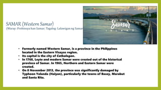
REGION VIII
EASTERN VISAYAS
EasternVisayas(Waray: Sinirangan Kabisay-an; Cebuano: Sidlakang
Kabisay-an; Tagalog: Silangang Kabisayaan or Silangang Visayas) is
an administrative region in the Philippines, designated as Region
VIII. It consists of three main islands, Samar, Leyte and Biliran. The
region has six provinces, Biliran, Leyte, Eastern Samar, Samar,
Northern Samar, and Southern Leyte.
Eastern Visayas faces the Philippine Sea to the east. The region's
most famous landmark is the San Juanico Bridge, which links the
provinces of Samar and Leyte. As of 2020, the Eastern Visayas
region has a population of 4,547,150 inhabitants, making it the
third most populous region in the Visayas.
BILIRAN
Biliran, officially the Province of Biliran is one of the country's smallest and newest provinces.
Formerly a sub-province of Leyte, it became an independent province in 1992.
Biliran lies less than a kilometer north of the island of Leyte. A bridge-causeway fixed link over Poro
Island in the gateway town of Biliran connects the province to Leyte.
Its capital is the municipality of Naval on the western coast of the island.
The fourth smallest province in the Philippines.
*The Climate In Biliran Is Hot, Oppressive, Windy, and Overcast.
Over the course of the year, the temperature typically varies from 75°F To 90°F and is rarely below
73°F or above 93°F.
*The Best Time Of Year To Visit Biliran For Hot-Weather Activities is from Mid January To Mid April.
• DEMOGRAPHICS
• The province has a land area of 536.01 square
kilometers or 206.95 square miles. Its population
as determined by the 2020 Census was 179,312.
• Municipalities: 8
• Barangays: 132
• Marine waterbodies: Samar Sea
• Area (2013): 536.01 km2 (206.95 sq mi)
• Density (2020): 335 / km2 (866 / sq mi)
HISTORY
The early Spanish era, Biliran Island was
known as Isla de Panamao. The term
refers to an ethnic fishing net. The present
name, adopted sometime between 17th
and early 18th century, was derived from a
native grass called Borobiliran which grew
abundantly in the island’s plains. The first
town named Biliran, was founded in 1712.
During this time, the island was a part of
Cebu Province. On April 8, 1959, Republic
Act No. 2141 was signed into law making
Biliran a sub-province of Leyte.
AGRICULTURE
Biliran’s economy is predominantly agricultural. The total agricultural
production area is 30,628 ha. or roughly 55% of the total land area of the
province. In 1998, approximately 100 mt. of various agricultural products
were produced.
Fishery. Municipal fishing accounted for 4,730 mt. of fish produced in 1998.
There are 105 ha. available for brackishwater fishponds but only 50 ha. are
developed. Total fishpond production was 87.6 mt. of prawns, shrimps and
milkfish. Some 55 commercial and 2,712 municipal fishing boats operate in
the territorial waters of the island province. About 30 hectares may be used
for seaweed farming and 10 hectares for fish-cage culture.
• FESTIVAL
May: Hudyaka: One of the highlights of Biliran Provincehood Anniversary on every 11th of
May, the festival is a celebration of the Biliranons’ endeavors as one people with “hudyaka”
or merriment.
DELICACIES
Tourist Destination in Biliran
1. CaucabRiceTerracesinAlmeria 2. TinagoFallsinCaibiran
Tinago Falls is one of the
best attractions offered by
the province of Biliran. It is
simply a hidden paradise
worth discovering. The
name “Tinago” is a Visayan
term for “hidden” which fits
the place. The hypnotic
waterfall blends perfectly
with nature as its cold
waters cascade beautifully
in breathtaking scenery.
Other waterfalls that can
be found in Biliran are
Casiawan Falls in
Cabucgayan; Bagongbong
Falls and Ulan-Ulan Falls in
Almeria.
3. MainitHot SpringinCaibiran
4. SambawanIsland of Maripipi
This island-paradise is dubbed as the
“Undiscovered Paradise” of Biliran.
Sambawan Islands have two islets
connected by boulders. During high tide, it
transforms into three islets. It is blessed
with crystalline waters with beautiful
white-sand beach. The island is also rich
in marine diversity making it a good dive
site. The mountainous coastline provides
tourist a jaw-dropping view of the island.
EASTERN SAMAR
(Waray-Waray: Sinirangan Samar; Tagalog: Silangang Samar)
• Its capital is the city of Borongan.
• Eastern Samar, as a province, was created from Samar
province through Republic Act No. 4221 on June 19, 1965.
• Eastern Samar occupies the eastern portion of the island of Samar.
• Being on the east coast, the province boasts spectacular high waves from
the Pacific Ocean making it ideal for surfing. Every year, Calicoan Island
become the staging ground for an international surfing circuit
competition.
*Best time to visit Eastern Samar
For visiting Eastern Samar, the best time to visit is February and April
through October. In this period you have a warm temperature and little
precipitation. The highest average temperature in the Eastern Samar
region is 31°C in June and the lowest is 27°C in January.
HISTORY
Colonial period
• During his circumnavigation of
the globe, Ferdinand Magellan
had set foot on the tiny island of
of Homonhon in the southern
part of the province. On March
16, 1521, the area of what is now
now Eastern Samar is said to be
the first Philippine landmass
spotted by Magellan and his
crew.
DEMOGRAPHICS
*Eastern Samar covers a total area of 4,660.47
square kilometres (1,799.42 sq mi) occupying the
eastern section and majority of southern Samar's
coast of Samar island in the Eastern Visayas region.
*City: 1
*Municipalities: 22
*Barangays: 597
• AGRICULTURE
• About 95% of the total agricultural land or 225,896 hectares are
croplands which are composed mostly of commercial crops such as
coconut, abaca, banana and pineapple. One fourth of these
or 56,474 hectares, are intended for food crops such as root crops
palay.
FESTIVAL
PADUL-ONG FESTIVAL
Pig Lechon Festival
Held every September 8th
Borongan City Native
DELICACIES
Salukara Lechon
Tourist Destination in Eastern Samar
1. Calicoan Beach 2. Linao Cave
3. Pearl Island 4. Homonhon Island
5. Divinubo Island 6. Ban-awan Falls
LEYTE
• Is an island in the Visayas group of islands in the Philippines. It is eighth-
largest and sixth-most populous island in the Philippines, with a total
population of 2,626,970 as of 2020 census.
• Its capital is the city of Tacloban.
• Politically, the island is divided into two provinces: (Northern) Leyte and
Southern Leyte. Territorially, Southern Leyte includes the island of Panaon to
south. To the north of Leyte is the island province of Biliran, a former sub-
province of Leyte.
• Leyte today is notable for the geothermal electric power plants near Ormoc.
• The best time to visit Leyte, Philippines is February through September. In
this period you have a warm temperature and little precipitation. On the
island of Leyte, the warmest month is May with 31°C and the coldest is
January with 28°C.
HISTORY
• The island was known to 16th-century Spanish
explorers as Tandaya. Its population grew rapidly after
1900, especially in the Leyte and Ormoc valleys. The
island was once the location of Mairete, a historic
community which was ruled by Datu Ete. Before being
colonized by Spain, the island was once home to
indigenous animist Warays to the east and other
indigenous animist Visayan groups to the west. Leyte is
most famous for its role in the reconquest of the
Philippines in World War II. On 20 October 1944, General
Douglas MacArthur waded ashore on Leyte, saying, "I
have returned", but the Japanese did not give up so
easily, as the ensuing Battle of Leyte proved. The
convergence of naval forces resulted in the four-day
Battle of Leyte Gulf, the largest naval battle in history.
During World War II the island was part of a large US
Navy base Leyte-Samar Naval Base.
DEMOGRAPHICS
*The province has a land area of
6,335.44 square kilometers or 2,446.13
square miles.
*Its population as determined by the
2020 Census was 2,626,970 (2020).
*City: 2
*Municipalities: 40
*Barangays: 1,503
*Density: 324.2/km2 (839.7/sq mi)
AGRICULTURE
The major sources of income in the province are farming
and fishing. The major crops grown are coconut, rice,
banana, rice, root crops, fruits, and vegetables. Livestock
and poultry are mostly raised in the backyard, and are used
for home consumption and special occasions.
FESTIVAL
Pintados-Kasadyaan Festival
DELICACIES
Moron Binagol Roscas
Suman Latik Bukayo
Tourist Destination in Leyte
1. Kalanggaman Island 2. Cuatro Islas
3. Canigao Island 4. San Juanico Bridge
5. Alto Peak (Mt. Aminduen) 6. MacArthur Landing Memorial National Park
7. Sabang Daguitan Surf Camp 8. MahagnaoVolcano Natural Park
NORTHERN SAMAR
(Waray: Amihanan Samar/Norte san Samar; Tagalog: Hilagang Samar)
• Is a province in the Philippines located in the Eastern Visayas region.
• Its capital is Catarman and is located at the northern portion of the island of Samar. Bordering
the province to the south are the provinces of Samar and Eastern Samar.To the northwest,
across the San Bernardino Strait is Sorsogon; to the east is the Philippine Sea and to the west is
Samar Sea.
• Northern Samar is famous for its natural rock formations found in Biri Island and white silky sand
beaches in San Jose and Lavezares.
• The best time to visit Northern Samar is from February to June, when the water is calmer.The
most appropriate clothing in this province is casual light clothing: shorts, t-shirt, sandals. Light
jacket and pants at night, at higher elevations, and boating.The rainiest months are October to
January, while the driest is the month of May.
HISTORY
Northern Samar is one of the three Samar provinces created on
June 19, 1965 by virtue of Republic Act No. 4221. The province
is relatively young but it has vital religious and historical
significance. The small island of Capul was the capital of the
province of Samar in 1848-1852. Capul was formerly named
Abak after the ancient ruler of Java who brought the first
settlers to the enchanting island. In the latter period of the
16th century, it was among the first places to be evangelized by
the Spaniards (1596).
Prior to the coming of the Spaniards in 1596, Samar Island was
called in different names (Samal, Ibabao/Cibabao, Tandaya,
etc.). Legend says that when the Spaniards arrived in
Homonhon Island, they met a wounded man and asked the
name of the place, he replied "samad" which implies of what
had happened to him for he didn't understand Spanish. So, the
word "samad" was adopted with an alteration in the last letter
(from d to r). The name Samar was derived from the local
dialect "Samad", meaning wound or cut, which aptly describes
the rough physical features of the island that is rugged and
deeply dissected by streams or a multitude of rivers dissect the
island in various directions like crease-crossing wounds.
DEMOGRAPHICS
TYPE: Province
Island Group: Visayas
Region: Eastern Visayas ( Region
Vlll)
Cities: 0
Municipalities: 24
Baranggays: 569
Coastal/ landlocked: Coastal
Marine waterbodies : Philippine Sea,
Samar
Sea, San
Bernardino Straight
Area ( 2023) : 3,694.96km'2 ( 1,
426.63 sq mi)
Population: 639, 186
Density: 173/km'² ( 448/sq
mi)
The waray people form the majority of the population in the Eastern Samar, Samar, Northern
Samar, Samar, while they form a significant population in Leyte , Southern Leyte, Biliran, and
Sorsogon.
DELICACIES
FESTIVAL
• Embajada Festival
Is celebrated every second week
of January in Catarman and
Catubic , Northern Samar. The
festival remembers the conflict
between Christians and Muslim
that was brought about by the
Spanish occupation . The
celebration is highlighted with
fluvial procession. July 25 ,2018.
Tourist Destination in
Northern Samar
1. Biri Island Rock Formations 2. Pink Beach
3. Dalupiri Island 4. Onay Beach
5. Batag Island Lighthouse
6. Capul Lighthouse
7. Loag Church 8. Busay Falls
SAMAR (Western Samar)
(Waray: Probinsya han Samar; Tagalog: Lalawigan ng Samar)
• Formerly named Western Samar, is a province in the Philippines
located in the Eastern Visayas region.
• Its capital is the city of Catbalogan.
• In 1768, Leyte and modern Samar were created out of the historical
province of Samar. In 1965, Northern and Eastern Samar were
created.
• On 8 November 2013, the province was significantly damaged by
Typhoon Yolanda (Haiyan), particularly the towns of Basey, Marabut
and Santa Rita.
HISTORY
The earliest human settlements in Samar Province is believed to be more
than 10,000 years ago as shown by stone tools found in the Sohoton
Caves in Basey Municipality.
During the early part of Spanish rule in the country, Samar was under the
jurisdiction of Cebu. In 1735, the politico-military district of Samar-Leyte
was formed.Twelve years later, Samar and Leyte were split into two
distinct provinces.
When the First Philippine Legislature was established in 1907, Samar
Province sent Honorio Rosales and Luciano Sinko as its representatives to
represent the first and second districts respectively.
In 1965, the island province of Samar was split into three separate
provinces namely: Northern, Eastern, and Western Samar by virtue of
Republic Act No. 4221. In that same year, Fernando R.Veloso was elected
as the first representative of the independent Western Samar to the
Philippine Congess. Four years later, Western Samar was renamed Samar
under Republic Act No. 5650
DEMOGRAPHICS
Type: Province
Island group: Visayas
Region: Eastern Visayas
Cities: 2
Municipalities: 24
Baranggays: 951
Coastal/landlocked: Coastal
Marine waterbodies: Philippine Sea, Samar-Sea
Area: 6,018.03km² (2,335,16sq m)
Population: 793, 1873
Density: 131/km² ( 240/ sq m)
Waray - Waray , also called waray or Samaran or Samareño, any member of a large ethnolinguistic group of the
Philippines, living on Samar Eastern Leyte and Biliran Island Numbering roughly 4.2 million in the early 21st
century, they speak a Visayan ( Bisayan) language of Austronesian ( Malayo- Polynesian) family.
Climate
• has a tropical rainforest climate it is usually ( very)
warm,humid and rainy all year around, the average annual
temperature for Samar is 29° degrees and there is about
1672 of rain in a year.
DELICACIES
FESTIVAL
Sarakiki-Hadang Festival is celebrated in Calbayog City, Western Samar during the primary seven
day stretch of September.
Tourist Destination in Samar
1. Sohoton Caves and
Natural
bridge Park
2. Tarangban
Falls
3. Lulugayan Falls and Eco
Village
SOUTHERN LEYTE
(Cebuano: Habagatang Leyte; Kabalian: Habagatan nga Leyte; Waray: Salatan nga Leyte; Tagalog: Timog Leyte)
• Its capital is the city of Maasin.
• Southern Leyte comprised the third congressional district Leyte until it was made into an independent
province in 1959.
• Southern Leyte includes Limasawa, an island to the south where the first Roman Catholic Mass in
Philippine soil is believed to have taken place and thus considered to be the birthplace of Roman
Catholicism in the Philippines.
• The province ranks as the second least populated in the region. According to the 2020 census, the
province has a population of 429,573.
• HISTORY
• A province of the Philippines located in the
EasternVisayas region. Maasin City is the capital
of the province. Southern Leyte was once part of
Leyte province before it was made into a
separate province by virtue of RA No. 2227.The
new province was inaugurated on July 1,1960.
Southern Leyte includes Limasawa, an island to
the south where the first Christian Mass was held
and considered to be the birthplace of
Christianity in the Philippines.
• DEMOGRAPHICS
• Population: 429, 573
• Municipalities: 18
• Area: 1, 801. 1.46km2 ( 695.55 sq mi)
• Barangays: 500
•Waray people inhabit the
whole Island of Samar
and there they are called
Samareños while on the
island of Leyte they are
called Leyteños.
Climate
Tropical rainforest climate (
classification: Af ). The city's
yearly temperature is 28 .06°
c ( 82. 51° F) and it is 0.84 %
higher than Philippine's
average
DELICACIES
Moron
Roscas
Suman Latik
Binagol
Bukayo
Festival
• The following is a list of festivals celebrated in
Southern Leyte throughout the year:
• Pagkamugna Festival (Maasin City) – July 1.
• Pabulhon Festival (Maasin City) – August 10-15.
• Karomata Festival (Pintuyan) – April 3-5.
• Tangka-Tangka Festival (Padre Burgos) – August 26-
28.
• Manha-on Festival (Macrohon) – September 2.
Tourist Destination in
Southern Leyte
1. Limasawa Island 2. Maasin Cathedral
3.Tangkaan Beach
Thank
You!
• Reported by:
• FERNANDEZ, CHRISTEL & TANEO, MARY GRACE

REGION VIII.pptx

  • 1.
  • 2.
    EasternVisayas(Waray: Sinirangan Kabisay-an;Cebuano: Sidlakang Kabisay-an; Tagalog: Silangang Kabisayaan or Silangang Visayas) is an administrative region in the Philippines, designated as Region VIII. It consists of three main islands, Samar, Leyte and Biliran. The region has six provinces, Biliran, Leyte, Eastern Samar, Samar, Northern Samar, and Southern Leyte. Eastern Visayas faces the Philippine Sea to the east. The region's most famous landmark is the San Juanico Bridge, which links the provinces of Samar and Leyte. As of 2020, the Eastern Visayas region has a population of 4,547,150 inhabitants, making it the third most populous region in the Visayas.
  • 3.
    BILIRAN Biliran, officially theProvince of Biliran is one of the country's smallest and newest provinces. Formerly a sub-province of Leyte, it became an independent province in 1992. Biliran lies less than a kilometer north of the island of Leyte. A bridge-causeway fixed link over Poro Island in the gateway town of Biliran connects the province to Leyte. Its capital is the municipality of Naval on the western coast of the island. The fourth smallest province in the Philippines. *The Climate In Biliran Is Hot, Oppressive, Windy, and Overcast. Over the course of the year, the temperature typically varies from 75°F To 90°F and is rarely below 73°F or above 93°F. *The Best Time Of Year To Visit Biliran For Hot-Weather Activities is from Mid January To Mid April.
  • 4.
    • DEMOGRAPHICS • Theprovince has a land area of 536.01 square kilometers or 206.95 square miles. Its population as determined by the 2020 Census was 179,312. • Municipalities: 8 • Barangays: 132 • Marine waterbodies: Samar Sea • Area (2013): 536.01 km2 (206.95 sq mi) • Density (2020): 335 / km2 (866 / sq mi) HISTORY The early Spanish era, Biliran Island was known as Isla de Panamao. The term refers to an ethnic fishing net. The present name, adopted sometime between 17th and early 18th century, was derived from a native grass called Borobiliran which grew abundantly in the island’s plains. The first town named Biliran, was founded in 1712. During this time, the island was a part of Cebu Province. On April 8, 1959, Republic Act No. 2141 was signed into law making Biliran a sub-province of Leyte.
  • 5.
    AGRICULTURE Biliran’s economy ispredominantly agricultural. The total agricultural production area is 30,628 ha. or roughly 55% of the total land area of the province. In 1998, approximately 100 mt. of various agricultural products were produced. Fishery. Municipal fishing accounted for 4,730 mt. of fish produced in 1998. There are 105 ha. available for brackishwater fishponds but only 50 ha. are developed. Total fishpond production was 87.6 mt. of prawns, shrimps and milkfish. Some 55 commercial and 2,712 municipal fishing boats operate in the territorial waters of the island province. About 30 hectares may be used for seaweed farming and 10 hectares for fish-cage culture.
  • 6.
    • FESTIVAL May: Hudyaka:One of the highlights of Biliran Provincehood Anniversary on every 11th of May, the festival is a celebration of the Biliranons’ endeavors as one people with “hudyaka” or merriment.
  • 7.
  • 8.
    Tourist Destination inBiliran 1. CaucabRiceTerracesinAlmeria 2. TinagoFallsinCaibiran Tinago Falls is one of the best attractions offered by the province of Biliran. It is simply a hidden paradise worth discovering. The name “Tinago” is a Visayan term for “hidden” which fits the place. The hypnotic waterfall blends perfectly with nature as its cold waters cascade beautifully in breathtaking scenery. Other waterfalls that can be found in Biliran are Casiawan Falls in Cabucgayan; Bagongbong Falls and Ulan-Ulan Falls in Almeria.
  • 9.
    3. MainitHot SpringinCaibiran 4.SambawanIsland of Maripipi This island-paradise is dubbed as the “Undiscovered Paradise” of Biliran. Sambawan Islands have two islets connected by boulders. During high tide, it transforms into three islets. It is blessed with crystalline waters with beautiful white-sand beach. The island is also rich in marine diversity making it a good dive site. The mountainous coastline provides tourist a jaw-dropping view of the island.
  • 10.
    EASTERN SAMAR (Waray-Waray: SiniranganSamar; Tagalog: Silangang Samar) • Its capital is the city of Borongan. • Eastern Samar, as a province, was created from Samar province through Republic Act No. 4221 on June 19, 1965. • Eastern Samar occupies the eastern portion of the island of Samar. • Being on the east coast, the province boasts spectacular high waves from the Pacific Ocean making it ideal for surfing. Every year, Calicoan Island become the staging ground for an international surfing circuit competition. *Best time to visit Eastern Samar For visiting Eastern Samar, the best time to visit is February and April through October. In this period you have a warm temperature and little precipitation. The highest average temperature in the Eastern Samar region is 31°C in June and the lowest is 27°C in January.
  • 11.
    HISTORY Colonial period • Duringhis circumnavigation of the globe, Ferdinand Magellan had set foot on the tiny island of of Homonhon in the southern part of the province. On March 16, 1521, the area of what is now now Eastern Samar is said to be the first Philippine landmass spotted by Magellan and his crew. DEMOGRAPHICS *Eastern Samar covers a total area of 4,660.47 square kilometres (1,799.42 sq mi) occupying the eastern section and majority of southern Samar's coast of Samar island in the Eastern Visayas region. *City: 1 *Municipalities: 22 *Barangays: 597
  • 12.
    • AGRICULTURE • About95% of the total agricultural land or 225,896 hectares are croplands which are composed mostly of commercial crops such as coconut, abaca, banana and pineapple. One fourth of these or 56,474 hectares, are intended for food crops such as root crops palay.
  • 13.
    FESTIVAL PADUL-ONG FESTIVAL Pig LechonFestival Held every September 8th Borongan City Native
  • 14.
  • 15.
    Tourist Destination inEastern Samar 1. Calicoan Beach 2. Linao Cave
  • 16.
    3. Pearl Island4. Homonhon Island
  • 17.
    5. Divinubo Island6. Ban-awan Falls
  • 19.
    LEYTE • Is anisland in the Visayas group of islands in the Philippines. It is eighth- largest and sixth-most populous island in the Philippines, with a total population of 2,626,970 as of 2020 census. • Its capital is the city of Tacloban. • Politically, the island is divided into two provinces: (Northern) Leyte and Southern Leyte. Territorially, Southern Leyte includes the island of Panaon to south. To the north of Leyte is the island province of Biliran, a former sub- province of Leyte. • Leyte today is notable for the geothermal electric power plants near Ormoc. • The best time to visit Leyte, Philippines is February through September. In this period you have a warm temperature and little precipitation. On the island of Leyte, the warmest month is May with 31°C and the coldest is January with 28°C.
  • 20.
    HISTORY • The islandwas known to 16th-century Spanish explorers as Tandaya. Its population grew rapidly after 1900, especially in the Leyte and Ormoc valleys. The island was once the location of Mairete, a historic community which was ruled by Datu Ete. Before being colonized by Spain, the island was once home to indigenous animist Warays to the east and other indigenous animist Visayan groups to the west. Leyte is most famous for its role in the reconquest of the Philippines in World War II. On 20 October 1944, General Douglas MacArthur waded ashore on Leyte, saying, "I have returned", but the Japanese did not give up so easily, as the ensuing Battle of Leyte proved. The convergence of naval forces resulted in the four-day Battle of Leyte Gulf, the largest naval battle in history. During World War II the island was part of a large US Navy base Leyte-Samar Naval Base. DEMOGRAPHICS *The province has a land area of 6,335.44 square kilometers or 2,446.13 square miles. *Its population as determined by the 2020 Census was 2,626,970 (2020). *City: 2 *Municipalities: 40 *Barangays: 1,503 *Density: 324.2/km2 (839.7/sq mi)
  • 21.
    AGRICULTURE The major sourcesof income in the province are farming and fishing. The major crops grown are coconut, rice, banana, rice, root crops, fruits, and vegetables. Livestock and poultry are mostly raised in the backyard, and are used for home consumption and special occasions.
  • 22.
  • 23.
  • 24.
    Tourist Destination inLeyte 1. Kalanggaman Island 2. Cuatro Islas
  • 25.
    3. Canigao Island4. San Juanico Bridge 5. Alto Peak (Mt. Aminduen) 6. MacArthur Landing Memorial National Park
  • 26.
    7. Sabang DaguitanSurf Camp 8. MahagnaoVolcano Natural Park
  • 27.
    NORTHERN SAMAR (Waray: AmihananSamar/Norte san Samar; Tagalog: Hilagang Samar) • Is a province in the Philippines located in the Eastern Visayas region. • Its capital is Catarman and is located at the northern portion of the island of Samar. Bordering the province to the south are the provinces of Samar and Eastern Samar.To the northwest, across the San Bernardino Strait is Sorsogon; to the east is the Philippine Sea and to the west is Samar Sea. • Northern Samar is famous for its natural rock formations found in Biri Island and white silky sand beaches in San Jose and Lavezares. • The best time to visit Northern Samar is from February to June, when the water is calmer.The most appropriate clothing in this province is casual light clothing: shorts, t-shirt, sandals. Light jacket and pants at night, at higher elevations, and boating.The rainiest months are October to January, while the driest is the month of May.
  • 28.
    HISTORY Northern Samar isone of the three Samar provinces created on June 19, 1965 by virtue of Republic Act No. 4221. The province is relatively young but it has vital religious and historical significance. The small island of Capul was the capital of the province of Samar in 1848-1852. Capul was formerly named Abak after the ancient ruler of Java who brought the first settlers to the enchanting island. In the latter period of the 16th century, it was among the first places to be evangelized by the Spaniards (1596). Prior to the coming of the Spaniards in 1596, Samar Island was called in different names (Samal, Ibabao/Cibabao, Tandaya, etc.). Legend says that when the Spaniards arrived in Homonhon Island, they met a wounded man and asked the name of the place, he replied "samad" which implies of what had happened to him for he didn't understand Spanish. So, the word "samad" was adopted with an alteration in the last letter (from d to r). The name Samar was derived from the local dialect "Samad", meaning wound or cut, which aptly describes the rough physical features of the island that is rugged and deeply dissected by streams or a multitude of rivers dissect the island in various directions like crease-crossing wounds. DEMOGRAPHICS TYPE: Province Island Group: Visayas Region: Eastern Visayas ( Region Vlll) Cities: 0 Municipalities: 24 Baranggays: 569 Coastal/ landlocked: Coastal Marine waterbodies : Philippine Sea, Samar Sea, San Bernardino Straight Area ( 2023) : 3,694.96km'2 ( 1, 426.63 sq mi) Population: 639, 186 Density: 173/km'² ( 448/sq mi)
  • 29.
    The waray peopleform the majority of the population in the Eastern Samar, Samar, Northern Samar, Samar, while they form a significant population in Leyte , Southern Leyte, Biliran, and Sorsogon.
  • 30.
  • 31.
    FESTIVAL • Embajada Festival Iscelebrated every second week of January in Catarman and Catubic , Northern Samar. The festival remembers the conflict between Christians and Muslim that was brought about by the Spanish occupation . The celebration is highlighted with fluvial procession. July 25 ,2018.
  • 32.
    Tourist Destination in NorthernSamar 1. Biri Island Rock Formations 2. Pink Beach
  • 33.
    3. Dalupiri Island4. Onay Beach 5. Batag Island Lighthouse 6. Capul Lighthouse
  • 34.
    7. Loag Church8. Busay Falls
  • 35.
    SAMAR (Western Samar) (Waray:Probinsya han Samar; Tagalog: Lalawigan ng Samar) • Formerly named Western Samar, is a province in the Philippines located in the Eastern Visayas region. • Its capital is the city of Catbalogan. • In 1768, Leyte and modern Samar were created out of the historical province of Samar. In 1965, Northern and Eastern Samar were created. • On 8 November 2013, the province was significantly damaged by Typhoon Yolanda (Haiyan), particularly the towns of Basey, Marabut and Santa Rita.
  • 36.
    HISTORY The earliest humansettlements in Samar Province is believed to be more than 10,000 years ago as shown by stone tools found in the Sohoton Caves in Basey Municipality. During the early part of Spanish rule in the country, Samar was under the jurisdiction of Cebu. In 1735, the politico-military district of Samar-Leyte was formed.Twelve years later, Samar and Leyte were split into two distinct provinces. When the First Philippine Legislature was established in 1907, Samar Province sent Honorio Rosales and Luciano Sinko as its representatives to represent the first and second districts respectively. In 1965, the island province of Samar was split into three separate provinces namely: Northern, Eastern, and Western Samar by virtue of Republic Act No. 4221. In that same year, Fernando R.Veloso was elected as the first representative of the independent Western Samar to the Philippine Congess. Four years later, Western Samar was renamed Samar under Republic Act No. 5650 DEMOGRAPHICS Type: Province Island group: Visayas Region: Eastern Visayas Cities: 2 Municipalities: 24 Baranggays: 951 Coastal/landlocked: Coastal Marine waterbodies: Philippine Sea, Samar-Sea Area: 6,018.03km² (2,335,16sq m) Population: 793, 1873 Density: 131/km² ( 240/ sq m)
  • 37.
    Waray - Waray, also called waray or Samaran or Samareño, any member of a large ethnolinguistic group of the Philippines, living on Samar Eastern Leyte and Biliran Island Numbering roughly 4.2 million in the early 21st century, they speak a Visayan ( Bisayan) language of Austronesian ( Malayo- Polynesian) family. Climate • has a tropical rainforest climate it is usually ( very) warm,humid and rainy all year around, the average annual temperature for Samar is 29° degrees and there is about 1672 of rain in a year.
  • 38.
  • 39.
    FESTIVAL Sarakiki-Hadang Festival iscelebrated in Calbayog City, Western Samar during the primary seven day stretch of September.
  • 40.
    Tourist Destination inSamar 1. Sohoton Caves and Natural bridge Park 2. Tarangban Falls
  • 41.
    3. Lulugayan Fallsand Eco Village
  • 42.
    SOUTHERN LEYTE (Cebuano: HabagatangLeyte; Kabalian: Habagatan nga Leyte; Waray: Salatan nga Leyte; Tagalog: Timog Leyte) • Its capital is the city of Maasin. • Southern Leyte comprised the third congressional district Leyte until it was made into an independent province in 1959. • Southern Leyte includes Limasawa, an island to the south where the first Roman Catholic Mass in Philippine soil is believed to have taken place and thus considered to be the birthplace of Roman Catholicism in the Philippines. • The province ranks as the second least populated in the region. According to the 2020 census, the province has a population of 429,573.
  • 43.
    • HISTORY • Aprovince of the Philippines located in the EasternVisayas region. Maasin City is the capital of the province. Southern Leyte was once part of Leyte province before it was made into a separate province by virtue of RA No. 2227.The new province was inaugurated on July 1,1960. Southern Leyte includes Limasawa, an island to the south where the first Christian Mass was held and considered to be the birthplace of Christianity in the Philippines. • DEMOGRAPHICS • Population: 429, 573 • Municipalities: 18 • Area: 1, 801. 1.46km2 ( 695.55 sq mi) • Barangays: 500
  • 44.
    •Waray people inhabitthe whole Island of Samar and there they are called Samareños while on the island of Leyte they are called Leyteños. Climate Tropical rainforest climate ( classification: Af ). The city's yearly temperature is 28 .06° c ( 82. 51° F) and it is 0.84 % higher than Philippine's average
  • 45.
  • 46.
    Festival • The followingis a list of festivals celebrated in Southern Leyte throughout the year: • Pagkamugna Festival (Maasin City) – July 1. • Pabulhon Festival (Maasin City) – August 10-15. • Karomata Festival (Pintuyan) – April 3-5. • Tangka-Tangka Festival (Padre Burgos) – August 26- 28. • Manha-on Festival (Macrohon) – September 2.
  • 47.
    Tourist Destination in SouthernLeyte 1. Limasawa Island 2. Maasin Cathedral
  • 48.
  • 49.
    Thank You! • Reported by: •FERNANDEZ, CHRISTEL & TANEO, MARY GRACE