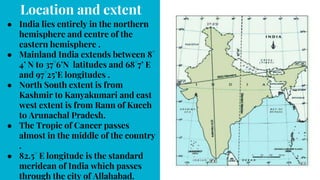
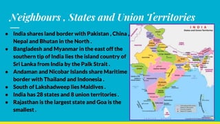
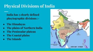
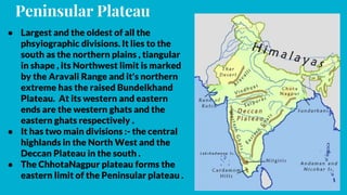
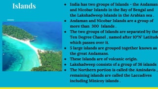
India:- Geographical
Features
● India - its location and extent , its neighbouring
countries .
● Political Divisions of India - states and Union
Territories.
● Phsyiographic divisions of India
Location and extent
● India lies entirely in the northern
hemisphere and centre of the
eastern hemisphere .
● Mainland India extends between 8°
4’ N to 37°6’N latitudes and 68°7’ E
and 97°25’E longitudes .
● North South extent is from
Kashmir to Kanyakumari and east
west extent is from Rann of Kucch
to Arunachal Pradesh.
● The Tropic of Cancer passes
almost in the middle of the country
.
● 82.5° E longitude is the standard
meridean of India which passes
through the city of Allahabad.
Neighbours , States and Union Territories
● India shares land border with Pakistan , China ,
Nepal and Bhutan in the North .
● Bangladesh and Myanmar in the east off the
southern tip of India lies the island country of
Sri Lanka from India by the Palk Strait .
● Andaman and Nicobar Islands share Maritime
border with Thailand and Indonesia .
● South of Lakshadweep lies Maldives .
● India has 28 states and 8 union territories .
● Rajasthan is the largest state and Goa is the
smallest .
Physical Divisions of India
India has 5 clearly defined
phsyiographic divisions :-
● The Himalayas
● The plains of Northern India
● The Peninsular plateau
● The Coastal plains
● The Islands
The Himalayas
● The Himalayas are young fold mountains consisting of 3 parallel ranges - The
Himadri , The Himachal and The Shiwalik range .
● The Himadri is known as such because it remains covered with snow throughout
the year, also called the Great Himalayas or Inner Himalayas
● It is one of the worlds highest mountain ranges , including Mt. Everest (8848m) .
● It has some passes which includes Karakoram pass in Kashmir and Nathula in
Sikkim .
● It has a number of glacier such as the Gangotri and Yamunotri in Uttarakhand .
● The Himachal is also known as the middle of lesser Himalayas . Runs parallel to the
Himadri .
● Doons lie between the Himachal and Shiwalik ranges
● The Shiwalik range is also called the Outer Himalayas .
● It is not a continuous range and known by different names in different places.
Plains of Northern India
● It comprises a vast stretch of level and fertile land formed
by the Alluviam deposited by the rivers like the Indus , the
Ganga and the Brahmaputra together with their
tributaries .
● Indus river has 5 tributaries namely Jhelum, Chenab , Ravi
, Sutlej and Beas .
● The Ganga rises in the Gangothri Glacier in the Himalayas
and it enters the plains of Haridwar in Uttarakhand.
● The main tributaries of Ganga are Yumana , Son, Gaghra,
Gomati , Gandak , Kosi etc.
● The Brahmaputra river rises in Tibet near Lake
Mansoravor and flows eastward as Tsangpo . In Assam the
river is joined by numerous streams namely , Dibang ,
Dibang , Lohit.
● The plains of Northern India can be sub divided based on
regional characteristics:- the Punjab Plain, the Rajasthan
Plain , the Ganga Plains and the Brahmaputra Plains .
● The Punjab Plains lie in Punjab, Haryana and Himachal Pradesh a
significant feature of this plain is the doabs of the 5 tributaries of the Indus
river and thus Punjab derives its names from these rivers , also known as
the land of 5 rivers.
● The Rajasthan plains include Marusthali or the Great Indian Desert . It is a
Sandy Desert and is surrounded by the Sutlej in the Northwest , the Aravali
Range in the East , the Indus valley in the west and Rann Of Kutch . The only
significant river is Luni , which forms an Inland drainage basin . This plains
are dotted with a number of Salt Lakes on the eastern edge of the desert -
Sambhar lake .
● The Ganga Plains consists of a number of regions - Ganga , Yamuna , Doab ,
Awadh , Plains and Mithila Plains . These Plains have been formed by the
sediments brought down by the rivers Ganga , Yamuna , Ghagara and their
tributaries and thus makes one of the most fertile plains in the world .
● The Brahmaputra Plains are low level Plains that extend in Assam for about
640 km , formed by Deposits from the Brahmaputra river and it's
tributaries .
Peninsular Plateau
● Largest and the oldest of all the
phsyiographic divisions. It lies to the
south as the northern plains , tiangular
in shape , its Northwest limit is marked
by the Aravali Range and it's northern
extreme has the raised Bundelkhand
Plateau. At its western and eastern
ends are the western ghats and the
eastern ghats respectively .
● It has two main divisions :- the central
highlands in the North West and the
Deccan Plateau in the south .
● The ChhotaNagpur plateau forms the
eastern limit of the Peninsular plateau .
Central Highlands
● Part of the Peninsular plateau
lying to the North of the
Narmada covering a major area
of the Malwa plateau .
● They are wider in the west but
narrower in the East .
● Eastward extension of this
plateau are known as the
Bundelkhand and Baghelkhand .
● The Malwa plateau is formed by
the lava flows .
● The plateau is broken by rivines ,
mainly in the Chambal, Yamuna ,
Banas valleys.
Deccan Plateau
● It is India's largest plateau and a
triangular landmass that lies to
the south of the river Narmada .
● It occupies the land between the
western and eastern ghats and
south of the Maha Dio , Mykal ,
Vyndia , Satpura ranges
● The River Narmada flows
through a narrow rift valley
between the Vindayas and the
Satpuras
● Another important river of this
region is the Tapti .
● Both these rivers drain into the
Arabian sea .
Western Ghats
● Rise steeply from the West coast
, originate from the river Tapti
to Kanyakumari .
● Higher with Average height of
900-1100 mand the highest
peak is Anaimudi .
● Continuous hills with an
average width of 50-80 km .
● Source of all the important river
of the Deccan Plateau .
● Perpendicular to the south west
monsoon winds and cause
heavy rainfall on their
windward side .
Eastern Ghats
● Rise gently from the east coast ,
originate from Odisha to the Nilgiri
hills .
● Hills are lower with Average height
of about 600metres and th highest
peak is Mahendra Giri .
● Discountinous hills and the width
varies from 100-200 km .
● No river rises here .
● Parallel to the Bay of Bengal branch
of the south west monsoon winds and
do not cause rainfall during monsoon
season . However if causes winter
rainfall on their windward side.
Western coastal plain
● Product of submergence of
land
● Located between the Arabian
sea and the Western Ghats .
● Drained by several short and
swift streams
● They are Indented with many
natural ports
● Narrow with an average width
of 64km
● Do not exhibit many
depositional features
● Fishing is the main occupation
of the people
Eastern coastal plain
● Product of emergence due
deposits.
● Located between the Bay of
Bengal and the Eastern Ghats
● Drained by a number of large
rivers which form Deltas .
● They have a leanier coastline .
● Broader with an average width
of 80-100km
● Many depositional features are
found near the course .
● Farming is the main occupation
of the people .
Islands ● India has two groups of Islands - the Andaman
and Nicobar Islands in the Bay of Bengal and
the Lakshadweep Islands in the Arabian sea .
● Andaman and Nicobar Islands are a group of
more than 300 Islands .
● The two groups of Islands are separated by the
Ten Degree Chanel , named after 10°N’ Latitude
which passes over it.
● 5 large islands are grouped together known as
the great Andamans.
● These Islands are of volcanic origin.
● Lakshadweep consists of a group of 36 islands
● The Northern portion is called the Amindavis ,
remaining islands are called the Laccadives
including Minicoy islands .

India and its Geographical features

  • 1.
    India:- Geographical Features ● India- its location and extent , its neighbouring countries . ● Political Divisions of India - states and Union Territories. ● Phsyiographic divisions of India
  • 2.
    Location and extent ●India lies entirely in the northern hemisphere and centre of the eastern hemisphere . ● Mainland India extends between 8° 4’ N to 37°6’N latitudes and 68°7’ E and 97°25’E longitudes . ● North South extent is from Kashmir to Kanyakumari and east west extent is from Rann of Kucch to Arunachal Pradesh. ● The Tropic of Cancer passes almost in the middle of the country . ● 82.5° E longitude is the standard meridean of India which passes through the city of Allahabad.
  • 3.
    Neighbours , Statesand Union Territories ● India shares land border with Pakistan , China , Nepal and Bhutan in the North . ● Bangladesh and Myanmar in the east off the southern tip of India lies the island country of Sri Lanka from India by the Palk Strait . ● Andaman and Nicobar Islands share Maritime border with Thailand and Indonesia . ● South of Lakshadweep lies Maldives . ● India has 28 states and 8 union territories . ● Rajasthan is the largest state and Goa is the smallest .
  • 4.
    Physical Divisions ofIndia India has 5 clearly defined phsyiographic divisions :- ● The Himalayas ● The plains of Northern India ● The Peninsular plateau ● The Coastal plains ● The Islands
  • 5.
    The Himalayas ● TheHimalayas are young fold mountains consisting of 3 parallel ranges - The Himadri , The Himachal and The Shiwalik range . ● The Himadri is known as such because it remains covered with snow throughout the year, also called the Great Himalayas or Inner Himalayas ● It is one of the worlds highest mountain ranges , including Mt. Everest (8848m) . ● It has some passes which includes Karakoram pass in Kashmir and Nathula in Sikkim . ● It has a number of glacier such as the Gangotri and Yamunotri in Uttarakhand . ● The Himachal is also known as the middle of lesser Himalayas . Runs parallel to the Himadri . ● Doons lie between the Himachal and Shiwalik ranges ● The Shiwalik range is also called the Outer Himalayas . ● It is not a continuous range and known by different names in different places.
  • 6.
    Plains of NorthernIndia ● It comprises a vast stretch of level and fertile land formed by the Alluviam deposited by the rivers like the Indus , the Ganga and the Brahmaputra together with their tributaries . ● Indus river has 5 tributaries namely Jhelum, Chenab , Ravi , Sutlej and Beas . ● The Ganga rises in the Gangothri Glacier in the Himalayas and it enters the plains of Haridwar in Uttarakhand. ● The main tributaries of Ganga are Yumana , Son, Gaghra, Gomati , Gandak , Kosi etc. ● The Brahmaputra river rises in Tibet near Lake Mansoravor and flows eastward as Tsangpo . In Assam the river is joined by numerous streams namely , Dibang , Dibang , Lohit. ● The plains of Northern India can be sub divided based on regional characteristics:- the Punjab Plain, the Rajasthan Plain , the Ganga Plains and the Brahmaputra Plains .
  • 7.
    ● The PunjabPlains lie in Punjab, Haryana and Himachal Pradesh a significant feature of this plain is the doabs of the 5 tributaries of the Indus river and thus Punjab derives its names from these rivers , also known as the land of 5 rivers. ● The Rajasthan plains include Marusthali or the Great Indian Desert . It is a Sandy Desert and is surrounded by the Sutlej in the Northwest , the Aravali Range in the East , the Indus valley in the west and Rann Of Kutch . The only significant river is Luni , which forms an Inland drainage basin . This plains are dotted with a number of Salt Lakes on the eastern edge of the desert - Sambhar lake . ● The Ganga Plains consists of a number of regions - Ganga , Yamuna , Doab , Awadh , Plains and Mithila Plains . These Plains have been formed by the sediments brought down by the rivers Ganga , Yamuna , Ghagara and their tributaries and thus makes one of the most fertile plains in the world . ● The Brahmaputra Plains are low level Plains that extend in Assam for about 640 km , formed by Deposits from the Brahmaputra river and it's tributaries .
  • 8.
    Peninsular Plateau ● Largestand the oldest of all the phsyiographic divisions. It lies to the south as the northern plains , tiangular in shape , its Northwest limit is marked by the Aravali Range and it's northern extreme has the raised Bundelkhand Plateau. At its western and eastern ends are the western ghats and the eastern ghats respectively . ● It has two main divisions :- the central highlands in the North West and the Deccan Plateau in the south . ● The ChhotaNagpur plateau forms the eastern limit of the Peninsular plateau .
  • 9.
    Central Highlands ● Partof the Peninsular plateau lying to the North of the Narmada covering a major area of the Malwa plateau . ● They are wider in the west but narrower in the East . ● Eastward extension of this plateau are known as the Bundelkhand and Baghelkhand . ● The Malwa plateau is formed by the lava flows . ● The plateau is broken by rivines , mainly in the Chambal, Yamuna , Banas valleys. Deccan Plateau ● It is India's largest plateau and a triangular landmass that lies to the south of the river Narmada . ● It occupies the land between the western and eastern ghats and south of the Maha Dio , Mykal , Vyndia , Satpura ranges ● The River Narmada flows through a narrow rift valley between the Vindayas and the Satpuras ● Another important river of this region is the Tapti . ● Both these rivers drain into the Arabian sea .
  • 10.
    Western Ghats ● Risesteeply from the West coast , originate from the river Tapti to Kanyakumari . ● Higher with Average height of 900-1100 mand the highest peak is Anaimudi . ● Continuous hills with an average width of 50-80 km . ● Source of all the important river of the Deccan Plateau . ● Perpendicular to the south west monsoon winds and cause heavy rainfall on their windward side . Eastern Ghats ● Rise gently from the east coast , originate from Odisha to the Nilgiri hills . ● Hills are lower with Average height of about 600metres and th highest peak is Mahendra Giri . ● Discountinous hills and the width varies from 100-200 km . ● No river rises here . ● Parallel to the Bay of Bengal branch of the south west monsoon winds and do not cause rainfall during monsoon season . However if causes winter rainfall on their windward side.
  • 11.
    Western coastal plain ●Product of submergence of land ● Located between the Arabian sea and the Western Ghats . ● Drained by several short and swift streams ● They are Indented with many natural ports ● Narrow with an average width of 64km ● Do not exhibit many depositional features ● Fishing is the main occupation of the people Eastern coastal plain ● Product of emergence due deposits. ● Located between the Bay of Bengal and the Eastern Ghats ● Drained by a number of large rivers which form Deltas . ● They have a leanier coastline . ● Broader with an average width of 80-100km ● Many depositional features are found near the course . ● Farming is the main occupation of the people .
  • 12.
    Islands ● Indiahas two groups of Islands - the Andaman and Nicobar Islands in the Bay of Bengal and the Lakshadweep Islands in the Arabian sea . ● Andaman and Nicobar Islands are a group of more than 300 Islands . ● The two groups of Islands are separated by the Ten Degree Chanel , named after 10°N’ Latitude which passes over it. ● 5 large islands are grouped together known as the great Andamans. ● These Islands are of volcanic origin. ● Lakshadweep consists of a group of 36 islands ● The Northern portion is called the Amindavis , remaining islands are called the Laccadives including Minicoy islands .