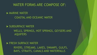
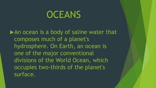
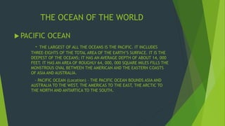
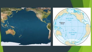
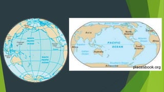
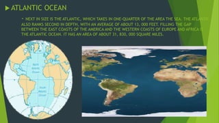
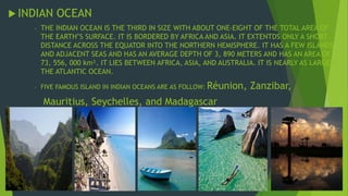
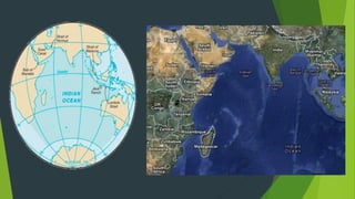
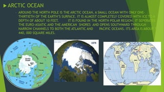
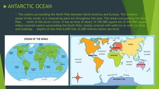
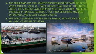
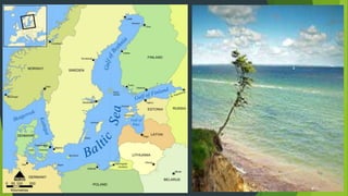
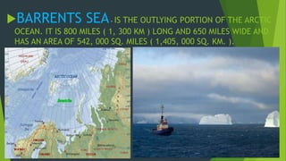
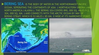
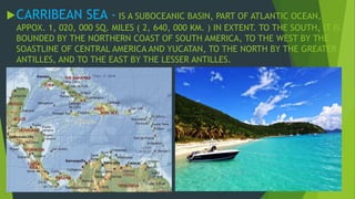
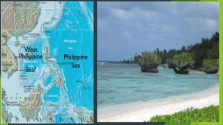
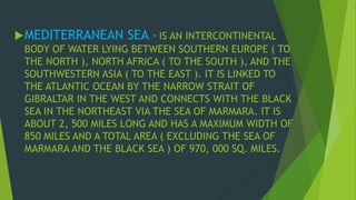
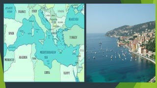
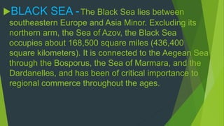
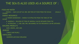
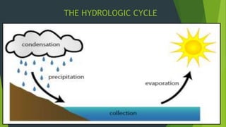
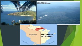
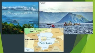
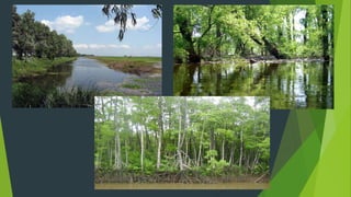
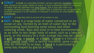
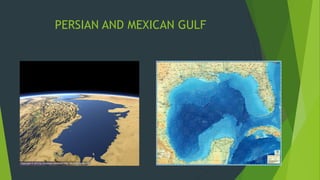
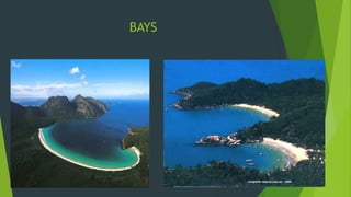
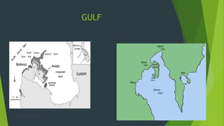
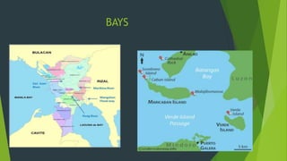
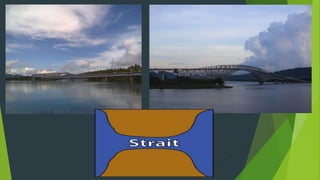
SlideShare a Scribd company logo
1 of 91
THE WATER FORMS 
BY 
JOVILYN MANALIGOD 
CHRISTIAN RABAGO 
BACHELOR OF ELEMENTARY EDUCATION
WATER FORMS ARE COMPOSE OF: 
 MARINE WATER 
COASTAL AND OCEANIC WATER 
 SUBSURFACE WATER 
WELLS, SPRINGS, HOT SPRINGS, GEYSERS AND 
AQUIFERS 
 FRESH SURFACE WATER 
RIVERS, STREAMS, LAKES, SWAMPS, GULFS, 
BAYS, STRAITS, CANALS AND WATERFALLS
TERMINOLOGY: 
HYDROLOGY – IS THE STUDY OF THE WATER OF 
THE EARTH IN THEIR SEVERAL STATES ( SOLID, 
LIQUID AND VAPOR ) AND THE DIVERSE PATHS THAT 
LNK TOGETHER THE OCEANS, ATMOSPHERIC 
MOISTURE AND SURFACE AND GROUNDWATER IN THE 
CONTINENT. 
THE HYDROSPHERE – THE TOTAL VOLUME OF 
WATER AT OR NEAR THE EARTH’S SURFACE IS 
APPROXIMATELY 1, 500, 000, 000 CUBIC KILOMETERS 
( 350, 000, 000 CUBIC MILES ) OF WHICH ALMOST 
99% IS CONTAINED IN THE DISCONTINOUS OCEANIC 
WATER LAYER.
OCEANOLOGY - THE STUDY OF THE 
OCEANS AND SEAS. 
POTAMOLOGY - THE STUDY OF 
RIVERS. 
LIMNOLOGY - THE STUDY OF INLAND 
WATERS SUCH AS LAKES AND PONDS, 
RIVERS, STREAMS, SPRINGS, AND 
WETLANDS.
MARINE WATER 
( COASTAL AND OCEANIC )
OCEANS 
An ocean is a body of saline water that 
composes much of a planet's 
hydrosphere. On Earth, an ocean is 
one of the major conventional 
divisions of the World Ocean, which 
occupies two-thirds of the planet's 
surface.
SAMPLE IMAGE:
THE OCEAN OF THE WORLD 
 PACIFIC OCEAN 
- THE LARGEST OF ALL THE OCEANS IS THE PACIFIC. IT INCLUDES 
THREE-EIGHTS OF THE TOTAL AREA OF THE EARTH’S SURFACE. IT IS THE 
DEEPEST OF THE OCEANS; IT HAS AN AVERAGE DEPTH OF ABOUT 14, 000 
FEET. IT HAS AN AREA OF ROUGHLY 64, 000, 000 SQUARE MILES FILLS THE 
MONSTROUS OVAL BETWEEN THE AMERICAN AND THE EASTERN COASTS 
OF ASIA AND AUSTRALIA. 
- PACIFIC OCEAN (Location) – THE PACIFIC OCEAN BOUNDS ASIA AND 
AUSTRALIA TO THE WEST, THE AMERICAS TO THE EAST, THE ARCTIC TO 
THE NORTH AND ANTARTICA TO THE SOUTH.
ATLANTIC OCEAN 
- NEXT IN SIZE IS THE ATLANTIC, WHICH TAKES IN ONE-QUARTER OF THE AREA THE SEA. THE ATLANTIC 
ALSO RANKS SECOND IN DEPTH, WITH AN AVERAGE OF ABOUT 13, 000 FEET. FILLING THE GAP 
BETWEEN THE EAST COASTS OF THE AMERICA AND THE WESTERN COASTS OF EUROPE AND AFRICA IS 
THE ATLANTIC OCEAN. IT HAS AN AREA OF ABOUT 31, 830, 000 SQUARE MILES.
 INDIAN OCEAN 
- THE INDIAN OCEAN IS THE THIRD IN SIZE WITH ABOUT ONE-EIGHT OF THE TOTAL AREA OF 
THE EARTH’S SURFACE. IT IS BORDERED BY AFRICA AND ASIA. IT EXTENTDS ONLY A SHORT 
DISTANCE ACROSS THE EQUATOR INTO THE NORTHERN HEMISPHERE. IT HAS A FEW ISLANDS 
AND ADJACENT SEAS AND HAS AN AVERAGE DEPTH OF 3, 890 METERS AND HAS AN AREA OF 
73, 556, 000 km². IT LIES BETWEEN AFRICA, ASIA, AND AUSTRALIA. IT IS NEARLY AS LARGE AS 
THE ATLANTIC OCEAN. 
- FIVE FAMOUS ISLAND IN INDIAN OCEANS ARE AS FOLLOW: Réunion, Zanzibar, 
Mauritius, Seychelles, and Madagascar
ARCTIC OCEAN 
- AROUND THE NORTH POLE IS THE ARCTIC OCEAN, A SMALL OCEAN WITH ONLY ONE-THIRTIETH 
OF THE EARTH’S SURFACE. IT IS ALMOST COMPLETELY COVERED WITH ICE TO A 
DEPTH OF ABOUT 10 FEET. IT IS FOUND IN THE NORTH POLAR REGION. IT SEPERATES 
THE EURO-ASIATIC AND THE AMERICAN SHORES AND OPENS SOUTHWARD THROUGH 
NARROW CHANNELS TO BOTH THE ATLANTIC AND PACIFIC OCEANS. ITS AREA IS ABOUT 5, 
440, 000 SQUARE MILES.
ANTARCTIC OCEAN 
- The waters surrounding the North Pole between North America and Eurasia. The smallest 
ocean in the world, it is covered by pack ice throughout the year. The ocean surrounding the North 
Pole, north of the Arctic Circle. It has an Area of about 14 100 000 square km (5 440 000 square 
miles) covered waters surrounding the North Pole; mostly covered with solid ice or with ice floes 
and icebergs. depths of less than 6,650 feet (2,000 metres) below sea level.
 THE PHILIPPINES HAS THE LONGEST DISCONTINUOOUS COASTLINE IN THE 
WORLD WITH 34, 600 K. M., TWICE LONGER THAN THAT OF THE UNITED 
STATES. THE SEACOASTS ARE INDENTED WITH BAYS, HARBORS, AND GULFS. 
THERE ARE 61 NATURAL HARBORS, 31 OF THEM DEVELOPED AND USED 
EXTENSIVELY, AND 20 LAND-LOCKED STRAITS. 
 THE FINEST HARBOR IN THE FAR EAST IS MANILA, WITH AN AREA OF 1, 970 
KM. AND A COASTLINE OF 192 KM.
THE SEAS 
 THE PHILIPPINES HAS THE LONGEST DISCONTINUOOUS COASTLINE IN THE WORLD WITH 34, 600 
K. M., TWICE LONGER THAN THAT OF THE UNITED STATES. THE SEACOASTS ARE INDENTED WITH 
BAYS, HARBORS, AND GULFS. THERE ARE 61 NATURAL HARBORS, 31 OF THEM DEVELOPED AND 
USED EXTENSIVELY, AND 20 LAND-LOCKED STRAITS. 
 THE FINEST HARBOR IN THE FAR EAST IS MANILA, WITH AN AREA OF 1, 970 KM. AND A COASTLINE 
OF 192 KM.
THE WORLD'S SEAS INCLUDE: 
ANDAMAN SEA - IS THE NORTHEASTERN ARM 
OF INDIAN OCEAN, WITH AN AREA OF 308, 000 
SQ. MILES (978, 000 SQ. KM. ). IT IS BOUNDED BY 
THE IRRAWADY DELTA ( NORTH ), BY PENINSULAR 
BURMA, THAILAND, AND MALAYSIA ( EAST ), BY 
THE ANDAMAN AND AND NICOBAR ISLANDS ( WEST 
), AND BY SUMATRA ( INDONESIA ), AND STRAIT 
OF MALACCA ( SOUTH ). THE SEA IS 750 MILES ( 
1, 200 KM. ) LONG FROM NORTH TO SOUTH AND 
400 MILES WIDE.
BALTIC SEA - IS THE WORLD'S LARGEST 
BODY OF BRACKISH WATER. IT HAS AN AREA OF 
1, 600 SQ. MILES ( 42, 000 SQ. KM. ). IT CURVES 
NORTHWARD FROM THE LATITUDE OF DENMARK 
ALMOST TO THE ARCTIC CIRCLE, SEPERATING 
THE SCANDINAVIAN PENINSULA FROM THE MAIN 
BODY OF THE EUROPIAN LANDMASS.
BARRENTS SEA- IS THE OUTLYING PORTION OF THE ARCTIC 
OCEAN. IT IS 800 MILES ( 1, 300 KM ) LONG AND 650 MILES WIDE AND 
HAS AN AREA OF 542, 000 SQ. MILES ( 1,405, 000 SQ. KM. ).
BERING SEA - IS THE BODY OF WATER IN THE NORTHERNMOST PACIFIC 
OCEAN, SEPERATING THE CONTINENTS OF ASIA ( NORTHEASTERN SIBERIA ) AND 
NORTH AMERICA ( ALASKA ). THE BERING SEA COVERS 890, 000 SQ. MILES 9 2, 
304, 000 SQ. KM. ) AND CONNECTS WITH THE ARCTIC OCEAN BY WAY OF 
BERING STRAIT, WHICH IS 53 MILES ( 85 KM. 0 WIDE AT ITS NARROWEST POINT.
CARRIBEAN SEA - IS A SUBOCEANIC BASIN, PART OF ATLANTIC OCEAN, 
APPOX. 1, 020, 000 SQ. MILES ( 2, 640, 000 KM. ) IN EXTENT. TO THE SOUTH, IT IS 
BOUNDED BY THE NORTHERN COAST OF SOUTH AMERICA, TO THE WEST BY THE 
SOASTLINE OF CENTRAL AMERICA AND YUCATAN, TO THE NORTH BY THE GREATER 
ANTILLES, AND TO THE EAST BY THE LESSER ANTILLES.
CHINA SEA - IS THE PART OF THE WESTERN PACIFIC OCEAN BORDERING ON 
THE SOUTH ASIAN MAINLAND. IT COVERS AN AREA OF ABOUT 1, 340, 000 SQ. 
MILES ( 3, 465, 000 SQ.KM. ) AND CONSIST OF THE SOUTH CHINA SEA AND EAST 
CHINA SEA, WHICH CONNECT TO THE FORMOSA STRAIT BETWEEN TAIWAN AND 
CHINA MAINLAND.
RED SEA - CONTAINS THE WORLD'S HOTTEST AND SALTIEST SEA WATER. A 
NARROW STRIP OF WATER EXTENDING SOUTHEASTWARD FOR 1, 300 MILES ( 2, 
100 KM. 0, FROM SUEZ TO THE BAB (STRAIT) EL- MANDEB AND THE GULF OF 
ODEN. IT SEPERATES NORTHEAST AFRICA FROM THE ARABIAN PENINSULA. IT HAS 
AN AREA OF 169, 000 SQ. MILES ( 438, 000 ) SQ. KM. ) WITH DISTANCES VARYING 
FROM 130 TO 250 MILES ( 210-400 KM. ).
SEA OF JAPAN - IS THE MARGINAL SEA OF THE PACIFIC OCEAN WHICH 
LIES BETWEEN JAPAN AND THE SOVIET ISLAND OF SAKHALIN (EAST) AND 
THE ASIAN MAINLAND OF THE SOVIET UNION AND KOREA (WEST). IT HAS 
SURFACE AREA OF 389, 100 SQ. MILES ( 1, 007, 800 SQ. KM. ) AND A MEAN 
DEPTH OF 4, 429 FT. ( 1, 350 M. ).
PHILIPPINE SEA -The Philippine Sea is bordered by the Philippines and 
Taiwan to the west, Japan to the north, the Marianas to the east and Palau to the 
south. Adjacent seas include Celebes Seawhich is separated by Mindanao and 
smaller islands to the south, South China Sea which is separated by Philippines, 
and East China Sea which is separated by the Ryukyu Islands. 
 They surround an area measuring 1,800 miles (2,900 km) north-south by 
1,500 miles east-west and occupying a total surface area of 40,000 square 
miles (1,000,000 square km), about 3 percent of the entire Pacific region. 
The basin, with a general depth of 19,700 feet (6,000 m), plunges to its 
greatest depths in trenches to the east of the island arcs. The deepest is 
the Philippine Trench at 34,578 feet (10,539 m).
MEDITERRANEAN SEA - IS AN INTERCONTINENTAL 
BODY OF WATER LYING BETWEEN SOUTHERN EUROPE ( TO 
THE NORTH ), NORTH AFRICA ( TO THE SOUTH ), AND THE 
SOUTHWESTERN ASIA ( TO THE EAST ). IT IS LINKED TO 
THE ATLANTIC OCEAN BY THE NARROW STRAIT OF 
GIBRALTAR IN THE WEST AND CONNECTS WITH THE BLACK 
SEA IN THE NORTHEAST VIA THE SEA OF MARMARA. IT IS 
ABOUT 2, 500 MILES LONG AND HAS A MAXIMUM WIDTH OF 
850 MILES AND A TOTAL AREA ( EXCLUDING THE SEA OF 
MARMARA AND THE BLACK SEA ) OF 970, 000 SQ. MILES.
BLACK SEA - The Black Sea lies between 
southeastern Europe and Asia Minor. Excluding its 
northern arm, the Sea of Azov, the Black Sea 
occupies about 168,500 square miles (436,400 
square kilometers). It is connected to the Aegean Sea 
through the Bosporus, the Sea of Marmara, and the 
Dardanelles, and has been of critical importance to 
regional commerce throughout the ages.
SEA WATER COMPOSITION 
 GEOLOGISTS BELIEVE THAT THE EARTH IN ITS EARLY STAGES WAS WITHOUT 
OCEANS. ALL THE EARTH'S WATER WAS PROBABLY CHEMICALLY BOUND WITHIN 
THE ROCKS UNTIL VOLCANISM RELEASED IT. SOME OF TH VOLCANIC ACTIONS 
ORIGINALLY PRODUCE THE OCEANS ARE STILL GOING ON. THUS, IT IS 
REASONABLE TO SUPPOSE THAT THE OCEANS ARE STILL GROWING TODAY. 
 THE COMPOSITION OF SEA WATER TODAY IS NOT THE SAME AS THAT OF THE 
WATER THAT FILLED THE ORIGINAL OCEANS. WHEN THE WATER WAS FIRST 
RELEASED FROM THE ORIGINAL ROCKS, IT WAS NOT SALTY. IT ONLY BECAME 
SALTY AFTER RAIN HAD WASH OVER THE LAND ON ITS WAY TO THE OCEANS 
BASINS. AS THE LAND WAS FLOODED BY THE DOWNFALL OF RAIN, MINERALS 
WERE DISSOLVED AND CARRIED INTO THE SEA. SINCE THE OCEANS WERE 
FORMED, THE SAME PROCESSED HAVE BEEN GOING ON AGAIN AND AGAIN IN AN 
ENDLESS HYDROLOGIC CYCLE. 
 THE MOST ABUNDANT AND SOLUBLE IN WATER AND COMMON MINERAL IS THE 
TABLE SALT ( SODIUM CHLORIDE ) LEADS THE FIRST.
MINERALS FROM THE SEA 
 THE DISSOLVED MINERALS IN THE SEA WATER ARE USEFUL AND 
VALUEABLE. 
 EACH CUBIC MILE OF SEA WATER CONTAINS ABOUT 4 MILLION TONS OF 
MAGNESIUM. THESE LIGHT METALS ARE USED IN AIRCRAFT AND MANY 
OTHER APPLICATIONS. 
 ALMOST ALL OF THE WORLD'S SUPPLY OF MAGNESIUM IS EXTRACTED 
FROM SEA WATER. THE ELEMENT BROMINE ( USED IN HIGH TEST 
GASOLINE AND PHOTOGRAPHIC FILM ) AND MANY CHEMICALS ARE 
OBTAINED FROM SEA WATER. 
 NATURALLY, THE SEA IS AN IMPORTANT SOURCE OF ORDINARY SALT. THIS 
IS AN ESSENTIAL MATERIAL FOR SEVERAL CHEMICAL INDUSTRIES. ***
ECONOMIC ASPECTS OF OCEANS AND SEAS 
 THE SEA IS GENERALLY ACCEPTED BY SCIENTISTS AS THE PLACE 
WHERE LIFE BEGAN ON EARTH. WITHOUT THE SEA, LIFE AS IT IS 
KNOWN TODAY WOULD NOT EXIST. IT ACTS AS A GREAT HEAT 
RESERVOIR, LEVELLING THE TEMPERATURE EXTREMES THAT 
WOULD OTHERWISE PREVAIL OVER THE EARTH AND EXPAND THE 
DESERT AREAS. 
 THE OCEANS PROVIDE THE LEAST EXPENSIVE FORM OF 
TRANSPORTATION KNOWN TO MAN, AND THE MARGINS OF THE 
SEA SERVE AS ONE OF THE MAJOR SITES OF RECREATION. 
 THE SEA IS A MAJOR SOURCE OF FOOD AND A DUMPING GROUND 
FOR MANY WASTES. THE SEA IS ALSO A MAJOR POTENTIAL 
SOURCE OF PROTEIN, MINERALS, AND POWER, ALL OF WHICH 
ARE REQUIRED IN EVER-INCREASING QUANTITIES BY ALL 
INDUSTRIAL SOCIETIES.
THE SEA IS ALSO USED AS A SOURCE OF : 
FOOD AND WATER 
FISHING --- MAN CAN GET 60, 000, 000 TONS OF FOOD FROM THE OCEAN ANUALLY BY 
FISHING. 
ENERGY RESOURCES 
A. POWER GENERATION--- ENERGY IS EXTRACTED FROM THE TIDES OF THE 
OCEAN. 
B. MINERALS--- BILLIONS OF TONS OF MINERAL CAN BE OBTAINED FROM THE SEA. 
C. PETROLEUM--- 2, 000, 000, 000, 000 BARRELS OF OIL RESOURCES CAN BE OBTAINED. 
BUILDING PRODUCTS 
SAND, GRAVEL, AND LIME. 
JEWELRY 
CORALS AND PEARLS 
FERTILIZERS 
SEAWEEDS AND DEAD ORGANISM
SUBSURFACE WATER 
( WELLS, SPRINGS, HOT SPRINGS, 
GEYSERS, AND AQUIFERS )
THE HYDROLOGIC CYCLE
GROUND WATER - IS FOUND AT MOST A FEW 
KILOMETERS FROM THE CRUST. 
SUBSURFACE WATER - THESE ARE WATER 
THAT OCCUPY PORES SPACES BELOW THE GROUND 
SURFACE.
 WELLS - IS A HOLE THAT IS DUG OR DRILLED DEEP ENOUGH INTO THE 
GROUND TO REACH THE WATER TABLE. IT IS FORMED WHEN WATER FLOWS 
INTO AND FILLS UP THE HOLE. WELLS IN PERMEABLE SEDIMENTARY ROCKS 
WHERE THE GRADIENT OF WATER IS GOOD WILL USUALLY PROVIDE AN 
ABUNDANT SUPPLY OF WATER. THE WATER WITHDRAWN IS QUICKLY 
REPLENISHED BY THE RAPIDLY MOVING GROUND WATER. HOWEVER, IF THE 
WELL IS TOO SHALLOW, THE WATER TABLE MAY DROP BELOW THE WELL IN 
DRY PERIODS. 
 ARTESIAN WELL - IS THE TYPE OF WELL WHEREIN THE WATER IS 
OBTAINED FROM AN AQUIFER IN A POROUS ROCK LAYER USUALLY 
CONSISTING OF SANDSTONE OR LOOSE SAND AND GRAVEL. 
- IT IS USUALLY DRILLED SEVERAL THOUSAND FEET DEEP IN 
ORDER TO REACHED THE AQUIFER. HOWEVER, ORDINARY WELLS ARE 
FREQUENTLY SUNK THIS DEEP IN ORDER TO MAINTAIN CONSTANT 
CONTACT WITH THE WATER TABLE.****
AQUIFERS - An aquifer is an underground layer of water-bearing rock. Water-bearing 
rocks are permeable, meaning that they have openings that liquids and 
gases can pass through.Sedimentary rock such as sandstone, as well as sand and 
gravel, are examples of water-bearing rock. The top of the water level in an aquifer is 
called the water table. 
- An aquifer fills with water from rain or melted snow that drains into the 
ground. 
- Aquifers act as reservoirs for groundwater. Wells drilled into aquifers provide 
water for drinking, agriculture, and industrialuses. 
- There are two types of aquifers. An unconfined aquifer is covered by 
permeable rock and can receive water from the surface. The water table of 
an unconfined aquifer rises or falls depending on the amount of water 
entering and leaving the aquifer. It is only partly filled with water. 
In contrast, a confined aquifer lies between two layers of less permeable 
rocks and is filled with water. Water trickles down through cracks in the upper 
layer of less permeable rock, a nearby water source, such as an underground 
river or lake, or a nearby unconfined aquifer.
SPRINGS-OCCURS WHENEVER GROUND WATER 
COMES NATURALLY TO THE SURFACE. SOME 
SPRINGS ARE DISCHARGED WHERE THE WATER 
TABLE INTERSECTS THE LAND SURFACE BUT THEY 
MAY OCCUR WHERE WATER FLOWS OUT FROM A 
CAVERN OR ALONG FRACTURES, FAULTS, OR ROCK 
CONTACTS THAT COME TO THE SURFACE. 
- MAY OCCUR ON HILLSIDE WHERE THE WATER 
TABLE INTERSECTS THE LAND SURFACE. 
- SPRING WATER CONTAINING DISSOLVED 
MINERALS COMES FROM WHAT ARE CALLED 
MINERAL SPRINGS.***
HOT SPRINGS - ARE FORMED WHEN WATER 
GETS HEATED BY NEARBY MAGMA BEFORE COMING OUT 
OF THE EARTH. 
- WATER MAY ALSO BE HEATED BY MIXING 
WITH STEAM AND HOT GASSES FROM BODIES OF MAGMA 
ESCAPING INTO THE SURFACE. 
- AROUND MOUNT MAKILING IN CALAMBA 
AND LOS BANOS AND MAYON VOLCANO IN ALBAY ARE 
PLENTY OF HOT SPRINGS. 
- THE TEMPERATURE OF THE VARIOUS HOT 
SPRINGS RANGES FROM 6 DEGREE TO 9 DEGREE 
CELCIUS.***
GEYSERS - A HOT SPRING THAT EMITS STEAM AND HOT 
WATER PERIODICALLY IS CALLED GEYSER. THE INTERVAL 
BETWEEN ERUPTIONS INDICATES THE TIMES IT TAKES THE 
GROUND WATER TO GET HEATED. A COLUMN OF STEAM AND 
BOILING WATER MAY BE THROWN UP HIGH. THEN THE GROUND 
WATER COLLECTS AGAIN AND THE PROSSESES ARE REPEATED. 
SOME GEYSERS ARE LOCATED NEAR ACTIVE VOLCANIC AREAS AND 
ERUPT FROM OPEN POOLS; OTHERS ERUPT THROUGH A SMALL 
OPENING AND JETS OF WATER AND STEAM RESULT.
SURFACE WATER 
(LAKES, SWAMPS, RIVERS, STREAMS, STRAITS, GULFS, BAYS, CANALS AND 
WATERFALLS)
LAKES - LAKES ARE COMMON ELEMENTS OF THE ANDSCAPE 
FORMED WHEN A DEPRESSION CALLED A BASIN IS FILLED WITH 
WATER. 
- THEY ALSO SERVE AS RESERVOIRS, PROVIDING WATER 
FOR GENERATING ELECTRICITY AND WATER USED IN INDUSTRY AND 
AGRICULTURE.ALSO PROVIDE CHEAP TRANSPORTATION. 
- FISHING IN THE LAKE IS A SOURCE OF LIVELIHOOD AND 
A FORM OF RECREATION. 
- THERE ARE ABOUT 59 LAKES IN THE COUNTRY. THE SIX 
LARGEST LAKES ARE: LAGUNA DE BAY WITH AN AREA OF 922, 142 
SQ. KM.; LAKE LANAO DEL SUR WITH AN AREA OF 374, 000 SQ. KM; 
LAKE MAINIT IN SURIGAO DEL NORTE WITH AN AREA OF 150, 220 
SQ. KM.; LAKE NAUJAN IN ORIENTAL MINDORO WITH AN AREA OF 
69, 930 SQ. KM.; AND LAKE BULUAN IN SULTAN KUDARAT WITH AN 
AREA OF 59, 570 SQ. KM. 
- TAAL LAKE IN BATANGAS IS KNOWN AS THE SMALLEST 
LAKE IN THE WORLD WITH AN AREA OF 234.2 SQ.KM.***
SWAMPS - BASIN THAT BECOME PARTLY OR 
COMPLETELY FILLED WITH FRESH AND DECAYED 
VEGETATION SEDIMENT IN WATER ARE CALLED 
SWAMPS. THEY USUALLY ARE A STAGE IN THE 
CHANGINGOF A LAKE OR POND INTO DRY LAND. THEY 
BECOME LAKE DURING RAINY SEASONS AND SWAMPS 
DURING DRY MONTHS. ***
RIVERS - A river is a natural watercourse, usually freshwater, 
flowing towards an ocean, a lake, a sea, or another river. In some 
rare cases a river could flow into the ground and dry up completely 
at the end of its course, without reaching another body of water. 
Small rivers may be called by several other names, including 
stream, creek, brook, rivulet, and rill. 
STREAMS - MUCH RAIN IS ABSORB BY PLANTS AND SOIL. BUT 
EXCESS RAIN RUNS OFF INTO LOW-LYING AREAS TO JOIN OR TO FORM 
A STREAM.THEY ARE ALSO KEPT SUPPLIED BY WATER THAT 
GRADUALLY SEEPS TOWARD THEM UNDER THE SURFACE OF THE 
GROUND. A STREAM IS A FLOWING BODY OF WATER OR A SMALL 
RIVER.
AMAZON AND GANGES RIVER
CONGO AND INDUS RIVER
NILE AND YELLOW RIVER
 THERE ARE ABOUT 132 NAVIGABLE RIVERS AND VALUABLE MEANS OF 
TRANSPORTATION IN THE COUNTRY. 
 THE CAGAYAN RIVER A.K.A. RIO GRANDE DE CAGAYAN IS THE LARGEST 
WITH AN AREA OF 505 KM. 
 Economic importance of the C.R. The river drains a fertile valley that 
produces a variety of crops, including rice, corn, bananas, coconut, 
citrus and tobacco. 
 There are dams in two of the river's tributaries, the Magat and Chico 
Rivers, and there are also several mining concessions in the mineral-rich 
Cordillera Mountains near the headwaters of the two tributary rivers. 
 The provincial governments along the river have also developed tourism 
programs that offer activities on the river, particularly whitewater 
rafting. 
 OTHER IMPORTANT RIVERS IN LUZON ARE THE PAMPANGA AND AGNO 
RIVER; AGUSAN AND PULANGI IN MINDANAO. THE PASIG RIVER IS THE 
OUTLET OF LAGUNA DE BAY AND SITUATED AT ITS MOUTH IS THE CITY OF 
MANILA.
PAMPANGA AND AGNO RIVER
CAGAYAN AND PASIG RIVER
CLASSIFICATION OF RIVER ACCRDNG TO THEIR 
AGE 
Youthful river: A river with a steep gradient that has very few tributaries and flows 
quickly. Its channels erode deeper rather than wider. Examples include the Brazos, Trinity and 
Ebro rivers. 
Mature river: A river with a gradient that is less steep than those of youthful rivers and 
flows more slowly. A mature river is fed by many tributaries and has more discharge than a 
youthful river. Its channels erode wider rather than deeper. Examples include theMississippi, 
Saint Lawrence, Danube, Ohio, Thames and Paraná rivers. 
Old river: A river with a low gradient and low erosive energy. Old rivers are characterized by 
flood plains. Examples include the Yellow,Ganges, Tigris, Euphrates, Indus and Nile rivers. 
Rejuvenated river: A river with a gradient that is raised by tectonic uplift.
 STRAIT - A strait is a naturally formed, narrow, typically navigable waterway 
that connects two larger bodies of water. It most commonly refers to a channel 
of water that lies between two land masses, but it may also refer to a 
navigable channel through a body of water that is otherwise not navigable, for 
example because it is too shallow, or because it contains an unnavigable reef or 
archipelago. 
 GULF - a large bay that is an arm of an ocean or sea. 
 BAYS -A bay is a large body of water connected to an 
ocean or sea, formed by an inlet of water due to the 
surrounding land blocking some waves and often 
reducing winds. Bays also exist in in-land environments 
as an inlet to any larger body of water, such as a lake or 
pond, or the estuary of a river, A large bay may be called 
a gulf, a sea, a sound, or a bight. A cove is a circular or 
oval coastal inlet with a narrow entrance; some coves 
may be referred to as bays. A fjord is a particularly 
steep bay shaped by glacial activity.
PERSIAN AND MEXICAN GULF
BAYS
GULF
BAYS
CANALS - Canals and navigations are human-made channels for 
water. In the vernacular both are referred to as 'canals'. The main 
difference between them is that a navigation parallels a river and 
shares its drainage basin, while a canal cuts across a drainage 
divide. 
 TYPES OF CANALS 
There are two broad types of canal: 
Waterways: canals and navigations used for carrying vessels transporting goods and people. These can be 
subdivided into two kinds: 
 Those connecting existing lakes, rivers, other canals or seas and oceans. 
 Those connected in a city network: such as the Canal Grande and others of Venice Italy; the gracht of Amsterdam, 
and the waterways of Bangkok. 
Aqueducts: water supply canals that are used for the conveyance and delivery ofpotable water for human 
consumption, municipal uses, hydro power canals andagriculture irrigation.
 CONSTRUCTION OF CANALS: 
A. HUMAN MADE STREAMS 
B. CANALIZATION AND NAVIGATIONS 
C. LATERAL CANALS
CANALS
WATERWAYS
AQUEDUCTS
WATERFALLS - A WATERFALL IS ANY STREAM OF WATER DESCENDING 
SUDDENLY FROM A HIGHER TO A LOWER LEVEL.IF THE VOLUME OF 
WATER IS SMALL, IT IS CALLED A CASCADE;IF IT IS LARGE, IT IS CALLED A 
CATARACT.
SUBSIDENCE 
 Subsidence is the motion of a surface (usually, the Earth's surface) 
as it shifts downward relative to a datum such as sea-level. 
 Subsidence frequently causes major problems in karst terrains, where 
dissolution of limestone by fluid flow in the subsurface causes the 
creation of voids (i.e. caves). If the roof of these voids becomes too 
weak, it can collapse and the overlying rock and earth will fall into 
the space, causing subsidence at the surface. This type of subsidence 
can result in sinkholes which can be many hundreds of meters deep. 
 Sinkhole is a depression or hole in the ground caused by some form 
of collapse of the surface layer. Some are caused by karst processes
TYPES OF SINKHOLE 
Solution Sinkholes 
Solution sinkholes occur in areas where limestone is exposed at land 
surface or is covered by thin layers of soil and permeable sand. Solution is 
most active at the limestone surface and along joints, fractures or other 
openings in the rock that permit water to move easily into the subsurface. 
Dissolved limestone and some insoluble residue are carried downward by 
percolating water along enlarged openings as solution of the limestone 
progresses. Large voids commonly do not form because subsidence of the 
soil layer occurs as the limestone surface dissolves. The result is a gradual 
downward movement of the land surface and development of a depression 
that collects increasing amounts of surface runoff as its perimeter expands. 
This type of sinkhole usually forms as a bowl-shaped 
The gently rolling hills and shallow depressions typical of solution-subsidence 
topography are common over large parts of Florida.
Cover Collapse Sinkholes 
Cover-collapse sinkholes occur where a solution cavity develops in the 
limestone to a size such that the overlying cover material can no longer 
support its own weight. Collapse is generally abrupt when this occurs 
and is sometimes catastrophic. Collapse sinkholes provide dramatic 
local changes in topography. They may occur in any areas of soluble 
rock; however, they are less likely to occur in areas of deeply buried 
rocks. 
Collapse sinkholes generally occur in areas where the limestone is near 
land surface and the limestone aquifer is under water-table conditions. 
Ground-water circulation is most vigorous at and just below the water-table 
where solution of the limestone is accelerated. Accelerated 
solution also may occur at certain depths where bedding planes in the 
limestone or changes in rock composition concentrate the flow of 
groundwater.
Cover Subsidence Sinkholes 
Cover-subsidence sinkholes occur where the cover material is 
relatively incohesive and permeable, and individual grains of 
sand move downward in sequence to replace grains that have 
themselves moved downward to occupy space formerly held by 
dissolved limestone. In areas where the sand cover is 50 to 100 
feet thick, subsidence sinkholes generally are only are few feet 
in diameter and depth.
THANK YOU 
FOR LISTENING 
:-*
THE WATERFORMS
THE WATERFORMS

More Related Content

What's hot

Mga katangiang pisikal ng pilipinas
Mga katangiang pisikal ng pilipinasMga katangiang pisikal ng pilipinas
Mga katangiang pisikal ng pilipinasFloraine Floresta
 
Mga rehiyon ng pilipinas
Mga rehiyon ng pilipinasMga rehiyon ng pilipinas
Mga rehiyon ng pilipinasCool Kid
 
interactions among living things in estuary
interactions among living things in estuary interactions among living things in estuary
interactions among living things in estuary Gabriel Mavis
 
Bodies of Water in the Philippines by Group 2
Bodies of Water in the Philippines by Group 2Bodies of Water in the Philippines by Group 2
Bodies of Water in the Philippines by Group 2Alexa Dayot
 
Top 10 Tourist Attractions in the Philippines
Top 10 Tourist Attractions in the PhilippinesTop 10 Tourist Attractions in the Philippines
Top 10 Tourist Attractions in the PhilippinesJemilaTadiaAlmirol
 
Ang Hangganan at Lawak ng Teritoryo ng Pilipinas
Ang Hangganan at Lawak ng Teritoryo ng PilipinasAng Hangganan at Lawak ng Teritoryo ng Pilipinas
Ang Hangganan at Lawak ng Teritoryo ng PilipinasMavict De Leon
 
Volcanoes In the Philippines
Volcanoes In the PhilippinesVolcanoes In the Philippines
Volcanoes In the PhilippinesChristine Serrano
 
Geography of the philippines.pptxjjkkk
Geography of the philippines.pptxjjkkkGeography of the philippines.pptxjjkkk
Geography of the philippines.pptxjjkkkJerlie
 
Araling Panlipunan 6- Ang Lokasyon at Teritoryo ng Pilipinas
Araling Panlipunan 6- Ang Lokasyon at Teritoryo ng PilipinasAraling Panlipunan 6- Ang Lokasyon at Teritoryo ng Pilipinas
Araling Panlipunan 6- Ang Lokasyon at Teritoryo ng PilipinasLuvyankaPolistico
 
17 rehiyon iv-a-calabarzon
17   rehiyon iv-a-calabarzon17   rehiyon iv-a-calabarzon
17 rehiyon iv-a-calabarzonjeannette_21
 

What's hot (20)

Mga katangiang pisikal ng pilipinas
Mga katangiang pisikal ng pilipinasMga katangiang pisikal ng pilipinas
Mga katangiang pisikal ng pilipinas
 
Mga anyong tubig
Mga anyong tubigMga anyong tubig
Mga anyong tubig
 
Anyong Lupa at Anyong Tubig
Anyong Lupa at Anyong TubigAnyong Lupa at Anyong Tubig
Anyong Lupa at Anyong Tubig
 
Mga rehiyon ng pilipinas
Mga rehiyon ng pilipinasMga rehiyon ng pilipinas
Mga rehiyon ng pilipinas
 
Mga anyong tubig
Mga anyong tubigMga anyong tubig
Mga anyong tubig
 
interactions among living things in estuary
interactions among living things in estuary interactions among living things in estuary
interactions among living things in estuary
 
Cagayan Valley Region 2
Cagayan Valley Region 2Cagayan Valley Region 2
Cagayan Valley Region 2
 
Mga Katangiang Pisikal ng Pilipinas
Mga Katangiang Pisikal ng PilipinasMga Katangiang Pisikal ng Pilipinas
Mga Katangiang Pisikal ng Pilipinas
 
Weather disturbance
Weather disturbanceWeather disturbance
Weather disturbance
 
Bodies of Water in the Philippines by Group 2
Bodies of Water in the Philippines by Group 2Bodies of Water in the Philippines by Group 2
Bodies of Water in the Philippines by Group 2
 
Top 10 Tourist Attractions in the Philippines
Top 10 Tourist Attractions in the PhilippinesTop 10 Tourist Attractions in the Philippines
Top 10 Tourist Attractions in the Philippines
 
Ang Hangganan at Lawak ng Teritoryo ng Pilipinas
Ang Hangganan at Lawak ng Teritoryo ng PilipinasAng Hangganan at Lawak ng Teritoryo ng Pilipinas
Ang Hangganan at Lawak ng Teritoryo ng Pilipinas
 
Volcanoes In the Philippines
Volcanoes In the PhilippinesVolcanoes In the Philippines
Volcanoes In the Philippines
 
Yamang tubig
Yamang tubigYamang tubig
Yamang tubig
 
Anyong tubig
Anyong tubigAnyong tubig
Anyong tubig
 
Geography of the philippines.pptxjjkkk
Geography of the philippines.pptxjjkkkGeography of the philippines.pptxjjkkk
Geography of the philippines.pptxjjkkk
 
Uri ng pangngalan ayon sa katangian
Uri ng pangngalan ayon sa katangianUri ng pangngalan ayon sa katangian
Uri ng pangngalan ayon sa katangian
 
Rehiyon 4-B MIMAROPA
Rehiyon 4-B MIMAROPARehiyon 4-B MIMAROPA
Rehiyon 4-B MIMAROPA
 
Araling Panlipunan 6- Ang Lokasyon at Teritoryo ng Pilipinas
Araling Panlipunan 6- Ang Lokasyon at Teritoryo ng PilipinasAraling Panlipunan 6- Ang Lokasyon at Teritoryo ng Pilipinas
Araling Panlipunan 6- Ang Lokasyon at Teritoryo ng Pilipinas
 
17 rehiyon iv-a-calabarzon
17   rehiyon iv-a-calabarzon17   rehiyon iv-a-calabarzon
17 rehiyon iv-a-calabarzon
 

Viewers also liked

Land and Water forms
Land and Water formsLand and Water forms
Land and Water formseboreman
 
Revervoir limnology
Revervoir limnologyRevervoir limnology
Revervoir limnologyRizqi Hasany
 
Water forms of the Philippines
Water forms of the Philippines Water forms of the Philippines
Water forms of the Philippines Zee Na
 
Geographic landforms
Geographic landformsGeographic landforms
Geographic landformslhofmann11
 
Unit 6.- Sun, air and water
Unit 6.- Sun, air and waterUnit 6.- Sun, air and water
Unit 6.- Sun, air and waterpcalanasp
 
Chapter 2:1 Views of Earth- Landforms
Chapter 2:1 Views of Earth- LandformsChapter 2:1 Views of Earth- Landforms
Chapter 2:1 Views of Earth- LandformsDwayne Squires
 
Land forms
Land formsLand forms
Land formsjnavram
 
Mountainous and glacial landforms
Mountainous and glacial landformsMountainous and glacial landforms
Mountainous and glacial landformsJulius Cagampang
 
Landforms and Regions PowerPoint
Landforms and Regions PowerPointLandforms and Regions PowerPoint
Landforms and Regions PowerPointchrisdeweerd
 
What are the different ways that we can find water on earth
What are the different ways that we can find water on earthWhat are the different ways that we can find water on earth
What are the different ways that we can find water on earthFelicity Wallace
 
Landforms review
Landforms reviewLandforms review
Landforms reviewevancil
 
Ch.5.less.1.how can we describe earth's features (landforms)
Ch.5.less.1.how can we describe earth's features (landforms)Ch.5.less.1.how can we describe earth's features (landforms)
Ch.5.less.1.how can we describe earth's features (landforms)Reem Bakr
 
Land and water forms lesson
Land and water forms lessonLand and water forms lesson
Land and water forms lessonlaltmaier
 
The Philippines (Archipelago and it's people)
The Philippines (Archipelago and it's people)The Philippines (Archipelago and it's people)
The Philippines (Archipelago and it's people)Jenver Mojica
 

Viewers also liked (20)

Land and Water forms
Land and Water formsLand and Water forms
Land and Water forms
 
Revervoir limnology
Revervoir limnologyRevervoir limnology
Revervoir limnology
 
Water forms of the Philippines
Water forms of the Philippines Water forms of the Philippines
Water forms of the Philippines
 
Landforms
LandformsLandforms
Landforms
 
Geographic landforms
Geographic landformsGeographic landforms
Geographic landforms
 
Unit 6.- Sun, air and water
Unit 6.- Sun, air and waterUnit 6.- Sun, air and water
Unit 6.- Sun, air and water
 
Chapter 2:1 Views of Earth- Landforms
Chapter 2:1 Views of Earth- LandformsChapter 2:1 Views of Earth- Landforms
Chapter 2:1 Views of Earth- Landforms
 
Land forms
Land formsLand forms
Land forms
 
Mountainous and glacial landforms
Mountainous and glacial landformsMountainous and glacial landforms
Mountainous and glacial landforms
 
Landforms and Regions PowerPoint
Landforms and Regions PowerPointLandforms and Regions PowerPoint
Landforms and Regions PowerPoint
 
What are the different ways that we can find water on earth
What are the different ways that we can find water on earthWhat are the different ways that we can find water on earth
What are the different ways that we can find water on earth
 
Landforms review
Landforms reviewLandforms review
Landforms review
 
Landforms gr3
Landforms gr3Landforms gr3
Landforms gr3
 
Ch.5.less.1.how can we describe earth's features (landforms)
Ch.5.less.1.how can we describe earth's features (landforms)Ch.5.less.1.how can we describe earth's features (landforms)
Ch.5.less.1.how can we describe earth's features (landforms)
 
Landforms
LandformsLandforms
Landforms
 
Landform ppt
Landform pptLandform ppt
Landform ppt
 
Surface features project
Surface features projectSurface features project
Surface features project
 
Land and water forms lesson
Land and water forms lessonLand and water forms lesson
Land and water forms lesson
 
The Philippines (Archipelago and it's people)
The Philippines (Archipelago and it's people)The Philippines (Archipelago and it's people)
The Philippines (Archipelago and it's people)
 
Land & Water Forms
Land & Water FormsLand & Water Forms
Land & Water Forms
 

Similar to THE WATERFORMS (20)

The world's seas & oceans
The world's  seas & oceansThe world's  seas & oceans
The world's seas & oceans
 
earthswaterforms-151210043501.pptx
earthswaterforms-151210043501.pptxearthswaterforms-151210043501.pptx
earthswaterforms-151210043501.pptx
 
The Atlantic Ocean
The  Atlantic  OceanThe  Atlantic  Ocean
The Atlantic Ocean
 
Oceans around the world
Oceans around the worldOceans around the world
Oceans around the world
 
Domains of envronment
Domains of envronmentDomains of envronment
Domains of envronment
 
Answers Geography Quiz
Answers Geography QuizAnswers Geography Quiz
Answers Geography Quiz
 
OCEANS OF THE WORLD
OCEANS OF THE WORLDOCEANS OF THE WORLD
OCEANS OF THE WORLD
 
ppt Sukanya powerpoint
ppt Sukanya powerpointppt Sukanya powerpoint
ppt Sukanya powerpoint
 
seas
seasseas
seas
 
Science grade 4 Oceans and its types.pptx
Science grade 4 Oceans and its types.pptxScience grade 4 Oceans and its types.pptx
Science grade 4 Oceans and its types.pptx
 
Presentation1.pptx
Presentation1.pptxPresentation1.pptx
Presentation1.pptx
 
GEOGRAPHY YEAR 9 - CONTINENTS AND OCEANS
GEOGRAPHY YEAR 9 - CONTINENTS AND OCEANSGEOGRAPHY YEAR 9 - CONTINENTS AND OCEANS
GEOGRAPHY YEAR 9 - CONTINENTS AND OCEANS
 
World Ocean Fisheries By B.pptx
World Ocean Fisheries By B.pptxWorld Ocean Fisheries By B.pptx
World Ocean Fisheries By B.pptx
 
Geography: ASIA
Geography: ASIAGeography: ASIA
Geography: ASIA
 
Ls 4 major water bodies
Ls 4 major water bodiesLs 4 major water bodies
Ls 4 major water bodies
 
major water bodies
 major water bodies major water bodies
major water bodies
 
Food pro
Food proFood pro
Food pro
 
Oceans
OceansOceans
Oceans
 
Mis lugares favoritos: Hunwedoara
Mis lugares favoritos: HunwedoaraMis lugares favoritos: Hunwedoara
Mis lugares favoritos: Hunwedoara
 
The Indian Ocean
The Indian OceanThe Indian Ocean
The Indian Ocean
 

THE WATERFORMS

  • 1. THE WATER FORMS BY JOVILYN MANALIGOD CHRISTIAN RABAGO BACHELOR OF ELEMENTARY EDUCATION
  • 2. WATER FORMS ARE COMPOSE OF:  MARINE WATER COASTAL AND OCEANIC WATER  SUBSURFACE WATER WELLS, SPRINGS, HOT SPRINGS, GEYSERS AND AQUIFERS  FRESH SURFACE WATER RIVERS, STREAMS, LAKES, SWAMPS, GULFS, BAYS, STRAITS, CANALS AND WATERFALLS
  • 3. TERMINOLOGY: HYDROLOGY – IS THE STUDY OF THE WATER OF THE EARTH IN THEIR SEVERAL STATES ( SOLID, LIQUID AND VAPOR ) AND THE DIVERSE PATHS THAT LNK TOGETHER THE OCEANS, ATMOSPHERIC MOISTURE AND SURFACE AND GROUNDWATER IN THE CONTINENT. THE HYDROSPHERE – THE TOTAL VOLUME OF WATER AT OR NEAR THE EARTH’S SURFACE IS APPROXIMATELY 1, 500, 000, 000 CUBIC KILOMETERS ( 350, 000, 000 CUBIC MILES ) OF WHICH ALMOST 99% IS CONTAINED IN THE DISCONTINOUS OCEANIC WATER LAYER.
  • 4. OCEANOLOGY - THE STUDY OF THE OCEANS AND SEAS. POTAMOLOGY - THE STUDY OF RIVERS. LIMNOLOGY - THE STUDY OF INLAND WATERS SUCH AS LAKES AND PONDS, RIVERS, STREAMS, SPRINGS, AND WETLANDS.
  • 5. MARINE WATER ( COASTAL AND OCEANIC )
  • 6. OCEANS An ocean is a body of saline water that composes much of a planet's hydrosphere. On Earth, an ocean is one of the major conventional divisions of the World Ocean, which occupies two-thirds of the planet's surface.
  • 8. THE OCEAN OF THE WORLD  PACIFIC OCEAN - THE LARGEST OF ALL THE OCEANS IS THE PACIFIC. IT INCLUDES THREE-EIGHTS OF THE TOTAL AREA OF THE EARTH’S SURFACE. IT IS THE DEEPEST OF THE OCEANS; IT HAS AN AVERAGE DEPTH OF ABOUT 14, 000 FEET. IT HAS AN AREA OF ROUGHLY 64, 000, 000 SQUARE MILES FILLS THE MONSTROUS OVAL BETWEEN THE AMERICAN AND THE EASTERN COASTS OF ASIA AND AUSTRALIA. - PACIFIC OCEAN (Location) – THE PACIFIC OCEAN BOUNDS ASIA AND AUSTRALIA TO THE WEST, THE AMERICAS TO THE EAST, THE ARCTIC TO THE NORTH AND ANTARTICA TO THE SOUTH.
  • 9.
  • 10.
  • 11. ATLANTIC OCEAN - NEXT IN SIZE IS THE ATLANTIC, WHICH TAKES IN ONE-QUARTER OF THE AREA THE SEA. THE ATLANTIC ALSO RANKS SECOND IN DEPTH, WITH AN AVERAGE OF ABOUT 13, 000 FEET. FILLING THE GAP BETWEEN THE EAST COASTS OF THE AMERICA AND THE WESTERN COASTS OF EUROPE AND AFRICA IS THE ATLANTIC OCEAN. IT HAS AN AREA OF ABOUT 31, 830, 000 SQUARE MILES.
  • 12.  INDIAN OCEAN - THE INDIAN OCEAN IS THE THIRD IN SIZE WITH ABOUT ONE-EIGHT OF THE TOTAL AREA OF THE EARTH’S SURFACE. IT IS BORDERED BY AFRICA AND ASIA. IT EXTENTDS ONLY A SHORT DISTANCE ACROSS THE EQUATOR INTO THE NORTHERN HEMISPHERE. IT HAS A FEW ISLANDS AND ADJACENT SEAS AND HAS AN AVERAGE DEPTH OF 3, 890 METERS AND HAS AN AREA OF 73, 556, 000 km². IT LIES BETWEEN AFRICA, ASIA, AND AUSTRALIA. IT IS NEARLY AS LARGE AS THE ATLANTIC OCEAN. - FIVE FAMOUS ISLAND IN INDIAN OCEANS ARE AS FOLLOW: Réunion, Zanzibar, Mauritius, Seychelles, and Madagascar
  • 13.
  • 14. ARCTIC OCEAN - AROUND THE NORTH POLE IS THE ARCTIC OCEAN, A SMALL OCEAN WITH ONLY ONE-THIRTIETH OF THE EARTH’S SURFACE. IT IS ALMOST COMPLETELY COVERED WITH ICE TO A DEPTH OF ABOUT 10 FEET. IT IS FOUND IN THE NORTH POLAR REGION. IT SEPERATES THE EURO-ASIATIC AND THE AMERICAN SHORES AND OPENS SOUTHWARD THROUGH NARROW CHANNELS TO BOTH THE ATLANTIC AND PACIFIC OCEANS. ITS AREA IS ABOUT 5, 440, 000 SQUARE MILES.
  • 15. ANTARCTIC OCEAN - The waters surrounding the North Pole between North America and Eurasia. The smallest ocean in the world, it is covered by pack ice throughout the year. The ocean surrounding the North Pole, north of the Arctic Circle. It has an Area of about 14 100 000 square km (5 440 000 square miles) covered waters surrounding the North Pole; mostly covered with solid ice or with ice floes and icebergs. depths of less than 6,650 feet (2,000 metres) below sea level.
  • 16.  THE PHILIPPINES HAS THE LONGEST DISCONTINUOOUS COASTLINE IN THE WORLD WITH 34, 600 K. M., TWICE LONGER THAN THAT OF THE UNITED STATES. THE SEACOASTS ARE INDENTED WITH BAYS, HARBORS, AND GULFS. THERE ARE 61 NATURAL HARBORS, 31 OF THEM DEVELOPED AND USED EXTENSIVELY, AND 20 LAND-LOCKED STRAITS.  THE FINEST HARBOR IN THE FAR EAST IS MANILA, WITH AN AREA OF 1, 970 KM. AND A COASTLINE OF 192 KM.
  • 17. THE SEAS  THE PHILIPPINES HAS THE LONGEST DISCONTINUOOUS COASTLINE IN THE WORLD WITH 34, 600 K. M., TWICE LONGER THAN THAT OF THE UNITED STATES. THE SEACOASTS ARE INDENTED WITH BAYS, HARBORS, AND GULFS. THERE ARE 61 NATURAL HARBORS, 31 OF THEM DEVELOPED AND USED EXTENSIVELY, AND 20 LAND-LOCKED STRAITS.  THE FINEST HARBOR IN THE FAR EAST IS MANILA, WITH AN AREA OF 1, 970 KM. AND A COASTLINE OF 192 KM.
  • 18. THE WORLD'S SEAS INCLUDE: ANDAMAN SEA - IS THE NORTHEASTERN ARM OF INDIAN OCEAN, WITH AN AREA OF 308, 000 SQ. MILES (978, 000 SQ. KM. ). IT IS BOUNDED BY THE IRRAWADY DELTA ( NORTH ), BY PENINSULAR BURMA, THAILAND, AND MALAYSIA ( EAST ), BY THE ANDAMAN AND AND NICOBAR ISLANDS ( WEST ), AND BY SUMATRA ( INDONESIA ), AND STRAIT OF MALACCA ( SOUTH ). THE SEA IS 750 MILES ( 1, 200 KM. ) LONG FROM NORTH TO SOUTH AND 400 MILES WIDE.
  • 19.
  • 20. BALTIC SEA - IS THE WORLD'S LARGEST BODY OF BRACKISH WATER. IT HAS AN AREA OF 1, 600 SQ. MILES ( 42, 000 SQ. KM. ). IT CURVES NORTHWARD FROM THE LATITUDE OF DENMARK ALMOST TO THE ARCTIC CIRCLE, SEPERATING THE SCANDINAVIAN PENINSULA FROM THE MAIN BODY OF THE EUROPIAN LANDMASS.
  • 21.
  • 22. BARRENTS SEA- IS THE OUTLYING PORTION OF THE ARCTIC OCEAN. IT IS 800 MILES ( 1, 300 KM ) LONG AND 650 MILES WIDE AND HAS AN AREA OF 542, 000 SQ. MILES ( 1,405, 000 SQ. KM. ).
  • 23. BERING SEA - IS THE BODY OF WATER IN THE NORTHERNMOST PACIFIC OCEAN, SEPERATING THE CONTINENTS OF ASIA ( NORTHEASTERN SIBERIA ) AND NORTH AMERICA ( ALASKA ). THE BERING SEA COVERS 890, 000 SQ. MILES 9 2, 304, 000 SQ. KM. ) AND CONNECTS WITH THE ARCTIC OCEAN BY WAY OF BERING STRAIT, WHICH IS 53 MILES ( 85 KM. 0 WIDE AT ITS NARROWEST POINT.
  • 24. CARRIBEAN SEA - IS A SUBOCEANIC BASIN, PART OF ATLANTIC OCEAN, APPOX. 1, 020, 000 SQ. MILES ( 2, 640, 000 KM. ) IN EXTENT. TO THE SOUTH, IT IS BOUNDED BY THE NORTHERN COAST OF SOUTH AMERICA, TO THE WEST BY THE SOASTLINE OF CENTRAL AMERICA AND YUCATAN, TO THE NORTH BY THE GREATER ANTILLES, AND TO THE EAST BY THE LESSER ANTILLES.
  • 25. CHINA SEA - IS THE PART OF THE WESTERN PACIFIC OCEAN BORDERING ON THE SOUTH ASIAN MAINLAND. IT COVERS AN AREA OF ABOUT 1, 340, 000 SQ. MILES ( 3, 465, 000 SQ.KM. ) AND CONSIST OF THE SOUTH CHINA SEA AND EAST CHINA SEA, WHICH CONNECT TO THE FORMOSA STRAIT BETWEEN TAIWAN AND CHINA MAINLAND.
  • 26. RED SEA - CONTAINS THE WORLD'S HOTTEST AND SALTIEST SEA WATER. A NARROW STRIP OF WATER EXTENDING SOUTHEASTWARD FOR 1, 300 MILES ( 2, 100 KM. 0, FROM SUEZ TO THE BAB (STRAIT) EL- MANDEB AND THE GULF OF ODEN. IT SEPERATES NORTHEAST AFRICA FROM THE ARABIAN PENINSULA. IT HAS AN AREA OF 169, 000 SQ. MILES ( 438, 000 ) SQ. KM. ) WITH DISTANCES VARYING FROM 130 TO 250 MILES ( 210-400 KM. ).
  • 27. SEA OF JAPAN - IS THE MARGINAL SEA OF THE PACIFIC OCEAN WHICH LIES BETWEEN JAPAN AND THE SOVIET ISLAND OF SAKHALIN (EAST) AND THE ASIAN MAINLAND OF THE SOVIET UNION AND KOREA (WEST). IT HAS SURFACE AREA OF 389, 100 SQ. MILES ( 1, 007, 800 SQ. KM. ) AND A MEAN DEPTH OF 4, 429 FT. ( 1, 350 M. ).
  • 28. PHILIPPINE SEA -The Philippine Sea is bordered by the Philippines and Taiwan to the west, Japan to the north, the Marianas to the east and Palau to the south. Adjacent seas include Celebes Seawhich is separated by Mindanao and smaller islands to the south, South China Sea which is separated by Philippines, and East China Sea which is separated by the Ryukyu Islands.  They surround an area measuring 1,800 miles (2,900 km) north-south by 1,500 miles east-west and occupying a total surface area of 40,000 square miles (1,000,000 square km), about 3 percent of the entire Pacific region. The basin, with a general depth of 19,700 feet (6,000 m), plunges to its greatest depths in trenches to the east of the island arcs. The deepest is the Philippine Trench at 34,578 feet (10,539 m).
  • 29.
  • 30. MEDITERRANEAN SEA - IS AN INTERCONTINENTAL BODY OF WATER LYING BETWEEN SOUTHERN EUROPE ( TO THE NORTH ), NORTH AFRICA ( TO THE SOUTH ), AND THE SOUTHWESTERN ASIA ( TO THE EAST ). IT IS LINKED TO THE ATLANTIC OCEAN BY THE NARROW STRAIT OF GIBRALTAR IN THE WEST AND CONNECTS WITH THE BLACK SEA IN THE NORTHEAST VIA THE SEA OF MARMARA. IT IS ABOUT 2, 500 MILES LONG AND HAS A MAXIMUM WIDTH OF 850 MILES AND A TOTAL AREA ( EXCLUDING THE SEA OF MARMARA AND THE BLACK SEA ) OF 970, 000 SQ. MILES.
  • 31.
  • 32. BLACK SEA - The Black Sea lies between southeastern Europe and Asia Minor. Excluding its northern arm, the Sea of Azov, the Black Sea occupies about 168,500 square miles (436,400 square kilometers). It is connected to the Aegean Sea through the Bosporus, the Sea of Marmara, and the Dardanelles, and has been of critical importance to regional commerce throughout the ages.
  • 33.
  • 34. SEA WATER COMPOSITION  GEOLOGISTS BELIEVE THAT THE EARTH IN ITS EARLY STAGES WAS WITHOUT OCEANS. ALL THE EARTH'S WATER WAS PROBABLY CHEMICALLY BOUND WITHIN THE ROCKS UNTIL VOLCANISM RELEASED IT. SOME OF TH VOLCANIC ACTIONS ORIGINALLY PRODUCE THE OCEANS ARE STILL GOING ON. THUS, IT IS REASONABLE TO SUPPOSE THAT THE OCEANS ARE STILL GROWING TODAY.  THE COMPOSITION OF SEA WATER TODAY IS NOT THE SAME AS THAT OF THE WATER THAT FILLED THE ORIGINAL OCEANS. WHEN THE WATER WAS FIRST RELEASED FROM THE ORIGINAL ROCKS, IT WAS NOT SALTY. IT ONLY BECAME SALTY AFTER RAIN HAD WASH OVER THE LAND ON ITS WAY TO THE OCEANS BASINS. AS THE LAND WAS FLOODED BY THE DOWNFALL OF RAIN, MINERALS WERE DISSOLVED AND CARRIED INTO THE SEA. SINCE THE OCEANS WERE FORMED, THE SAME PROCESSED HAVE BEEN GOING ON AGAIN AND AGAIN IN AN ENDLESS HYDROLOGIC CYCLE.  THE MOST ABUNDANT AND SOLUBLE IN WATER AND COMMON MINERAL IS THE TABLE SALT ( SODIUM CHLORIDE ) LEADS THE FIRST.
  • 35. MINERALS FROM THE SEA  THE DISSOLVED MINERALS IN THE SEA WATER ARE USEFUL AND VALUEABLE.  EACH CUBIC MILE OF SEA WATER CONTAINS ABOUT 4 MILLION TONS OF MAGNESIUM. THESE LIGHT METALS ARE USED IN AIRCRAFT AND MANY OTHER APPLICATIONS.  ALMOST ALL OF THE WORLD'S SUPPLY OF MAGNESIUM IS EXTRACTED FROM SEA WATER. THE ELEMENT BROMINE ( USED IN HIGH TEST GASOLINE AND PHOTOGRAPHIC FILM ) AND MANY CHEMICALS ARE OBTAINED FROM SEA WATER.  NATURALLY, THE SEA IS AN IMPORTANT SOURCE OF ORDINARY SALT. THIS IS AN ESSENTIAL MATERIAL FOR SEVERAL CHEMICAL INDUSTRIES. ***
  • 36. ECONOMIC ASPECTS OF OCEANS AND SEAS  THE SEA IS GENERALLY ACCEPTED BY SCIENTISTS AS THE PLACE WHERE LIFE BEGAN ON EARTH. WITHOUT THE SEA, LIFE AS IT IS KNOWN TODAY WOULD NOT EXIST. IT ACTS AS A GREAT HEAT RESERVOIR, LEVELLING THE TEMPERATURE EXTREMES THAT WOULD OTHERWISE PREVAIL OVER THE EARTH AND EXPAND THE DESERT AREAS.  THE OCEANS PROVIDE THE LEAST EXPENSIVE FORM OF TRANSPORTATION KNOWN TO MAN, AND THE MARGINS OF THE SEA SERVE AS ONE OF THE MAJOR SITES OF RECREATION.  THE SEA IS A MAJOR SOURCE OF FOOD AND A DUMPING GROUND FOR MANY WASTES. THE SEA IS ALSO A MAJOR POTENTIAL SOURCE OF PROTEIN, MINERALS, AND POWER, ALL OF WHICH ARE REQUIRED IN EVER-INCREASING QUANTITIES BY ALL INDUSTRIAL SOCIETIES.
  • 37. THE SEA IS ALSO USED AS A SOURCE OF : FOOD AND WATER FISHING --- MAN CAN GET 60, 000, 000 TONS OF FOOD FROM THE OCEAN ANUALLY BY FISHING. ENERGY RESOURCES A. POWER GENERATION--- ENERGY IS EXTRACTED FROM THE TIDES OF THE OCEAN. B. MINERALS--- BILLIONS OF TONS OF MINERAL CAN BE OBTAINED FROM THE SEA. C. PETROLEUM--- 2, 000, 000, 000, 000 BARRELS OF OIL RESOURCES CAN BE OBTAINED. BUILDING PRODUCTS SAND, GRAVEL, AND LIME. JEWELRY CORALS AND PEARLS FERTILIZERS SEAWEEDS AND DEAD ORGANISM
  • 38. SUBSURFACE WATER ( WELLS, SPRINGS, HOT SPRINGS, GEYSERS, AND AQUIFERS )
  • 40. GROUND WATER - IS FOUND AT MOST A FEW KILOMETERS FROM THE CRUST. SUBSURFACE WATER - THESE ARE WATER THAT OCCUPY PORES SPACES BELOW THE GROUND SURFACE.
  • 41.  WELLS - IS A HOLE THAT IS DUG OR DRILLED DEEP ENOUGH INTO THE GROUND TO REACH THE WATER TABLE. IT IS FORMED WHEN WATER FLOWS INTO AND FILLS UP THE HOLE. WELLS IN PERMEABLE SEDIMENTARY ROCKS WHERE THE GRADIENT OF WATER IS GOOD WILL USUALLY PROVIDE AN ABUNDANT SUPPLY OF WATER. THE WATER WITHDRAWN IS QUICKLY REPLENISHED BY THE RAPIDLY MOVING GROUND WATER. HOWEVER, IF THE WELL IS TOO SHALLOW, THE WATER TABLE MAY DROP BELOW THE WELL IN DRY PERIODS.  ARTESIAN WELL - IS THE TYPE OF WELL WHEREIN THE WATER IS OBTAINED FROM AN AQUIFER IN A POROUS ROCK LAYER USUALLY CONSISTING OF SANDSTONE OR LOOSE SAND AND GRAVEL. - IT IS USUALLY DRILLED SEVERAL THOUSAND FEET DEEP IN ORDER TO REACHED THE AQUIFER. HOWEVER, ORDINARY WELLS ARE FREQUENTLY SUNK THIS DEEP IN ORDER TO MAINTAIN CONSTANT CONTACT WITH THE WATER TABLE.****
  • 42.
  • 43. AQUIFERS - An aquifer is an underground layer of water-bearing rock. Water-bearing rocks are permeable, meaning that they have openings that liquids and gases can pass through.Sedimentary rock such as sandstone, as well as sand and gravel, are examples of water-bearing rock. The top of the water level in an aquifer is called the water table. - An aquifer fills with water from rain or melted snow that drains into the ground. - Aquifers act as reservoirs for groundwater. Wells drilled into aquifers provide water for drinking, agriculture, and industrialuses. - There are two types of aquifers. An unconfined aquifer is covered by permeable rock and can receive water from the surface. The water table of an unconfined aquifer rises or falls depending on the amount of water entering and leaving the aquifer. It is only partly filled with water. In contrast, a confined aquifer lies between two layers of less permeable rocks and is filled with water. Water trickles down through cracks in the upper layer of less permeable rock, a nearby water source, such as an underground river or lake, or a nearby unconfined aquifer.
  • 44.
  • 45. SPRINGS-OCCURS WHENEVER GROUND WATER COMES NATURALLY TO THE SURFACE. SOME SPRINGS ARE DISCHARGED WHERE THE WATER TABLE INTERSECTS THE LAND SURFACE BUT THEY MAY OCCUR WHERE WATER FLOWS OUT FROM A CAVERN OR ALONG FRACTURES, FAULTS, OR ROCK CONTACTS THAT COME TO THE SURFACE. - MAY OCCUR ON HILLSIDE WHERE THE WATER TABLE INTERSECTS THE LAND SURFACE. - SPRING WATER CONTAINING DISSOLVED MINERALS COMES FROM WHAT ARE CALLED MINERAL SPRINGS.***
  • 46.
  • 47. HOT SPRINGS - ARE FORMED WHEN WATER GETS HEATED BY NEARBY MAGMA BEFORE COMING OUT OF THE EARTH. - WATER MAY ALSO BE HEATED BY MIXING WITH STEAM AND HOT GASSES FROM BODIES OF MAGMA ESCAPING INTO THE SURFACE. - AROUND MOUNT MAKILING IN CALAMBA AND LOS BANOS AND MAYON VOLCANO IN ALBAY ARE PLENTY OF HOT SPRINGS. - THE TEMPERATURE OF THE VARIOUS HOT SPRINGS RANGES FROM 6 DEGREE TO 9 DEGREE CELCIUS.***
  • 48.
  • 49.
  • 50. GEYSERS - A HOT SPRING THAT EMITS STEAM AND HOT WATER PERIODICALLY IS CALLED GEYSER. THE INTERVAL BETWEEN ERUPTIONS INDICATES THE TIMES IT TAKES THE GROUND WATER TO GET HEATED. A COLUMN OF STEAM AND BOILING WATER MAY BE THROWN UP HIGH. THEN THE GROUND WATER COLLECTS AGAIN AND THE PROSSESES ARE REPEATED. SOME GEYSERS ARE LOCATED NEAR ACTIVE VOLCANIC AREAS AND ERUPT FROM OPEN POOLS; OTHERS ERUPT THROUGH A SMALL OPENING AND JETS OF WATER AND STEAM RESULT.
  • 51.
  • 52. SURFACE WATER (LAKES, SWAMPS, RIVERS, STREAMS, STRAITS, GULFS, BAYS, CANALS AND WATERFALLS)
  • 53. LAKES - LAKES ARE COMMON ELEMENTS OF THE ANDSCAPE FORMED WHEN A DEPRESSION CALLED A BASIN IS FILLED WITH WATER. - THEY ALSO SERVE AS RESERVOIRS, PROVIDING WATER FOR GENERATING ELECTRICITY AND WATER USED IN INDUSTRY AND AGRICULTURE.ALSO PROVIDE CHEAP TRANSPORTATION. - FISHING IN THE LAKE IS A SOURCE OF LIVELIHOOD AND A FORM OF RECREATION. - THERE ARE ABOUT 59 LAKES IN THE COUNTRY. THE SIX LARGEST LAKES ARE: LAGUNA DE BAY WITH AN AREA OF 922, 142 SQ. KM.; LAKE LANAO DEL SUR WITH AN AREA OF 374, 000 SQ. KM; LAKE MAINIT IN SURIGAO DEL NORTE WITH AN AREA OF 150, 220 SQ. KM.; LAKE NAUJAN IN ORIENTAL MINDORO WITH AN AREA OF 69, 930 SQ. KM.; AND LAKE BULUAN IN SULTAN KUDARAT WITH AN AREA OF 59, 570 SQ. KM. - TAAL LAKE IN BATANGAS IS KNOWN AS THE SMALLEST LAKE IN THE WORLD WITH AN AREA OF 234.2 SQ.KM.***
  • 54.
  • 55.
  • 56.
  • 57.
  • 58.
  • 59.
  • 60. SWAMPS - BASIN THAT BECOME PARTLY OR COMPLETELY FILLED WITH FRESH AND DECAYED VEGETATION SEDIMENT IN WATER ARE CALLED SWAMPS. THEY USUALLY ARE A STAGE IN THE CHANGINGOF A LAKE OR POND INTO DRY LAND. THEY BECOME LAKE DURING RAINY SEASONS AND SWAMPS DURING DRY MONTHS. ***
  • 61.
  • 62. RIVERS - A river is a natural watercourse, usually freshwater, flowing towards an ocean, a lake, a sea, or another river. In some rare cases a river could flow into the ground and dry up completely at the end of its course, without reaching another body of water. Small rivers may be called by several other names, including stream, creek, brook, rivulet, and rill. STREAMS - MUCH RAIN IS ABSORB BY PLANTS AND SOIL. BUT EXCESS RAIN RUNS OFF INTO LOW-LYING AREAS TO JOIN OR TO FORM A STREAM.THEY ARE ALSO KEPT SUPPLIED BY WATER THAT GRADUALLY SEEPS TOWARD THEM UNDER THE SURFACE OF THE GROUND. A STREAM IS A FLOWING BODY OF WATER OR A SMALL RIVER.
  • 66.  THERE ARE ABOUT 132 NAVIGABLE RIVERS AND VALUABLE MEANS OF TRANSPORTATION IN THE COUNTRY.  THE CAGAYAN RIVER A.K.A. RIO GRANDE DE CAGAYAN IS THE LARGEST WITH AN AREA OF 505 KM.  Economic importance of the C.R. The river drains a fertile valley that produces a variety of crops, including rice, corn, bananas, coconut, citrus and tobacco.  There are dams in two of the river's tributaries, the Magat and Chico Rivers, and there are also several mining concessions in the mineral-rich Cordillera Mountains near the headwaters of the two tributary rivers.  The provincial governments along the river have also developed tourism programs that offer activities on the river, particularly whitewater rafting.  OTHER IMPORTANT RIVERS IN LUZON ARE THE PAMPANGA AND AGNO RIVER; AGUSAN AND PULANGI IN MINDANAO. THE PASIG RIVER IS THE OUTLET OF LAGUNA DE BAY AND SITUATED AT ITS MOUTH IS THE CITY OF MANILA.
  • 69. CLASSIFICATION OF RIVER ACCRDNG TO THEIR AGE Youthful river: A river with a steep gradient that has very few tributaries and flows quickly. Its channels erode deeper rather than wider. Examples include the Brazos, Trinity and Ebro rivers. Mature river: A river with a gradient that is less steep than those of youthful rivers and flows more slowly. A mature river is fed by many tributaries and has more discharge than a youthful river. Its channels erode wider rather than deeper. Examples include theMississippi, Saint Lawrence, Danube, Ohio, Thames and Paraná rivers. Old river: A river with a low gradient and low erosive energy. Old rivers are characterized by flood plains. Examples include the Yellow,Ganges, Tigris, Euphrates, Indus and Nile rivers. Rejuvenated river: A river with a gradient that is raised by tectonic uplift.
  • 70.  STRAIT - A strait is a naturally formed, narrow, typically navigable waterway that connects two larger bodies of water. It most commonly refers to a channel of water that lies between two land masses, but it may also refer to a navigable channel through a body of water that is otherwise not navigable, for example because it is too shallow, or because it contains an unnavigable reef or archipelago.  GULF - a large bay that is an arm of an ocean or sea.  BAYS -A bay is a large body of water connected to an ocean or sea, formed by an inlet of water due to the surrounding land blocking some waves and often reducing winds. Bays also exist in in-land environments as an inlet to any larger body of water, such as a lake or pond, or the estuary of a river, A large bay may be called a gulf, a sea, a sound, or a bight. A cove is a circular or oval coastal inlet with a narrow entrance; some coves may be referred to as bays. A fjord is a particularly steep bay shaped by glacial activity.
  • 72. BAYS
  • 73. GULF
  • 74. BAYS
  • 75.
  • 76. CANALS - Canals and navigations are human-made channels for water. In the vernacular both are referred to as 'canals'. The main difference between them is that a navigation parallels a river and shares its drainage basin, while a canal cuts across a drainage divide.  TYPES OF CANALS There are two broad types of canal: Waterways: canals and navigations used for carrying vessels transporting goods and people. These can be subdivided into two kinds:  Those connecting existing lakes, rivers, other canals or seas and oceans.  Those connected in a city network: such as the Canal Grande and others of Venice Italy; the gracht of Amsterdam, and the waterways of Bangkok. Aqueducts: water supply canals that are used for the conveyance and delivery ofpotable water for human consumption, municipal uses, hydro power canals andagriculture irrigation.
  • 77.  CONSTRUCTION OF CANALS: A. HUMAN MADE STREAMS B. CANALIZATION AND NAVIGATIONS C. LATERAL CANALS
  • 81. WATERFALLS - A WATERFALL IS ANY STREAM OF WATER DESCENDING SUDDENLY FROM A HIGHER TO A LOWER LEVEL.IF THE VOLUME OF WATER IS SMALL, IT IS CALLED A CASCADE;IF IT IS LARGE, IT IS CALLED A CATARACT.
  • 82. SUBSIDENCE  Subsidence is the motion of a surface (usually, the Earth's surface) as it shifts downward relative to a datum such as sea-level.  Subsidence frequently causes major problems in karst terrains, where dissolution of limestone by fluid flow in the subsurface causes the creation of voids (i.e. caves). If the roof of these voids becomes too weak, it can collapse and the overlying rock and earth will fall into the space, causing subsidence at the surface. This type of subsidence can result in sinkholes which can be many hundreds of meters deep.  Sinkhole is a depression or hole in the ground caused by some form of collapse of the surface layer. Some are caused by karst processes
  • 83. TYPES OF SINKHOLE Solution Sinkholes Solution sinkholes occur in areas where limestone is exposed at land surface or is covered by thin layers of soil and permeable sand. Solution is most active at the limestone surface and along joints, fractures or other openings in the rock that permit water to move easily into the subsurface. Dissolved limestone and some insoluble residue are carried downward by percolating water along enlarged openings as solution of the limestone progresses. Large voids commonly do not form because subsidence of the soil layer occurs as the limestone surface dissolves. The result is a gradual downward movement of the land surface and development of a depression that collects increasing amounts of surface runoff as its perimeter expands. This type of sinkhole usually forms as a bowl-shaped The gently rolling hills and shallow depressions typical of solution-subsidence topography are common over large parts of Florida.
  • 84.
  • 85. Cover Collapse Sinkholes Cover-collapse sinkholes occur where a solution cavity develops in the limestone to a size such that the overlying cover material can no longer support its own weight. Collapse is generally abrupt when this occurs and is sometimes catastrophic. Collapse sinkholes provide dramatic local changes in topography. They may occur in any areas of soluble rock; however, they are less likely to occur in areas of deeply buried rocks. Collapse sinkholes generally occur in areas where the limestone is near land surface and the limestone aquifer is under water-table conditions. Ground-water circulation is most vigorous at and just below the water-table where solution of the limestone is accelerated. Accelerated solution also may occur at certain depths where bedding planes in the limestone or changes in rock composition concentrate the flow of groundwater.
  • 86.
  • 87. Cover Subsidence Sinkholes Cover-subsidence sinkholes occur where the cover material is relatively incohesive and permeable, and individual grains of sand move downward in sequence to replace grains that have themselves moved downward to occupy space formerly held by dissolved limestone. In areas where the sand cover is 50 to 100 feet thick, subsidence sinkholes generally are only are few feet in diameter and depth.
  • 88.
  • 89. THANK YOU FOR LISTENING :-*