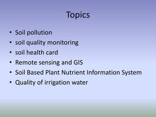
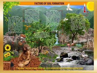
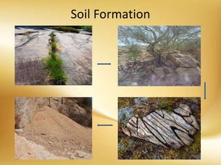
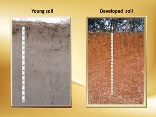
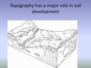
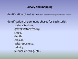
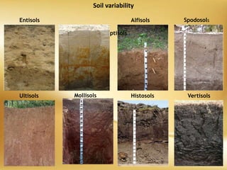
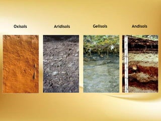
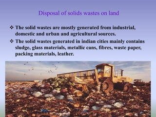
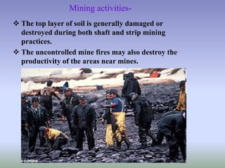
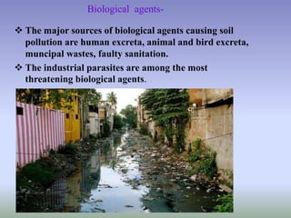
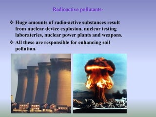
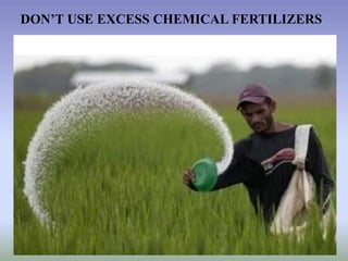
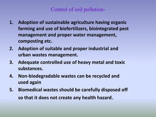
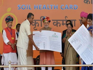
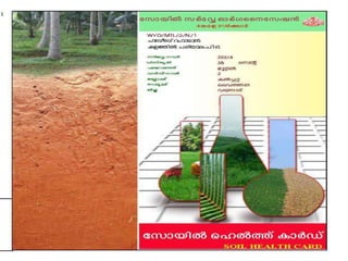
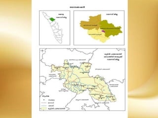
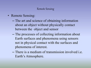
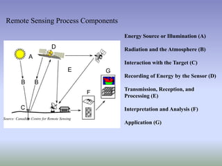
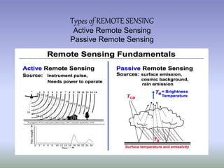
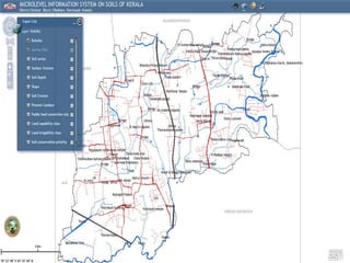
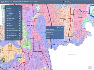
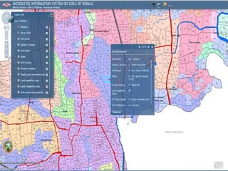
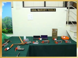
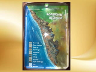
HEALTHY SOILS FOR A HEALTHY LIFE
Sudhis Kumar. K
Assistant Director –SS-NC
Department of Soil Survey & Soil Conservation
Topics
• Soil pollution
• soil quality monitoring
• soil health card
• Remote sensing and GIS
• Soil Based Plant Nutrient Information System
• Quality of irrigation water
Soil
The unconsolidated mineral or organic
material on the immediate surface of
the Earth that serves as a natural
medium for the growth of plants.
Soil Formation
Young soil Developed soil
Soil Survey
• Soil survey is the study and mapping of soils in
their natural environment
• It is the systematic examination, description,
classification and mapping of soils in an area
SOIL SURVEY
A soil survey describes the characteristics of the soils,
classifies them, plots the boundaries of the soils on an
appropriate base map, and makes predictions about the
behavior of soils.
Thus soil survey provide basic information on soils for
planning developmental programmes.
KINDS OF SOIL SURVEYS
1. Detailed soil survey
Low intensity detailed soil survey
High intensity detailed soil survey
2. Reconnaissance soil survey
3. Detailed-Reconnaissance soil survey
Field survey and mapping (Detailed soil survey)
Identification and location of survey area on soil and cadastral
maps,
Traverse the area and identify correctly the field plots
and subplots by starting from a known point present both on
map and field,
Selection and location of transects,
Study and classification of profiles,
Preparation of preliminary soil mapping legend,
Topography has a major role in soil
development
Survey and mapping
Identification of soil series –have same differentiating characters and horizons
Identification of dominant phases for each series,
surface texture,
gravelly/stony/rocky,
slope,
depth,
erosion,
calcareousness,
salinity,
Surface crusting, etc.,
Entisols
Mollisols
Alfisols Spodosols
Ultisols
Inceptisols
Histosols Vertisols
Soil variability
Oxisols Aridisols Gelisols Andisols
Soil Pollution
Soil, and pollution
POLLUTION-
An undesirable change in the physical chemical or biological
characteristics of air, water or soil.
SOIL POLLUTION-
The undesirable change in physical, chemical and biological
characteristics of soil, which are harmful for all living beings.
KINDS OF SOIL POLLUTION-
1) Agricultural pesticides
2) Disposal of solid wastes on land
3) Mining activities
4) Biological agents
5) Radioactive pollutants
6) Heavy metal pollutants
Agricultural practices-
 The use of indiscriminate use of inorganic nutrients
for a long time gradually declines the soil fertility.
 The intensive inappropriate tillage practices lowers
the capability of soil.
Disposal of solids wastes on land
 The solid wastes are mostly generated from industrial,
domestic and urban and agricultural sources.
 The solid wastes generated in indian cities mainly contains
sludge, glass materials, metallic cans, fibres, waste paper,
packing materials, leather.
Mining activities-
 The top layer of soil is generally damaged or
destroyed during both shaft and strip mining
practices.
 The uncontrolled mine fires may also destroy the
productivity of the areas near mines.
Biological agents-
 The major sources of biological agents causing soil
pollution are human excreta, animal and bird excreta,
muncipal wastes, faulty sanitation.
 The industrial parasites are among the most
threatening biological agents.
Radioactive pollutants-
 Huge amounts of radio-active substances result
from nuclear device explosion, nuclear testing
laborateries, nuclear power plants and weapons.
 All these are responsible for enhancing soil
pollution.
Heavy metal pollutants
• Heavy metals in soil are basically due to industrial discharges.
• Certain heavy metals eg. Zn, Cu, Ni, Cd and Pb are also
present in significant levels in sewage sludge and reach the soil
where they become part of life cycle and affects adversely.
DON’T USE EXCESS CHEMICAL FERTILIZERS
DON’T USE EXCESS CHEMICAL PESTICIDE
Effects of soil pollution
1. Soil fertility is adversely affected if pesticide remain in
soil for longer period.
2. Excessive use of fertilizers and pesticide chemicals does
not allow microbial flora and fauna in soil to flourish.
3. Excessive use of nitrogen and phosphatic fertilizer makes
the soil deficient in other micronutrients like Zn, Cu etc.
and causes nutrition imbalance.
4. Pesticides like DDT, dieldrin etc. are known to seep
gradually through soil into ground water and thus
contaminate public drinking water supplies.
5. People in contact with pesticides are extremely prone
to get poisoned.
6. Some of the industrial wastes are extremely toxic for
organisms.
7. Solid urban wastes and industrial wastes produce foul
and offensive odour.
8. Heavy metals and other toxic substances can destroy
benefecial microorganisms of the soil.
9. Radioactive pollutants can cause a number of
undesirable disease of digestive system if they enter
our body through food chain.
Control of soil pollution-
1. Adoption of sustainable agriculture having organic
farming and use of biofertilizers, biointegrated pest
management and proper water management,
composting etc.
2. Adoption of suitable and proper industrial and
urban wastes management.
3. Adequate controlled use of heavy metal and toxic
substances.
4. Non-biodegradable wastes can be recycled and
used again
5. Biomedical wastes should be carefully disposed off
so that it does not create any health hazard.
Soil Mapping Using
Remote Sensing Techniques
• Remote Sensing:
– The art and science of obtaining information
about an object without physically contact
between the object and sensor
– The processes of collecting information about
Earth surfaces and phenomena using sensors
not in physical contact with the surfaces and
phenomena of interest.
– There is a medium of transmission involved i.e.
Earth’s Atmosphere.
Remote Sensing
Energy Source or Illumination (A)
Radiation and the Atmosphere (B)
Interaction with the Target (C)
Recording of Energy by the Sensor (D)
Transmission, Reception, and
Processing (E)
Interpretation and Analysis (F)
Application (G)
Source: Canadian Centre for Remote Sensing
Remote Sensing Process Components
Types of REMOTE SENSING
Active Remote Sensing
Passive Remote Sensing
• Agriculture
• Forestry
• Geology
• Hydrology
• Sea Ice
• Land Cover & Land Use
• Mapping
• Oceans & Coastal Monitoring
Area:
APPLICATION:
Source: Jensen (2000)
Application Domain
 Urbanization & Transportation
◦ Updating road maps
◦ Asphalt conditions
◦ Wetland delineation
 Agriculture
◦ Crop health analysis
◦ Precision agriculture
◦ Compliance mapping
◦ Yield estimation
 Natural Resource Management
◦ Habitat analysis
◦ Environmental assessment
◦ Pest/disease outbreaks
◦ Impervious surface mapping
◦ Lake monitoring
◦ Hydrology
◦ Landuse - Landcover monitoring
◦ Mineral province
◦ Geomorphology
Applications of remote sensing and GIS
Agriculture
• Crop acreage estimation
• Crop modeling for yield &
production forecast / estimation
• Crop & Orchard monitoring
Scope
• Timely availability of crop
statistics for decision making &
planning
• Crop growth monitoring
• Soil status monitoring
• Regular reports regarding total
area under cultivation
Benefits
Banana Plantation – Muhammad Pur (Ghotki)
FFC Goth Macchi
Mar 05, 2006, RecoveryJan 12, 2006, DamageDec 16, 2005, Pre-Frost
Forestry
• Satellite image based forest
resource mapping and updation
• Forest change detection
• Forest resource inventory
• GIS database development
Scope
• Availability of baseline information
• Planning for aforestation strategies
• Futuristic resource planning
• Sustainability of environment
• Wild life conservation & development
for recreation purpose
Benefits Sarhad Reserve Forest (Ghotki)
Nausharo
Firoz
Landuse / Landcover Mapping
• Monitoring dynamic changes
• Urban/Rural infrastructure
• Waterlogging & salinity
Scope
• Assessment of spatial distribution of
land resources
• Infrastructure monitoring
• Availability of usable land
• Future planning for better land
management for socio-economic
development
Benefits
• Use of Remote Sensing and GIS technology in these areas of
sustainable agricultural management.
•
Cropping System Analysis
Cropping system map generated through integrated use of temporal digital satellite data and GIS
Urban & Regional Planning
• Mapping & updation of
city/town maps
• Urban sprawl monitoring
• Town planning
• Facility management
• GIS database development
Scope
• Better decision support, planning
& management
• Rapid information updation
• Infrastructure development
monitoring
• Spatial information analysis
Benefits
What is GIS?
• GIS = Geographic Information System
– Links databases and maps
– Manages information about places
– Helps answer questions such as:
• Where is it?
• What else is nearby?
• Where is the highest concentration of ‘X’?
• Where can I find things with characteristic ‘Y’?
• Where is the closest ‘Z’ to my location?
• Geographic Information System
• A GIS is a computer system capable of capturing,
storing, analyzing, and displaying geographically
referenced information; that is, data identified
according to location.
• Practitioners also define a GIS as including the
procedures, operating personnel, and spatial data that
go into the system.
What is a GIS?
• A GIS makes it possible to link, or integrate,
information that is difficult to associate through any
other means.
• Thus, a GIS can use combinations of mapped
variables to build and analyze new variables.
• GIS is most useful when used to perform data
analysis
Why Does GIS Matter?
“Almost everything that happens, happens
somewhere. Knowing where something
happens is critically important.”
Longley et al. (2001, 6)
Because location is so important, it is an issue in
many of the problems
• the real world has a lot of spatial data
– manipulation, analysis and modeling can be effective
and efficiently carried out with a GIS
• the neighborhood of the intended purchase of house
• the route for fire-fighting vehicles to the fire area
• location of historical sites to visit
• the earth surface for purposes of army
• the earth surface is a limited resource
• rational decisions on space utilization
• fast and quality information in decision making
THE NEED FOR GIS
 complexity of management
– due to the need to combine and process many
sets of data, in addition to judge as many as
possible, situation that might happen.
 intense competition
– the need to use technology in making decisions
and strategy in the world of intense
competition.
... THE NEED FOR GIS
GIS
USES
VARIOUS DATA
SOURCES
VARIOUS DATA
FORMATS
AND
MAPS IMAGE
DIGITAL
PRODUCTS
GPS
TEXT
DATA
TABULAR
DATA
MAPS
DATABASE
REPORTS
1
2
4 43
Basic functions of GIS
•Data Acquisition and prepossessing
•Database Management and Retrieval
•Spatial Measurement and Analysis
•Graphic output and Visualization
• Maximize the efficiency of planning and decision
making
• Provide efficient means for data distribution and
handling
• Elimination of redundant data base - minimize
duplication
• Capacity to integrate information from many sources
• Complex analysis/query involving geographical
referenced data to generate
GIS OBJECTIVES
Geospatial data are better maintained in a standard
format.
Revision and updating are easier.
Geospatial data and information are easier to search,
analysis and represent.
More value added product.
Geospatial data can be shared and exchanged freely.
Productivity of the staff improved and more efficient.
Time and money are saved.
Better decision can be made.
 Facilities Management:
 Locating underground pipes & cables, planning facility
maintenance, telecommunication network services
 Environmental and Natural Resources Management:
Environmental impact analysis, disaster management and
mitigation
 Street Network:
 Locating houses and streets, car navigation, transportation planning
 Planning and Engineering:
 Urban planning, regional planning, development of public facilities
 Land Information:
 Taxation, zoning of land use, land acquisition
Area:
GIS Application:
Courses conducted at the
Directorate of Soil Survey and Soil Conservation
• Basics of Remote sensing and GIS & Global Navigation System
• Applications of RS & GIS for Natural Resources
• Applications of Microwave Remote Sensing for Natural Resource
Management
• Contact Number 0471 2339800
Irrigation water quality
Water Uses
Use Typical quality parameters
Public Water Supply Turbidity, TDS, inorganic and
organic compounds, microbes
Water contact recreation Turbidity, bacteria, toxic
compounds
Fish propagation and wildlife DO, chlorinated organic
compounds
Industrial water supply Suspended and dissolved
constituents
Agricultural water supply Sodium, TDS
Shellfish harvesting DO, bacteria
Basic Water Quality Parameters
• pH
• Specific conductance (EC)
• Salinity
• Total dissolved solids (TDS)
• Turbidity
• Dissolved oxygen (DO)
• Biochemical oxygen demand (BOD)
• Temperature
pH
• Measures hydrogen ion
concentration
• Negative log of hydrogen ion
concentration
• Ranges from 0 to 14 std. units
• pH
– 7 neutral
– 0 - 7 acidic
– 7 - 14 alkaline
Thanks to Phil Brown
Solubility of Specific Ions
Based on Water pH
Toxic metals less available in water at pH 6 to 8.
Conductivity
• Measures electric
conductivity (EC) of water
• Higher value means water
is a better electrical
conductor
• Increases when more salt
(e.g., sodium chloride) is
dissolved in water
• Indirect measure of salinity
• Units are μmhos/cm at 25o
C or μsiemens/cm
Thanks to Phil Brown
Salinity
• Classification of Ground Water
• Composition Based on Total Dissolved
Solids Content
Salts in Sea Water
Type of Water Dissolved salt content (mg/l)
Fresh water < 1,000 mg/l
Brackish water 1,000 - 3,000 mg/l
Moderatly saline
water
3,000 - 10,000 mg/l
Highly saline water 10,000 - 35,000 mg/l
Sea water > 35,000 mg/l
Salinity and irrigation
• Low salinity water
– used for most crops
• Medium salinity water
– used with moderate amount of leaching (potatoes,
corn, wheat, oats, and alfalfa)
• High salinity water
– Cannot be used on soils having restricted drainage.
• Very high salinity water
– Can be used only on certain crops only if special
practices are followed
Designated-Best-Use Class of water Criteria
Drinking Water Source without
conventional treatment but after
disinfection
A
 Total Coliforms Organism MPN/100ml shall be 50 or less
 pH between 6.5 and 8.5
 Dissolved Oxygen 6mg/l or more
 Biochemical Oxygen Demand 5 days 20°C 2mg/l or less
Outdoor bathing (Organised) B
 Total Coliforms Organism MPN/100ml shall be 500 or less pH
between 6.5 and 8.5 Dissolved Oxygen 5mg/l or more
 Biochemical Oxygen Demand 5 days 20°C 3mg/l or less
Drinking water source after
conventional treatment and disinfection C
 Total Coliforms Organism MPN/100ml shall be 5000 or less
pH between 6 to 9 Dissolved Oxygen 4mg/l or more
 Biochemical Oxygen Demand 5 days 20°C 3mg/l or less
Propagation of Wild life and Fisheries D
 pH between 6.5 to 8.5 Dissolved Oxygen 4mg/l or more
 Free Ammonia (as N) 1.2 mg/l or less
Irrigation, Industrial Cooling, Controlled
Waste disposal E
 pH betwwn 6.0 to 8.5
 Electrical Conductivity at 25°C micro mhos/cm Max.2250
 Sodium absorption Ratio Max. 26
 Boron Max. 2mg/l
Below-E Not Meeting A, B, C, D & E Criteria
Standards fixed by Central Pollution Control Board
• Soil Based Plant Nutrient Information System
ksudhiskumar@gmail.com
94957 79388

SUDHISH SIR CLASS

  • 1.
    HEALTHY SOILS FORA HEALTHY LIFE Sudhis Kumar. K Assistant Director –SS-NC Department of Soil Survey & Soil Conservation
  • 3.
    Topics • Soil pollution •soil quality monitoring • soil health card • Remote sensing and GIS • Soil Based Plant Nutrient Information System • Quality of irrigation water
  • 4.
    Soil The unconsolidated mineralor organic material on the immediate surface of the Earth that serves as a natural medium for the growth of plants.
  • 6.
  • 7.
  • 8.
    Soil Survey • Soilsurvey is the study and mapping of soils in their natural environment • It is the systematic examination, description, classification and mapping of soils in an area
  • 9.
    SOIL SURVEY A soilsurvey describes the characteristics of the soils, classifies them, plots the boundaries of the soils on an appropriate base map, and makes predictions about the behavior of soils. Thus soil survey provide basic information on soils for planning developmental programmes.
  • 10.
    KINDS OF SOILSURVEYS 1. Detailed soil survey Low intensity detailed soil survey High intensity detailed soil survey 2. Reconnaissance soil survey 3. Detailed-Reconnaissance soil survey
  • 11.
    Field survey andmapping (Detailed soil survey) Identification and location of survey area on soil and cadastral maps, Traverse the area and identify correctly the field plots and subplots by starting from a known point present both on map and field, Selection and location of transects, Study and classification of profiles, Preparation of preliminary soil mapping legend,
  • 12.
    Topography has amajor role in soil development
  • 13.
    Survey and mapping Identificationof soil series –have same differentiating characters and horizons Identification of dominant phases for each series, surface texture, gravelly/stony/rocky, slope, depth, erosion, calcareousness, salinity, Surface crusting, etc.,
  • 14.
  • 15.
  • 16.
  • 17.
    Soil, and pollution POLLUTION- Anundesirable change in the physical chemical or biological characteristics of air, water or soil. SOIL POLLUTION- The undesirable change in physical, chemical and biological characteristics of soil, which are harmful for all living beings.
  • 18.
    KINDS OF SOILPOLLUTION- 1) Agricultural pesticides 2) Disposal of solid wastes on land 3) Mining activities 4) Biological agents 5) Radioactive pollutants 6) Heavy metal pollutants
  • 19.
    Agricultural practices-  Theuse of indiscriminate use of inorganic nutrients for a long time gradually declines the soil fertility.  The intensive inappropriate tillage practices lowers the capability of soil.
  • 20.
    Disposal of solidswastes on land  The solid wastes are mostly generated from industrial, domestic and urban and agricultural sources.  The solid wastes generated in indian cities mainly contains sludge, glass materials, metallic cans, fibres, waste paper, packing materials, leather.
  • 21.
    Mining activities-  Thetop layer of soil is generally damaged or destroyed during both shaft and strip mining practices.  The uncontrolled mine fires may also destroy the productivity of the areas near mines.
  • 22.
    Biological agents-  Themajor sources of biological agents causing soil pollution are human excreta, animal and bird excreta, muncipal wastes, faulty sanitation.  The industrial parasites are among the most threatening biological agents.
  • 23.
    Radioactive pollutants-  Hugeamounts of radio-active substances result from nuclear device explosion, nuclear testing laborateries, nuclear power plants and weapons.  All these are responsible for enhancing soil pollution.
  • 24.
    Heavy metal pollutants •Heavy metals in soil are basically due to industrial discharges. • Certain heavy metals eg. Zn, Cu, Ni, Cd and Pb are also present in significant levels in sewage sludge and reach the soil where they become part of life cycle and affects adversely.
  • 25.
    DON’T USE EXCESSCHEMICAL FERTILIZERS
  • 26.
    DON’T USE EXCESSCHEMICAL PESTICIDE
  • 27.
    Effects of soilpollution 1. Soil fertility is adversely affected if pesticide remain in soil for longer period. 2. Excessive use of fertilizers and pesticide chemicals does not allow microbial flora and fauna in soil to flourish. 3. Excessive use of nitrogen and phosphatic fertilizer makes the soil deficient in other micronutrients like Zn, Cu etc. and causes nutrition imbalance. 4. Pesticides like DDT, dieldrin etc. are known to seep gradually through soil into ground water and thus contaminate public drinking water supplies.
  • 28.
    5. People incontact with pesticides are extremely prone to get poisoned. 6. Some of the industrial wastes are extremely toxic for organisms. 7. Solid urban wastes and industrial wastes produce foul and offensive odour. 8. Heavy metals and other toxic substances can destroy benefecial microorganisms of the soil. 9. Radioactive pollutants can cause a number of undesirable disease of digestive system if they enter our body through food chain.
  • 29.
    Control of soilpollution- 1. Adoption of sustainable agriculture having organic farming and use of biofertilizers, biointegrated pest management and proper water management, composting etc. 2. Adoption of suitable and proper industrial and urban wastes management. 3. Adequate controlled use of heavy metal and toxic substances. 4. Non-biodegradable wastes can be recycled and used again 5. Biomedical wastes should be carefully disposed off so that it does not create any health hazard.
  • 39.
    Soil Mapping Using RemoteSensing Techniques
  • 40.
    • Remote Sensing: –The art and science of obtaining information about an object without physically contact between the object and sensor – The processes of collecting information about Earth surfaces and phenomena using sensors not in physical contact with the surfaces and phenomena of interest. – There is a medium of transmission involved i.e. Earth’s Atmosphere. Remote Sensing
  • 41.
    Energy Source orIllumination (A) Radiation and the Atmosphere (B) Interaction with the Target (C) Recording of Energy by the Sensor (D) Transmission, Reception, and Processing (E) Interpretation and Analysis (F) Application (G) Source: Canadian Centre for Remote Sensing Remote Sensing Process Components
  • 42.
    Types of REMOTESENSING Active Remote Sensing Passive Remote Sensing
  • 46.
    • Agriculture • Forestry •Geology • Hydrology • Sea Ice • Land Cover & Land Use • Mapping • Oceans & Coastal Monitoring Area: APPLICATION:
  • 47.
  • 48.
     Urbanization &Transportation ◦ Updating road maps ◦ Asphalt conditions ◦ Wetland delineation  Agriculture ◦ Crop health analysis ◦ Precision agriculture ◦ Compliance mapping ◦ Yield estimation  Natural Resource Management ◦ Habitat analysis ◦ Environmental assessment ◦ Pest/disease outbreaks ◦ Impervious surface mapping ◦ Lake monitoring ◦ Hydrology ◦ Landuse - Landcover monitoring ◦ Mineral province ◦ Geomorphology Applications of remote sensing and GIS
  • 49.
    Agriculture • Crop acreageestimation • Crop modeling for yield & production forecast / estimation • Crop & Orchard monitoring Scope • Timely availability of crop statistics for decision making & planning • Crop growth monitoring • Soil status monitoring • Regular reports regarding total area under cultivation Benefits Banana Plantation – Muhammad Pur (Ghotki) FFC Goth Macchi Mar 05, 2006, RecoveryJan 12, 2006, DamageDec 16, 2005, Pre-Frost
  • 50.
    Forestry • Satellite imagebased forest resource mapping and updation • Forest change detection • Forest resource inventory • GIS database development Scope • Availability of baseline information • Planning for aforestation strategies • Futuristic resource planning • Sustainability of environment • Wild life conservation & development for recreation purpose Benefits Sarhad Reserve Forest (Ghotki) Nausharo Firoz
  • 51.
    Landuse / LandcoverMapping • Monitoring dynamic changes • Urban/Rural infrastructure • Waterlogging & salinity Scope • Assessment of spatial distribution of land resources • Infrastructure monitoring • Availability of usable land • Future planning for better land management for socio-economic development Benefits
  • 52.
    • Use ofRemote Sensing and GIS technology in these areas of sustainable agricultural management. • Cropping System Analysis Cropping system map generated through integrated use of temporal digital satellite data and GIS
  • 53.
    Urban & RegionalPlanning • Mapping & updation of city/town maps • Urban sprawl monitoring • Town planning • Facility management • GIS database development Scope • Better decision support, planning & management • Rapid information updation • Infrastructure development monitoring • Spatial information analysis Benefits
  • 54.
    What is GIS? •GIS = Geographic Information System – Links databases and maps – Manages information about places – Helps answer questions such as: • Where is it? • What else is nearby? • Where is the highest concentration of ‘X’? • Where can I find things with characteristic ‘Y’? • Where is the closest ‘Z’ to my location?
  • 55.
    • Geographic InformationSystem • A GIS is a computer system capable of capturing, storing, analyzing, and displaying geographically referenced information; that is, data identified according to location. • Practitioners also define a GIS as including the procedures, operating personnel, and spatial data that go into the system. What is a GIS?
  • 56.
    • A GISmakes it possible to link, or integrate, information that is difficult to associate through any other means. • Thus, a GIS can use combinations of mapped variables to build and analyze new variables. • GIS is most useful when used to perform data analysis
  • 57.
    Why Does GISMatter? “Almost everything that happens, happens somewhere. Knowing where something happens is critically important.” Longley et al. (2001, 6) Because location is so important, it is an issue in many of the problems
  • 58.
    • the realworld has a lot of spatial data – manipulation, analysis and modeling can be effective and efficiently carried out with a GIS • the neighborhood of the intended purchase of house • the route for fire-fighting vehicles to the fire area • location of historical sites to visit • the earth surface for purposes of army • the earth surface is a limited resource • rational decisions on space utilization • fast and quality information in decision making THE NEED FOR GIS
  • 59.
     complexity ofmanagement – due to the need to combine and process many sets of data, in addition to judge as many as possible, situation that might happen.  intense competition – the need to use technology in making decisions and strategy in the world of intense competition. ... THE NEED FOR GIS
  • 60.
    GIS USES VARIOUS DATA SOURCES VARIOUS DATA FORMATS AND MAPSIMAGE DIGITAL PRODUCTS GPS TEXT DATA TABULAR DATA MAPS DATABASE REPORTS 1 2 4 43
  • 61.
    Basic functions ofGIS •Data Acquisition and prepossessing •Database Management and Retrieval •Spatial Measurement and Analysis •Graphic output and Visualization
  • 62.
    • Maximize theefficiency of planning and decision making • Provide efficient means for data distribution and handling • Elimination of redundant data base - minimize duplication • Capacity to integrate information from many sources • Complex analysis/query involving geographical referenced data to generate GIS OBJECTIVES
  • 63.
    Geospatial data arebetter maintained in a standard format. Revision and updating are easier. Geospatial data and information are easier to search, analysis and represent. More value added product. Geospatial data can be shared and exchanged freely. Productivity of the staff improved and more efficient. Time and money are saved. Better decision can be made.
  • 64.
     Facilities Management: Locating underground pipes & cables, planning facility maintenance, telecommunication network services  Environmental and Natural Resources Management: Environmental impact analysis, disaster management and mitigation  Street Network:  Locating houses and streets, car navigation, transportation planning  Planning and Engineering:  Urban planning, regional planning, development of public facilities  Land Information:  Taxation, zoning of land use, land acquisition Area: GIS Application:
  • 65.
    Courses conducted atthe Directorate of Soil Survey and Soil Conservation • Basics of Remote sensing and GIS & Global Navigation System • Applications of RS & GIS for Natural Resources • Applications of Microwave Remote Sensing for Natural Resource Management • Contact Number 0471 2339800
  • 66.
  • 67.
    Water Uses Use Typicalquality parameters Public Water Supply Turbidity, TDS, inorganic and organic compounds, microbes Water contact recreation Turbidity, bacteria, toxic compounds Fish propagation and wildlife DO, chlorinated organic compounds Industrial water supply Suspended and dissolved constituents Agricultural water supply Sodium, TDS Shellfish harvesting DO, bacteria
  • 68.
    Basic Water QualityParameters • pH • Specific conductance (EC) • Salinity • Total dissolved solids (TDS) • Turbidity • Dissolved oxygen (DO) • Biochemical oxygen demand (BOD) • Temperature
  • 69.
    pH • Measures hydrogenion concentration • Negative log of hydrogen ion concentration • Ranges from 0 to 14 std. units • pH – 7 neutral – 0 - 7 acidic – 7 - 14 alkaline Thanks to Phil Brown
  • 70.
    Solubility of SpecificIons Based on Water pH Toxic metals less available in water at pH 6 to 8.
  • 71.
    Conductivity • Measures electric conductivity(EC) of water • Higher value means water is a better electrical conductor • Increases when more salt (e.g., sodium chloride) is dissolved in water • Indirect measure of salinity • Units are μmhos/cm at 25o C or μsiemens/cm Thanks to Phil Brown
  • 72.
    Salinity • Classification ofGround Water • Composition Based on Total Dissolved Solids Content Salts in Sea Water Type of Water Dissolved salt content (mg/l) Fresh water < 1,000 mg/l Brackish water 1,000 - 3,000 mg/l Moderatly saline water 3,000 - 10,000 mg/l Highly saline water 10,000 - 35,000 mg/l Sea water > 35,000 mg/l
  • 73.
    Salinity and irrigation •Low salinity water – used for most crops • Medium salinity water – used with moderate amount of leaching (potatoes, corn, wheat, oats, and alfalfa) • High salinity water – Cannot be used on soils having restricted drainage. • Very high salinity water – Can be used only on certain crops only if special practices are followed
  • 74.
    Designated-Best-Use Class ofwater Criteria Drinking Water Source without conventional treatment but after disinfection A  Total Coliforms Organism MPN/100ml shall be 50 or less  pH between 6.5 and 8.5  Dissolved Oxygen 6mg/l or more  Biochemical Oxygen Demand 5 days 20°C 2mg/l or less Outdoor bathing (Organised) B  Total Coliforms Organism MPN/100ml shall be 500 or less pH between 6.5 and 8.5 Dissolved Oxygen 5mg/l or more  Biochemical Oxygen Demand 5 days 20°C 3mg/l or less Drinking water source after conventional treatment and disinfection C  Total Coliforms Organism MPN/100ml shall be 5000 or less pH between 6 to 9 Dissolved Oxygen 4mg/l or more  Biochemical Oxygen Demand 5 days 20°C 3mg/l or less Propagation of Wild life and Fisheries D  pH between 6.5 to 8.5 Dissolved Oxygen 4mg/l or more  Free Ammonia (as N) 1.2 mg/l or less Irrigation, Industrial Cooling, Controlled Waste disposal E  pH betwwn 6.0 to 8.5  Electrical Conductivity at 25°C micro mhos/cm Max.2250  Sodium absorption Ratio Max. 26  Boron Max. 2mg/l Below-E Not Meeting A, B, C, D & E Criteria Standards fixed by Central Pollution Control Board
  • 75.
    • Soil BasedPlant Nutrient Information System
  • 95.