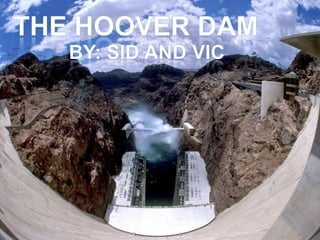
the seminar presentation on hoover dam.
how it was constructed and its project management, time management, cost management, and its tunnels and penstocks and so on.....
Open channel Flow -Class lectures at WUB, Book references, Mission and Vision, CO and PO, definition of OCF, Aplication of Hydraulics, ,Difference between OCF and Pipe flow, Classification, Flow profile and cross sections.
Canal & canal types with design of channels by dj sir covered kennedy lacey t...Denish Jangid
Canal its types with design of channels by Denish Jangid sir.
covered kennedy lacey theory IS code method with comparison drawbacks.
design steps by kennedy
design steps by lacey
design of canal types of canal trapezoidal shape. Canal Irrigation. Subject-
Water Resources Engineering By Dr.* Denish Jangid Assistant Professor Civil Engineering Department
Canal Classification based on Financial returns
Canal Classification based on Use
Canal Classification based on Size
Cana Masonry work
alluvial soil
Cross regulator
Head regulator
Silt Control device
Silt ejector
Silt excluder
Factor affecting the Canal Alignment
A contour canal is an artificially-dug navigable canal which closely follows the contour line of the land it traverses in order to avoid costly engineering works such as boring a tunnel through higher ground, building an embankment over lower ground, or constructing a canal lock (or series of locks) to change the level of the canal. Because of this, these canals are characterized by their meandering course.
Step Determine the depth D and bed width B from values of A & P
Cost of construction including cross drainage works should be minimized. .A shorter length of canal ensures less loss of head due to friction and smaller loss of discharge due to seepage and evaporation, so that additional area may be brought under cultivation. A canal may be aligned as a contour canal, a side slope canal or a ridge canal according to the type of terrain and culturable area. A contour canal irrigate areas only on one side of the canal. Where canal crosses valleys, different types of cross drainage works are required. A side slope canal is aligned at 90 degree to the contours of the region. A watershed or ridge canal irrigate areas on both sides. Cross drainage works are eliminated in case of ridge and side slope. Main canal is generally carried on a contour alignment. Branch and distributaries take off from a canal from or near the points where the canal crosses the watershed. All possible alignments should be studied and the best suited alignment should be selected. Number of rinks and acute curves should be minimized. They should be aligned as far as possible in partial cutting partial filling. Deep cutting should be avoided by comparing the overall cost of alternative alignments.
The new Bandra-Worli Sea Link is a symbol of the great advances of the economy and engineering capabilities
of the India which is reflection of modern infrastructure.
Case study of the Quebec Bridge Collapse, the only bridge with two tragedies during its construction. Causes of failure and the lessons learned from the same.
Types- selection of the suitable site for the diversion headwork components
of diversion headwork- Causes of failure of structure on pervious foundation- Khosla’s theory- Design of concrete sloping
glacis weir.
Concrete Gravity Dam Components
A gallery is a small passage in a dam for providing an access to the interior of the dam.
The gallery is usually rectangular in shape with its top and bottom either flat or semi circular.
For a gallery with its top and bottom flat, it is necessary that all the corners should be rounded. The width of gallery generally varies from 1.5 to 1.8 m. The height of the gallery in between 2.2 to 2.4 m, so that a person can easily walk inside it.
To provide drainage of the dam section.
2. To provide space for equipment required for drilling holes and grouting the hole to form a grout curtain in the foundation.
3. To provide space for header and return pipes for post cooling of concrete.
4. A gallery provide an access to the interior of the dam for inspection ard maintenance.
5. A Gallery also provides space for installing various instruments in the dam to study its structural behaviour.
6. A gallery can provide space for the mechanical and electrical equipment required for the operation of gates for spillways and outlets.
A shaft is a vertical opening provided in a dam. Shafts are required for locating headers of the post cooling system and for locating measuring devices.
Shafts are also required for the movement of elevators and the hoisting equipment. Sometimes shafts are constructed inclined to connect two galleries or the same gallery at two different elevations by a staircase or a lift arrangement.
A plumb line shaft is constructed at the maximum section of the dam to make observations of the deflection of the dam under loads.
A plumb bob is suspended by a wire fixed at the top of the shaft. As the dam deflects relative to the base, the plumb bob also moves by the same amount.
A stilling well shaft is a special shaft used to record fluctuations of the water level in the reservoir. The shaft is connected to the reservoir at a point below the minimum reservoir level.
There is a floating mechanism in the stilling well shaft which records fluctuations in the water level.
The spillway in a gravity dam is called overflow section. Spillway is provided to dispose of surplus water from the reservoir to the downstream.
Spillways are provided for all dams as a safety measure against overtopping and the consequent damages, and failure. spillway may be located either in the middle of the dam or at the end of the dam near abutment.
It must have adequate discharge capacity.
It must be hydraulically and structurally safe.
The surface of the spillway must be erosion resistant.
It should be provided with some device for the dissipation of excess energy
The portion of the gravity dam other than the spillway is a non-overflow section, a road is located on the non-overflow section of the dam.
At the one end of a gravity dam a power house is located. Water from the reservoir passes tnrough penstock and rotates the turbine provided at power elevations to produce electricity.
Water flowing over a spillway has a ver
http://www.scenic.com/tours/hoover-dam-bus-tour | Learn the fascinating history of Hoover Dam and its construction. See why it is the most-visited dam in the world. Together with Lake Mead and the nearby Hoover Dam Bypass Bridge, it manages water flow from the mighty Colorado River into three surrounding states.
Sigma Xi, The Scientific Research SocietyEngineering HoovWilheminaRossi174
Sigma Xi, The Scientific Research Society
Engineering: Hoover Dam
Author(s): Henry Petroski
Reviewed work(s):
Source: American Scientist, Vol. 81, No. 6 (November-December 1993), pp. 517-521
Published by: Sigma Xi, The Scientific Research Society
Stable URL: http://www.jstor.org/stable/29775051 .
Accessed: 06/01/2013 08:28
Your use of the JSTOR archive indicates your acceptance of the Terms & Conditions of Use, available at .
http://www.jstor.org/page/info/about/policies/terms.jsp
.
JSTOR is a not-for-profit service that helps scholars, researchers, and students discover, use, and build upon a wide range of
content in a trusted digital archive. We use information technology and tools to increase productivity and facilitate new forms
of scholarship. For more information about JSTOR, please contact [email protected]
.
Sigma Xi, The Scientific Research Society is collaborating with JSTOR to digitize, preserve and extend access
to American Scientist.
http://www.jstor.org
This content downloaded on Sun, 6 Jan 2013 08:28:00 AM
All use subject to JSTOR Terms and Conditions
http://www.jstor.org/action/showPublisher?publisherCode=sigmaxi
http://www.jstor.org/stable/29775051?origin=JSTOR-pdf
http://www.jstor.org/page/info/about/policies/terms.jsp
http://www.jstor.org/page/info/about/policies/terms.jsp
Hoover Dam
Henry Petroski
Everything seems to move slowly at Hoover
Dam. Long lines of cars, buses and trucks in
low gear wind along the two-lane road
down one steep side of Black Canyon and up the
other. The lines stop frequently as carloads of
tourists crane their necks at the grandeur of the
site, and drivers search for a parking space
among the tiers of overlooks. For all the conges?
tion, few motorists seem impatient or interested
in searching maps for alternate routes. Everyone
driving in this vicinity must know that U.S. High?
way 95, which arcs along the crest of the dam, is
the only road across the Colorado River between
Davis Dam, over 50 miles to the south, and Nava
jo Bridge, over 150 miles to the east.
Pedestrians move about the top of the dam at a
snail's pace in the desert heat, crisscrossing the
crest over which, by design, no water has ever
flowed. Several thousand tourists may visit
Hoover Dam on a summer day, most of them
standing in long lines to board the large elevator
that takes them, 20 at a time, 600 feet down into
the inner workings of the dam. Many come from
Las Vegas, 35 miles to the northwest. Even there,
amid all the noise and neon, a visit to Hoover
Dam is hawked as one of the area's must-do
things. The pitch may be engineering achieve?
ment as awesome entertainment, but few who
visit the works at Black Canyon seem disappoint?
ed by the decided calmness and harmony of it all.
Just as the Mississippi River wreaked havoc in
the Midwest last summer, so the Colorado River
used to be alternately a blessing and a bane for
the Southwest. Although the Colorado seemed a
pot ...
Sigma Xi, The Scientific Research SocietyEngineering Hoov.docxedgar6wallace88877
Sigma Xi, The Scientific Research Society
Engineering: Hoover Dam
Author(s): Henry Petroski
Reviewed work(s):
Source: American Scientist, Vol. 81, No. 6 (November-December 1993), pp. 517-521
Published by: Sigma Xi, The Scientific Research Society
Stable URL: http://www.jstor.org/stable/29775051 .
Accessed: 06/01/2013 08:28
Your use of the JSTOR archive indicates your acceptance of the Terms & Conditions of Use, available at .
http://www.jstor.org/page/info/about/policies/terms.jsp
.
JSTOR is a not-for-profit service that helps scholars, researchers, and students discover, use, and build upon a wide range of
content in a trusted digital archive. We use information technology and tools to increase productivity and facilitate new forms
of scholarship. For more information about JSTOR, please contact [email protected]
.
Sigma Xi, The Scientific Research Society is collaborating with JSTOR to digitize, preserve and extend access
to American Scientist.
http://www.jstor.org
This content downloaded on Sun, 6 Jan 2013 08:28:00 AM
All use subject to JSTOR Terms and Conditions
http://www.jstor.org/action/showPublisher?publisherCode=sigmaxi
http://www.jstor.org/stable/29775051?origin=JSTOR-pdf
http://www.jstor.org/page/info/about/policies/terms.jsp
http://www.jstor.org/page/info/about/policies/terms.jsp
Hoover Dam
Henry Petroski
Everything seems to move slowly at Hoover
Dam. Long lines of cars, buses and trucks in
low gear wind along the two-lane road
down one steep side of Black Canyon and up the
other. The lines stop frequently as carloads of
tourists crane their necks at the grandeur of the
site, and drivers search for a parking space
among the tiers of overlooks. For all the conges?
tion, few motorists seem impatient or interested
in searching maps for alternate routes. Everyone
driving in this vicinity must know that U.S. High?
way 95, which arcs along the crest of the dam, is
the only road across the Colorado River between
Davis Dam, over 50 miles to the south, and Nava
jo Bridge, over 150 miles to the east.
Pedestrians move about the top of the dam at a
snail's pace in the desert heat, crisscrossing the
crest over which, by design, no water has ever
flowed. Several thousand tourists may visit
Hoover Dam on a summer day, most of them
standing in long lines to board the large elevator
that takes them, 20 at a time, 600 feet down into
the inner workings of the dam. Many come from
Las Vegas, 35 miles to the northwest. Even there,
amid all the noise and neon, a visit to Hoover
Dam is hawked as one of the area's must-do
things. The pitch may be engineering achieve?
ment as awesome entertainment, but few who
visit the works at Black Canyon seem disappoint?
ed by the decided calmness and harmony of it all.
Just as the Mississippi River wreaked havoc in
the Midwest last summer, so the Colorado River
used to be alternately a blessing and a bane for
the Southwest. Although the Colorado seemed a
pot.
Follow the path of California's first major water project that stretched from Mono Lake to Southern California, delivering the Owens River to support the growth & population of Los Angeles.
How to Create Map Views in the Odoo 17 ERPCeline George
The map views are useful for providing a geographical representation of data. They allow users to visualize and analyze the data in a more intuitive manner.
Read| The latest issue of The Challenger is here! We are thrilled to announce that our school paper has qualified for the NATIONAL SCHOOLS PRESS CONFERENCE (NSPC) 2024. Thank you for your unwavering support and trust. Dive into the stories that made us stand out!
How to Split Bills in the Odoo 17 POS ModuleCeline George
Bills have a main role in point of sale procedure. It will help to track sales, handling payments and giving receipts to customers. Bill splitting also has an important role in POS. For example, If some friends come together for dinner and if they want to divide the bill then it is possible by POS bill splitting. This slide will show how to split bills in odoo 17 POS.
This is a presentation by Dada Robert in a Your Skill Boost masterclass organised by the Excellence Foundation for South Sudan (EFSS) on Saturday, the 25th and Sunday, the 26th of May 2024.
He discussed the concept of quality improvement, emphasizing its applicability to various aspects of life, including personal, project, and program improvements. He defined quality as doing the right thing at the right time in the right way to achieve the best possible results and discussed the concept of the "gap" between what we know and what we do, and how this gap represents the areas we need to improve. He explained the scientific approach to quality improvement, which involves systematic performance analysis, testing and learning, and implementing change ideas. He also highlighted the importance of client focus and a team approach to quality improvement.
Unit 8 - Information and Communication Technology (Paper I).pdfThiyagu K
This slides describes the basic concepts of ICT, basics of Email, Emerging Technology and Digital Initiatives in Education. This presentations aligns with the UGC Paper I syllabus.
Operation “Blue Star” is the only event in the history of Independent India where the state went into war with its own people. Even after about 40 years it is not clear if it was culmination of states anger over people of the region, a political game of power or start of dictatorial chapter in the democratic setup.
The people of Punjab felt alienated from main stream due to denial of their just demands during a long democratic struggle since independence. As it happen all over the word, it led to militant struggle with great loss of lives of military, police and civilian personnel. Killing of Indira Gandhi and massacre of innocent Sikhs in Delhi and other India cities was also associated with this movement.
The Art Pastor's Guide to Sabbath | Steve ThomasonSteve Thomason
What is the purpose of the Sabbath Law in the Torah. It is interesting to compare how the context of the law shifts from Exodus to Deuteronomy. Who gets to rest, and why?
Instructions for Submissions thorugh G- Classroom.pptxJheel Barad
This presentation provides a briefing on how to upload submissions and documents in Google Classroom. It was prepared as part of an orientation for new Sainik School in-service teacher trainees. As a training officer, my goal is to ensure that you are comfortable and proficient with this essential tool for managing assignments and fostering student engagement.
Students, digital devices and success - Andreas Schleicher - 27 May 2024..pptxEduSkills OECD
Andreas Schleicher presents at the OECD webinar ‘Digital devices in schools: detrimental distraction or secret to success?’ on 27 May 2024. The presentation was based on findings from PISA 2022 results and the webinar helped launch the PISA in Focus ‘Managing screen time: How to protect and equip students against distraction’ https://www.oecd-ilibrary.org/education/managing-screen-time_7c225af4-en and the OECD Education Policy Perspective ‘Students, digital devices and success’ can be found here - https://oe.cd/il/5yV
2. Need for the Hoover Dam The Colorado River was growing out of control Flooding increased rapidly The surrounding states needed water to support people Arizona Wyoming Colorado New Mexico Utah
3. Serving the Public Electricity Supplies 1.3 million people with electricity Water Supplies surrounding states with drinking water Flood Prevention Prevents floods by holding water back
4. Disservice to the Public Releases Methane Still water causes organic matter to die, releasing methane. Riverbed Lowering The pressure of the still water is digging into the riverbed Destroys Natural ecosystems Many animals lose their shelters Water Quality is disturbed
5. Methane Methane is 25 times stronger than CO2 It is released by dead matter Plants die due to no movement
6. Riverbed Lowering The riverbed is lowering due to the water building up In 9 years, the water table sank 4 meters.
7. Water Quality The amount of dissolved oxygen is lowered because the water is still. The temperature is cooler than the normal river.
10. The tunnels diverted the water around the dam while it was being constructed
11.
12. Building Materials Use of quick-dry concrete This called for the concrete to be required to be moved quickly from the production plant to the dam site. If it was not moved quickly enough it would set, and had to be scraped out by hand.
14. Name of the dam Originally named “Boulder Dam” At its opening ceremonies, a person called it “Hoover Dam” and the namestuck Changed back to “Boulder Dam” by the Sec. of the Interior Changed back to “Hoover Dam” in 1947 by Congress to honor President Hoover.
15. Conspiracies Hoover Dam is connected to Area 51 via underground tunnels According to some conspiracy theorists, there is much alien activity at the dam, and there is a government complex in it But the best one of all…..
16. Conspiracies there is definitely a government complex in the tunnels of the dam which houses robot alien technology, I’m not sure where this came from definitely not Transformers 2….