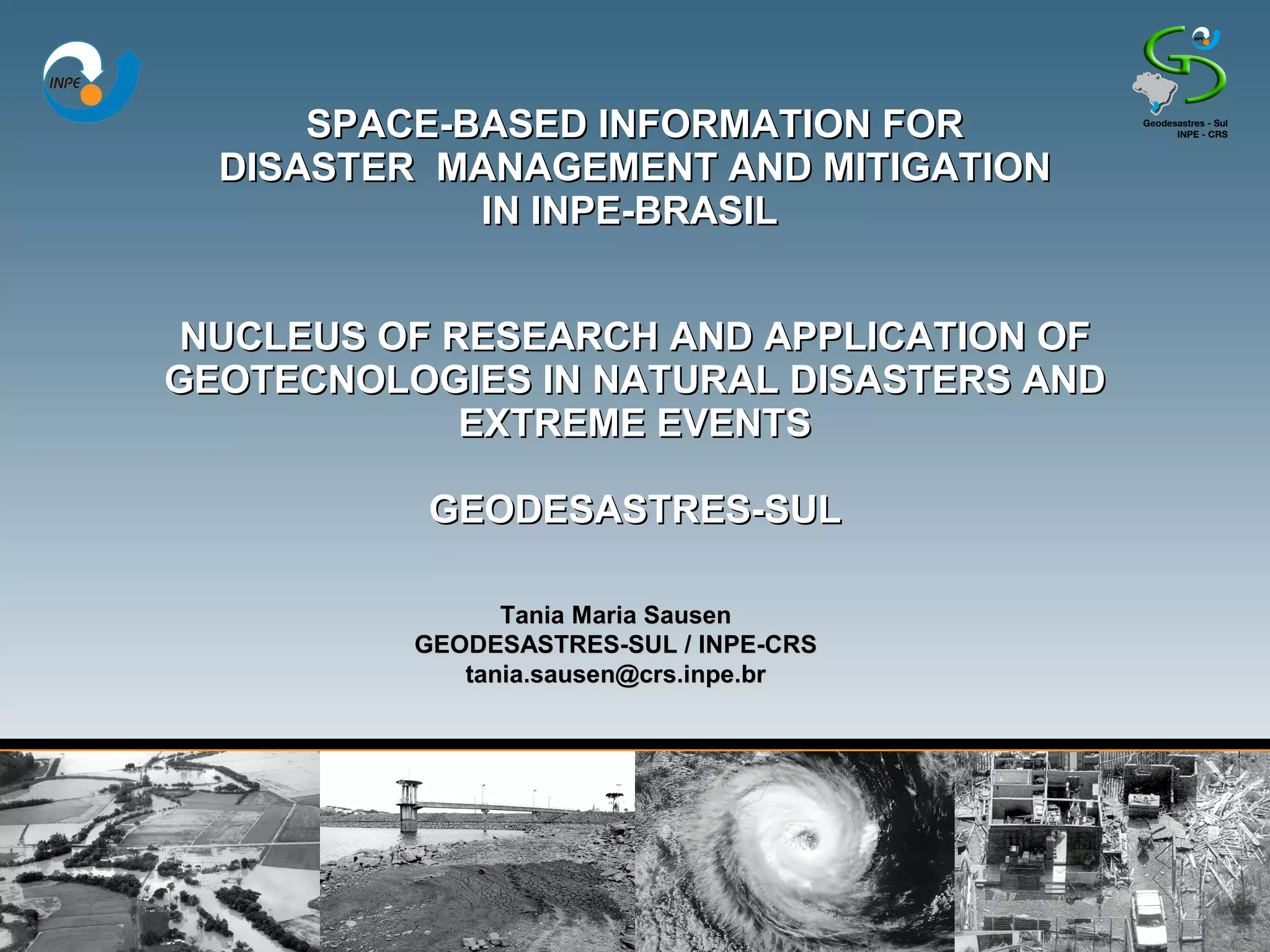
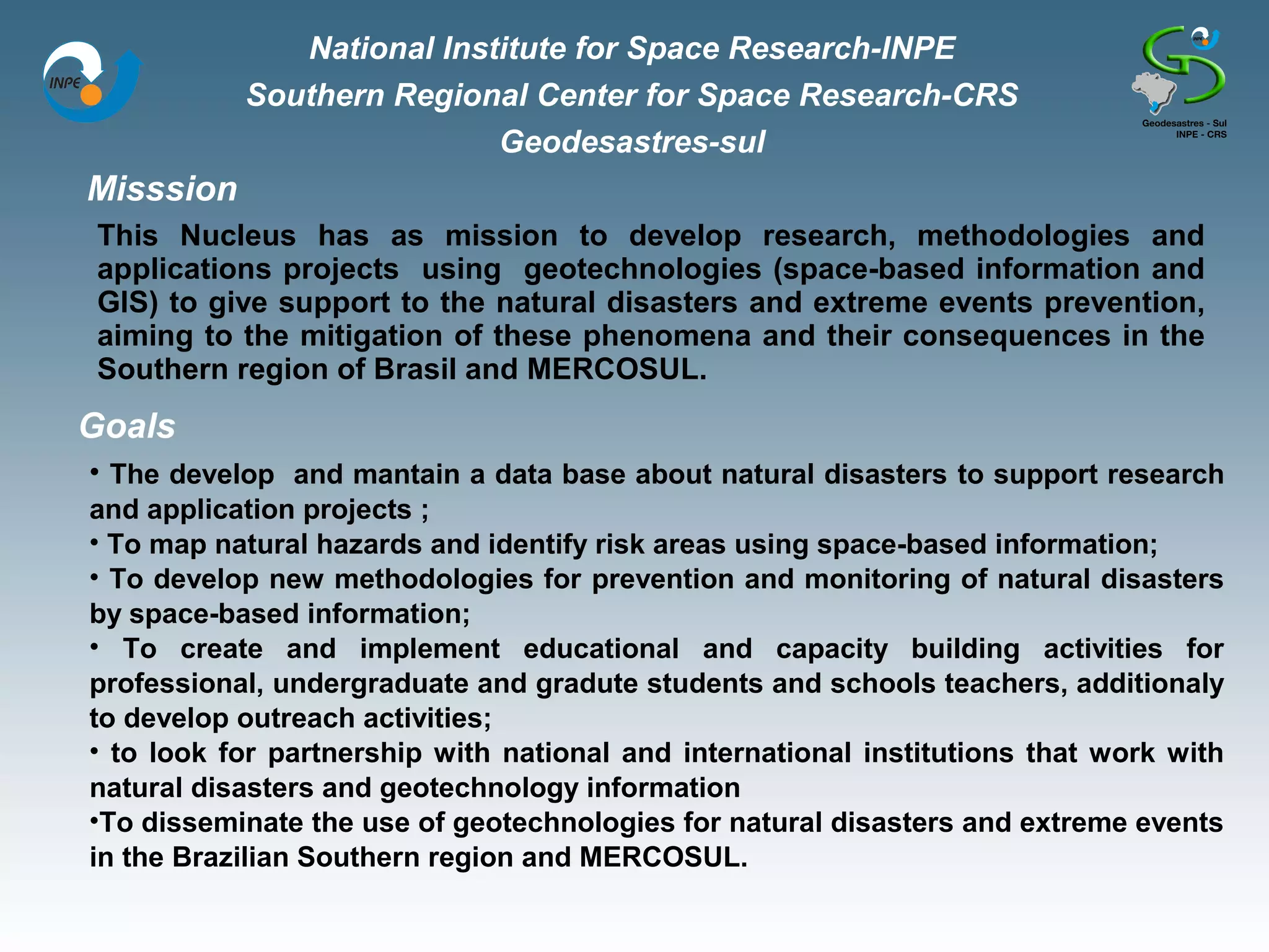
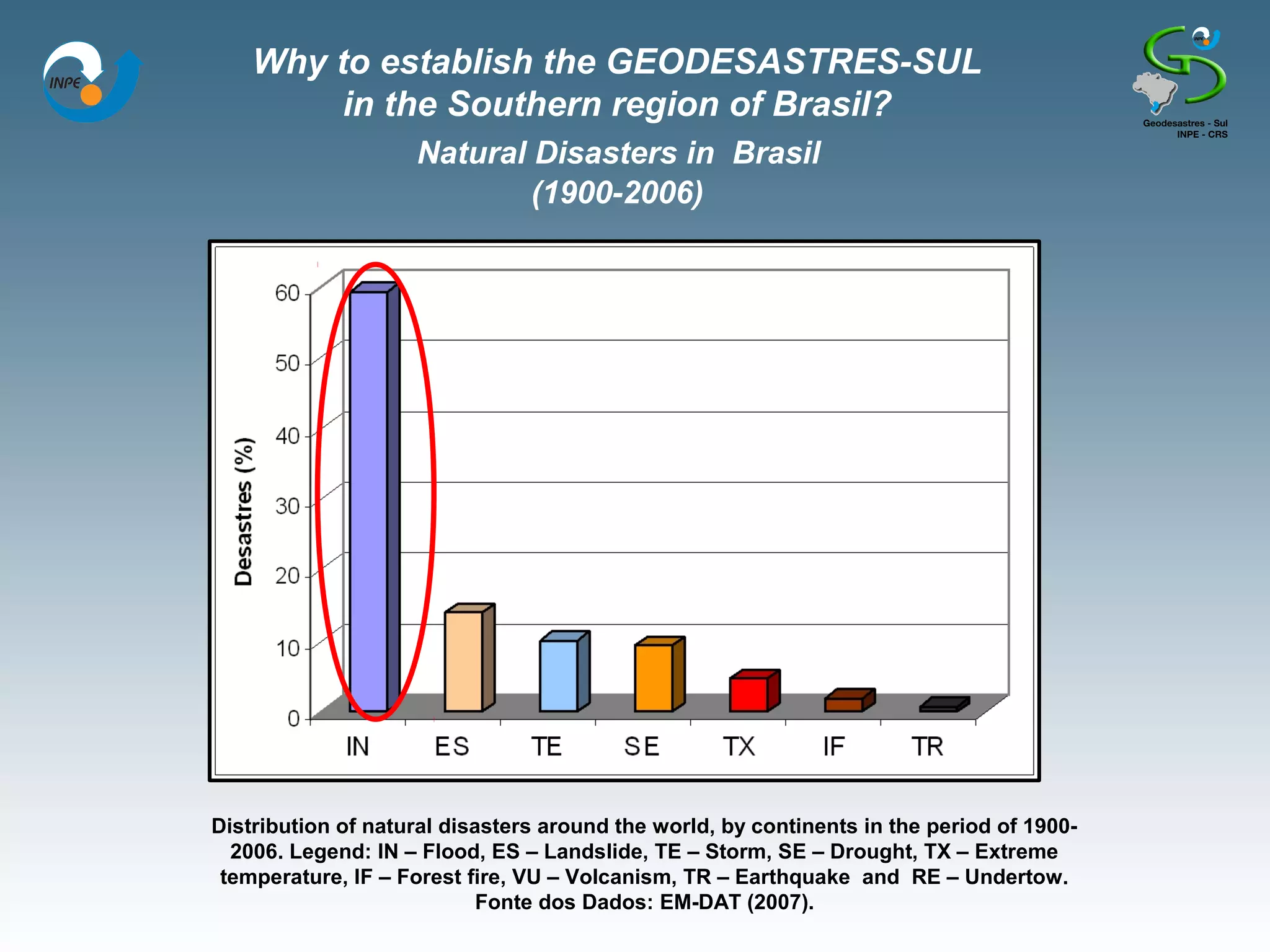
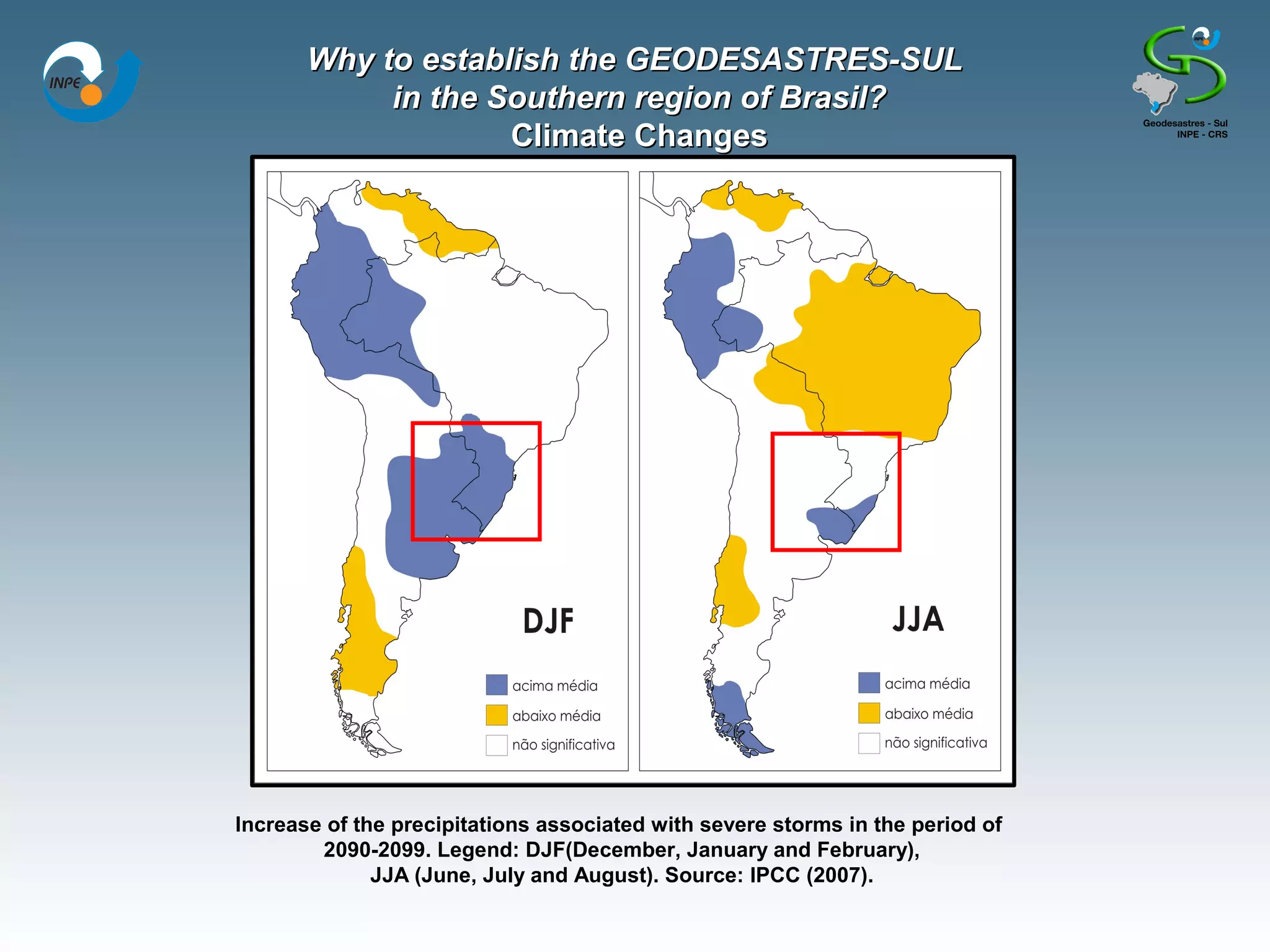
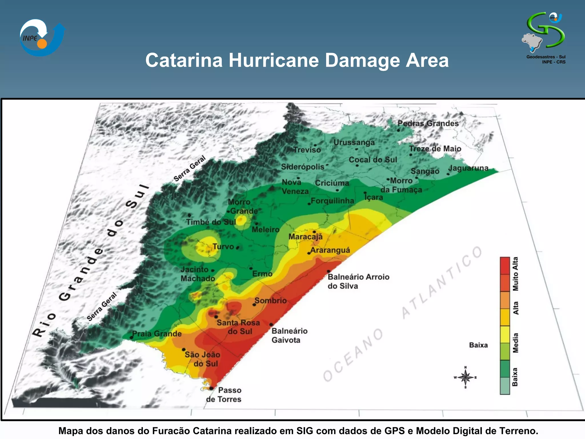
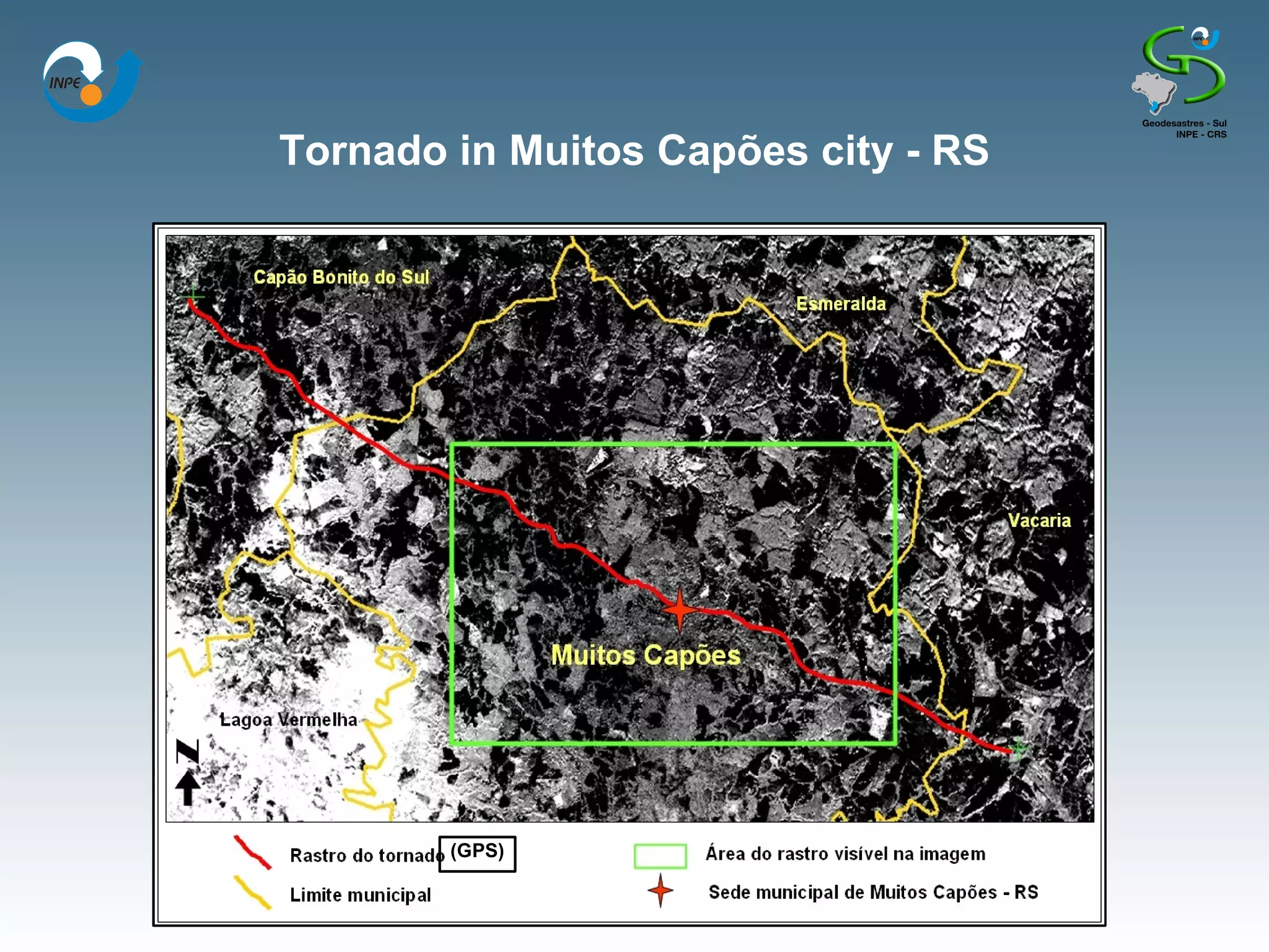
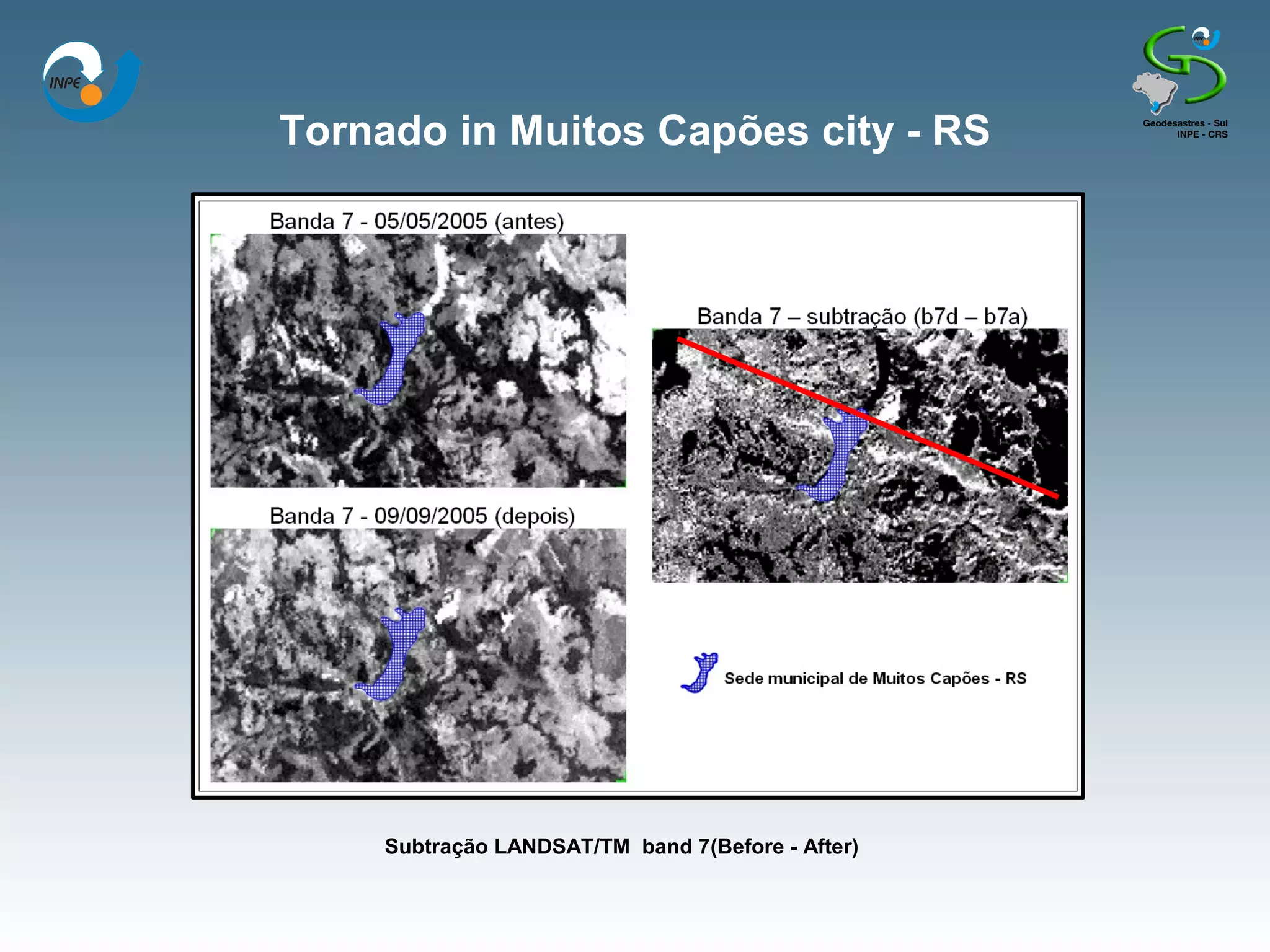
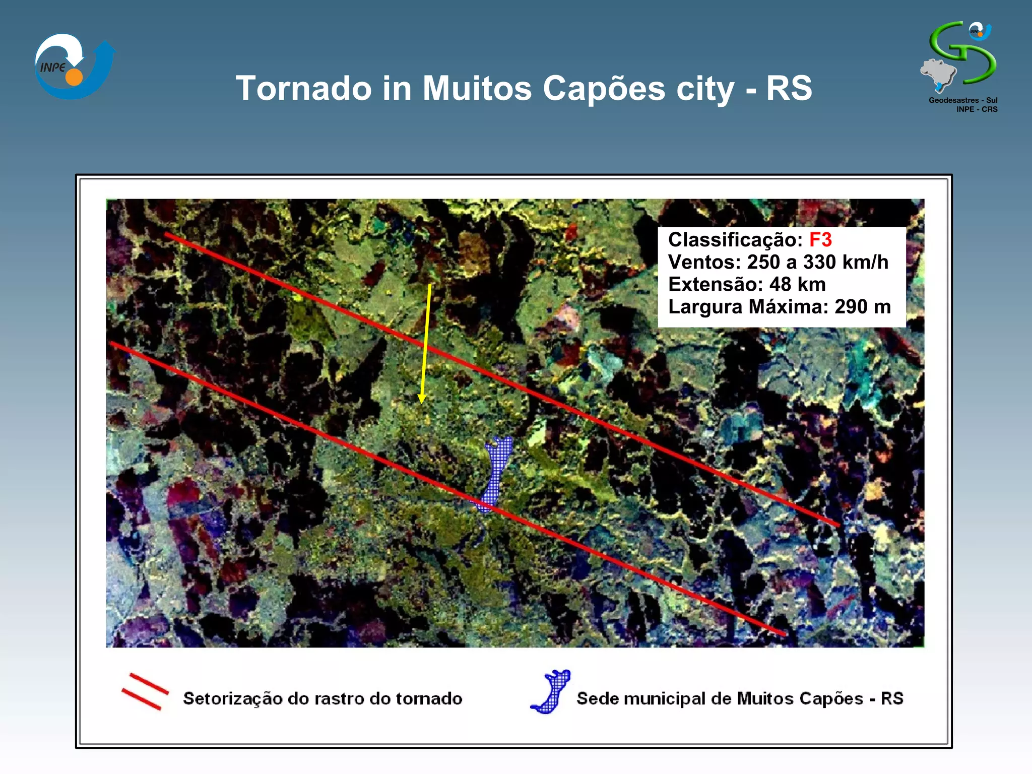
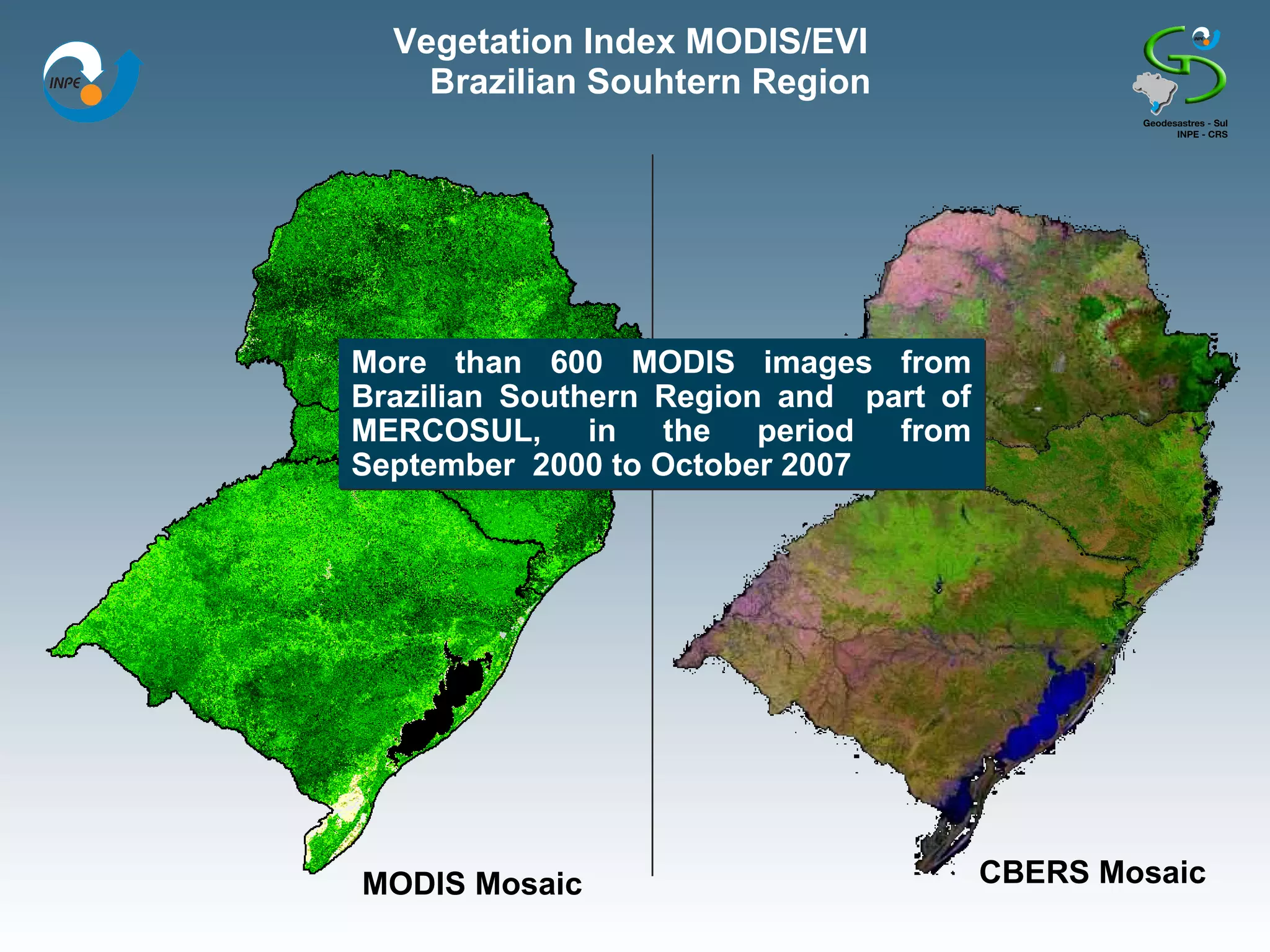
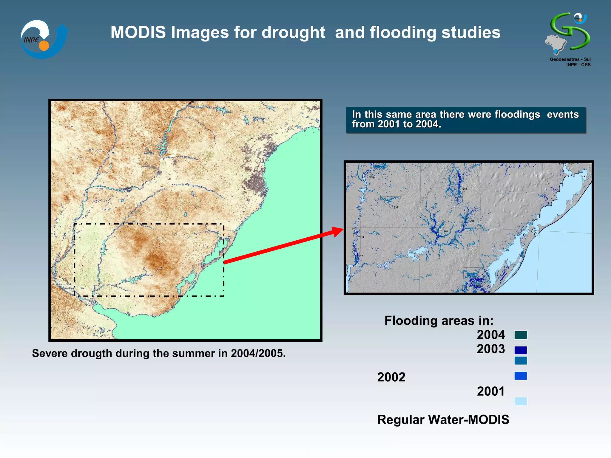
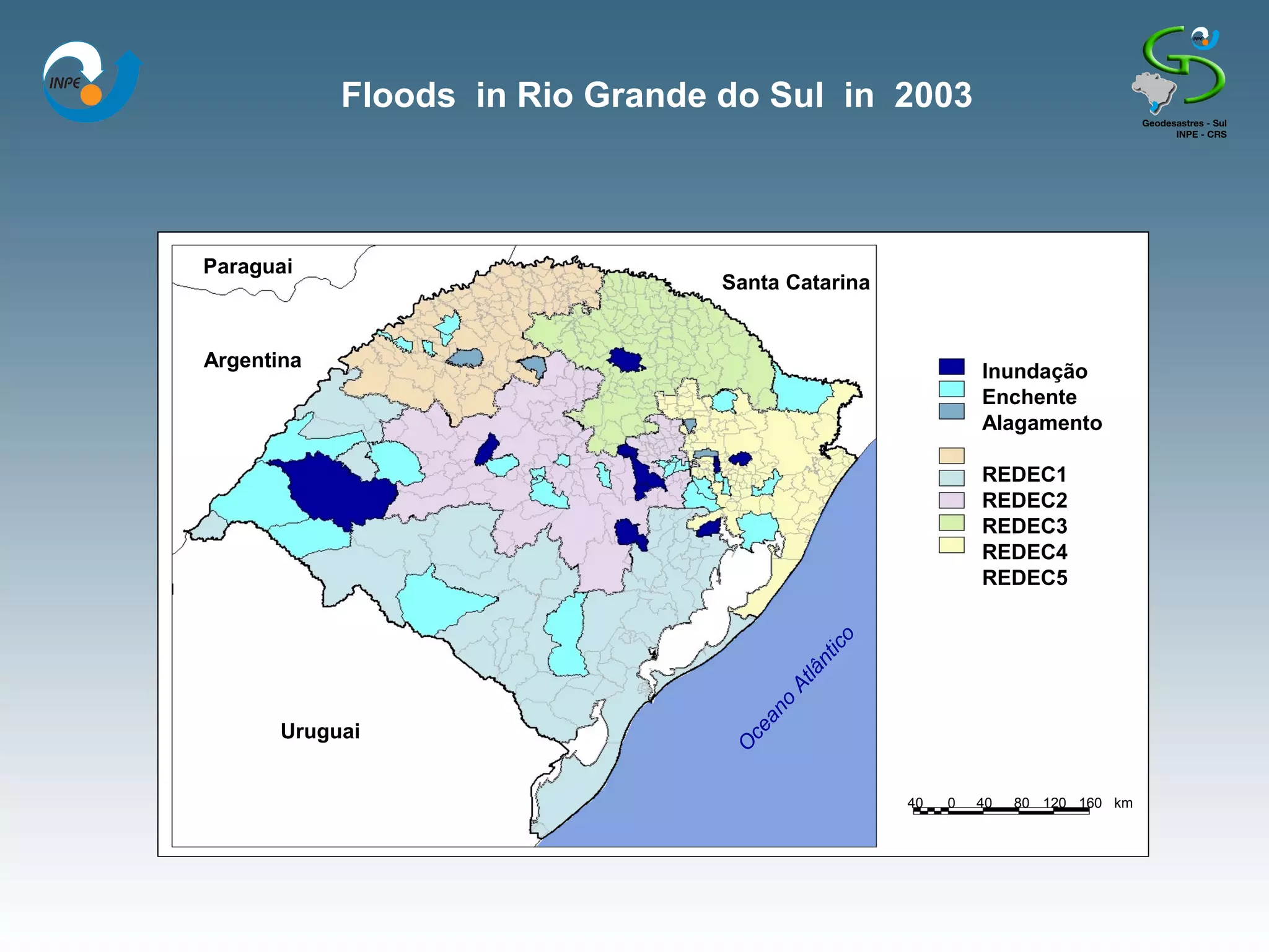
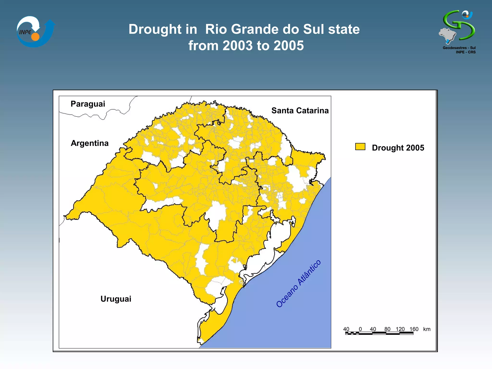
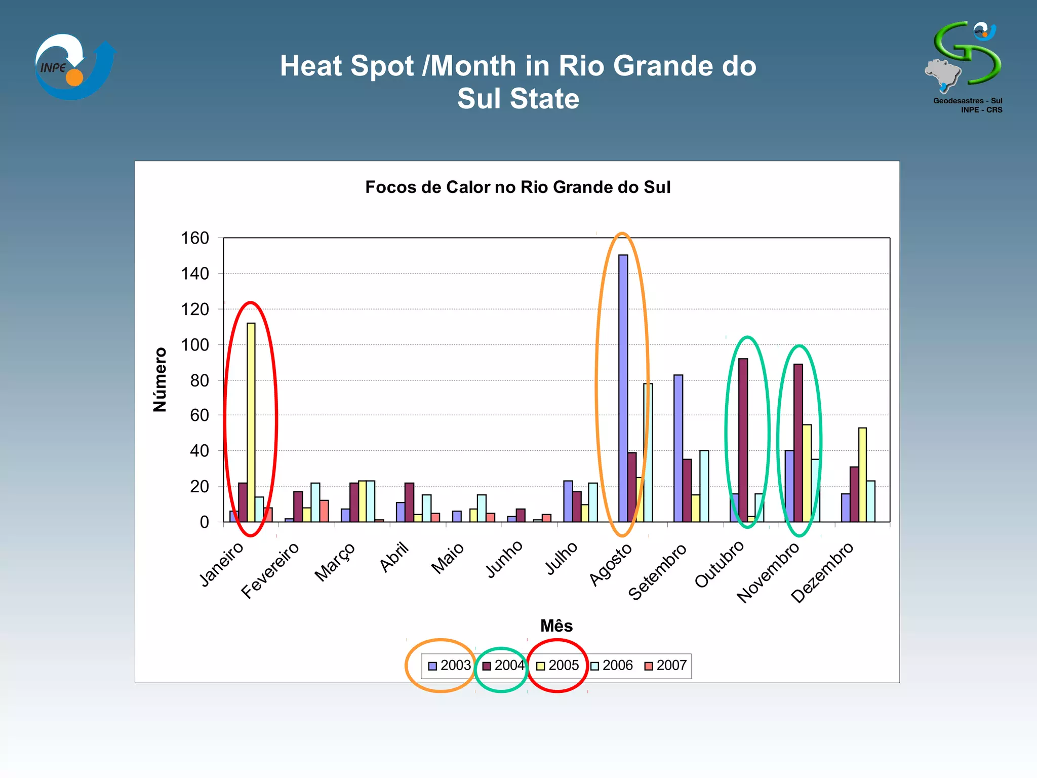
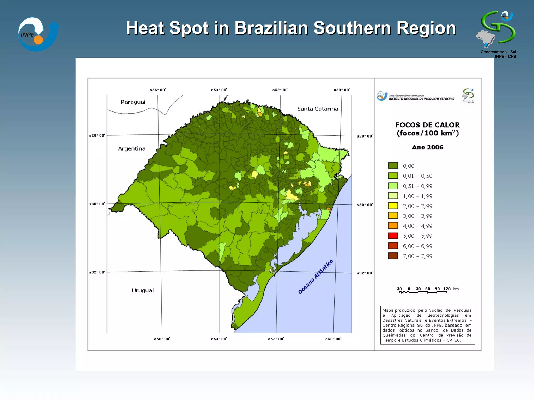
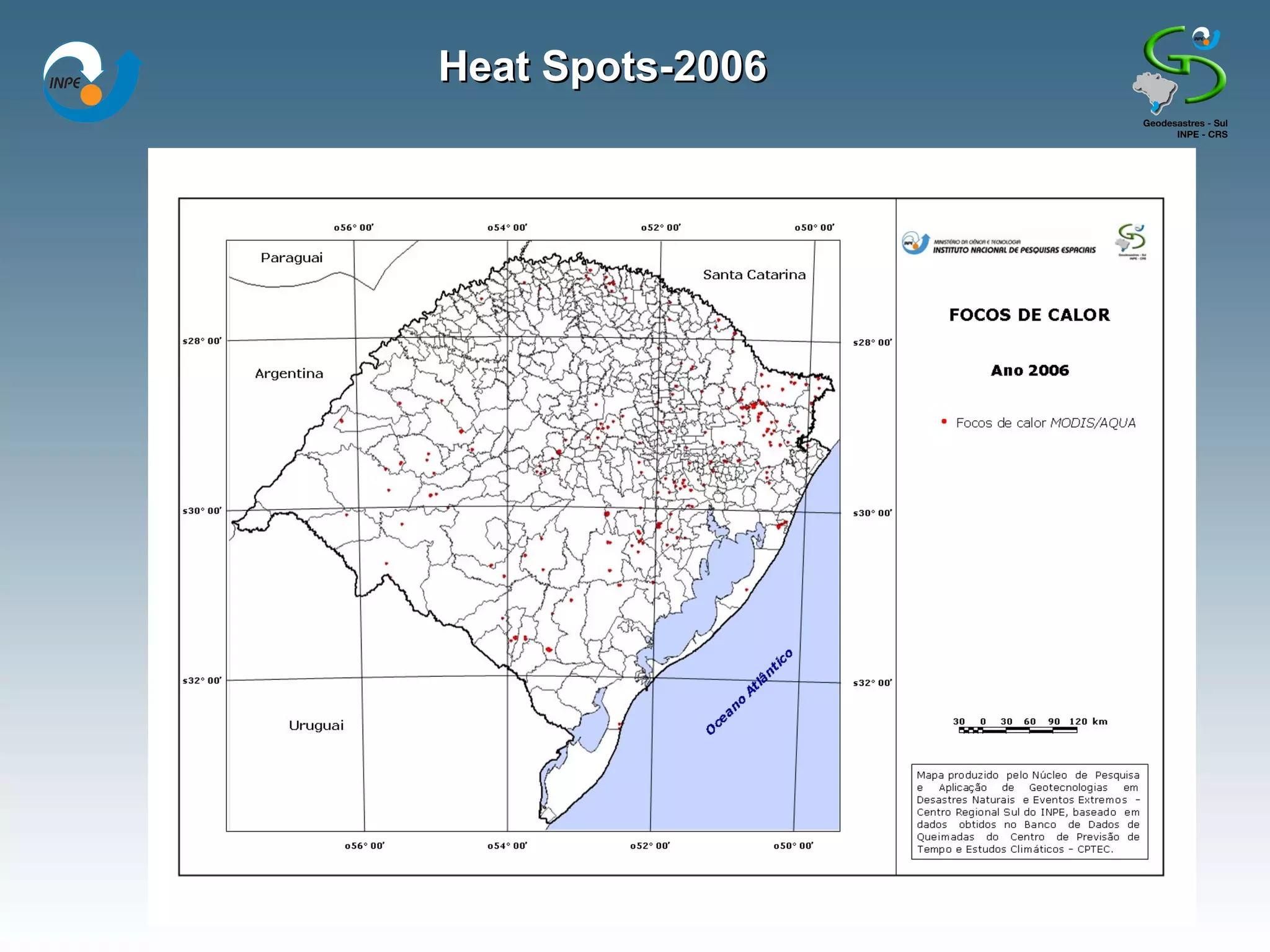
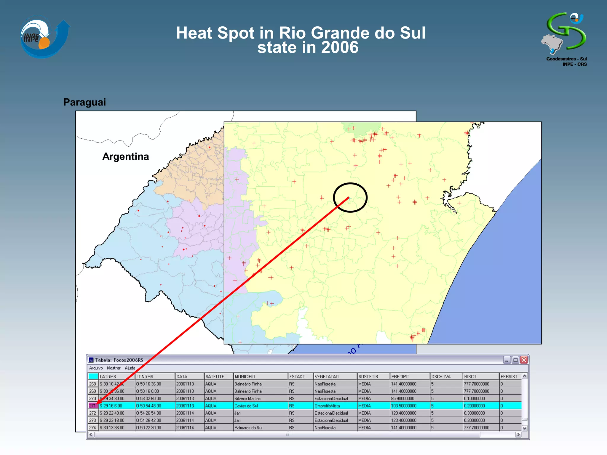
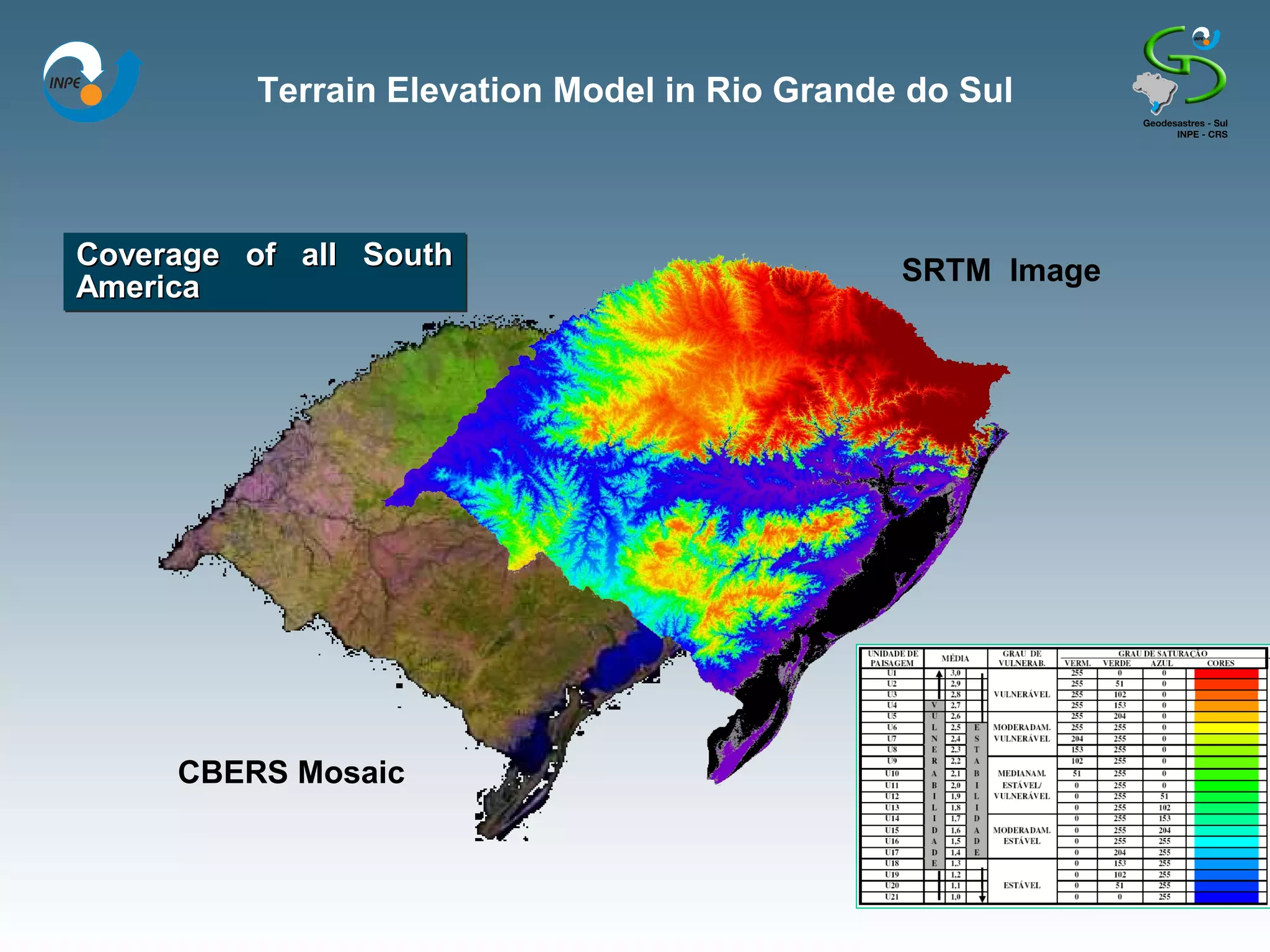
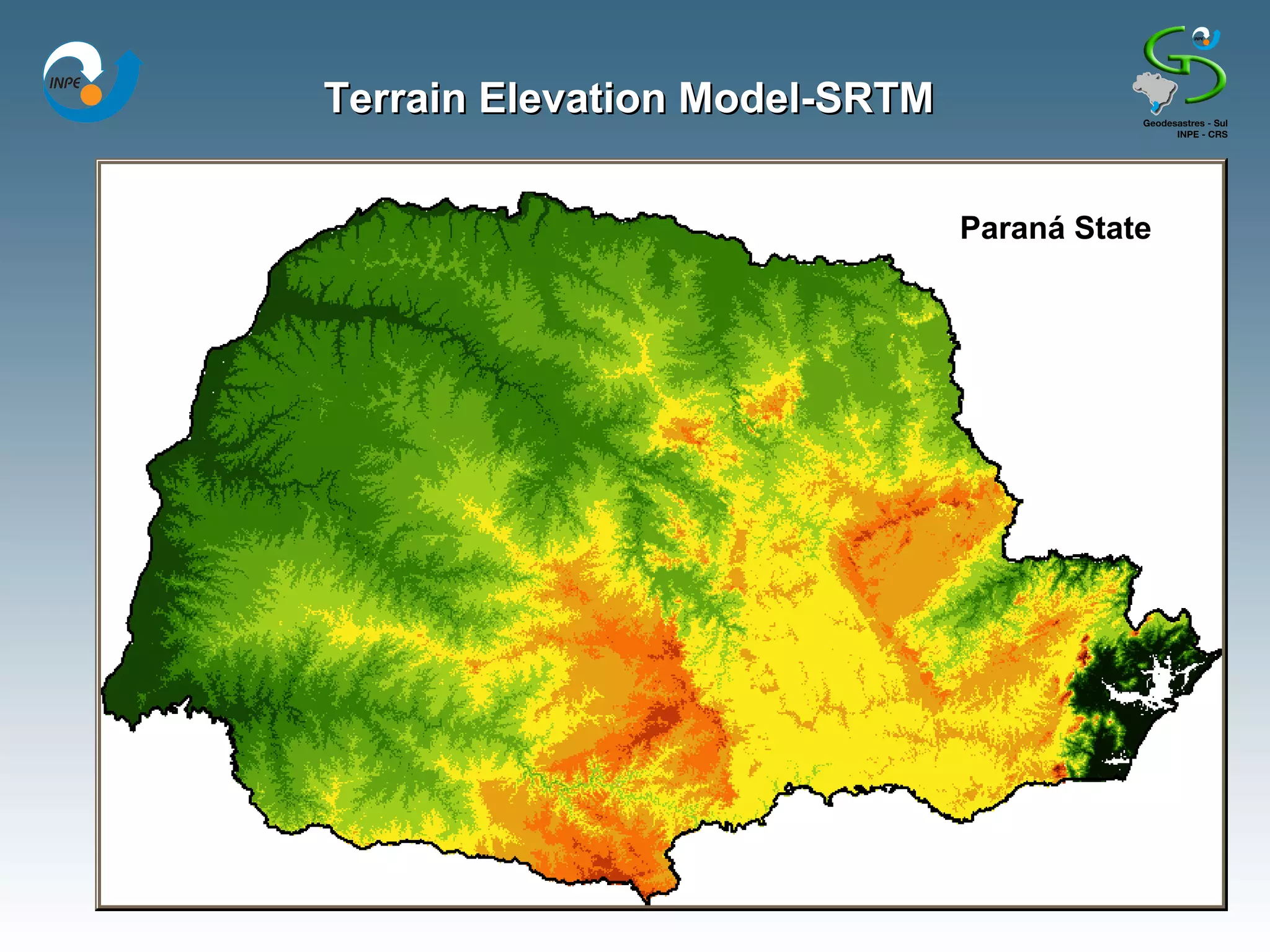
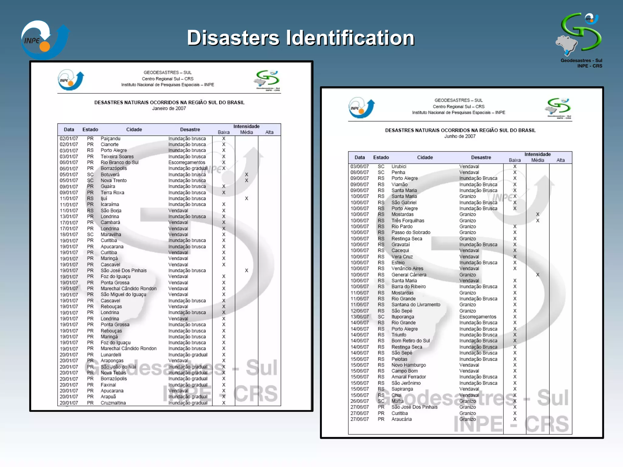
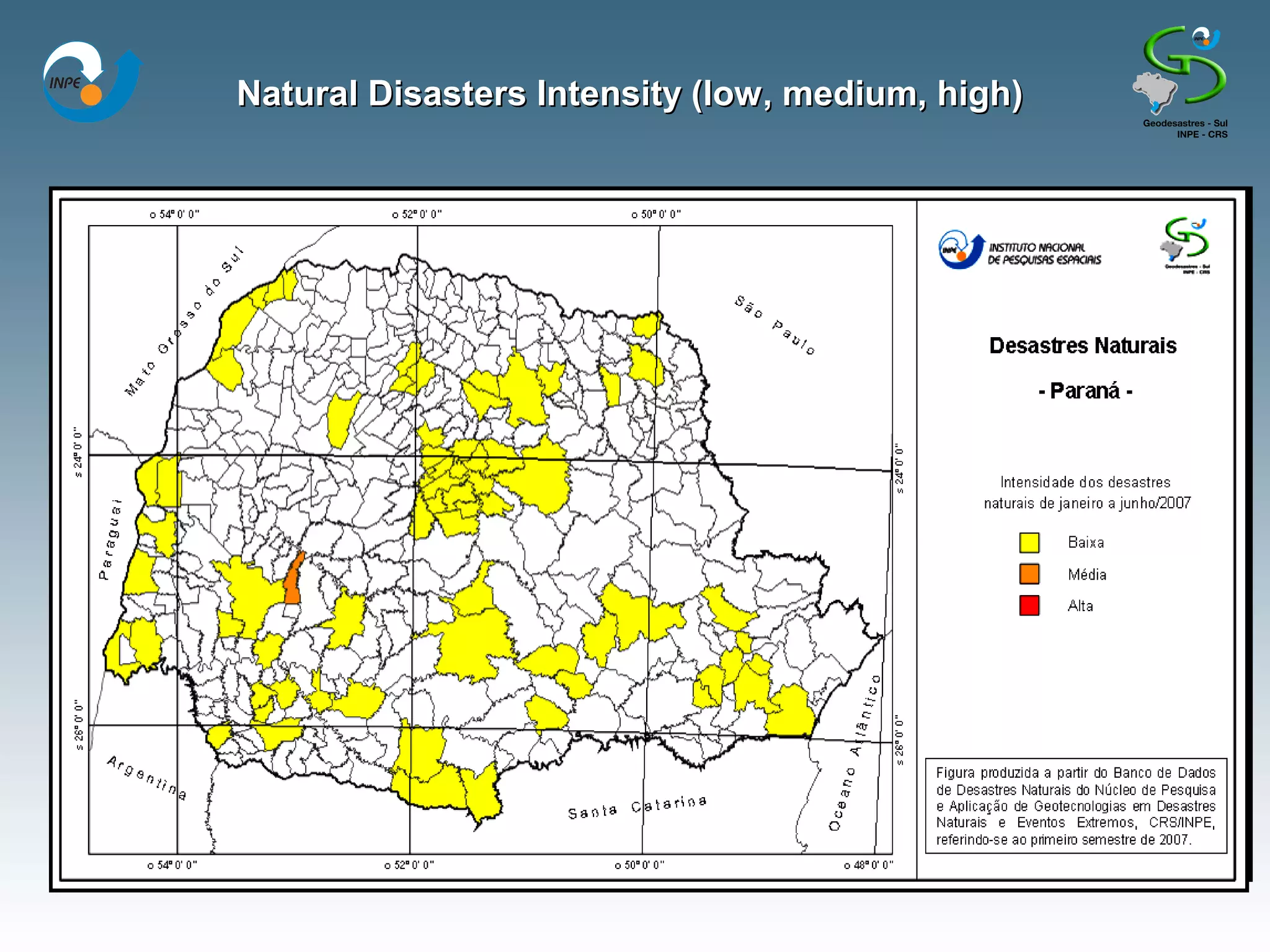
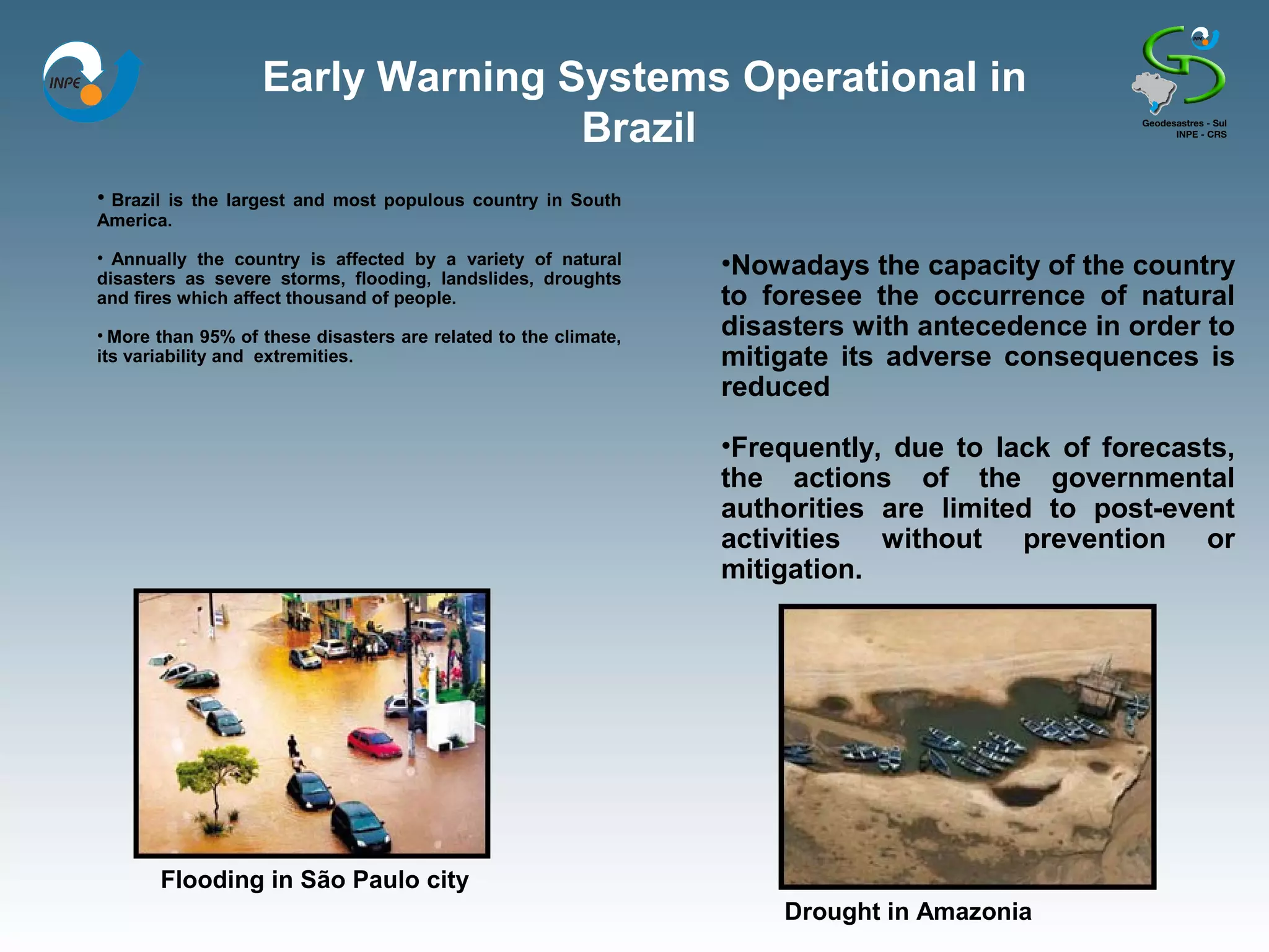
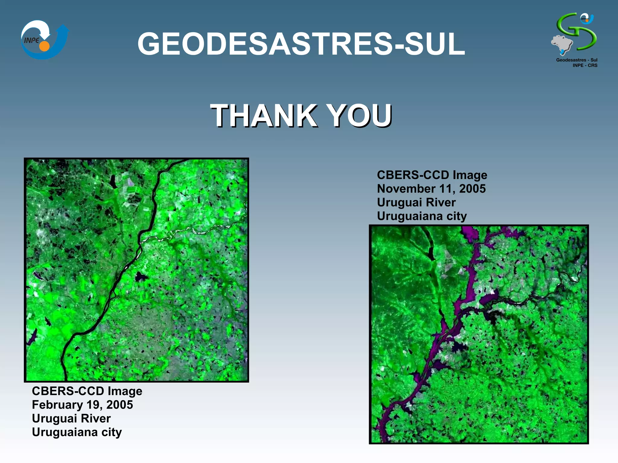
SPACE-BASED INFORMATION FOR
  DISASTER MANAGEMENT AND MITIGATION
             IN INPE-BRASIL


 NUCLEUS OF RESEARCH AND APPLICATION OF
GEOTECNOLOGIES IN NATURAL DISASTERS AND
             EXTREME EVENTS

          GEODESASTRES-SUL

                Tania Maria Sausen
          GEODESASTRES-SUL / INPE-CRS
             tania.sausen@crs.inpe.br
National Institute for Space Research-INPE
           Southern Regional Center for Space Research-CRS
                           Geodesastres-sul
Misssion
 This Nucleus has as mission to develop research, methodologies and
 applications projects using geotechnologies (space-based information and
 GIS) to give support to the natural disasters and extreme events prevention,
 aiming to the mitigation of these phenomena and their consequences in the
 Southern region of Brasil and MERCOSUL.
Goals
• The develop and mantain a data base about natural disasters to support research
and application projects ;
• To map natural hazards and identify risk areas using space-based information;
• To develop new methodologies for prevention and monitoring of natural disasters
by space-based information;
• To create and implement educational and capacity building activities for
professional, undergraduate and gradute students and schools teachers, additionaly
to develop outreach activities;
• to look for partnership with national and international institutions that work with
natural disasters and geotechnology information
•To disseminate the use of geotechnologies for natural disasters and extreme events
in the Brazilian Southern region and MERCOSUL.
National Institute for Space Research-INPE
       Southern Regional Center for Space Research-CRS

Facilities


INPE-CRS/Santa Maria, RS


                                           GEODESASTRES-SUL facilities
National Institute for Space Research-INPE
        Southern Regional Center for Space Research-CRS

Facilities
Why to establish the GEODESASTRES-SUL
         in the Southern region of Brasil?
                 Natural Disasters in the World
                          (1900-2006)


Distribution of natural disasters around the world, by continents in the period of 1900-
  2006. Legend: IN – Flood, ES – Landslide, TE – Storm, SE – Drought, TX – Extreme
 temperature, IF – Forest fire, VU – Volcanism, TR – Earthquake and RE – Undertow.
                            Fonte dos Dados: EM-DAT (2007).
Why to establish the GEODESASTRES-SUL
         in the Southern region of Brasil?
                    Natural Disasters in Brasil
                            (1900-2006)


Distribution of natural disasters around the world, by continents in the period of 1900-
  2006. Legend: IN – Flood, ES – Landslide, TE – Storm, SE – Drought, TX – Extreme
 temperature, IF – Forest fire, VU – Volcanism, TR – Earthquake and RE – Undertow.
                            Fonte dos Dados: EM-DAT (2007).
Why to establish the GEODESASTRES-SUL
            in the Southern region of Brasil?
                    Climate Changes


Increase of the precipitations associated with severe storms in the period of
        2090-2099. Legend: DJF(December, January and February),
              JJA (June, July and August). Source: IPCC (2007).
Climate Changes
More Catarinas?!
Natural Disasters-Geotechnologies
GEODESASTRES-SUL
    Data Base
a) Data Input:
      • Data about natural disasters and extreme events given by the
      Damage Evaluation Report from the Civil Defense (AVADAN) and from
      the newspapers, magazines, etc;
      • Geoenvironmental data from satellite images, meteorological data,
      cartographic data and model data;
      • Socio-economical data, such as: population, poverty index; health
      conditions, education, etc.;
      • Field work data, such as: questionary, damage and prejuizos
      evaluation, etc.
b) Process:
      • Natural disasters Inventary and sitematization;
      • Development of danger, vulnerability and risk maps;
      • Diagnosys about the risk areas;
      • Monitoring of disasters and extreme events(before and during the
      disasters);
      • Geoenvironmental diagnoses of disasters and extreme events (after
      the disasters).
c) Users Interface
DATA BASE
HOMEPAGE
HOMEPAGE
HOMEPAGE
HOMEPAGE
HOMEPAGE
DATABASE AND HOMEPAGE


Up to 1800 publications collected

Every day 33 news papers from South region in Brazil are
accessed

   More than 100 disasters were reported since January
   in the three states from South region and more than
   500 municipalities were damages by theses events;

Precipitation data were collected in 1500 estações in the
three southerns states. From these data precipitation
historical series were developed.

More than 10.000 natural disasters events information
were collected since 1980.
Catarina Hurricane


23/03/04                               24/03/04              26/03/04
10:09 (Vis)                            10:39 (Vis)           11:39 (Vis)


27/03/04                               27/03/04              28/03/04
10:09 (Vis)                            20:39 (IR)            03:39 (IR)


Catarina Hurricane monitoring by GOES 12 satellite images.
Catarina Hurricane


MODIS image from Catarina Hurricane, on 27/march/2004.
             Image source: NASA (2007)
Catarina Hurricane Damage Area


Mapa dos danos do Furacão Catarina realizado em SIG com dados de GPS e Modelo Digital de Terreno.
Tornado in Muitos Capões city - RS


        (GPS)
Tornado in Muitos Capões city - RS


     Subtração LANDSAT/TM band 7(Before - After)
Tornado in Muitos Capões city - RS


                         Classificação: F3
                         Ventos: 250 a 330 km/h
                         Extensão: 48 km
                         Largura Máxima: 290 m
Vegetation Index MODIS/EVI
    Brazilian Souhtern Region


More than 600 MODIS images from
Brazilian Southern Region and part of
MERCOSUL, in the period from
September 2000 to October 2007


MODIS Mosaic                            CBERS Mosaic
MODIS Images for drought and flooding studies


                                                 In this same area there were floodings events
                                                 In this same area there were floodings events
                                                 from 2001 to 2004.
                                                 from 2001 to 2004.


                                                       Flooding areas in:
                                                                      2004
Severe drougth during the summer in 2004/2005.                        2003

                                                     2002
                                                                         2001

                                                     Regular Water-MODIS
Flooding Monitoring

MODIS/AQUA Image-September 9th, 2007

MODIS/AQUA Image- September 25th, 2007
Floods in Rio Grande do Sul in 2003


Paraguai
                                 Santa Catarina


Argentina
                                                            Inundação
                                                            Enchente
                                                            Alagamento

                                                            REDEC1
                                                            REDEC2
                                                            REDEC3
                                                            REDEC4
                                                            REDEC5


                                             ico
                                              nt
                                            lâ
                                         At
                                    no
                                     a
       Uruguai
                                  ce
                                 O

                                                   40   0   40   80 120 160 km
Drought in Rio Grande do Sul state
                     from 2003 to 2005


Paraguai
                                Santa Catarina


Argentina
                                                               Drought 2005
                                                                       2004
                                                                       in 2003


                                                ico
                                             nt
                                          lâ
                                       At
                                        o
                                     an
      Uruguai
                                  ce
                                 O


                                                      40
                                                      40   0   40
                                                               40   80 120 160 km
                                                                    80 120 160 km
Heat Spot /Month in Rio Grande do
                                       Sul State

                                           Focos de Calor no Rio Grande do Sul

         160

         140

         120

         100
Número


          80

          60

          40

          20

           0
                                                                  o


                                                                                                ro
                                                                          o
               ir o


                                                                                                 o


                                                                                                 o
                           ir o


                                      ço


                                                       o


                                                                                 to
                                             ril


                                                                                                 o
                                                               nh


                                                                        lh


                                                                                               br


                                                                                               br
                                                    ai


                                                                                              br

                                                                                              ub
                                           Ab


                                                                               os
           ne


                        re


                                   ar


                                                                      Ju
                                                   M


                                                                                          em


                                                                                          em
                                                            Ju


                                                                                            m

                                                                                           ut
                                                                              Ag
                                  M
                      ve
         Ja


                                                                                         te

                                                                                         O


                                                                                        ov


                                                                                        ez
                 Fe


                                                                                   Se


                                                                                      N


                                                                                      D
                                                                      Mês

                                                     2003      2004    2005    2006     2007
Heat Spot in Brazilian Southern Region
Heat Spots-2006
Heat Spot in Rio Grande do Sul
                                state in 2006


Paraguai

                                       Santa Catarina

       Argentina                                          + Focos de calor 2006


                                                    ico
                                                 nt
                                                lâ
                                             At
                                             o
            Uruguai
                                          an
                                        ce
                                       O
Terrain Elevation Model in Rio Grande do Sul


Coverage of all South
         of all South                          SRTM Image
America


     CBERS Mosaic
Terrain Elevation Model-SRTM

                                         Paraná State


Santa Catarina state
    Rio Grande do Sul state
Disasters Identification
Natural Disasters Intensity (low, medium, high)
Kinds of Natural Disasters
CAPACITY BUILDING
                             Educational Material


TOPICS:
• Natural Disasters-Fundamentals Concepts;
• Geotechnologies-Fundamentals Concepts;
• Natural Disasters and Geotechnologies: Lanslides; Drought; Hurricane; Flood; Burning; Heat
Islands; Hail; Tornado; Windstorm; Earthquake; Avalanche; Lahar; Tsunami; Volcanic activity
CAPACITY BUILDING
                    Training Courses

   REGIONAL CENTER FOR SPACE SCIENCE AND TECHNOLOGY
EDUCATION FOR LATINA AMERICA AND THE CARIBBEAN-CRECTEALC
                      CAMPUS BRASIL
                 (AFFILIATED TO THE UNITED NATIONS)

         NATIONAL INSTITUTE FOR PSACE RESEARCH-INPE
          Southern Regional Center for Space Research-CRS
                       GEODESASTRES-SUL

  With the support of the United Nations Office for Outer Space Affairs
(UNOOSA) by its new program UN-SPIDER – United Nations Platform for
   Space-based Information for Disaster Management and Emergency
                               Response

                          I SEMINAR
 “GEOTHECNOLOGIES FOR NATURAL DISASTERS PREVENTION AND
  MITIGATION IN THE BRAZILIAN SOUTH REGION AND MERCOSUL”
                     November 27-29, 2007
Early Warning Systems Operational in
                                  Brazil
• Brazil
       is the largest and most populous country in South
America.

• Annually the country is affected by a variety of natural
disasters as severe storms, flooding, landslides, droughts
                                                                 •Nowadays the capacity of the country
and fires which affect thousand of people.                       to foresee the occurrence of natural
• More than 95% of these disasters are related to the climate,   disasters with antecedence in order to
its variability and extremities.                                 mitigate its adverse consequences is
                                                                 reduced

                                                                 •Frequently, due to lack of forecasts,
                                                                 the actions of the governmental
                                                                 authorities are limited to post-event
                                                                 activities without prevention or
                                                                 mitigation.


           Flooding in São Paulo city
                                                                     Drought in Amazonia
CPTEC/INPE
•   The Center for Weather Forecasting and Climate Studies -CPTEC of
    INPE develops, produces and disseminates weather forecasts as well
    as seasonal climate forecasts.

•   Since its establishment in 1994, the CPTEC/INPE disseminates
    meteorological warnings of extreme meteorological phenomenon for
    the whole country.

•   In case of intense or drawn out rains, the CPTEC/INPE developed as
    part of its operational routine, an information system to support the
    Civil Defense.
Semi-automatic System of Forecast,
         Hydrometeorological and Environmental Data to
              Sustain Natural Hazards Management
CPTEC/INPE and others Brazilian institutions are developing a semi-automatic
system of forecast, hydrometeorological and environmental data to sustain
natural hazards management.

The main objective of the project is to develop predictive capacity to identify
probability of occurrence of natural disasters caused by meteorological and
climatic extremities for the 5500 Brazilian municipalities.


         Map of number of days with hydric deficit
         http://www.cptec.inpe.br/proclima/index.shtml   Potential Risk Map
                                                         http://sigma.cptec.inpe.br/produto/queimadas
Semi-automatic System of Forecast, Hydrometeorological and
                              Environmental Data
                    to Sustain Natural Hazards Management


                                   Natural hazards risk
                                   and vulnerability data


                                     Potential risk areas
                                          mapping


Meteorological,                      Semi-automatic System                           U
    climate        Environmental           of Forecast,                              S
and hydrological     extremes         Hydrometeorological       ANALISIS   WARNING   E
                                                                                         ACTIONS
      data                              and Environmental                            R
                                         Data to Sustain
                                                                                     S
                                   Natural Hazards Management


                                   Additional databases
Semi-automatic System of Forecast, Hydrometeorological and
                            Environmental Data
                  to Sustain Natural Hazards Management


                                                                 Pilot Project


DR. EYMAR SILVA SAMPAIO LOPES         http://www.cptec.inpe.br/serradomar/desenvolvimento.shtml
Coordinadtor-INPE/
                 DPI
Landslide in São Sebastião in 06 December 1994


                                                                   Photo IPT (2001)


After the
Before the
Landslide


Pedras River Basin
+ than 100 spots of mass movement
                                                   Presidente Bernardes Refinery
BRAZILIAN DISASTERS NETWORK
                        AND PORTAL
                   IBGE SEMINAR IN AUGUST 30TH, 2007

The Brazilian Institute for Geography and Statistic-IBGE has invited all
Brazilian institutions involved wiht disasters to build up a network and a
portal about disasters activities in Brasil. The goals of this portal are:

•To put together all information about disasters that are available in several differents
sites

•To give more accessibility about disaster information to the Brazilian community;

•To ensure that relevant information is easily accessible and disseminated to all
interested end-users

•To be a bridge to connect the disaster management and space communities

•To transfer of knowledge and technology to Brazilian community

• To establish communities of practice

• To be a platform for fostering alliances
GEODESASTRES-SUL

                    THANK YOU
                            CBERS-CCD Image
                            November 11, 2005
                            Uruguai River
                            Uruguaiana city


CBERS-CCD Image
February 19, 2005
Uruguai River
Uruguaiana city

SPACE-BASED INFORMATION FOR DISASTER MANAGEMENT AND MITIGATION IN INPE-BRASIL

  • 1.
    SPACE-BASED INFORMATION FOR DISASTER MANAGEMENT AND MITIGATION IN INPE-BRASIL NUCLEUS OF RESEARCH AND APPLICATION OF GEOTECNOLOGIES IN NATURAL DISASTERS AND EXTREME EVENTS GEODESASTRES-SUL Tania Maria Sausen GEODESASTRES-SUL / INPE-CRS tania.sausen@crs.inpe.br
  • 2.
    National Institute forSpace Research-INPE Southern Regional Center for Space Research-CRS Geodesastres-sul Misssion This Nucleus has as mission to develop research, methodologies and applications projects using geotechnologies (space-based information and GIS) to give support to the natural disasters and extreme events prevention, aiming to the mitigation of these phenomena and their consequences in the Southern region of Brasil and MERCOSUL. Goals • The develop and mantain a data base about natural disasters to support research and application projects ; • To map natural hazards and identify risk areas using space-based information; • To develop new methodologies for prevention and monitoring of natural disasters by space-based information; • To create and implement educational and capacity building activities for professional, undergraduate and gradute students and schools teachers, additionaly to develop outreach activities; • to look for partnership with national and international institutions that work with natural disasters and geotechnology information •To disseminate the use of geotechnologies for natural disasters and extreme events in the Brazilian Southern region and MERCOSUL.
  • 3.
    National Institute forSpace Research-INPE Southern Regional Center for Space Research-CRS Facilities INPE-CRS/Santa Maria, RS GEODESASTRES-SUL facilities
  • 4.
    National Institute forSpace Research-INPE Southern Regional Center for Space Research-CRS Facilities
  • 5.
    Why to establishthe GEODESASTRES-SUL in the Southern region of Brasil? Natural Disasters in the World (1900-2006) Distribution of natural disasters around the world, by continents in the period of 1900- 2006. Legend: IN – Flood, ES – Landslide, TE – Storm, SE – Drought, TX – Extreme temperature, IF – Forest fire, VU – Volcanism, TR – Earthquake and RE – Undertow. Fonte dos Dados: EM-DAT (2007).
  • 6.
    Why to establishthe GEODESASTRES-SUL in the Southern region of Brasil? Natural Disasters in Brasil (1900-2006) Distribution of natural disasters around the world, by continents in the period of 1900- 2006. Legend: IN – Flood, ES – Landslide, TE – Storm, SE – Drought, TX – Extreme temperature, IF – Forest fire, VU – Volcanism, TR – Earthquake and RE – Undertow. Fonte dos Dados: EM-DAT (2007).
  • 7.
    Why to establishthe GEODESASTRES-SUL in the Southern region of Brasil? Climate Changes Increase of the precipitations associated with severe storms in the period of 2090-2099. Legend: DJF(December, January and February), JJA (June, July and August). Source: IPCC (2007).
  • 8.
  • 9.
  • 10.
    GEODESASTRES-SUL Data Base a) Data Input: • Data about natural disasters and extreme events given by the Damage Evaluation Report from the Civil Defense (AVADAN) and from the newspapers, magazines, etc; • Geoenvironmental data from satellite images, meteorological data, cartographic data and model data; • Socio-economical data, such as: population, poverty index; health conditions, education, etc.; • Field work data, such as: questionary, damage and prejuizos evaluation, etc. b) Process: • Natural disasters Inventary and sitematization; • Development of danger, vulnerability and risk maps; • Diagnosys about the risk areas; • Monitoring of disasters and extreme events(before and during the disasters); • Geoenvironmental diagnoses of disasters and extreme events (after the disasters). c) Users Interface
  • 11.
  • 12.
  • 13.
  • 14.
  • 15.
  • 16.
  • 17.
    DATABASE AND HOMEPAGE Upto 1800 publications collected Every day 33 news papers from South region in Brazil are accessed More than 100 disasters were reported since January in the three states from South region and more than 500 municipalities were damages by theses events; Precipitation data were collected in 1500 estações in the three southerns states. From these data precipitation historical series were developed. More than 10.000 natural disasters events information were collected since 1980.
  • 18.
    Catarina Hurricane 23/03/04 24/03/04 26/03/04 10:09 (Vis) 10:39 (Vis) 11:39 (Vis) 27/03/04 27/03/04 28/03/04 10:09 (Vis) 20:39 (IR) 03:39 (IR) Catarina Hurricane monitoring by GOES 12 satellite images.
  • 19.
    Catarina Hurricane MODIS imagefrom Catarina Hurricane, on 27/march/2004. Image source: NASA (2007)
  • 20.
    Catarina Hurricane DamageArea Mapa dos danos do Furacão Catarina realizado em SIG com dados de GPS e Modelo Digital de Terreno.
  • 21.
    Tornado in MuitosCapões city - RS (GPS)
  • 22.
    Tornado in MuitosCapões city - RS Subtração LANDSAT/TM band 7(Before - After)
  • 23.
    Tornado in MuitosCapões city - RS Classificação: F3 Ventos: 250 a 330 km/h Extensão: 48 km Largura Máxima: 290 m
  • 24.
    Vegetation Index MODIS/EVI Brazilian Souhtern Region More than 600 MODIS images from Brazilian Southern Region and part of MERCOSUL, in the period from September 2000 to October 2007 MODIS Mosaic CBERS Mosaic
  • 25.
    MODIS Images fordrought and flooding studies In this same area there were floodings events In this same area there were floodings events from 2001 to 2004. from 2001 to 2004. Flooding areas in: 2004 Severe drougth during the summer in 2004/2005. 2003 2002 2001 Regular Water-MODIS
  • 26.
    Flooding Monitoring MODIS/AQUA Image-September9th, 2007 MODIS/AQUA Image- September 25th, 2007
  • 27.
    Floods in RioGrande do Sul in 2003 Paraguai Santa Catarina Argentina Inundação Enchente Alagamento REDEC1 REDEC2 REDEC3 REDEC4 REDEC5 ico nt lâ At no a Uruguai ce O 40 0 40 80 120 160 km
  • 28.
    Drought in RioGrande do Sul state from 2003 to 2005 Paraguai Santa Catarina Argentina Drought 2005 2004 in 2003 ico nt lâ At o an Uruguai ce O 40 40 0 40 40 80 120 160 km 80 120 160 km
  • 29.
    Heat Spot /Monthin Rio Grande do Sul State Focos de Calor no Rio Grande do Sul 160 140 120 100 Número 80 60 40 20 0 o ro o ir o o o ir o ço o to ril o nh lh br br ai br ub Ab os ne re ar Ju M em em Ju m ut Ag M ve Ja te O ov ez Fe Se N D Mês 2003 2004 2005 2006 2007
  • 30.
    Heat Spot inBrazilian Southern Region
  • 31.
  • 32.
    Heat Spot inRio Grande do Sul state in 2006 Paraguai Santa Catarina Argentina + Focos de calor 2006 ico nt lâ At o Uruguai an ce O
  • 33.
    Terrain Elevation Modelin Rio Grande do Sul Coverage of all South of all South SRTM Image America CBERS Mosaic
  • 34.
    Terrain Elevation Model-SRTM Paraná State Santa Catarina state Rio Grande do Sul state
  • 35.
  • 36.
    Natural Disasters Intensity(low, medium, high)
  • 37.
  • 38.
    CAPACITY BUILDING Educational Material TOPICS: • Natural Disasters-Fundamentals Concepts; • Geotechnologies-Fundamentals Concepts; • Natural Disasters and Geotechnologies: Lanslides; Drought; Hurricane; Flood; Burning; Heat Islands; Hail; Tornado; Windstorm; Earthquake; Avalanche; Lahar; Tsunami; Volcanic activity
  • 39.
    CAPACITY BUILDING Training Courses REGIONAL CENTER FOR SPACE SCIENCE AND TECHNOLOGY EDUCATION FOR LATINA AMERICA AND THE CARIBBEAN-CRECTEALC CAMPUS BRASIL (AFFILIATED TO THE UNITED NATIONS) NATIONAL INSTITUTE FOR PSACE RESEARCH-INPE Southern Regional Center for Space Research-CRS GEODESASTRES-SUL With the support of the United Nations Office for Outer Space Affairs (UNOOSA) by its new program UN-SPIDER – United Nations Platform for Space-based Information for Disaster Management and Emergency Response I SEMINAR “GEOTHECNOLOGIES FOR NATURAL DISASTERS PREVENTION AND MITIGATION IN THE BRAZILIAN SOUTH REGION AND MERCOSUL” November 27-29, 2007
  • 40.
    Early Warning SystemsOperational in Brazil • Brazil is the largest and most populous country in South America. • Annually the country is affected by a variety of natural disasters as severe storms, flooding, landslides, droughts •Nowadays the capacity of the country and fires which affect thousand of people. to foresee the occurrence of natural • More than 95% of these disasters are related to the climate, disasters with antecedence in order to its variability and extremities. mitigate its adverse consequences is reduced •Frequently, due to lack of forecasts, the actions of the governmental authorities are limited to post-event activities without prevention or mitigation. Flooding in São Paulo city Drought in Amazonia
  • 41.
    CPTEC/INPE • The Center for Weather Forecasting and Climate Studies -CPTEC of INPE develops, produces and disseminates weather forecasts as well as seasonal climate forecasts. • Since its establishment in 1994, the CPTEC/INPE disseminates meteorological warnings of extreme meteorological phenomenon for the whole country. • In case of intense or drawn out rains, the CPTEC/INPE developed as part of its operational routine, an information system to support the Civil Defense.
  • 42.
    Semi-automatic System ofForecast, Hydrometeorological and Environmental Data to Sustain Natural Hazards Management CPTEC/INPE and others Brazilian institutions are developing a semi-automatic system of forecast, hydrometeorological and environmental data to sustain natural hazards management. The main objective of the project is to develop predictive capacity to identify probability of occurrence of natural disasters caused by meteorological and climatic extremities for the 5500 Brazilian municipalities. Map of number of days with hydric deficit http://www.cptec.inpe.br/proclima/index.shtml Potential Risk Map http://sigma.cptec.inpe.br/produto/queimadas
  • 43.
    Semi-automatic System ofForecast, Hydrometeorological and Environmental Data to Sustain Natural Hazards Management Natural hazards risk and vulnerability data Potential risk areas mapping Meteorological, Semi-automatic System U climate Environmental of Forecast, S and hydrological extremes Hydrometeorological ANALISIS WARNING E ACTIONS data and Environmental R Data to Sustain S Natural Hazards Management Additional databases
  • 44.
    Semi-automatic System ofForecast, Hydrometeorological and Environmental Data to Sustain Natural Hazards Management Pilot Project DR. EYMAR SILVA SAMPAIO LOPES http://www.cptec.inpe.br/serradomar/desenvolvimento.shtml Coordinadtor-INPE/ DPI
  • 46.
    Landslide in SãoSebastião in 06 December 1994 Photo IPT (2001) After the Before the Landslide Pedras River Basin + than 100 spots of mass movement Presidente Bernardes Refinery
  • 47.
    BRAZILIAN DISASTERS NETWORK AND PORTAL IBGE SEMINAR IN AUGUST 30TH, 2007 The Brazilian Institute for Geography and Statistic-IBGE has invited all Brazilian institutions involved wiht disasters to build up a network and a portal about disasters activities in Brasil. The goals of this portal are: •To put together all information about disasters that are available in several differents sites •To give more accessibility about disaster information to the Brazilian community; •To ensure that relevant information is easily accessible and disseminated to all interested end-users •To be a bridge to connect the disaster management and space communities •To transfer of knowledge and technology to Brazilian community • To establish communities of practice • To be a platform for fostering alliances
  • 48.
    GEODESASTRES-SUL THANK YOU CBERS-CCD Image November 11, 2005 Uruguai River Uruguaiana city CBERS-CCD Image February 19, 2005 Uruguai River Uruguaiana city