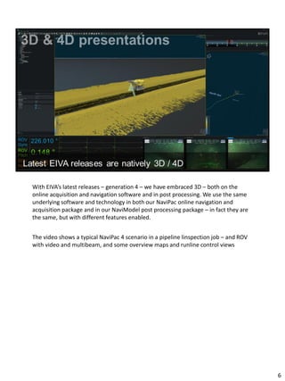
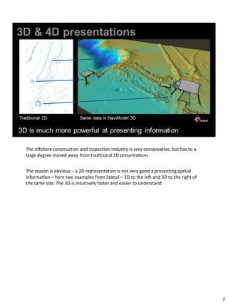
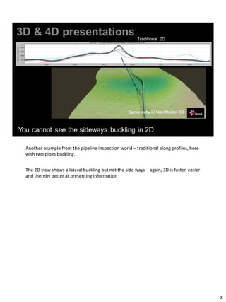
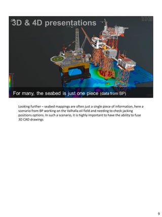
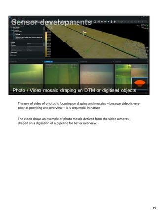
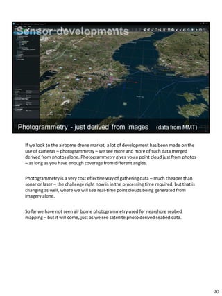
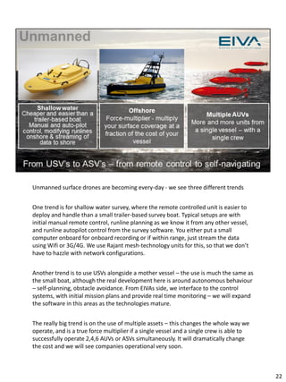
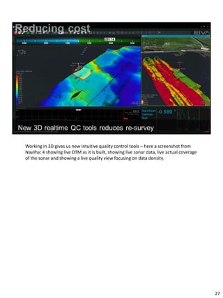
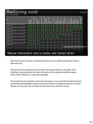
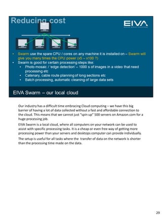
1
Introduction
Topics covered – short EIVA presentation, 5 trends we see in our part of the industry,
something on our latest developments and near term roadmap – and a small gift for
some of you.
2
For those of you that do not know EIVA – we are a Danish based, internationally
focused company, and have been in the survey / offshore industry since 1978. We
have own staff in Denmark, Germany, UK, US, Singapore and Phillipines – but mostly
we are working through our network of resellers. We are privately owned, CEO being
one of three major shareholders, financially strong, despite the current climate in
oil&gas and related sectors.
3
EIVA have its origin in the offshore construction sector – rig moves, pipeline
inspections, placement of offshore wind turbines etc
These segments uses and perhaps even drives the development on a lot of the
sensors used in the more traditional Hydrographic segment
We look at Hydrography as a broad set of activities
- Of course Nautical Navigation Chart production of course, but this is only a small
portion
- Site surveys for offshore construction
- Harbour surveys
- Asset inspections
- Etc etc
4
Lets talk about some of the trends we see in our industry, the first being the
adaptation of 3D and 4D software.
We use the term 4D with TIME as the 4th dimension, ie 4D as real time 3D and 4D as
3D comparisons over time.
5
With EIVA’s latest releases – generation 4 – we have embraced 3D – both on the
online acquisition and navigation software and in post processing. We use the same
underlying software and technology in both our NaviPac online navigation and
acquisition package and in our NaviModel post processing package – in fact they are
the same, but with different features enabled.
The video shows a typical NaviPac 4 scenario in a pipeline linspection job – and ROV
with video and multibeam, and some overview maps and runline control views
6
The offshore construction and inspection industry is very conservative, but has to a
large degree moved away from traditional 2D presentations
The reason is obvious – a 2D representation is not very good a presenting spatial
information – here two examples from Statoil – 2D to the left and 3D to the right of
the same site. The 3D is intuitively faster and easier to understand
7
Another example from the pipeline inspection world – traditional along profiles, here
with two pipes buckling.
The 2D view shows a lateral buckling but not the side ways – again, 3D is faster, easier
and thereby better at presenting information
8
Looking further – seabed mappings are often just a single piece of information, here a
scenario from BP working on the Valhalla oil field and needing to check jacking
positions options. In such a scenario, it is highly important to have the ability to fuse
3D CAD drawings
9
When we look at the traditional hydrographic task of producing navigation charts, we
are often puzzled at why almost all of the work products are focused on 2D – I am a
sailor myself, and it is many years since I have used paper maps for other than as a
curiosity – 20 years ago for backup yes, but now, the backup is the Ipad and the
Iphone. When we look at the hydrographic process, it is also a paradox that the
finalisation of products, ie the charting is a long and expensive process – where we
effectively spend a lot of time removing information from 3D data to bring it into a
format that was derived when we only had paper charts available. I believe it is time
to derive new standards and end products matching the technology available.
10
The advancements in 3D technology is diven by the game industry, and we are now at
a stage where Virtual Reality is finding its way for real. We have implemented support
for Oculus Rift glasses in our software, which is a great gimmick – we still need to see
application areas that create real business value.
One area is obvious - when we talk about 3D subsea navigation, it is great, so ROV
pilots are in for a new experience.
For post processing – not sure at this point, but lets see
My guess is that what we are seeing on VR is just the early beginning.
11
The second trend I will mention is large data
12
There is LARGE data and then BIG data
We work with large data sets in our industry
Hydrographic software must be able to handle very large amounts of data – and we
need to embrace BIG DATA
The video is several years of survey around the west coast of Greenland – easily
handled in a single project inside NaviModel.
The video shows a major challenge – the lack of surveyed area is a challenge for
everyone operating in such areas – EIVA has provided navigation displays that use just
the above sonar display to allow vessels to operate even when there is no map. In
remote locations like this – any information is better than none.
13
We are working with very large data sets in our industry, and it is growing rapidly
Some parts of the world are still working with simple, single-beam surveys, most in
our part of the world has adopted multibeam echosounders. The sonar producers
have giving us more data because of backscatter and water column recording, and if
we look to EIVAs customers, the use of LiDAR both terrestrial and subsea and
video/imagery has been increased the size of data manifold. Todays systems handle
all this.
We are now at a point, where data size is about to explode once more – the use of
unmanned systems, AUVs, USV, and not just one, but many from a single vessel – this
will multiple the amount of data we are dealing with in time.
14
When we look at one of the mega-trends in IT, BIG DATA, our industry yet has to
embrace it. We think of BIG DATA as different from just large data sets, but we have
customers that have the potential of utilising BIG DATA concepts – the ability to
derive information across very large collections of data sets.
We see some examples, for example when we use AIS tracks to build statistics of
where there is most traffic and therefore highest risk of damages to subsea assets –
but the examples are few - right now.
One of our customers, have mode than 2500 NaviModel projects gathered over time,
ie multiple surveys of the same areas – a source of information gives the basis for
new approaches, for example machine learning. We see pipeline inspection jobs
where as many as 150.000 events are registered, ie points of interest. Across those
2500 projects, we have millions of data samples – all well suited for machine learning
– enabling the software to define events and perform quality control of events rather
than requiring an operator.
15
The third (of the five) trends is on sensor developments
We have gone from Single Beam sonars to Multi-Beam sonars.
We see relatively little development on the sonar side – probably because of simple
physics of acoustic behaviour in water. (sonar producers will probably not agree with
me on this)
Looking at other sensor types, there is huge development.
We see the wildest subsea survey spreads – quad-head multibeam, gap filler sonar,
gap filler laser, high resolution imagery – at high speed.
16
For shallow water / coastal surveys, it is becoming the norm to combine sonar with
terrestrial LiDAR
The videos shows such a harbour scan inside NaviModel
17
For subsea construction, the lastest developments are on subsea lasers, giving
milimeter accuracy, and enabling super detailed AUV / ROV based surveys. A high
precision laser is not more expensive that a good multi-beam sonar.
The screenshots is from a survey made with 2GRobotics and Sonardyne – from and
ROV, and giving millimetre accuracy sufficient for what we call metrology – a
discipline of measuring distances between installations in order to perform subsea
installation with ROVs.
We have earlier this year experimented with laser for shallow water surveys, and that
is not without problems due to ambient light, water clarity etc. – laser like working in
the dark.
18
The use of video of photos is focusing on draping and mosaics – because video is very
poor at providing and overview – it is sequential in nature
The video shows an example of photo mosaic derived from the video cameras –
draped on a digisation of a pipeline for better overview.
19
If we look to the airborne drone market, a lot of development has been made on the
use of cameras – photogrammetry – we see more and more of such data merged
derived from photos alone. Photogrammetry gives you a point cloud just from photos
– as long as you have enough coverage from different angles.
Photogrammetry is a very cost effective way of gathering data – much cheaper than
sonar or laser – the challenge right now is in the processing time required, but that is
changing as well, where we will see real-time point clouds being generated from
imagery alone.
So far we have not seen air borne photogrammetry used for nearshore seabed
mapping – but it will come, just as we see satellite photo derived seabed data.
20
One of the most interesting areas of development is on the Unmanned systems –
AUVs, USVs, ASVs etc
21
Unmanned surface drones are becoming every-day - we see three different trends
One trend is for shallow water survey, where the remote controlled unit is easier to
deploy and handle than a small trailer-based survey boat. Typical setups are with
initial manual remote control, runline planning as we know it from any other vessel,
and runline autopilot control from the survey software. You either put a small
computer onboard for onboard recording or if within range, just stream the data
using Wifi or 3G/4G. We use Rajant mesh-technology units for this, so that we don’t
have to hazzle with network configurations.
Another trend is to use USVs alongside a mother vessel – the use is much the same as
the small boat, although the real development here is around autonomous behaviour
– self-planning, obstacle avoidance. From EIVAs side, we interface to the control
systems, with initial mission plans and provide real time monitoring – we will expand
the software in this areas as the technologies mature.
The really big trend is on the use of multiple assets – this changes the whole way we
operate, and is a true force multiplier if a single vessel and a single crew is able to
successfully operate 2,4,6 AUVs or ASVs simultaneously. It will dramatically change
the cost and we will see companies operational very soon.
22
Unmanned systems, especially underwater units, are changing the way we normally
operate
A traditional surface vessel surface is working with a cycle of acquisition and
processing, where eg 15min of data is recorded, which is then processed – an endless
loop, 24/7. The higher the cost of re-survey is – errors have to be found fast.
Some customers stream the data onshore – having calculated that onshore personnel
+ satellite comms is cheaper than onboard, others do all the processing onboard with
as small a crew as possible – and others again do a mixture of onboard and onshore.
For AUVs, we see few customers running post processing software onboard the drone
– for two main reasons A) power is limited and B) there are steps that needs to be
performed afterwards anyway, such as reprocessing of INS data – so the benefit on
onboard processing is low. Instead, we are focusing on speed and on automation on
the mother vessel.
Regardless of the operational setup, speed of processing is of value – this is why you
see a lot of EIVA’s news centered around faster performance one way or the other.
23
The fifth trend is cost reduction
The most important dialogue we have with all our large customers is around how to
optimise their business
24
Our industry is working with some very expensive assets – survey vessels cost multi-
million EUR, and thousands of EUR per day to operate.
The cost of the vessel, cost of survey spread and cost of man-time is what we are
focusing one – how we can survey more, faster and cheaper.
Much of EIVAs development is focused on this
25
Starting at the planning stage, we have introduced more and more intelligent mission
planning / runline definition tools. Since we are working with 3D data, we have tools
that use previously knowledge of terrain, vessel speed, sonar swath, ping rate etc to
provide better runlines that ensures sufficient coverage but minimizes sailing time.
This is valuable for surface vessels – but for subsea autonomous units, this is essential
- because you really don’t like finding out that you have many gaps to fill on a large
AUV survey
26
Working in 3D gives us new intuitive quality control tools – here a screenshot from
NaviPac 4 showing live DTM as it is built, showing live sonar data, live actual coverage
of the sonar and showing a live quality view focusing on data density.
27
With the massive increase in data be collected, we are implementing now tools to
deal with that.
We are focused on getting rid of as many manual operations as possible, and a
building a new production line tool that covers all the possible workflow steps –
within EIVA software or using other packages
The production line tool gives overview of progress, it ensures that all steps has been
performed, and highlights quality errors that needs to be addressed by the surveyor.
Ideally, we only want the surveyor to deal with errors and final review.
28
Our industry has a difficult time embracing Cloud computing – we have this big
barrier of having a lot of data collected without a fast and affordable connection to
the cloud. This means that we cannot just “spin up” 500 servers on Amazon.com for a
huge processing job.
EIVA Swarm is a local cloud, where all computers on your network can be used to
assist with specific processing tasks. It is a cheap or even free way of getting more
processing power than your servers and desktops computer can provide individually.
The setup is useful for all tasks where the transfer of data on the network is shorter
than the processing time made on the data.
29
Coming to the end of my presentation, let me share some of the latest developments
and give you a quick insight into what is coming from our side.
30
Earlier this year, we released a brand-new generation – we call it generation 4. Those
releases have much development behind it, and is too much to cover in this
presentation – the videos and screenshots you have seen earlier are all examples
from generation 4.
We are just in the final tests with another minor release, which have many interesting
areas of development relevant to hydrographic customers – in addition to the many
developments included for construction, dredging, pipe line inspection and
oceanographic use.
There are several performance improvements – for example a new version of our
automated cleaning algorithm S-CAN, which is now twice as fast. We estimate that it
is now 10 times faster than other automated algorithms.
A lot of development has been made around point clouds – because we see more
and more data being collected as point clouds and manipulated as point clouds.
The new QC tools included in NaviPac 4 are many – real time density, coverage,
quality, certainty models, real time difference models, and the ability to define your
31
own surface types, ie your own calculations on the different soundings.
We are including our automation robot – actually developed for our testing, but
useful at repeating tasks in a workflow.
New advanced tools such as SVP refraction calculations, that allows manipulation of
sound sound velocity profiles and interpolation between profiles – very useful in
areas of unmeasureable or highly varying sound velocity.
31
We rarely talk about our roadmap before it is going into release testing, but here are
some highlights for a few of the things our development team is working on this
autumn
- We are implementing a new TPE/TVU tool with a new approach and the ability to
show TPE/TVU surfaces and use the TPE values in calculations in custom surfaces
- We are implementing both the new GEOCODER and the new CUBE algorithms
from University of New Hampshire – for those hydrographic customers who prefer
those approaches. They can be used alongside our many other cleaning tools.
- The production line automation tool you saw earlier is coming early 2017
- We are working on even more advanced, self modifying real time runlines,
enabling you automatically create runlines as you sail based on actual coverage so
far
- .. And then of course the things we don’t want our colleagues in the market to
know about
32
I hope you found our presentation worth while
As a closing remark, for those of you who represent a Hydrograhic Office, we have a
gift if you are interested. We are donating one full package of our software for free –
fully supported, no strings attached.
For those of you that may be representing an educational institution, please note that
we provide free licenses for class room and teachers. More than 500 such licenses
were giving out in the past 12 months alone. No strings attached.
Thank you for your time – I am here the whole day, if you want to chat !
33

Software for survey and engineering at sea

  • 1.
  • 2.
    Introduction Topics covered –short EIVA presentation, 5 trends we see in our part of the industry, something on our latest developments and near term roadmap – and a small gift for some of you. 2
  • 3.
    For those ofyou that do not know EIVA – we are a Danish based, internationally focused company, and have been in the survey / offshore industry since 1978. We have own staff in Denmark, Germany, UK, US, Singapore and Phillipines – but mostly we are working through our network of resellers. We are privately owned, CEO being one of three major shareholders, financially strong, despite the current climate in oil&gas and related sectors. 3
  • 4.
    EIVA have itsorigin in the offshore construction sector – rig moves, pipeline inspections, placement of offshore wind turbines etc These segments uses and perhaps even drives the development on a lot of the sensors used in the more traditional Hydrographic segment We look at Hydrography as a broad set of activities - Of course Nautical Navigation Chart production of course, but this is only a small portion - Site surveys for offshore construction - Harbour surveys - Asset inspections - Etc etc 4
  • 5.
    Lets talk aboutsome of the trends we see in our industry, the first being the adaptation of 3D and 4D software. We use the term 4D with TIME as the 4th dimension, ie 4D as real time 3D and 4D as 3D comparisons over time. 5
  • 6.
    With EIVA’s latestreleases – generation 4 – we have embraced 3D – both on the online acquisition and navigation software and in post processing. We use the same underlying software and technology in both our NaviPac online navigation and acquisition package and in our NaviModel post processing package – in fact they are the same, but with different features enabled. The video shows a typical NaviPac 4 scenario in a pipeline linspection job – and ROV with video and multibeam, and some overview maps and runline control views 6
  • 7.
    The offshore constructionand inspection industry is very conservative, but has to a large degree moved away from traditional 2D presentations The reason is obvious – a 2D representation is not very good a presenting spatial information – here two examples from Statoil – 2D to the left and 3D to the right of the same site. The 3D is intuitively faster and easier to understand 7
  • 8.
    Another example fromthe pipeline inspection world – traditional along profiles, here with two pipes buckling. The 2D view shows a lateral buckling but not the side ways – again, 3D is faster, easier and thereby better at presenting information 8
  • 9.
    Looking further –seabed mappings are often just a single piece of information, here a scenario from BP working on the Valhalla oil field and needing to check jacking positions options. In such a scenario, it is highly important to have the ability to fuse 3D CAD drawings 9
  • 10.
    When we lookat the traditional hydrographic task of producing navigation charts, we are often puzzled at why almost all of the work products are focused on 2D – I am a sailor myself, and it is many years since I have used paper maps for other than as a curiosity – 20 years ago for backup yes, but now, the backup is the Ipad and the Iphone. When we look at the hydrographic process, it is also a paradox that the finalisation of products, ie the charting is a long and expensive process – where we effectively spend a lot of time removing information from 3D data to bring it into a format that was derived when we only had paper charts available. I believe it is time to derive new standards and end products matching the technology available. 10
  • 11.
    The advancements in3D technology is diven by the game industry, and we are now at a stage where Virtual Reality is finding its way for real. We have implemented support for Oculus Rift glasses in our software, which is a great gimmick – we still need to see application areas that create real business value. One area is obvious - when we talk about 3D subsea navigation, it is great, so ROV pilots are in for a new experience. For post processing – not sure at this point, but lets see My guess is that what we are seeing on VR is just the early beginning. 11
  • 12.
    The second trendI will mention is large data 12
  • 13.
    There is LARGEdata and then BIG data We work with large data sets in our industry Hydrographic software must be able to handle very large amounts of data – and we need to embrace BIG DATA The video is several years of survey around the west coast of Greenland – easily handled in a single project inside NaviModel. The video shows a major challenge – the lack of surveyed area is a challenge for everyone operating in such areas – EIVA has provided navigation displays that use just the above sonar display to allow vessels to operate even when there is no map. In remote locations like this – any information is better than none. 13
  • 14.
    We are workingwith very large data sets in our industry, and it is growing rapidly Some parts of the world are still working with simple, single-beam surveys, most in our part of the world has adopted multibeam echosounders. The sonar producers have giving us more data because of backscatter and water column recording, and if we look to EIVAs customers, the use of LiDAR both terrestrial and subsea and video/imagery has been increased the size of data manifold. Todays systems handle all this. We are now at a point, where data size is about to explode once more – the use of unmanned systems, AUVs, USV, and not just one, but many from a single vessel – this will multiple the amount of data we are dealing with in time. 14
  • 15.
    When we lookat one of the mega-trends in IT, BIG DATA, our industry yet has to embrace it. We think of BIG DATA as different from just large data sets, but we have customers that have the potential of utilising BIG DATA concepts – the ability to derive information across very large collections of data sets. We see some examples, for example when we use AIS tracks to build statistics of where there is most traffic and therefore highest risk of damages to subsea assets – but the examples are few - right now. One of our customers, have mode than 2500 NaviModel projects gathered over time, ie multiple surveys of the same areas – a source of information gives the basis for new approaches, for example machine learning. We see pipeline inspection jobs where as many as 150.000 events are registered, ie points of interest. Across those 2500 projects, we have millions of data samples – all well suited for machine learning – enabling the software to define events and perform quality control of events rather than requiring an operator. 15
  • 16.
    The third (ofthe five) trends is on sensor developments We have gone from Single Beam sonars to Multi-Beam sonars. We see relatively little development on the sonar side – probably because of simple physics of acoustic behaviour in water. (sonar producers will probably not agree with me on this) Looking at other sensor types, there is huge development. We see the wildest subsea survey spreads – quad-head multibeam, gap filler sonar, gap filler laser, high resolution imagery – at high speed. 16
  • 17.
    For shallow water/ coastal surveys, it is becoming the norm to combine sonar with terrestrial LiDAR The videos shows such a harbour scan inside NaviModel 17
  • 18.
    For subsea construction,the lastest developments are on subsea lasers, giving milimeter accuracy, and enabling super detailed AUV / ROV based surveys. A high precision laser is not more expensive that a good multi-beam sonar. The screenshots is from a survey made with 2GRobotics and Sonardyne – from and ROV, and giving millimetre accuracy sufficient for what we call metrology – a discipline of measuring distances between installations in order to perform subsea installation with ROVs. We have earlier this year experimented with laser for shallow water surveys, and that is not without problems due to ambient light, water clarity etc. – laser like working in the dark. 18
  • 19.
    The use ofvideo of photos is focusing on draping and mosaics – because video is very poor at providing and overview – it is sequential in nature The video shows an example of photo mosaic derived from the video cameras – draped on a digisation of a pipeline for better overview. 19
  • 20.
    If we lookto the airborne drone market, a lot of development has been made on the use of cameras – photogrammetry – we see more and more of such data merged derived from photos alone. Photogrammetry gives you a point cloud just from photos – as long as you have enough coverage from different angles. Photogrammetry is a very cost effective way of gathering data – much cheaper than sonar or laser – the challenge right now is in the processing time required, but that is changing as well, where we will see real-time point clouds being generated from imagery alone. So far we have not seen air borne photogrammetry used for nearshore seabed mapping – but it will come, just as we see satellite photo derived seabed data. 20
  • 21.
    One of themost interesting areas of development is on the Unmanned systems – AUVs, USVs, ASVs etc 21
  • 22.
    Unmanned surface dronesare becoming every-day - we see three different trends One trend is for shallow water survey, where the remote controlled unit is easier to deploy and handle than a small trailer-based survey boat. Typical setups are with initial manual remote control, runline planning as we know it from any other vessel, and runline autopilot control from the survey software. You either put a small computer onboard for onboard recording or if within range, just stream the data using Wifi or 3G/4G. We use Rajant mesh-technology units for this, so that we don’t have to hazzle with network configurations. Another trend is to use USVs alongside a mother vessel – the use is much the same as the small boat, although the real development here is around autonomous behaviour – self-planning, obstacle avoidance. From EIVAs side, we interface to the control systems, with initial mission plans and provide real time monitoring – we will expand the software in this areas as the technologies mature. The really big trend is on the use of multiple assets – this changes the whole way we operate, and is a true force multiplier if a single vessel and a single crew is able to successfully operate 2,4,6 AUVs or ASVs simultaneously. It will dramatically change the cost and we will see companies operational very soon. 22
  • 23.
    Unmanned systems, especiallyunderwater units, are changing the way we normally operate A traditional surface vessel surface is working with a cycle of acquisition and processing, where eg 15min of data is recorded, which is then processed – an endless loop, 24/7. The higher the cost of re-survey is – errors have to be found fast. Some customers stream the data onshore – having calculated that onshore personnel + satellite comms is cheaper than onboard, others do all the processing onboard with as small a crew as possible – and others again do a mixture of onboard and onshore. For AUVs, we see few customers running post processing software onboard the drone – for two main reasons A) power is limited and B) there are steps that needs to be performed afterwards anyway, such as reprocessing of INS data – so the benefit on onboard processing is low. Instead, we are focusing on speed and on automation on the mother vessel. Regardless of the operational setup, speed of processing is of value – this is why you see a lot of EIVA’s news centered around faster performance one way or the other. 23
  • 24.
    The fifth trendis cost reduction The most important dialogue we have with all our large customers is around how to optimise their business 24
  • 25.
    Our industry isworking with some very expensive assets – survey vessels cost multi- million EUR, and thousands of EUR per day to operate. The cost of the vessel, cost of survey spread and cost of man-time is what we are focusing one – how we can survey more, faster and cheaper. Much of EIVAs development is focused on this 25
  • 26.
    Starting at theplanning stage, we have introduced more and more intelligent mission planning / runline definition tools. Since we are working with 3D data, we have tools that use previously knowledge of terrain, vessel speed, sonar swath, ping rate etc to provide better runlines that ensures sufficient coverage but minimizes sailing time. This is valuable for surface vessels – but for subsea autonomous units, this is essential - because you really don’t like finding out that you have many gaps to fill on a large AUV survey 26
  • 27.
    Working in 3Dgives us new intuitive quality control tools – here a screenshot from NaviPac 4 showing live DTM as it is built, showing live sonar data, live actual coverage of the sonar and showing a live quality view focusing on data density. 27
  • 28.
    With the massiveincrease in data be collected, we are implementing now tools to deal with that. We are focused on getting rid of as many manual operations as possible, and a building a new production line tool that covers all the possible workflow steps – within EIVA software or using other packages The production line tool gives overview of progress, it ensures that all steps has been performed, and highlights quality errors that needs to be addressed by the surveyor. Ideally, we only want the surveyor to deal with errors and final review. 28
  • 29.
    Our industry hasa difficult time embracing Cloud computing – we have this big barrier of having a lot of data collected without a fast and affordable connection to the cloud. This means that we cannot just “spin up” 500 servers on Amazon.com for a huge processing job. EIVA Swarm is a local cloud, where all computers on your network can be used to assist with specific processing tasks. It is a cheap or even free way of getting more processing power than your servers and desktops computer can provide individually. The setup is useful for all tasks where the transfer of data on the network is shorter than the processing time made on the data. 29
  • 30.
    Coming to theend of my presentation, let me share some of the latest developments and give you a quick insight into what is coming from our side. 30
  • 31.
    Earlier this year,we released a brand-new generation – we call it generation 4. Those releases have much development behind it, and is too much to cover in this presentation – the videos and screenshots you have seen earlier are all examples from generation 4. We are just in the final tests with another minor release, which have many interesting areas of development relevant to hydrographic customers – in addition to the many developments included for construction, dredging, pipe line inspection and oceanographic use. There are several performance improvements – for example a new version of our automated cleaning algorithm S-CAN, which is now twice as fast. We estimate that it is now 10 times faster than other automated algorithms. A lot of development has been made around point clouds – because we see more and more data being collected as point clouds and manipulated as point clouds. The new QC tools included in NaviPac 4 are many – real time density, coverage, quality, certainty models, real time difference models, and the ability to define your 31
  • 32.
    own surface types,ie your own calculations on the different soundings. We are including our automation robot – actually developed for our testing, but useful at repeating tasks in a workflow. New advanced tools such as SVP refraction calculations, that allows manipulation of sound sound velocity profiles and interpolation between profiles – very useful in areas of unmeasureable or highly varying sound velocity. 31
  • 33.
    We rarely talkabout our roadmap before it is going into release testing, but here are some highlights for a few of the things our development team is working on this autumn - We are implementing a new TPE/TVU tool with a new approach and the ability to show TPE/TVU surfaces and use the TPE values in calculations in custom surfaces - We are implementing both the new GEOCODER and the new CUBE algorithms from University of New Hampshire – for those hydrographic customers who prefer those approaches. They can be used alongside our many other cleaning tools. - The production line automation tool you saw earlier is coming early 2017 - We are working on even more advanced, self modifying real time runlines, enabling you automatically create runlines as you sail based on actual coverage so far - .. And then of course the things we don’t want our colleagues in the market to know about 32
  • 34.
    I hope youfound our presentation worth while As a closing remark, for those of you who represent a Hydrograhic Office, we have a gift if you are interested. We are donating one full package of our software for free – fully supported, no strings attached. For those of you that may be representing an educational institution, please note that we provide free licenses for class room and teachers. More than 500 such licenses were giving out in the past 12 months alone. No strings attached. Thank you for your time – I am here the whole day, if you want to chat ! 33