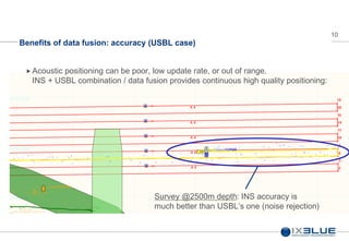
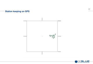
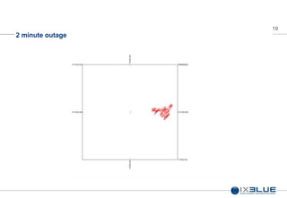
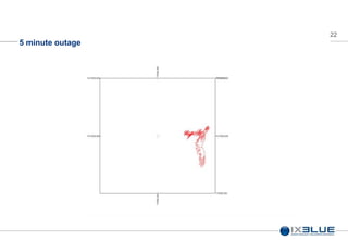
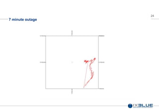
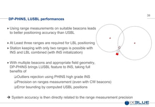
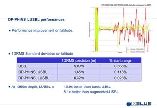
INS for DP – Methods – Full Version
IMCA Annual Seminar Singapore, November 2013, Jim Titcomb, Yann Casamajou
INS Introduction
3
What's in an INS?
What is an Inertial Navigation System (INS)?
An instrument (electronic + sensors) which is using its initial state (position)
and internal motion sensors (gyroscopes + accelerometers) to measure and
calculate its subsequent positions in space with high accuracy, stability and
update rate
PHINS PHINS 6000 ROVINS
4
What's in an INS?
3 “FOG” gyrometers
monitor rotation and speed in X, Y & Z axis
 3 accelerometers
measure acceleration (>> speed >> motion) in 3 axis
 Powerful electronic / firmware package
PHINS “knows” in real time its motion in space .
Firmware (Kalman filter) calculates its position in real
time + heading, pitch, roll, heave, etc…
All integrated
small, lean, powerful!
(PHINS 6000 example)
5
INS Introduction
What makes an INS good.. or not?
 Internal sensors (gyroscopes & accelerometers) are never perfect, bias and
scale factors accumulate over time
 Navigation is mostly about Gyroscopes
 Gross figures:
 Accelerometers errors are not heavily involved in the position drift – 4m –
Schuller period
 Gyroscope are heavily involved in the drift – 400 m
 Conclusions
 A good INS requires good gyro’s
 IXBLUE manufactures FOG (Fiber Optic Gyroscope) and controls the whole
process
 A range of FOG’s (FOG90, FOG120, FOG180…) for a range of INS
6
INS Introduction
The best sensors are still not perfect, accumulating small errors vs. time
makes the system drift on the long term
 External sensors (aiding) are required to bound drift within acceptable limits.
PHINS & ROVINS includes interfaces for most common external sensors
 GPS
 DVL (Doppler Velocity Log)
 Pressure sensor
 Acoustic positioning references (USBL, LBL)
 …and all IXBLUE products!
 IXBLUE INS are fully integrated Inertial Positioning solutions designed for
ease of installation & operation, flexible enough to fit most requirements, with
no specialist engineer to install / operate.
7
Benefits of data fusion: Robustness to signal losses
GPS positioning
with masking
8
Benefits of data fusion: outages
GPS + INS
positioning with
masking
9
Benefits of data fusion: accuracy
Data Fusion
 Use various and different technologies to measure the same parameter
 Blend (fuse all this data (Kalman filter) in order to correlate it and obtain a better result
 A simple example GPS + INS (PHINS or GAPS typical use case)
0
0,5
1
1,5
2
2,5
3
0 20 40 60 80 100
time t (s)
positionaccuracy(m)
PHINS pure inertial drift (0.0002 x t^2
m)
Averaging of DGPS data (3 / sqrt(t)
m)
PHINS+DGPS
10
Benefits of data fusion: accuracy (USBL case)
Acoustic positioning can be poor, low update rate, or out of range.
INS + USBL combination / data fusion provides continuous high quality positioning:
Survey @2500m depth: INS accuracy is
much better than USBL’s one (noise rejection)
DP-PHINS : Bringing INS benefits to DP
12
DP-PHINS What is it?
Missing link between PHINS and USBL PME
Goals of the system :
DP-PHINS cabinet extends PHINS capabilities to :
Context:
Offshore works and installation jobs
Deep sea (>1000m)
Necessity to pursue operations without any reliable GPS
Severe daily scintillation phenomena (Africa, Brazil...)
Use PHINS fusion algorithms to enhance raw USBL positioning
Improve USBL performances to make it usable for DP during
GPS scintillation
use raw acoustic detections from any USBL for positioning
provide positioning telegram to DP Desk
13
DP-PHINS What is it?
Time Signals
Time and Position
For Initialisation Only
Time stamped beacon
positions and heading
Processed
Positions
Enhanced Position
Acoustic
Positions
14
DP- PHINS, Features
 PHINS Natural Features:
 Native fusion of a wide range of sensors (GPS, DVL...)
 Strong noise rejection
 Sparse-array capability
 DP-PHINS cabinet additional improvements:
 Relative to Global co-ordinate transforms
 Unlimited number of beacon
 Sparse array LBL
 Flexible
 Expandable
 Future Sensors
 Taught Wire
 Fan Beam
 Radascan
 Etc. Etc.
15
Why this approach?
Augmented GNSS is an accurate and generally reliable positioning solution.
 For DP in deep water, the primary issue would seem to be lack of other
available positioning systems.
 What to do in water that is too deep for useful acoustics?
 After a certain depth acoustics become too noisy, too deep for taut wire, no
other structures for relative based systems.
Too many vessels relying on single PME – GNSS
 What does INS give you when you are relying on GNSS?
Data Example – Single PME
17
Station keeping on GPS
18
1 minute outage
19
2 minute outage
20
3 minute outage
21
4 minute outage
22
5 minute outage
23
6 minute outage
24
7 minute outage
25
8 minute outage
26
9 minute outage
27
10 minute outage
11m in 10 minutes
28
20 minute outage
38m in 20 minutes
29
Whats the alternative?
INS will drift quickly if the aiding sensor fails.
 3m in 2 min,
 20m in 5 min.
 0.6Nmi in an hour
 When using INS with a single aiding sensor, a single failure will take out your
INS also.
 INS is most effective with multiple aiding sensors.
 INS SHOULD be used with multiple aiding sensors.
DP-PHINS : Multiple aiding sensors
31
DP-PHINS: what if the positioning source fails ?
 INS free inertial specification is based on time. The more time, the greater the drift.
 Adding a DVL to DP-PHINS is an option to contain this drift
DVL aided INS specification is based on distance travelled. If you don’t move the error
can’t grow as much.
 PHINS-DVL performance is still good at low update rate  compatible with deep water
 Problem: DVL is only available in water depths up to around 1,000m
DVL Update
Rate
Error, %
travelled
distance
Drift speed
m/h
1S 0.03% 0.18
2S 0.13% 0.82
3S 0.26% 1.67
4S 0.27% 1.77
6S 0.32% 2.08
8s 0.30% 1.98
32
DP- PHINS Performances:
Augmented USBL, case 1
USBL raw data
PHINS + USBL, SD live
PHINS + DGPS
Nov2012: 1300m depth operations
Single vessel, 2 cases:
DP with manoeuvring operations
1x standard omnidirectional transducer, tonal codes
DP with static vessel position
1x directional transducer  improved USBL accuracy
Accuracy Gain
x3.3
x2.65
Accuracy
(%slant range)
0.055%
0.035%
Test CASE
USBL SD
(1DRMS,DGPS ref)
DP-PHINS SD
(1DRMS,DGPS ref)
Dynamic, omni 2.34m 0.71m
Static, directional 1.22m 0.46m
DP-PHINS raises USBL PME
to submetric performances on
performing vessels
33
DP- PHINS Performances:
Augmented USBL, case 2
Less performing USBL
Kongsberg CAT, 1360m depth
Standard tonal transponders
DP performances in dynamic test
Error Type
USBL vs GPS
accuracy
PHINS vs GPS
accuracy
max 86,79m 7,94m
1DRMS 6,21m 2,64m
Accuracy GAIN
(GPS ref)
x10,93
x2,35
% Slant range
0.57%
0.19%
DP-PHINS raises poor DP-USBL
to acceptable levels of
performances in most fields
34
Acoustic Aiding Examples - Recap
ROV on Seabed.
 850m water depth
 Well calibrated USBL
 About as good as it gets with
USBL
Standard
Deviation
X Y Position
USBL 1.03 0.86 1.34
35
INS Aided with USBL - Recap
Spikes in USBL rejected
Automatically.
 Much higher update rate.
 Smoother positioning.
 Reduced spread of positions.
 5 X improvement with INS
Standard
Deviation
X Y
USBL 1.03 0.86 1.34
INS 0.16 0.2 0.26
36
INS Aided with USBL & DVL
DVL update only every 3
seconds
 Positioning now better than
high accuracy GPS even in
850m
 17 x Better than raw
acoustics.
Standard
Deviation
X Y
USBL 1.03 0.86 1.34
INS 0.16 0.2 0.26
With DVL 0.05 0.06 0.07
37
What if we lose acoustics?
DVL update only every 3
seconds
 Positioning now better than
high accuracy GPS even in
850m
Standard
Deviation
X Y
USBL 1.03 0.86 1.34
INS 0.16 0.2 0.26
With DVL 0.05 0.06 0.07
INS DVL 0.04 0.02 0.05
DP-PHINS : Future Developments
39
DP-PHINS, LUSBL performances
 Using range measurements on suitable beacons leads
to better positioning accuracy than USBL
 At Least three ranges are required for LBL positioning
 Station keeping with only two ranges is possible with
INS and LBL combined (with INS initialization)
 With multiple beacons and appropriate field geometry,
DP-PHINS brings LUSBL feature to INS, taking full
benefits of
 Outliers rejection using PHINS high grade INS
 Precision on ranges measurement (even with CW beacons)
 Error bounding by computed USBL positions
 System accuracy is then directly related to the range measurement precision
40
DP-PHINS, LUSBL Accuracy and Geometry
Accuracy of results is
dependant on a combination
of geometry and range
measurement accuracy
If the beacons are “in line” with the vessel, LUSBL improvement will be
 Optimum on beacon axis
 Poor orthogonally to beacon axis…
 …. But still bounded by USBL precision
 Accuracy will be optimum on both axis if there is a high “Angle of cut”
DP-PHINS naturally takes the
best of USBL angles and
distances information
41
DP-PHINS, LUSBL performances
In May this year iXBlue commissioned DP-PHINS
onboard Subsea7 vessel Simar Esperanca.
 Augmented-USBL brings x2 to x3 improvement
over raw USBL, operating in over 1,350m on
acoustics
 LUSBL makes it even better
 Most of the USBL error is on the angle
measurements
 Range measurements are always consistent
 Simply add a beacon... And take the full benefit of
DP-PHINS !
DP-PHINS operating in 1364m (4475ft)
42
DP-PHINS, LUSBL performances
 The range measurements are far more
precise than the angle measurements.
 Slant range standard deviation on CW
signals: <30cm 1DRMS
B14
B15
Vessel
2 beacons used during this test
B14, 312m north
B15, 285m south
 LUSBL achievements in such a situation:
Optimum precision on latitude
No improvement on longitude
43
DP-PHINS, LUSBL performances
Performance improvement on latitude:
1DRMS Standard deviation on latitude
1DRMS precision (m) % slant range
USBL 5.09m 0.365%
DP-PHINS, USBL 1.65m 0.118%
DP-PHINS, LUSBL 0.32m 0.023%
At 1360m depth, LUSBL is 15.9x better than basic USBL
5.1x better than augmented-USBL
Conclusions
45
Conclusion: DP-PHINS as a PME
 INS is a proven technology on Land, Under water, in Space, why not in DP?
 INS has a long track record, Modern FOG based systems bring extreme
robustness and reliability.
 INS can produce heading and attitude data as well as positioning.
 INS Should not be aided just by GPS for DP applications.
 DP-PHINS can make your acoustics as good as high accuracy GPS.
 The biggest benefits can be obtained by combining aiding sensors.
 With the addition of DVL, PHINS can even be considered a stand alone PME
for a significant period of time.
46
Conclusion: Why moving to DP-PHINS ?
 Intrinsic performance improvement due to PHINS IMU performances
Augmented-USBL: x2 to x3 better than USBL with single USBL beacon
 Augmented-LUSBL: up to 16x times better with additional beacons
 Sequential use of beacons for LUSBL ➯ battery savings of field transponders
 Extended acceptable water depth for DP ➯ extended DP class
 Continued operation in case GPS outage ➯ recurring financial gain
 Easy refit of vessels with existing USBL
➯ unchanged USBL, pole… DP-PHINS can be installed anywhere on board
 Fuel saving thanks to DP-PHINS output position smoothness
 Positioning system open to any additional sensor (DVL, deep water CVL…)
47
Thanks for your attention
www.ixblue.com

Ins for dp methods full

  • 1.
    INS for DP– Methods – Full Version IMCA Annual Seminar Singapore, November 2013, Jim Titcomb, Yann Casamajou
  • 2.
  • 3.
    3 What's in anINS? What is an Inertial Navigation System (INS)? An instrument (electronic + sensors) which is using its initial state (position) and internal motion sensors (gyroscopes + accelerometers) to measure and calculate its subsequent positions in space with high accuracy, stability and update rate PHINS PHINS 6000 ROVINS
  • 4.
    4 What's in anINS? 3 “FOG” gyrometers monitor rotation and speed in X, Y & Z axis  3 accelerometers measure acceleration (>> speed >> motion) in 3 axis  Powerful electronic / firmware package PHINS “knows” in real time its motion in space . Firmware (Kalman filter) calculates its position in real time + heading, pitch, roll, heave, etc… All integrated small, lean, powerful! (PHINS 6000 example)
  • 5.
    5 INS Introduction What makesan INS good.. or not?  Internal sensors (gyroscopes & accelerometers) are never perfect, bias and scale factors accumulate over time  Navigation is mostly about Gyroscopes  Gross figures:  Accelerometers errors are not heavily involved in the position drift – 4m – Schuller period  Gyroscope are heavily involved in the drift – 400 m  Conclusions  A good INS requires good gyro’s  IXBLUE manufactures FOG (Fiber Optic Gyroscope) and controls the whole process  A range of FOG’s (FOG90, FOG120, FOG180…) for a range of INS
  • 6.
    6 INS Introduction The bestsensors are still not perfect, accumulating small errors vs. time makes the system drift on the long term  External sensors (aiding) are required to bound drift within acceptable limits. PHINS & ROVINS includes interfaces for most common external sensors  GPS  DVL (Doppler Velocity Log)  Pressure sensor  Acoustic positioning references (USBL, LBL)  …and all IXBLUE products!  IXBLUE INS are fully integrated Inertial Positioning solutions designed for ease of installation & operation, flexible enough to fit most requirements, with no specialist engineer to install / operate.
  • 7.
    7 Benefits of datafusion: Robustness to signal losses GPS positioning with masking
  • 8.
    8 Benefits of datafusion: outages GPS + INS positioning with masking
  • 9.
    9 Benefits of datafusion: accuracy Data Fusion  Use various and different technologies to measure the same parameter  Blend (fuse all this data (Kalman filter) in order to correlate it and obtain a better result  A simple example GPS + INS (PHINS or GAPS typical use case) 0 0,5 1 1,5 2 2,5 3 0 20 40 60 80 100 time t (s) positionaccuracy(m) PHINS pure inertial drift (0.0002 x t^2 m) Averaging of DGPS data (3 / sqrt(t) m) PHINS+DGPS
  • 10.
    10 Benefits of datafusion: accuracy (USBL case) Acoustic positioning can be poor, low update rate, or out of range. INS + USBL combination / data fusion provides continuous high quality positioning: Survey @2500m depth: INS accuracy is much better than USBL’s one (noise rejection)
  • 11.
    DP-PHINS : BringingINS benefits to DP
  • 12.
    12 DP-PHINS What isit? Missing link between PHINS and USBL PME Goals of the system : DP-PHINS cabinet extends PHINS capabilities to : Context: Offshore works and installation jobs Deep sea (>1000m) Necessity to pursue operations without any reliable GPS Severe daily scintillation phenomena (Africa, Brazil...) Use PHINS fusion algorithms to enhance raw USBL positioning Improve USBL performances to make it usable for DP during GPS scintillation use raw acoustic detections from any USBL for positioning provide positioning telegram to DP Desk
  • 13.
    13 DP-PHINS What isit? Time Signals Time and Position For Initialisation Only Time stamped beacon positions and heading Processed Positions Enhanced Position Acoustic Positions
  • 14.
    14 DP- PHINS, Features PHINS Natural Features:  Native fusion of a wide range of sensors (GPS, DVL...)  Strong noise rejection  Sparse-array capability  DP-PHINS cabinet additional improvements:  Relative to Global co-ordinate transforms  Unlimited number of beacon  Sparse array LBL  Flexible  Expandable  Future Sensors  Taught Wire  Fan Beam  Radascan  Etc. Etc.
  • 15.
    15 Why this approach? AugmentedGNSS is an accurate and generally reliable positioning solution.  For DP in deep water, the primary issue would seem to be lack of other available positioning systems.  What to do in water that is too deep for useful acoustics?  After a certain depth acoustics become too noisy, too deep for taut wire, no other structures for relative based systems. Too many vessels relying on single PME – GNSS  What does INS give you when you are relying on GNSS?
  • 16.
    Data Example –Single PME
  • 17.
  • 18.
  • 19.
  • 20.
  • 21.
  • 22.
  • 23.
  • 24.
  • 25.
  • 26.
  • 27.
  • 28.
  • 29.
    29 Whats the alternative? INSwill drift quickly if the aiding sensor fails.  3m in 2 min,  20m in 5 min.  0.6Nmi in an hour  When using INS with a single aiding sensor, a single failure will take out your INS also.  INS is most effective with multiple aiding sensors.  INS SHOULD be used with multiple aiding sensors.
  • 30.
    DP-PHINS : Multipleaiding sensors
  • 31.
    31 DP-PHINS: what ifthe positioning source fails ?  INS free inertial specification is based on time. The more time, the greater the drift.  Adding a DVL to DP-PHINS is an option to contain this drift DVL aided INS specification is based on distance travelled. If you don’t move the error can’t grow as much.  PHINS-DVL performance is still good at low update rate  compatible with deep water  Problem: DVL is only available in water depths up to around 1,000m DVL Update Rate Error, % travelled distance Drift speed m/h 1S 0.03% 0.18 2S 0.13% 0.82 3S 0.26% 1.67 4S 0.27% 1.77 6S 0.32% 2.08 8s 0.30% 1.98
  • 32.
    32 DP- PHINS Performances: AugmentedUSBL, case 1 USBL raw data PHINS + USBL, SD live PHINS + DGPS Nov2012: 1300m depth operations Single vessel, 2 cases: DP with manoeuvring operations 1x standard omnidirectional transducer, tonal codes DP with static vessel position 1x directional transducer  improved USBL accuracy Accuracy Gain x3.3 x2.65 Accuracy (%slant range) 0.055% 0.035% Test CASE USBL SD (1DRMS,DGPS ref) DP-PHINS SD (1DRMS,DGPS ref) Dynamic, omni 2.34m 0.71m Static, directional 1.22m 0.46m DP-PHINS raises USBL PME to submetric performances on performing vessels
  • 33.
    33 DP- PHINS Performances: AugmentedUSBL, case 2 Less performing USBL Kongsberg CAT, 1360m depth Standard tonal transponders DP performances in dynamic test Error Type USBL vs GPS accuracy PHINS vs GPS accuracy max 86,79m 7,94m 1DRMS 6,21m 2,64m Accuracy GAIN (GPS ref) x10,93 x2,35 % Slant range 0.57% 0.19% DP-PHINS raises poor DP-USBL to acceptable levels of performances in most fields
  • 34.
    34 Acoustic Aiding Examples- Recap ROV on Seabed.  850m water depth  Well calibrated USBL  About as good as it gets with USBL Standard Deviation X Y Position USBL 1.03 0.86 1.34
  • 35.
    35 INS Aided withUSBL - Recap Spikes in USBL rejected Automatically.  Much higher update rate.  Smoother positioning.  Reduced spread of positions.  5 X improvement with INS Standard Deviation X Y USBL 1.03 0.86 1.34 INS 0.16 0.2 0.26
  • 36.
    36 INS Aided withUSBL & DVL DVL update only every 3 seconds  Positioning now better than high accuracy GPS even in 850m  17 x Better than raw acoustics. Standard Deviation X Y USBL 1.03 0.86 1.34 INS 0.16 0.2 0.26 With DVL 0.05 0.06 0.07
  • 37.
    37 What if welose acoustics? DVL update only every 3 seconds  Positioning now better than high accuracy GPS even in 850m Standard Deviation X Y USBL 1.03 0.86 1.34 INS 0.16 0.2 0.26 With DVL 0.05 0.06 0.07 INS DVL 0.04 0.02 0.05
  • 38.
    DP-PHINS : FutureDevelopments
  • 39.
    39 DP-PHINS, LUSBL performances Using range measurements on suitable beacons leads to better positioning accuracy than USBL  At Least three ranges are required for LBL positioning  Station keeping with only two ranges is possible with INS and LBL combined (with INS initialization)  With multiple beacons and appropriate field geometry, DP-PHINS brings LUSBL feature to INS, taking full benefits of  Outliers rejection using PHINS high grade INS  Precision on ranges measurement (even with CW beacons)  Error bounding by computed USBL positions  System accuracy is then directly related to the range measurement precision
  • 40.
    40 DP-PHINS, LUSBL Accuracyand Geometry Accuracy of results is dependant on a combination of geometry and range measurement accuracy If the beacons are “in line” with the vessel, LUSBL improvement will be  Optimum on beacon axis  Poor orthogonally to beacon axis…  …. But still bounded by USBL precision  Accuracy will be optimum on both axis if there is a high “Angle of cut” DP-PHINS naturally takes the best of USBL angles and distances information
  • 41.
    41 DP-PHINS, LUSBL performances InMay this year iXBlue commissioned DP-PHINS onboard Subsea7 vessel Simar Esperanca.  Augmented-USBL brings x2 to x3 improvement over raw USBL, operating in over 1,350m on acoustics  LUSBL makes it even better  Most of the USBL error is on the angle measurements  Range measurements are always consistent  Simply add a beacon... And take the full benefit of DP-PHINS ! DP-PHINS operating in 1364m (4475ft)
  • 42.
    42 DP-PHINS, LUSBL performances The range measurements are far more precise than the angle measurements.  Slant range standard deviation on CW signals: <30cm 1DRMS B14 B15 Vessel 2 beacons used during this test B14, 312m north B15, 285m south  LUSBL achievements in such a situation: Optimum precision on latitude No improvement on longitude
  • 43.
    43 DP-PHINS, LUSBL performances Performanceimprovement on latitude: 1DRMS Standard deviation on latitude 1DRMS precision (m) % slant range USBL 5.09m 0.365% DP-PHINS, USBL 1.65m 0.118% DP-PHINS, LUSBL 0.32m 0.023% At 1360m depth, LUSBL is 15.9x better than basic USBL 5.1x better than augmented-USBL
  • 44.
  • 45.
    45 Conclusion: DP-PHINS asa PME  INS is a proven technology on Land, Under water, in Space, why not in DP?  INS has a long track record, Modern FOG based systems bring extreme robustness and reliability.  INS can produce heading and attitude data as well as positioning.  INS Should not be aided just by GPS for DP applications.  DP-PHINS can make your acoustics as good as high accuracy GPS.  The biggest benefits can be obtained by combining aiding sensors.  With the addition of DVL, PHINS can even be considered a stand alone PME for a significant period of time.
  • 46.
    46 Conclusion: Why movingto DP-PHINS ?  Intrinsic performance improvement due to PHINS IMU performances Augmented-USBL: x2 to x3 better than USBL with single USBL beacon  Augmented-LUSBL: up to 16x times better with additional beacons  Sequential use of beacons for LUSBL ➯ battery savings of field transponders  Extended acceptable water depth for DP ➯ extended DP class  Continued operation in case GPS outage ➯ recurring financial gain  Easy refit of vessels with existing USBL ➯ unchanged USBL, pole… DP-PHINS can be installed anywhere on board  Fuel saving thanks to DP-PHINS output position smoothness  Positioning system open to any additional sensor (DVL, deep water CVL…)
  • 47.
    47 Thanks for yourattention www.ixblue.com