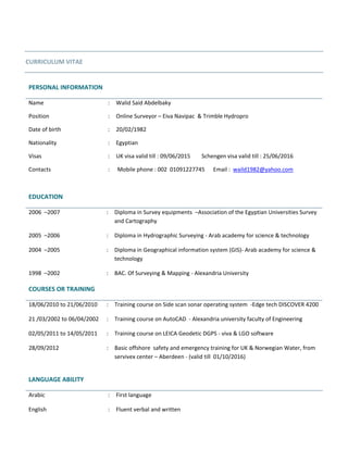
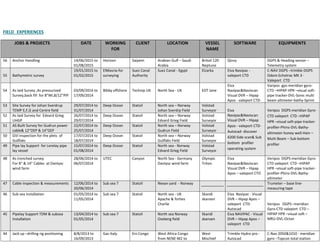
Oil Detection among Ice and Snow_Lessons learned_Sassi_Rytkönen 24 March 2015
C.V - Walid Abdelbaky
1. CURRICULUM VITAE
PERSONAL INFORMATION
Name : Walid Said Abdelbaky
Position : Online Surveyor – Eiva Navipac & Trimble Hydropro
Date of birth : 20/02/1982
Nationality : Egyptian
Visas : UK visa valid till : 09/06/2015 Schengen visa valid till : 25/06/2016
Contacts : Mobile phone : 002 01091227745 Email : waild1982@yahoo.com
EDUCATION
2006 –2007 : Diploma in Survey equipments –Association of the Egyptian Universities Survey
and Cartography
2005 –2006 : Diploma in Hydrographic Surveying - Arab academy for science & technology
2004 –2005 : Diploma in Geographical information system (GIS)- Arab academy for science &
technology
1998 –2002 : BAC. Of Surveying & Mapping - Alexandria University
LANGUAGE ABILITY
Arabic : First language
English : Fluent verbal and written
COURSES OR TRAINING
18/06/2010 to 21/06/2010 : Training course on Side scan sonar operating system -Edge tech DISCOVER 4200
21 /03/2002 to 06/04/2002 : Training course on AutoCAD - Alexandria university faculty of Engineering
02/05/2011 to 14/05/2011 : Training course on LEICA Geodetic DGPS - viva & LGO software
28/09/2012 : Basic offshore safety and emergency training for UK & Norwegian Water, from
servivex center – Aberdeen - (valid till 01/10/2016)
2. SOFTWARE SKILLS
Navigation- data acquisition : NAVIPAC -HYDROPRO -DISCOVER 4200 (SSS Edge tech software )
Data log express (Valeport Sound Velocity software ) - visual soft
Processing : Tide calc- Autodesk 2004-Autocad 2002 –Surfer-Nav edit (hydro pro processing).
GIS : Arc view – arc map – arc catalog.
CALIBRATIONS EXPERIENCED
(GYRO) sun shot, base line calibration& (DGPS) Transit fix calibration & (USBL) spin calibration
EQUIPMENTS BACKGROUND
citsuqaoeG Sub Bottom Profiler pinger & citsuqaoeG side scan & CODA & G-882 Marine Magnetometer pipe
tracker-profiler-Phins-DVL-Bathy-altimeter-Hain
WORK EXPERIENCES
-Working for (GOPS) Global offshore Petroleum Services Cyprus.(Online surveyor) From MAY 2012 till now
-Working for Saudi Arabia coast guards. (Online surveyor), (Side scan sonar operator) and (Single beam processor)
from January 2010 to March 2012.
-Working for Global offshore Petroleum Services Egypt, (Online surveyor) from August 2008 to December 2009
-Working for (SPS) Sub Sea Petroleum Services (Online surveyor) from March 2006 to August 2008
EQUIPMENTS EXPERIENCED
DGPS : Various DGPS systems
Echo sounder : Odom Echo track 3 – Odom CV 100 – Odom HT 100 - DESO 20 –RESON SEABAT
USBL System : Kongsberg HPR HIPAP 410
CTD : ValePort
Total station : Topcon GTS 236N
Telemetry system : SATEL
Side scan sonar : Edge tech 4200 multi pulse
3. FIELD EXPERIENCES
JOBS & PROJECTS DATE WORKING
FOR
CLIENT LOCATION VESSEL
NAME
SOFTWARE EQUIPMENTS
56 Anchor Handling 14/06/2015 to
01/08/2015
Horizon Saipem Arabian Gulf – Saudi
Arabia
Britoil 120
Neptune
Qinzy DGPS & Heading sensor –
Telemetry system
55 Bathymetric survey
19/01/2015 to
01/02/2015
ElMasria-for
surveying
Suez Canal
Authority
Suez Canal - Egypt Elzarka Eiva Navipac -
valeport CTD
C-NAV DGPS –trimble DGPS
Odom Echotrac MK 3 -
Valeport CTD
54 As laid Survey ,As pressurized
Survey,back fill for 8”WI,8/12”PIP
03/09/2014 to
17/09/2014
Bibby offshore Technip UK North Sea - UK EDT Jane
Eiva
Navipac&Naviscan
Visual DVR – Hipap
Apos - valeport CTD-
Varipos gps-meridian gyro-
CTD –HIPAP HPR –visual soft-
pipe tracker-DVL-Sonic multi
beam altimeter-bathy-Sprint
53 Site Survey for Johan Sverdrup
TEMP E,F,G and Centre field
29/07/2014 to
31/07/2014
Deep Ocean Statoil North sea – Norway
Johan Sverdrp Field
Volstad
Surveyor Eiva
Navipac&Naviscan
Visual DVR – Hipap
Apos - valeport CTD-
Autocad- discover
4200 Side scan& Sub
bottom profiler
operating system
Veripos DGPS-meridian Gyro-
CTD valeport CTD –HIPAP
HPR –visual soft-pipe tracker-
profiler-Phins-DVL-Bathy-
altimeter-honey well-Hain –
Multi Beam – Sub bottom
profiler
52 As laid Survey for Edvard Grieg
UHGP
26/07/2014 to
29/07/2014
Deep Ocean Statoil North sea – Norway
Edvard Grieg Field
Volstad
Surveyor
51 AS Built Survey for Gudrun power
cable& 12"OEP & 14"GEP
22/07/2014 to
25/07/2014
Deep Ocean Statoil North sea – Norway
Gudrun Field
Volstad
Surveyor
50 GVI inspection for the plets of
Gullfaks
17/07/2014 to
18/07/2014
Deep Ocean Statoil North sea – Norway
Gullfaks Field
Volstad
Surveyor
49 Pipe lay Support for Lorelay pipe
lay vessel
15/07/2014 to
01/08/2014
Deep Ocean Statoil North sea - Norway
Edvard Grieg Field
Volstad
Surveyor
48 As trenched survey
For 8" & 14" Cables at Dantysc
wind farm
28/06/2014 to
06/07/2014
UTEC Canyon North Sea - Germany
Dantysc wind farm
Olympic
Triton
Eiva
Navipac&Naviscan
Visual DVR – Hipap
Apos – valeport CTD
Veripos DGPS-meridian Gyro-
CTD valeport CTD –HIPAP
HPR –visual soft-pipe tracker-
profiler-Phins-DVL-Bathy-
altimeter
47 Cable inspection & measurements 12/06/2014 to
20/06/2014
Sub sea 7 Statoil Nexan yard - Norway Trumeter – base line-
measuring tape
46 Sub sea installation 01/05/2014 to
11/05/2014
Sub sea 7 Statoil North sea - UK
Apache & forties
Charlie
Skandi
skansen
Eiva Navipac - Visual
DVR – Hipap Apos –
valeport CTD-
Autocad
Veripos DGPS--meridian
Gyro-CTD valeport CTD –
HIPAP HPR –visual soft –
MRU-DVL-Octan
45 Pipelay Support TDM & subsea
installation
13/04/2014 to
01/05/2014
Sub sea 7 Statoil North sea Norway
Oseberg field
Skandi
skansen
Eiva NAVIPAC - Visual
DVR – Hipap Apos –
valeport CTD
44 Jack up –drilling rig positioning 8/8/2013 to
16/09/2013
Gas Italy Eni Congo West Africa Congo
from NENE-M2 to
West
Mischief
Trimble Hydro pro -
Autocad
C-Nav 2050&1010 - meridian
gyro –Topcon total station
4. NENE’-M3
JOBS & PROJECTS DATE WORKING
FOR
CLIENT LOCATION VESSEL
NAME
SOFTWARE EQUIPMENTS
43 Mattresses installation 11/7/2013 to
22/7/2013
Sub sea 7 Statoil North sea
Norway
Seven Viking Eiva NAVIPAC - Hipap
Apos- valeport CTD
C-nav DGPS- meridian gyro-
HIPAP- telemetry system satel
42 Saturation diving support 16/10/2012 to
15/11/2012
Andrews ISS North sea - UK Iremis
Atlantis
Eiva NAVIPAC-
Autocad
C-nav& Veripos DGPS-- –
meridian gyro-MRU motion
sensor HIPAP HPR
41 ROV & TUG Positioning during
cable laying
31/08/2012 to
27/09/2012
Andrews Technip
Norge
North sea - Norway
NJORD A
NJORD
platform
Eiva NAVIPAC C-NAV DGPS-- –meridian
gyro- telemetry system satel
40 Cable laying/Construction survey 8/07/2012 to
04/08/2012
Andrews Technip
Norge
North sea
Norway
Goliat field-trip 2
North Sea
Giant
Eiva NAVIPAC &
Visual DVR – Hipap
Apos – valeport CTD-
Autocad
Veripos DGPS---meridian
gyro-CTD valeport –HIPAP
HPR –visual soft
39 ROV &tug Positioning during
raisers installation
10/06/2012 to
25/06/2012
Andrews Technip
Norge
North sea Norway
NJORD Field
NJORD
platform
Eiva NAVIPAC-
Autocad
C-NAV DGPS-- –meridian
gyro- telemetry system satel
38 Semi-Submersible RIG MOVE 13/12/2011 to
21/12/2011
SAPESCO Gapco Mediterranean sea
Egypt
SCARAPEO 6 Eiva NAVIPAC Veripos DGPS-- ,meridian
gyro –satel telemetry system
37 Depri removal and air diving
support
25/11/2011 to
12/12/2011
Saudi Arabia –
Coast guards
Saudi Arabia
Government
Red sea Saudi Arabia
Obhor & megermah
jettys
Al zafer Trimble Hydro pro -
Autocad
C-NAV DGPS –trimble DGPS -
Odom HT 100 - valeport CTD
36 Wrecked objects survey- 18/7/2011 to
20/8/2011
Saudi Arabia –
Coast guards
Saudi Arabia
Government
Red sea Saudi Arabia
Obhor & megermah
jettys
Al zafer Trimble Hydro pro –
Autocad- discover
4200 Side scan
C-NAV DGPS –trimble DGPS
Odom HT 100 - valeport CTD
– Edge tech side scan sonar
35 Wrecked objects survey- 01/07/2011 to
09/07/2011
Saudi Arabia –
Coast guards
Saudi Arabia
Government
Red sea - Saudi Arabia
Jeddah port waiting
area & south entrance
15 m boat Trimble Hydro pro -
Autocad -discover
4200 Side scan
operating system
C-NAV DGPS –trimble DGPS
Odom HT 100 - valeport CTD
- Edge tech side scan sonar
34 Processing & Mapping 21/5/2011 to
03/06/2011
Saudi Arabia –
Coast guards
Saudi Arabia
Government
Saudi Arabia
Sheikh salman jetty
__________ Trimble Navi Edit –
Autocad-tide calc
_____________________
33 Wrecked objects survey 26/03/2011 to
15/04/2011
Saudi Arabia –
Coast guards
Saudi Arabia
Government
Red sea - Saudi Arabia
Jeddah port - north
entrance
15 m boat Trimble Hydro pro –
Autocad- discover
4200 Side scan
operating system
C-NAV DGPS –trimble DGPS
Odom HT 100 - valeport CTD
– Edge tech side scan sonar
32 Land survey - Processing &
mapping Almegermah-shaara
10/03/2011 to
19/03/2011
Saudi Arabia –
Coast guards
Saudi Arabia
Government
Red sea -Saudi Arabia
Almegermah-shaara
__________ Auto desk land 2004 Leica geodetic gps- Trimble
GPS - Topcon GTS 236N
31 Bathymetric survey 14/01/2011 to
07/02/2011
Saudi Arabia –
Coast guards
Saudi Arabia
Government
Red sea - Saudi Arabia
Altafia coast guards
jetty
Zodiac Trimble Hydro pro -
Autocad
C-NAV DGPS –trimble DGPS –
fluxgate gyro Odom HT 100 -
valeport CTD
5. JOBS & PROJECTS DATE WORKING
FOR
CLIENT LOCATION VESSEL
NAME
SOFTWARE EQUIPMENTS
30 Anchor Handling 05/12/2010 to
26/12/2010
SAPESCO Gapco Red sea - Egypt-
Gapco fields gulf of suez
maridive 55 Eiva NAVIPAC Veripos DGPS ,merdian gyro
29 Wrecked vessels survey 02/09/2010 to
23/09/2010
Saudi Arabia –
Coast guards
Saudi Arabia
Government
Red sea - Saudi Arabia-
Jeddah jetty
15 m boat Trimble Hydro pro -
discover 4200 Side
scan operating
system
C-NAV DGPS –trimble DGPS
Odom HT 100 - valeport CTD
- Edge tech side scan sonar
28 Air diving support for Debris
removal
16/07/2010 to
24/07/2010
Saudi Arabia –
Coast guards
Saudi Arabia
Government
Red sea - Saudi Arabia
Rabegh jetty
25 m boat Trimble Hydro pro C-NAV DGPS –trimble DGPS -
Meridian gyro
27 Processing & Mapping
For Jeddah port project
25/06/2010 to
10/07/2010
Saudi Arabia –
Coast guards
Saudi Arabia
Government
Red sea - Saudi Arabia
Jeddah port
__________ Trimble Navi Edit-
Auto desk land- Tide
________________________
26 Shallow water
Bathymetric survey
18/05/2010 to
12/06/2010
Saudi Arabia –
Coast guards
Saudi Arabia
Government
Red sea - Saudi Arabia
Jeddah port reef area
Zodiac Trimble Hydro pro C-NAV DGPS –trimble DGPS –
fluxgate gyro Odom HT 100 -
Vallyport SVP
25 Shallow water
Bathymetric survey
22/04/2010 to
15/5/2010
Saudi Arabia –
Coast guards
Saudi Arabia
Government
Red sea - Saudi Arabia
Jeddah port south
sector
Zodiac Trimble Hydro pro C-NAV DGPS –trimble DGPS –
fluxgate gyro - Odom HT 100
- valeport CTD
24 Bathymetric survey 09/03/2010 to
16/04/2010
Saudi Arabia –
Coast guards
Saudi Arabia
Government
Red sea - Saudi Arabia
Jeddah port north
sector (Deep water)
25 m boat Trimble Hydro pro C-NAV DGPS –trimble DGPS
Odom HT 100 - Valeport CTD
23 Bathymetric survey 19/02/2010 to
05/03/2010
Saudi Arabia –
Coast guards
Saudi Arabia
Government
Red sea - Saudi Arabia
Jeddah port south
sector
(Deep water)
25 m boat Trimble Hydro pro C-NAV DGPS –trimble DGPS
Odom HT 100 - Valeport CTD
22 Land Survey
Coast line mapping
15/01/2010 to
21/01/2010
Saudi Arabia –
Coast guards
Saudi Arabia
Government
Red sea - Saudi Arabia
Jeddah port (onshore)
_________ Auto desk land trimble DGPS-topcon total
station
21 DRILLSHIP MOVE 11/11/2009 to
21/11/2009
TRIEDENT Oil exco Mediterranean sea -
Libya
SONGA
SATURN
Trimble Hydro pro Tridas -Merdian gyro – C-NAV
DGPS
20 Pre-lay survey & Grap Sampling 10/09/2009 to
25/09/2009
ElMasria-for
surveying
TYCO Red sea EGYPT
ZAFRANAA
15 m boat Eiva NAVIPAC C-NAV DGPS –Meridian Gyro -
Echo track 3-Edge tech Side
scan-Pomer
19 DRILLSHIP MOVE 19/05/2009 to
26/05/2009
TRIEDENT Oil exco Mediterranean sea -
Libya
SONGA
SATURN
Trimble Hydro pro Tridas -Merdian gyro – C-NAV
DGPS-telemetry system
18 Semi-Submersible RIG MOVE 26/10/2008 to
7/11/2008
TRIEDENT Oil exco North sea UK OCEAN
GUARDIAN
Trimble Hydro pro Tridas -Merdian gyro – C-NAV
DGPS
6. JOBS & PROJECTS DATE WORKING
FOR
CLIENT LOCATION VESSEL
NAME
SOFTWARE EQUIPMENTS
17 Construction Survey 14/06/2008 to
28/06/2008
SUBSEA/PMS Aramco Arabian Gulf – Saudi
Arabia- MHRH Field ,
16" Flow Line from
MHRH 24 to MNTP-8
Alex
challenger
Eiva
Navipac&Naviscan
CSI DGPS & C-NAV DGPS –
Meridian Gyro- echotrack3 –
heave sensor-Geo acoustic
side scan sonar& Geo acoustic
pinger - Coda -
882Magnetometer- Valeport
CTD -hipap 410 HPR- Reson
sea bat multibeam-OCTAN
motion sensor
16 Construction Survey 08/06/2008 to
14/06/2008
SUBSEA/PMS Aramco Arabian Gulf – Saudi
Arabia- MRJN field 16"
Flow Line from MRJN
240/249 to MNTP-4
Alex
challenger
Eiva
Navipac&Naviscan
15 Construction Survey 29/05/2008 to
08/06/2008
SUBSEA/PMS Aramco Arabian Gulf – Saudi
Arabia- Zulf field 16"
Flow Line from ZULF
380/388 to ZULF TP-6
Alex
challenger
Eiva
Navipac&Naviscan
14 Construction Survey 08/05/2008 to
29/05/2008
SUBSEA/PMS Aramco Arabian Gulf – Saudi
Arabia- SFNY field
Alex
challenger
Eiva
Navipac&Naviscan
13 Land Survey -Mapping coast line -
wellhead positioning
15/04/2008 to
18/04/2008
SUBSEA SUCO Egypt-Suco onshore
fields
Ghareb
__________ ________________ CSI DGPS – total station
Topcon
12 Air diving support to restore stuck
seismic cables
02/03/2008 to
09/04/2008
SUBSEA GRANT Red sea - Egypt-
Gulf of Suez
Engy-k Track maker Magellan GPS
11 Land Survey -Mapping coast line -
wellhead positioning
07/02/2008 to
11/02/2008
SUBSEA SUCO Egypt-Suco onshore
fields
Ras Fanar
_________ ________________ CSI DGPS – total station
Topcon
10 Geophysical survey 07/12/2007 to
24/12/2007
SUBSEA PMS Red sea - Egypt-Gulf of
Suez-24"Pipeline-
Corridor Area
Western
shore
Eiva NAVIPAC
CSI DGPS & C-NAV DGPS –
Meridian Gyro echotrack3 –
heave sensor-Geo acoustic
side scan sonar& Geo acoustic
pinger - Coda -
882Magnetometer- Valeport
CTD -Hipap 410 HPR
9 Geophysical survey 23/11/2007 to
07/12/2007
SUBSEA PMS Red sea - Egypt-Gulf of
Suez-8" pipeline
Corridor Area
Western
shore
Eiva NAVIPAC
8 Coring & Grap sampling 05/11/2007 to
23/11/2007
SUBSEA PMS Red sea - Egypt-Gulf of
Suez- AL Amal fields
Western
shore
Eiva NAVIPAC
7 Geophysical survey 22/10/2007 to
05/11/2007
SUBSEA PMS Red sea - Egypt-Gulf of
Suez- AL Amal fields 8"
pipeline-from Amal A
platform to Amal B
Western
shore
Eiva NAVIPAC
6 Geophysical survey 07/10/2007 to
22/10/2007
SUBSEA PMS Red sea - Egypt-Gulf of
Suez-24"Pipeline from
Amal (A) platform to
Western
shore
Eiva NAVIPAC
7. Shore
5 Pre-lay survey for 22" pipeline 02/03/2007 to
26/03/2007
SUBSEA PMS Mediterranean sea
Egypt Bruls field
Western
shore
Eiva NAVIPAC
JOBS & PROJECTS DATE WORKING
FOR
CLIENT LOCATION VESSEL
NAME
SOFTWARE EQUIPMENTS
4 Jack up –drilling rig positioning 03/01/2007 to
21/01/2007
SUBSEA LUKOIL Gulf of Suez –Egypt-
South of Geisum Islands
Global
sentafi-141
Eiva NAVIPAC CSI DGPS & C-NAV DGPS –
Meridian Gyro – telemetry
system Satel
3 Bathymetric survey
For SUCO channel
05/09/2006 to
14/09/2006
SUBSEA SUCO Gulf of Suez –Egypt
Suco channel
15 m boat Eiva NAVIPAC CSI DGPS – Meridian Gyro -
echotrack3 – heave sensor
2 Jack up –drilling rig positioning 29/07/2006 to
18/08/2006
SUBSEA LUKOIL Gulf of Suez-Egypt Global
sentafi-124
CSI DGPS – Meridian Gyro
1 Pre-lay Survey for 22" pipeline 13/07/2006 to
23/07/2006
SUBSEA PMS Mediterranean sea
Egypt
PMS 31 Eiva NAVIPAC CSI DGPS & C-NAV DGPS –
Meridian Gyro echotrack3 –
heave sensor-Geo acoustic
side scan sonar