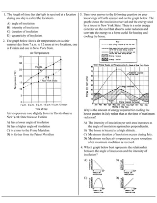
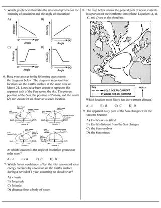
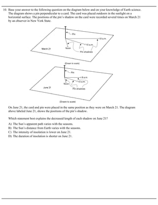
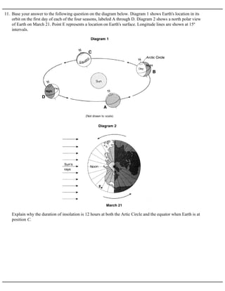
1. A) angle of insolation
B) intensity of insolation
C) duration of insolation
D) eccentricity of insolation
1. The length of time that daylight is received at a location
during one day is called the location's
2. The graph below shows air temperatures on a clear
summer day from 7 a.m. to 12 noon at two locations, one
in Florida and one in New York State.
A) has a lower angle of insolation
B) has a higher angle of insolation
C) is closer to the Prime Meridian
D) is farther from the Prime Meridian
Air temperature rose slightly faster in Florida than in
New York State because Florida
3. Base your answer to the following question on your
knowledge of Earth science and on the graph below. The
graph shows the insolation received and the energy used
by a house in New York State. There is a solar energy
collector on the roof that absorbs solar radiation and
converts the energy to a form useful for heating and
cooling the home.
A) The intensity of insolation per unit area increases as
the angle of insolation approaches perpendicular.
B) The house is located at a high altitude.
C) Maximum duration of insolation occurs during July.
D) Maximum surface air temperature occurs sometime
after maximum insolation is received.
Why is the amount of energy required for cooling the
house greatest in July rather than at the time of maximum
radiation?
A) B)
C) D)
4. Which graph below best represents the relationship
between the angle of insolation and the intensity of
insolation?
2. A) B)
C) D)
5. Which graph best illustrates the relationship between the
intensity of insolation and the angle of insolation?
6. Base your answer to the following question on
the diagrams below. The diagrams represent four
locations on the Earth's surface at the same time on
March 21. Lines have been drawn to represent the
apparent path of the Sun across the sky. The present
position of the Sun, the position of Polaris, and the zenith
(Z) are shown for an observer at each location.
A) A B) B C) C D) D
At which location is the angle of insolation greatest at
solar noon?
A) climate
B) longitude
C) latitude
D) distance from a body of water
7. Which factor would most affect the total amount of solar
energy received by a location on the Earth's surface
during a period of 1 year, assuming no cloud cover?
8. The map below shows the general path of ocean currents
in a portion of the Northern Hemisphere. Locations A, B,
C, and D are at the shoreline.
A) A B) B C) C D) D
Which location most likely has the warmest climate?
A) Earth's axis is tilted
B) Earth's distance from the Sun changes
C) the Sun revolves
D) the Sun rotates
9. The apparent daily path of the Sun changes with the
seasons because
3. 10. Base your answer to the following question on the diagram below and on your knowledge of Earth science.
The diagram shows a pin perpendicular to a card. The card was placed outdoors in the sunlight on a
horizontal surface. The positions of the pin’s shadow on the card were recorded several times on March 21
by an observer in New York State.
A) The Sun’s apparent path varies with the seasons.
B) The Sun’s distance from Earth varies with the seasons.
C) The intensity of insolation is lower on June 21.
D) The duration of insolation is shorter on June 21.
On June 21, the card and pin were placed in the same position as they were on March 21. The diagram
above labeled June 21, shows the positions of the pin’s shadow.
Which statement best explains the decreased length of each shadow on June 21?
4. 11. Base your answer to the following question on the diagram below. Diagram 1 shows Earth's location in its
orbit on the first day of each of the four seasons, labeled A through D. Diagram 2 shows a north polar view
of Earth on March 21. Point E represents a location on Earth's surface. Longitude lines are shown at 15º
intervals.
Explain why the duration of insolation is 12 hours at both the Artic Circle and the equator when Earth is at
position C.
5. Base your answers to questions 12 and 13 on the
diagram below, which represents an exaggerated view
of Earth revolving around the Sun. Letters A, B, C, and
D represent Earth's location in its orbit on the first day
of each of the four seasons.
A) A B) B C) C D) D
12. Which location in Earth’s orbit represents the first day
of fall (autumn) for an observer in Pennsylvania?
A) 1° per day B) 360° per day
C) 15° per hour D) 23.5° per hour
13. Earth’s rate of revolution around the Sun is
approximately
6. Base your answers to questions 14 and 15 on the
diagram below, which represents Earth revolving
around the Sun. Letters A, B, C, and D represent Earth's
location in its orbit on the first day of the four seasons.
NP represents the North Pole.
A)
B)
C)
D)
14. Which diagram best represents the Sun's apparent path
as seen by an observer at 43.5° N latitude on December
21?
A) A B) B C) C D) D
15. Which location in Earth's orbit represents the first day
of summer in New York State?
A) warm currents that flow northeastward
B) warm currents that flow southwestward
C) cool currents that flow northeastward
D) cool currents that flow southwestward
16. The Florida and Gulf Stream ocean currents along the
east coast of North America are both
A) rotation of the Earth
B) revolution of the Earth
C) unequal heating of the Earth
D) variations in salinity of the Earth's oceans
17. Ocean currents exhibit the Coriolis effect as a result of
the
A) variations in density of the water
B) variations in salinity of the water
C) planetary winds
D) land breezes and sea breezes
18. The direction of surface ocean currents is influenced
most by
A) atmospheric winds
B) atmospheric precipitation
C) ocean water evaporation
D) ocean floor earthquakes
19. The primary cause of surface ocean currents is
A) tides B) evaporation
C) prevailing winds D) salinity differences
20. Most surface ocean currents are caused by
A) the Moon spins on its axis
B) the Moon travels in an orbit around Earth
C) Earth spins on its axis
D) Earth travels in an orbit around the Sun
21. Surface ocean currents curve to the right in the
Northern Hemisphere because
A) cooling of rising air above the ocean surface
B) evaporation of water from the ocean surface
C) friction from planetary winds on the ocean surface
D) seismic waves on the ocean surface
22. Which interaction between the atmosphere and the
hydrosphere causes most surface ocean currents?
7. 23. Base your answer to the following question on The
arrows labeled A through D on the map below show the
general paths of abandoned boats that have floated
across the Atlantic Ocean.
A) South Equatorial Gulf Stream Labrador
Benguela
B) South Equatorial Australia West Wind Drift
Peru
C) North Equatorial Koroshio North Pacific
California
D) North Equatorial Gulf Stream North
Atlantic Canaries
Which sequence of ocean currents was responsible for
the movement of these boats?
A) wind B) gravity
C) tides D) pollution
24. What is the most direct cause of major surface ocean
currents?