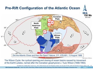
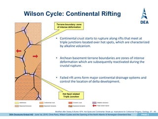
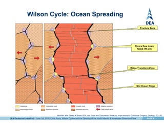
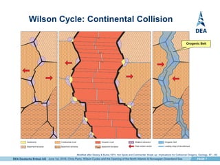
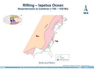
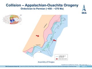
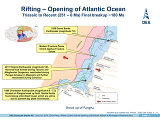
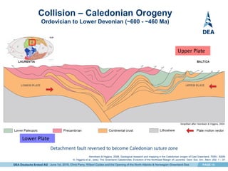
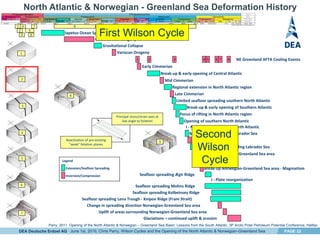
1) The document discusses the Wilson Cycle of plate tectonics as it relates to the opening of the North Atlantic and Norwegian-Greenland Sea. It describes the stages of continental rifting, ocean spreading, and continental collision over multiple cycles from the Precambrian to present.
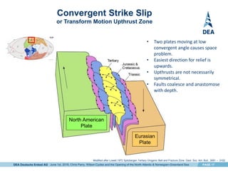
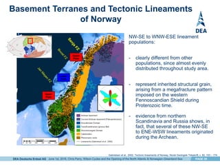
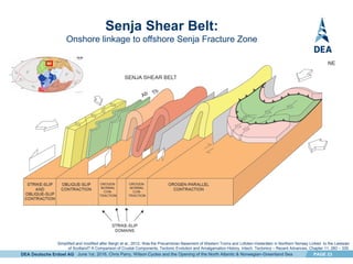
2) Fracture zones that formed during earlier tectonic phases were reactivated and controlled sediment entry points, hydrocarbon migration, and structural traps during the breakup of Pangea and opening of the North and Norwegian-Greenland Seas.
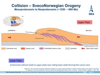
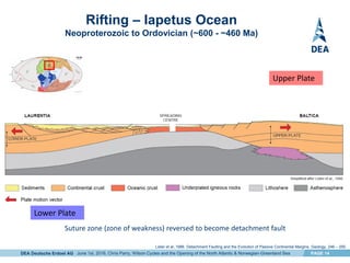
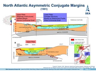
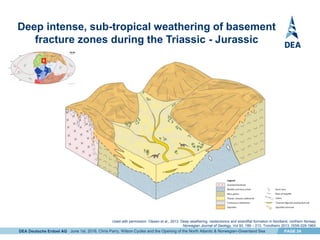
3) Asymmetric continental margins developed along Greenland and Norway, with the Greenland margin exhibiting more complex structure and a wider continental shelf as the lower plate during rift
sedimentary basin may be defined as an area of depression in the earth’s crust in which sediments accumulate during a particular time span at a significantly greater rate, and so to a significantly greater thickness.
The San Sai oil field is an important oil field in the Fang Basin. The sedimentary facies and basin
evolution have been interpreted using well data incorporated with 2D seismic profiles. The study indicates that
the Fang Basin was subsided as a half-graben in the Late Eocene by regional plate tectonism. The deposit is
thicker westward toward the major fault. The sedimentary sequence of the Fang Basin can be subdivided into
two formations which comprise five associated depositional environments. The results of total organic carbon
content (TOC), vitrinnite reflectance (%Ro), Rock-Eval pyrolysis and headspace gas analyses and the study of
basin modeling using PetroMod1D software are compiled and interpreted. They indicate that source rocks of
kerogen type II and III with 1.78 – 3.13%wt. TOC were mature and generated mainly oil at 5,600 – 6,700 feet
deep (Middle Mae Sod Formation). Source rocks of kerogen type II and III with 2.07 – 39.07%wt. TOC
locating deeper than 6,700 feet (Lower Mae Sod Formation) were mature to late mature and generated mainly
gas at this level. According to TTI (Time Temperature Index) modeling using PetroMod11.1D software,
hydrocarbon generation took place in the Middle Miocene and the generated oil and gas migrated through
fractures and faults to accumulate in traps at 2,900-4,000 feet deep (Upper Mae Sod Formation).
Sedimentary basins are the depressions in the earth's crust where loose particles accumulate and finally lithified to form sedimentary rocks. Basins are particularly attractive to geoscientists from time immemorial due to the wealth hidden here in the form of oil, gas, coal etc. In this document you will find the types of basins, basin-fill types, methods of basin analysis and so on.
The Chilcotin Basalts: implications for mineral explorationGraham Andrews
This is a presentation I gave at the GSA Cordilleran Meeting in Kelowna, BC, in May 2009. It presents advanced results from geological studies of the Chilcotin Group basalts in south-central BC, and their impact on mineral exploration activities.
A "spare wheel" talk* on the occasion of JK2018, the International Symposium around the Jurassic - Cretaceous Boundary
*: to replace a talk of a registered speaker who could not attend the meeting
Steps to Plate TectonicsStep 1 – Continental Driftwww.mat.docxdessiechisomjj4
Steps to Plate Tectonics:
Step 1 – Continental Drift
www.math.montana.edu / ~nmp / materials / ess / geosphere / inter / activities / plate_calc / pangaea_map.gif
The Continental Drift hypothesis published by Alfred Wegener in his 1915 book “ The Origin of Continents and Oceans”, although this was partially based on the work of earlier investigators.
Continental Drift = the continents were once connected in a single supercontinent called Pangaea. They have since drifted apart and are still moving today.
http://www.kidsgeo.com/geology-for-kids/0042-pangaea.php
Wegener’s hypothesis had several problems:
1) He had no power source – no way to make the continents move.
2) He thought the continents moved through the seafloor just like boats move through the ocean, but there was no evidence of this (no wake)
3) He was a meteorologist so many geologists didn’t take him seriously!
BUT Wegener had lots of evidence to show that the continents were once connected!
1) The jigsaw puzzle-like fit of the continents.
Figure 2.3 in text
Identical fossil assemblages on now widely spaced continents!
best about 250-200 MY ago
become increasingly dissimilar the closer to today we look!
Garrison, 2012, Essentials of Oceanography
3) Sequences of similar rock types on continents which do not now have the same geologic environment!
http://www.geology.ohio-state.edu/~vonfrese/gs100/lect25/index.html
4) Geologic structures (mountain ranges, faults, chains of volcanoes) which match up on either side of oceans but can not be found underwater.
5) Apparent polar wander – paleoclimatic evidence the continents had very different climates 250 MY ago than they do today.
either the continents moved or
the climate bands moved – which means the Earth’s poles of rotation moved.
Earth’s climate zones today are arranged symmetrically around the poles.
http://www.webquest.hawaii.edu/kahihi/sciencedictionary/C/climatezone.php
Paleoclimatic data from ˶300 MY ago, figure 2.5 in text
After Wegener died, his ideas were largely dismissed, until…
Post-Wegener evidence for drifting continents (and plate tectonics)…
6) Apparent Polar Wander – Paleomagnetic evidence.
Figure 2.7 showing that the Earth has a magnetic field very similar to that created by a bar magnet.
Directions of magnets parallel to Earth’s magnetic field lines.
Post-Wegener evidence for drifting continents (and plate tectonics)…
Figure 2.7b showing how magnets align to the Earth’s magnetic field when allowed to move freely.
Rocks containing the mineral magnetite (especially basalt) record the orientation of the Earth’s magnetic field at the time the rocks formed.
Figure 2.8a showing apparent polar wander paths for Europe and North America.
Figure 2.8b showing alignment of polar wander curves if the Atlantic Ocean is “closed”
The polar wander tracks for all the continents show great variation, suggesting it is the continents that moved!
If we put the continents “back to.
From the Arctic to the Tropics: The U.S. UNCLOS Bathymetric Mapping ProgramLarry Mayer
Since CHC2006, the University of New Hampshire’s Center for Coastal & Ocean Mapping/Joint Hydrographic Center has mapped with multibeam, the bathymetry of an additional ~220,000 km2 of seafloor in areas as diverse as the Arctic, the Northern Marianas of the western Pacific and the Gulf of Mexico. The mapping supports any potential U.S. submission for of extended continental shelves under Article 76 of the United Nations Convention of the Law of the Sea. Consequently, the mapping has concentrated on capturing the complete extent of the 2500-m isobath and the zone where the Article 76-defined foot of the slope exists. In practice, the complete area between ~1500 and ~4500 m water depths is mapped in each region (with the exception of the Arctic Ocean). The data have been collected in conditions that range from harsh Arctic sea ice to the calms of the Philippine Sea tropics. Although, some of the conditions have limited the quality of some of the data, the data quality is generally quite good and geological surprises have been uncovered on each of the cruises.
Plate Tectonics
Chapter 19
Plate TectonicsPlate tectonics - Earth’s surface composed thick plates that moveIntense geologic activity is concentrated at plate boundariesCombination of continental drift and seafloor spreading hypotheses proposed in late 1960s
Review: Three Types of Plate Boundaries
But how do we
know that plates
move at all ?
Transform Convergent Divergent
(strike-slip) (subduction) (spreading)
Early Case for Continental DriftPuzzle-piece fit of coastlines of Africa and South America has long been known
In early 1900s, Alfred Wegner noted South America, Africa, India, Antarctica, and Australia have almost identical rocks and fossils
Early Case for Continental DriftGlossopteris (plant), Lystrosaurus and Cynognathus (animals) fossils found on all five continents Mesosaurus (reptile) fossils found in Brazil and South Africa only
Glaciers Most of the Earth's ice is found in Antarctic continental glacier. Where are some other continental glaciers ?
FIGURE 10.5 Iceberg calving at Wrangell-St. Elias National Park, Alaska. Calving occurs when huge blocks of ice break off at the edge of a glacier that has moved to a shoreline. [Tom Bean.]
Glacial striations on a rock from stones grinding at the base of a heavy ice sheet leave these shiny linear marks on the bedrock below.
FIGURE 10.18 Glacial striations on bedrock in Glacier Bay National Park, Alaska. Striations are evidence of the direction of ice movement and are especially important clues for reconstructing the movement of continental glaciers. [Carr Clifton.]
Glacial Characteristics Glaciers flow downhill as a solid mass that creates channels, and walls made of ground up rock debris known as a merraine.
Erosional LandscapesErosional landforms produced by valley glaciers include: U-shaped valleys Hanging valleysSmaller tributary glacial valleys left stranded above more quickly eroded central valleys
Early Case for Continental DriftWegner reassembled continents into the supercontinent Pangaea
Late Paleozoic glaciation patterns on southern continents best explained by their reconstruction into (Pangaea) Gondwanaland
Early Case for Continental DriftCoal beds of North America and Europe indicate Laurasia super continent
Continental Drift hypothesis initially rejected Wegener could not come up with viable driving force continents should not be able to “plow through” sea floor rocks
The Earth's Magnetic Field
Can Give Us Clues
Paleomagnetism and Continental Drift RevivedStudies of rock magnetism allowed determination of magnetic pole locations (close to geographic poles) Paleomagnetism uses mineral magnetic alignment and dip angle to determine the distance to the magnetic pole when rocks formedSteeper dip angles indicate rocks formed closer .
A large impact crater beneath Hiawatha Glacier in northwest GreenlandSérgio Sacani
We report the discovery of a large impact crater beneath Hiawatha Glacier in northwest Greenland. From airborne radar surveys, we identify a 31-kilometer-wide, circular bedrock depression beneath up to a kilometer of ice. This depression has an elevated rim that cross-cuts tributary subglacial channels and a subdued central uplift that appears to be actively eroding. From ground investigations of the deglaciated foreland, we identify overprinted structures within Precambrian bedrock along the ice margin that strike tangent to the subglacial rim. Glaciofluvial sediment from the largest river draining the crater contains shocked quartz and other impact- related grains. Geochemical analysis of this sediment indicates that the impactor was a fractionated iron aster- oid, which must have been more than a kilometer wide to produce the identified crater. Radiostratigraphy of the ice in the crater shows that the Holocene ice is continuous and conformable, but all deeper and older ice appears to be debris rich or heavily disturbed. The age of this impact crater is presently unknown, but from our geological and geophysical evidence, we conclude that it is unlikely to predate the Pleistocene inception of the Greenland Ice Sheet.
1. Wilson Cycles and the Opening of the North
Atlantic & Norwegian – Greenland Sea
Chris Parry DEA Norge AS
EAGE, Vienna, June 1st, 2016
2. DEA Deutsche Erdoel AG PAGE 2
- The Wilson Cycle: Continental Rifting, Ocean Spreading, Continental Collision.
- North Atlantic – Eastern Seaboard USA: Tectonic Inheritance, Onshore/Offshore Fracture Zone
Linkage.
- Norwegian-Greenland Sea Asymmetric Conjugate Margins: Upper/Lower Plate Polarity, Fracture
Zones.
- Onshore/Offshore Fracture Zone Linkage
- Interplay between Structure and Sedimentation
Conclusions
Key Message
Fracture Zones control:
Coarse clastic sediment entry points (source to sink),
Provide hydrocarbon migration routes,
Create structural trapping geometries and
Allow for the development of new models for exploration
June 1st, 2016, Chris Parry, Wilson Cycles and the Opening of the North Atlantic & Norwegian-Greenland Sea
Presentation Outline
3. DEA Deutsche Erdoel AG PAGE 3
Pre-Rift Configuration of the Atlantic Ocean
African
Plate
North
American
Plate
Eurasian
Plate
The Wilson Cycle: the cyclical opening and closing of ocean basins caused by movement
of the Earth's plates, named after the Canadian geophysicist J. Tuzo Wilson (1908-1993)
1
2
3
Simplified and modified after Torsvik et al., 2010, Plate tectonics and net lithosphere rotation over the past 150 My. Earth and Planetary Science Letters, 106 – 112.
June 1st, 2016, Chris Parry, Wilson Cycles and the Opening of the North Atlantic & Norwegian-Greenland Sea
Did the Atlantic Close and then Re-Open? Nature, 211, 676-681, 13 August 1966
4
4. DEA Deutsche Erdoel AG PAGE 4
Continental Crust Accretion
Mesoarchean to Paleoproterozoic (~2890 - <1970 Ma)
Amalgamation of many smaller Archean terranes to form the earliest supercontinent
Bergh et al., 2012. Was the Precambrian Basement of Western Troms and Lofoten-Vesterålen in Northern Norway Linked to the Lewisian of Scotland?
A Comparison of Crustal Components, Tectonic Evolution and Amalgamation History. Intech. Tectonics – Recent Advances, Chapter 11, 283 – 330.
Lower Plate
Upper Plate
June 1st, 2016, Chris Parry, Wilson Cycles and the Opening of the North Atlantic & Norwegian-Greenland Sea
5. DEA Deutsche Erdoel AG PAGE 5
Wilson Cycle: Continental Rifting
Hot Spot related
Triple Junction
Terrane boundary: zone
of intense deformation
• Continental crust starts to rupture along rifts that meet at
triple junctions located over hot spots, which are characterized
by alkaline volcanism.
• Archean basement terrane boundaries are zones of intense
deformation which are subsequently reactivated during the
crustal rupture.
• Failed rift arms form major continental drainage systems and
control the location of delta development.
Modified after Dewey & Burke,1974, Hot Spots and Continental Break-up: Implications for Collisional Orogeny. Geology, 57 – 60.
June 1st, 2016, Chris Parry, Wilson Cycles and the Opening of the North Atlantic & Norwegian-Greenland Sea
6. DEA Deutsche Erdoel AG PAGE 6
Wilson Cycle: Ocean Spreading
Rivers flow down
failed rift arm
Mid Ocean Ridge
Ridge Transform Zone
Fracture Zone
June 1st, 2016, Chris Parry, Wilson Cycles and the Opening of the North Atlantic & Norwegian-Greenland Sea
Modified after Dewey & Burke,1974, Hot Spots and Continental Break-up: Implications for Collisional Orogeny. Geology, 57 – 60.
7. DEA Deutsche Erdoel AG PAGE 7
Wilson Cycle: Continental Collision
Orogenic Belt
June 1st, 2016, Chris Parry, Wilson Cycles and the Opening of the North Atlantic & Norwegian-Greenland Sea
Modified after Dewey & Burke,1974, Hot Spots and Continental Break-up: Implications for Collisional Orogeny. Geology, 57 – 60.
8. DEA Deutsche Erdoel AG PAGE 8
Collision – Grenville Orogeny
Mesoproterozoic (~1250 – 980 Ma)
Assembly of Rodina
Simplified and modified from Thomas, 2006, GSA Today, 4 – 11.
1
June 1st, 2016, Chris Parry, Wilson Cycles and the Opening of the North Atlantic & Norwegian-Greenland Sea
9. DEA Deutsche Erdoel AG PAGE 9
Rifting – Iapetus Ocean
Neoproterozoic to Cambrian (~760 - ~530 Ma)
1
Break up of Rodina
June 1st, 2016, Chris Parry, Wilson Cycles and the Opening of the North Atlantic & Norwegian-Greenland Sea
Simplified and modified from Thomas, 2006, GSA Today, 4 – 11.
10. DEA Deutsche Erdoel AG PAGE 10
Collision – Appalachian-Ouachita Orogeny
Ordovician to Permian (~450 - ~270 Ma)
Assembly of Pangea
1
June 1st, 2016, Chris Parry, Wilson Cycles and the Opening of the North Atlantic & Norwegian-Greenland Sea
Simplified and modified from Thomas, 2006, GSA Today, 4 – 11.
11. DEA Deutsche Erdoel AG PAGE 11
Rifting – Opening of Atlantic Ocean
Triassic to Recent (251 – 0 Ma) Final breakup ~180 Ma
Modern Fracture Zones
inherit Iapetus Fracture
Zones
1889 Charleston Earthquake (magnitude 6.6 - 7.3)
located on Pangea break up fault. Similar faults
found along entire East Coast, which are active
due to present day plate movements.
1929 Grand Banks
Earthquake (magnitude 7.2)
2011 Virginia Earthquake (magnitude 5.8).
Reverse fault formed during Taconic and
Alleghenian Orogenies, reactivated during
Pangea breakup in Mesozoic and further
reactivated during Cenozoic
1
Break up of Pangea
June 1st, 2016, Chris Parry, Wilson Cycles and the Opening of the North Atlantic & Norwegian-Greenland Sea
Simplified and modified from Thomas, 2006, GSA Today, 4 – 11.
12. DEA Deutsche Erdoel AG PAGE 12
Continental Crust Accretion
Mesoarchean to Paleoproterozoic (~2890 - <1970 Ma)
Amalgamation of many smaller Archean terranes to form the earliest supercontinent
Bergh et al., 2012. Was the Precambrian Basement of Western Troms and Lofoten-Vesterålen in Northern Norway Linked to the Lewisian of Scotland?
A Comparison of Crustal Components, Tectonic Evolution and Amalgamation History. Intech. Tectonics – Recent Advances, Chapter 11, 283 – 330.
2
Lower Plate
Upper Plate
June 1st, 2016, Chris Parry, Wilson Cycles and the Opening of the North Atlantic & Norwegian-Greenland Sea
13. DEA Deutsche Erdoel AG PAGE 13
Continental collision leads to upper plate over-riding lower plate forming the suture zone
Collision – SvecoNorwegian Orogeny
Mesoproterozoic to Neoproterozoic (~1250 - ~960 Ma)
2
Lower Plate
Upper Plate
June 1st, 2016, Chris Parry, Wilson Cycles and the Opening of the North Atlantic & Norwegian-Greenland Sea
Bergh et al., 2012. Was the Precambrian Basement of Western Troms and Lofoten-Vesterålen in Northern Norway Linked to the Lewisian of Scotland?
A Comparison of Crustal Components, Tectonic Evolution and Amalgamation History. Intech. Tectonics – Recent Advances, Chapter 11, 283 – 330.
14. DEA Deutsche Erdoel AG PAGE 14
Suture zone (zone of weakness) reversed to become detachment fault
Rifting – Iapetus Ocean
Neoproterozoic to Ordovician (~600 - ~460 Ma)
2
Lister et al.,1986. Detachment Faulting and the Evolution of Passive Continental Margins. Geology, 246 – 250.
Lower Plate
Upper Plate
June 1st, 2016, Chris Parry, Wilson Cycles and the Opening of the North Atlantic & Norwegian-Greenland Sea
15. DEA Deutsche Erdoel AG PAGE 15
Detachment fault reversed to become Caledonian suture zone
Collision – Caledonian Orogeny
Ordovician to Lower Devonian (~600 - ~460 Ma)
2
Henriksen & Higgins, 2008, Geological research and mapping in the Caledonian orogen of East Greenland, 700N - 820N.
In: Higgins et al., (eds), The Greenland Caledonides: Evolution of the Northeast Margin of Laurentia. Geol. Soc. Am., Mem. 202, 1 – 27.
Lower Plate
Upper Plate
June 1st, 2016, Chris Parry, Wilson Cycles and the Opening of the North Atlantic & Norwegian-Greenland Sea
16. DEA Deutsche Erdoel AG PAGE 16
Rifting – Opening of Norwegian-Greenland Sea
Triassic to Recent (251 – 0Ma) Final breakup 56 Ma
2
Caledonian suture zone reversed to become detachment fault
Dinkelman et al., 2010, The NE Greenland Continental Margin. Geo Expro, December, 36 – 40.
Faleide et al., 2008, Structure and evolution of the continental margin off Norway and the Barents Sea. Episodes, 31, 82 – 91.
Lower Plate
Upper Plate
June 1st, 2016, Chris Parry, Wilson Cycles and the Opening of the North Atlantic & Norwegian-Greenland Sea
17. DEA Deutsche Erdoel AG PAGE 17
Convergent Strike Slip
or Transform Motion Upthrust Zone
3
Modified after Lowell,1972 Spitzbergen Tertiary Orogenic Belt and Fracture Zone. Geol. Soc. Am. Bull., 3091 – 3102.
Eurasian
Plate
North American
Plate
• Two plates moving at low
convergent angle causes space
problem.
• Easiest direction for relief is
upwards.
• Upthrusts are not necessarily
symmetrical.
• Faults coalesce and anastomose
with depth.
June 1st, 2016, Chris Parry, Wilson Cycles and the Opening of the North Atlantic & Norwegian-Greenland Sea
18. DEA Deutsche Erdoel AG PAGE 18
Detachment-Fault Model of Passive Continental Margins
Upper Plate or Lower Plate Characteristics
2 Complex Structure,
Bowed up Detachment Faults,
Wide Continental Shelf.
Lower Plate
Upper Plate
Relatively Unstructured,
Underplating Uplift,
Narrow Continental Shelf.
Lister et al.,1986. Detachment Faulting and the Evolution of Passive Continental Margins. Geology, 246 – 250.
June 1st, 2016, Chris Parry, Wilson Cycles and the Opening of the North Atlantic & Norwegian-Greenland Sea
19. DEA Deutsche Erdoel AG PAGE 19
North Atlantic Asymmetric Conjugate Margins
(1991)
Torske & Prestvik, 1991. Mesozoic detachment faulting between Greenland and Norway:
Inferences from Jan Mayen Fracture Zone system and associated alkalic volcanic rocks. Geology, 481 – 484.
Lower
PlateLower
Plate
Lower Plate:
Complex Structure,
Bowed up Detachment Faults,
Wide Continental Shelf.
Upper
Plate
Upper
Plate
Upper Plate
Upper Plate:
Relatively Unstructured,
Uplifted Margin,
Narrow Continental Shelf.
June 1st, 2016, Chris Parry, Wilson Cycles and the Opening of the North Atlantic & Norwegian-Greenland Sea
20. DEA Deutsche Erdoel AG PAGE 20
Basement Terranes and Tectonic Lineaments
of Norway
Lower
Plate
Upper
Plate
Upper
Plate
NW-SE to WNW-ESE lineament
populations:
- clearly different from other
populations, since almost evenly
distributed throughout study area.
- represent inherited structural grain,
arising from a megafracture pattern
imposed on the western
Fennoscandian Shield during
Proterozoic time.
- evidence from northern
Scandinavia and Russia shows, in
fact, that several of these NW-SE
to ENE-WSW lineaments originated
during the Archean.
Gabrielsen et al., 2002. Tectonic lineaments of Norway, Norsk Geologisk Tidsskrift, v. 82, 153 – 174.
June 1st, 2016, Chris Parry, Wilson Cycles and the Opening of the North Atlantic & Norwegian-Greenland Sea
21. DEA Deutsche Erdoel AG PAGE 21
Lewisian Gneiss Complex (UK) -
Offshore/Onshore Linkage
• Accreted as series of terranes in the
Precambrian
• Accretion occurred before most brittle
deformation
Pless et al., 2010. Characterising fault networks in the Lewisian Gneiss Complex,
NW Scotland: Implications for petroleum potential in the Clair Field basement, Faroe-Shetland Basin. AAPG, New Orleans – oral & poster presentation
• Prominent NE-SW & NW-SE fault trends
• NW-SE faults produce the longest lineaments
• Originate in Archean (2490-2400 Ma): Steep
NW-SE shear zones formed due to dextral
transpression
• Reactivated during all subsequent tectonic
episodes
June 1st, 2016, Chris Parry, Wilson Cycles and the Opening of the North Atlantic & Norwegian-Greenland Sea
22. DEA Deutsche Erdoel AG PAGE 22
North Atlantic & Norwegian - Greenland Sea Deformation History
1
2
3
4
5
7
1
2
3
4
5
6
7 8 9
6
Iapetus Ocean Spreading
Variscan Orogeny
1 2 3 4 5 6 7 8 NE Greenland AFTA Cooling Events
Break-up & early opening of Central Atlantic
Regional extension in North Atlantic region
Limited seafloor spreading southern North Atlantic
Focus of rifting in North Atlantic region
Opening of southern North Atlantic
I - Main rift axis northern North Atlantic
Main rift axis moved to Labrador Sea
Seafloor spreading Labrador Sea
Rifting in Norwegian-Greenland Sea area
Break-up Norwegian-Greenland Sea area - Magmatism
Seafloor spreading Ægir Ridge
I - Plate reorganization
Change in spreading direction Norwegian-Greenland Sea area
Uplift of areas surrounding Norwegian-Greenland Sea area
Glaciations – continued uplift & erosion
Seafloor spreading Kolbeinsey Ridge
Seafloor spreading Mohns Ridge
Seafloor spreading Lena Trough - Knipov Ridge (Fram Strait)
Break-up & early opening of Southern Atlantic
Caledonidian Orogeny
Gravitational Collapse
8
9
Principal stress/strain axes at
low angle to foliation
Reactivation of pre-existing
”weak” foliation planes
U Cretaceous Inversion
Early Cimmerian
Mid Cimmerian
Late Cimmerian
Laramide Orogeny
Extension/Seafloor Spreading
Inversion/Compression
Legend
June 1st, 2016, Chris Parry, Wilson Cycles and the Opening of the North Atlantic & Norwegian-Greenland Sea
First Wilson Cycle
Second
Wilson
Cycle
Parry, 2011. Opening of the North Atlantic & Norwegian – Greenland Sea Basin: Lessons from the South Atlantic. 3P Arctic Polar Petroleum Potential Conference, Halifax
23. DEA Deutsche Erdoel AG PAGE 23
Senja Shear Belt:
Onshore linkage to offshore Senja Fracture Zone
Simplified and modified after Bergh et al., 2012. Was the Precambrian Basement of Western Troms and Lofoten-Vesterålen in Northern Norway Linked to the Lewisian
of Scotland? A Comparison of Crustal Components, Tectonic Evolution and Amalgamation History. Intech. Tectonics – Recent Advances, Chapter 11, 283 – 330.
June 1st, 2016, Chris Parry, Wilson Cycles and the Opening of the North Atlantic & Norwegian-Greenland Sea
24. DEA Deutsche Erdoel AG PAGE 24
Deep intense, sub-tropical weathering of basement
fracture zones during the Triassic - Jurassic
Used with permission: Olesen et al., 2013. Deep weathering, neotectonics and strandflat formation in Nordland, northern Norway.
Norwegian Journal of Geology, Vol 93, 189 – 213. Trondheim 2013, ISSN 029-196X.
June 1st, 2016, Chris Parry, Wilson Cycles and the Opening of the North Atlantic & Norwegian-Greenland Sea
25. DEA Deutsche Erdoel AG PAGE 25
Basement fractures – sites of preferential weathering
re-used by Plio-Pleistocene to Recent glaciers
4
June 1st, 2016, Chris Parry, Wilson Cycles and the Opening of the North Atlantic & Norwegian-Greenland Sea
26. DEA Deutsche Erdoel AG PAGE 26
Conclusions
› Wilson Cycles and Tectonic Inheritance:
› Continental collision suture zone becomes detachment zone during subsequent rifting,
› Basement fractures have controlled the assembly and breakup of continents through
out geologic time,
› Reactivated most recently during post-glacial isostatic readjustment.
› Fracture Zones have been the sites of intensely weathered since their formation:
› Especially during the Triassic-Jurassic sub-tropical climates,
› Most recently used by Plio-Pleistocene - Recent glaciers,
› Cleaned out during the last ice age.
› Fracture Zones control:
› Sediment distribution,
› Coarse clastic entry points (source to sink),
› Provide hydrocarbon migration routes,
› Create trapping geometries (strike-slip faulting geometries) &
› Allow development of new models for exploration.
Acknowledgements:
DEA management for support for the publication of this article,
Roy Gabrielsen (UiO) and John Dehls (NGU) for use of the digital lineament dataset,
Odleiv Olesen (NGU) for permission to use Jurassic weathering diagram.
June 1st, 2016, Chris Parry, Wilson Cycles and the Opening of the North Atlantic & Norwegian-Greenland Sea