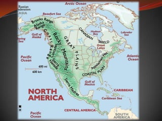
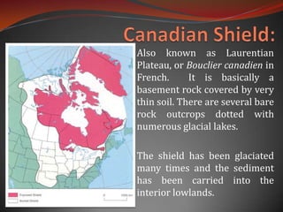
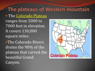
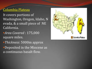
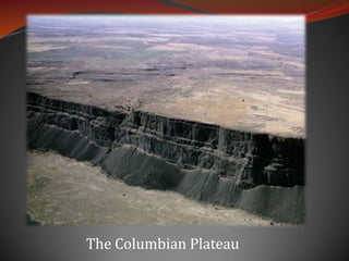
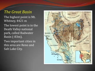
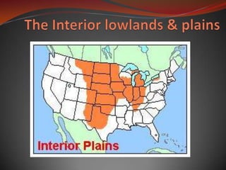
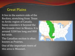
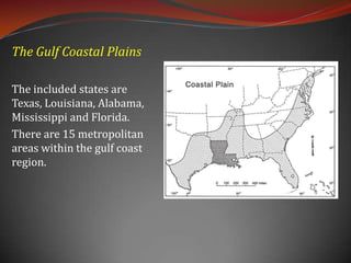
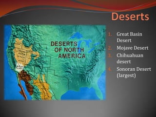
NORTH AMERICA
Physiography: The physiography of North America can be broadly classified into the following divisions:Canadian Shield
Eastern Mountains
Western Mountains
Interior Lowlands & Great Plain
Coastal Plains
Deserts
Canadian Shield:Also known as Laurentian Plateau, or Bouclier canadien in French.  It is basically a basement rock covered by very thin soil. There are several bare rock outcrops dotted with numerous glacial lakes. The shield has been glaciated many times and the sediment has been carried into the interior lowlands.
The soils in the states of Ohio, Indiana, Iowa, and Illinois are the transported materials from the Canadian shield.  The shield is primarily made up of metamorphic rocks. The shield was originally a region of very large mountains and some volcanic activity, but over the millennia the area was eroded. The glacial activity over here is quite pronounced and presently this area is covered  by coniferous trees.
The height of the shield ranges from 305m to 610m.There are a number of mountain ranges within the shield: the Adirondack (northeastern New York state), Superior Highlands (northern Minnesota, Wisconsin & Michigan states), Torngat and Laurentian.The shield is a rich source of metallic minerals such as iron, nickel, copper, zinc, uranium, gold, silver, platinum and molybdenum.
This is the highest point of the Canadian Shield Mount Caubvick (1652 m). It is situated in New Foundland.
The Eastern MountainsThe eastern mountain complex consist of the Appalachian Mountains. The Appalachians, are about 1,500 miles in length, and 480 km wide extending  from central Alabama in the U.S. up through the New England states and the Canadian provinces of New Brunswick, Newfoundland and Quebec. 
Significant Appalachian ranges include: The Cumberland Mts. in Tennessee
The Blue Ridge Mts. in Virginia
The Alleghenies in Pennsylvania
The Catskills Mts. in New York
The Green Mts. in Vermont
The White Mts. of New HampshireThe highest point is Mt. Mitchell in North Carolina at 6,684 ft (2,037 m) 
The Appalachians are the product tectonic collision. During the middle Ordovician Period (about 496-440 million years ago), a change in plate motions set the stage for the first Paleozoic mountain building event . There were four such tectonic movements which is believed to be responsible for the formation of Appalachian Mountains.At one time the mountains may have been 20,000 feet high. However, today the average height of the Appalachian mountains is 3000ft.Because of dense forests and rugged steep slopes  it acted as a barrier for the first 150 years of European settlement.
The western mountainsThe western mountain complex consists of mountains, plateaus & valleys.The whole complex can be divided into:The Rockies
Intermountain Plateaus
Pacific Mountains and valleys.RockiesThe Rocky Mountains stretch more than 3,000 miles(4,800 kilometers) from northernmost British Columbia, in Canada, to New Mexico, in the United States. The highest peak is Mount Elbert, in Colorado, which is 14,440 feet (4,401 meters) above sea level.
Topographically, the Rockies are usually divided into five sections: The Southern Rockies,
 The Middle Rockies,
 The Northern Rockies (all in the United States),
 The Rocky Mountain of Canada (Canadian Rockies)The highest point of Canadian Rockies is Mount Robson, 3954m. The Brooks Range in Alaska. * (Mt. Chamberlin 2749m)*(Many do not consider the Brooks Range to be part of the Rockies)The Wyoming Basin, the system's principal topographic break, is sometimes considered a sixth section.
The plateaus of Western mountain The Colorado Plateau ranges from 5000 to 7000 feet in elevation.  It covers 130,000 square miles.
The Colorado Rivers drains the 90% of the plateau that carved the beautiful Grand Canyon.The Grand Canyon:Length: 446 km

North america

  • 1.
  • 2.
    Physiography: The physiographyof North America can be broadly classified into the following divisions:Canadian Shield
  • 3.
  • 4.
  • 5.
  • 6.
  • 7.
  • 8.
    Canadian Shield:Also knownas Laurentian Plateau, or Bouclier canadien in French. It is basically a basement rock covered by very thin soil. There are several bare rock outcrops dotted with numerous glacial lakes. The shield has been glaciated many times and the sediment has been carried into the interior lowlands.
  • 9.
    The soils inthe states of Ohio, Indiana, Iowa, and Illinois are the transported materials from the Canadian shield. The shield is primarily made up of metamorphic rocks. The shield was originally a region of very large mountains and some volcanic activity, but over the millennia the area was eroded. The glacial activity over here is quite pronounced and presently this area is covered by coniferous trees.
  • 10.
    The height ofthe shield ranges from 305m to 610m.There are a number of mountain ranges within the shield: the Adirondack (northeastern New York state), Superior Highlands (northern Minnesota, Wisconsin & Michigan states), Torngat and Laurentian.The shield is a rich source of metallic minerals such as iron, nickel, copper, zinc, uranium, gold, silver, platinum and molybdenum.
  • 11.
    This is thehighest point of the Canadian Shield Mount Caubvick (1652 m). It is situated in New Foundland.
  • 12.
    The Eastern MountainsTheeastern mountain complex consist of the Appalachian Mountains. The Appalachians, are about 1,500 miles in length, and 480 km wide extending from central Alabama in the U.S. up through the New England states and the Canadian provinces of New Brunswick, Newfoundland and Quebec. 
  • 13.
    Significant Appalachian rangesinclude: The Cumberland Mts. in Tennessee
  • 14.
    The Blue RidgeMts. in Virginia
  • 15.
    The Alleghenies inPennsylvania
  • 16.
  • 17.
    The Green Mts.in Vermont
  • 18.
    The White Mts.of New HampshireThe highest point is Mt. Mitchell in North Carolina at 6,684 ft (2,037 m) 
  • 19.
    The Appalachians arethe product tectonic collision. During the middle Ordovician Period (about 496-440 million years ago), a change in plate motions set the stage for the first Paleozoic mountain building event . There were four such tectonic movements which is believed to be responsible for the formation of Appalachian Mountains.At one time the mountains may have been 20,000 feet high. However, today the average height of the Appalachian mountains is 3000ft.Because of dense forests and rugged steep slopes it acted as a barrier for the first 150 years of European settlement.
  • 20.
    The western mountainsThewestern mountain complex consists of mountains, plateaus & valleys.The whole complex can be divided into:The Rockies
  • 21.
  • 22.
    Pacific Mountains andvalleys.RockiesThe Rocky Mountains stretch more than 3,000 miles(4,800 kilometers) from northernmost British Columbia, in Canada, to New Mexico, in the United States. The highest peak is Mount Elbert, in Colorado, which is 14,440 feet (4,401 meters) above sea level.
  • 23.
    Topographically, the Rockiesare usually divided into five sections: The Southern Rockies,
  • 24.
    The MiddleRockies,
  • 25.
    The NorthernRockies (all in the United States),
  • 26.
    The RockyMountain of Canada (Canadian Rockies)The highest point of Canadian Rockies is Mount Robson, 3954m. The Brooks Range in Alaska. * (Mt. Chamberlin 2749m)*(Many do not consider the Brooks Range to be part of the Rockies)The Wyoming Basin, the system's principal topographic break, is sometimes considered a sixth section.
  • 27.
    The plateaus ofWestern mountain The Colorado Plateau ranges from 5000 to 7000 feet in elevation. It covers 130,000 square miles.
  • 28.
    The Colorado Riversdrains the 90% of the plateau that carved the beautiful Grand Canyon.The Grand Canyon:Length: 446 km