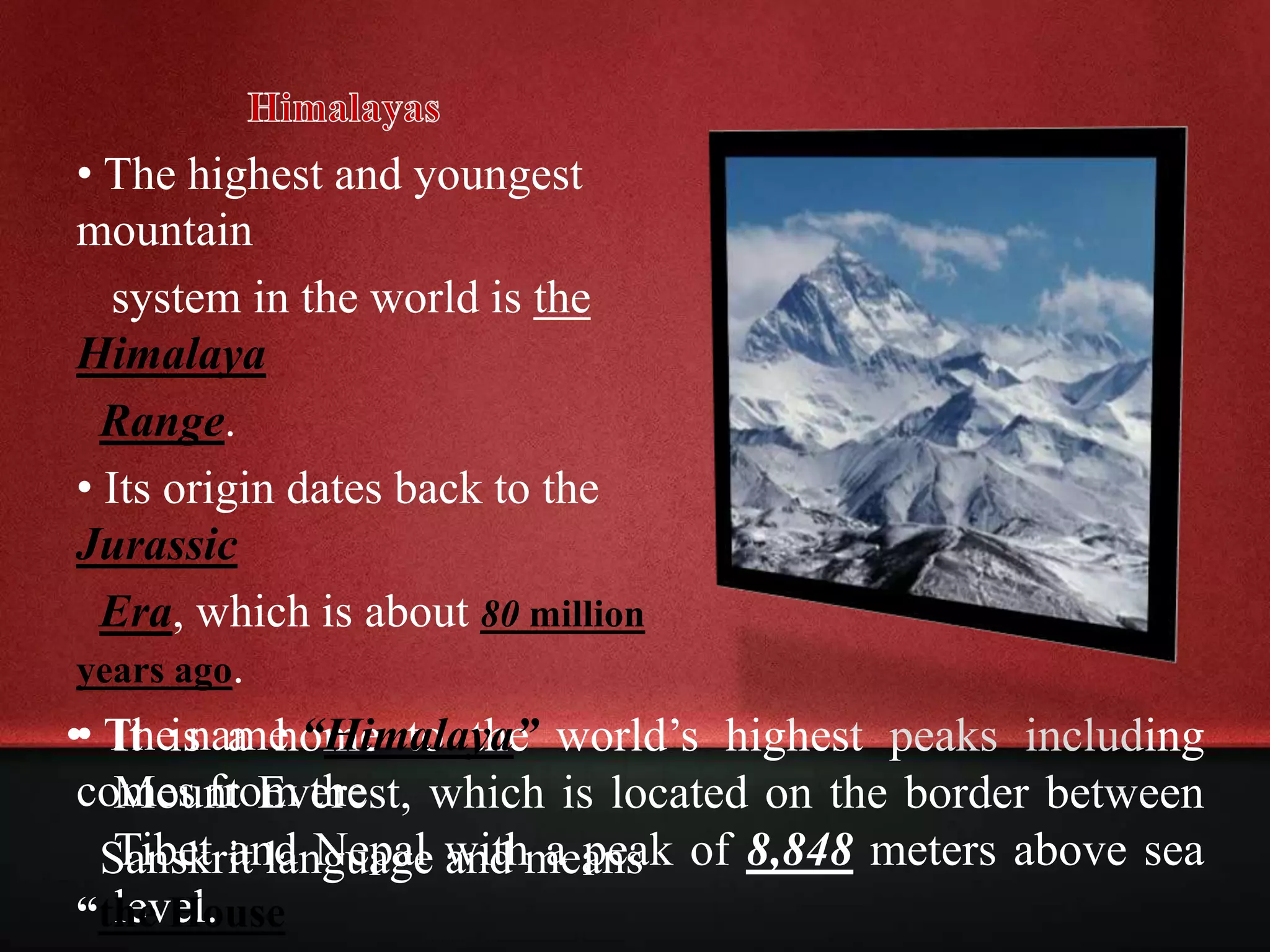
CHARACTERISTICS OF MAJOR MOUNTAIN RANGES
• A succession of many closely spaced mountains covering a particular
portion of Earth is called mountainrange.
• It consist of several valleys and river channels formed by water rushing
down from melting glacier or iceberg.
• Several mountain ranges that run roughly parallel to each other are
collectively termed as mountainbelts.
• Most mountain ranges are usually located either in the Pacific Ring of Fire
or the
• The or the Circum-Pacific Seismic Belt is a horseshoe-
shaped region in the Pacific Ocean basin that is characterized by a large
number of earthquakes and volcanic eruptions.
• It includes the Andes of South America, the North American Cordillera
along the Pacific Coast, the Aleutian Range, on through Kamchatka,
Japan, Taiwan, Philippines, Papua New Guinea, to New Zealand.
• The Alpide Belt is a mountain range that is being created by the ongoing
collision of plate tectonics between the northward-moving African,
Arabian and Indian plates, Eurasian plate, Indonesia and Southeast Asia
through the Himalaya and ends in the Alps.
• Other Asian and European mountain ranges are also found in Alpide
Belt.
• Mountain ranges outside of these two systems include the world’s
northernmost mountain range, the Arctic Cordillera, which extends
along the Canadian Arctic Archipelago from Ellesmere Island to the
northeasternmost part of the Labrador Peninsula in northern Labrador
and northern Quebec, Canada.
Generalization
All mountain ranges are composed of several peaks and
each of these peaks has its own physical feature. They share
the property of high altitude and hold a vast amount of
water in their areas. While the specific weather condition in
a specific mountain range depends on its location on Earth,
most of them are subject to drastic changes in temperature
and weather that happens from moment to moment. For
instance, a thunderstorm can suddenly roll in after few
minutes of sunny sky or a warm temperature can lower to
almost the water’s freezing point from an hour to the next.
Due to the rapid changes in weather inside these ranges,
many species of flora and fauna survive, which explains
why mountain ranges are home to the greatest regions of
biodiversity on the planet.
AlpAppalachian
Himalaya Andes
Great Dividing Range
• It is a home to the world’s highest peaks including
Mount Everest, which is located on the border between
Tibet and Nepal with a peak of 8,848 meters above sea
level.
• The highest and youngest
mountain
system in the world is the
Himalaya
Range.
• Its origin dates back to the
Jurassic
Era, which is about 80 million
years ago.
• The name “Himalaya”
comes from the
Sanskrit language and means
“the House
• It stretches along a curve covering a geographic
location from southern Asia from the Pamirs, west of the great
bend of the Indus River, eastward to the great bend of the
Brahmaputra River.
• The Himalaya Range forms a barrier which separates northern
India from the plateau of Tibet. Parts of the range are as much as
200 miles wide.
• The Himalaya Range records an elevation of about 1,000 ft. (305
m) above sea level, giving greater heights over the plains of
northern India.
• Because of the great difference in various parts of range, almost
every kind of climate can be found in the Himalaya.
• Many peaks of the Himalaya are regarded sacred in Hinduism
and Buddhism.
• Many Andean peaks rise over (6,096 m), hence, only the
Himalaya Mountains and their adjacent ranges such as the Hindu
Kush are higher than the Andes range.
• The Andes is divided into three sections: ,
, and .
• The is the
longest mountain chain in the
world.
• It stretch extend along the
entire west coast of South
America from Cape Horn to
Panama, a distance of
* Andes is a Mesozoic-Tertiary orogenic belt of mountain
along the Pacific Ring of Fire.
* They were created due to plate tectonic processes
caused by the compression of the western rim of the
South American Plate.
* Due to the subduction of the Nazca Plate and Antarctic
Plate, the landmass rose into great heights. Because of its
location, the Andes is a region for earthquake belts and
active volcanoes found in four volcanic zones.
• The mountains form the eastern continental divide between the
rivers that flow into the Atlantic Ocean and those that drain into
the Gulf of Mexico.
• The Appalachians formed during the Ordovician Period,
* The primary mountain system
of the eastern Northern America
are the Appalachians.
• It is known to be the oldest
mountains in the United States,
the Appalachian stretches
southwestward for about 1,500
miles from Quebec in Canada to
central Alabama.
• The range is composed of more than 40 peaks that
reach over 6,000 feet.
• Mount Mitchell in Northern Carolina is the highest peak
of the Appalachians, standing 6,684 feet.
• During its original orogenesis, the continents of Earth
were in different locations as what has been explained
by plate tectonics.
• The Appalachians were once an extension of the
Caledonian mountain chain, a chain that is today
located in Scotland and Scandinavia.
• Prior its period of erosion, Appalachian mountains have
reached elevations as high as those of the Alps and the
Rocky Mountains.
• The towering peaks of the Alps of approximately
and are covered with ice and snow are considered the most
magnificent natural sight in the continent.
• Towering at feet above sea level, the in
the Pennine Alps, France is the highest mountain in this
mountain range.
are the most largest
mountain system in Europe.
• They extend from the
southeastern France and
northern Italy, most of
Switzerland, part of southern
Germany, and some portion of
Austria and Yugoslavia.
• Alpinism or mountaineering is believed to have originated in
the Alps.
• Alpine orogeny was an episodic process started about 300
million years ago.
• During the Paleozoic Era, the Pangaea is the only continent
on Earth.
• It separated into 2 continents, Laurasia and Gondwanaland
during the Mesozoic Era.
• The 2 continents were separated by the Tethys Sea. However,
the sea was squeezed between colliding plates that formed
the mountain ranges called the Alpide belt.
• This belt covers Gibraltar, the Himalayas to Indonesia.
• The Alps were part of the orogenesis caused by the collision
between the Eurasian and African plates that dates back in
the late Cretaceous Period.
• Rockies or the Rocky Mountains are group of jagged, snow-
capped peaks which run through the western part of Northern
America.
• The Rockies include all uplands and mountains of New
Mexico, British Columbia, and north Alberta in Canada and
United States of America.
• The approximate length of this range is 6,035 kilometers.
• The mountains were formed from 80 million to 55 million years
ago during the Laramide orogeny, the period when a number of
plates began to slide underneath the North American Plate.
• Most of the peaks in this range were formed in a great upheavel of
Earth’s crust.
• Fossil skeletons of animals that are believed to once lived in the sea
and rocks that formed in the hot interior of Earth were found at the
sides of the mountains.
• Geysers of Yellowstone National Park and the huge lava sheets of
Idaho are evident signs that volcanism took place along the
Rockies.
• The mountains are also known for their minerals such as
gold, silver, lead, and copper, as well as coal, oil shale, and
phosphate rock.
• The highest peak is Mount Elbert, which stand 4,401 m. As
the range extends north through Alaska, the peaks gradually
become lower until they disappear in a series of ice-covered
hills at the Arctic Circle.
THE GREAT DIVIDING RANGE
- A MOUNTAIN RANGE THAT
FORMS A WATERSHED
• The Great Dividing Range or Eastern Highlands is Australia’s most
substantial mountain range and the third longest land-based range in
the world.
• It stretches more than 3,500 km from Dauan Island off the northeastern
tip of Queensland, running the entire length of the eastern coastline
through New South Wales, to Victoria and turning west and finally
fading into the central plain at the Grampians in western Victoria.
* In southern New South Wales and eastern Victoria, the
continent’s tallest mountains can be found, including
Australia’s highest peak, Mount Kosciuszko that rises to a
height of 2,230kmabove sea level.
• The range rose during the Carboniferous period, approximately 300 million
years ago, when Australia collided w/ what is now parts of South America
and New Zealand. The mountains served as a settlement to Australian
aboriginal tribes.
• The name Great Dividing Range was given
because the mountain range forms a
watershed.
• The crest of the range is defined by the
watershed or boundary between the
drainage basins of rivers which drain
directly eastward into the Pacific Ocean
while those at the west side flow toward the
central lowlands up to the Gulf of
Carpentaria.
THANKS FOR WATCHING
HOPE YOU LIKE IT!

Mountain Ranges

  • 3.
    CHARACTERISTICS OF MAJORMOUNTAIN RANGES • A succession of many closely spaced mountains covering a particular portion of Earth is called mountainrange. • It consist of several valleys and river channels formed by water rushing down from melting glacier or iceberg. • Several mountain ranges that run roughly parallel to each other are collectively termed as mountainbelts. • Most mountain ranges are usually located either in the Pacific Ring of Fire or the • The or the Circum-Pacific Seismic Belt is a horseshoe- shaped region in the Pacific Ocean basin that is characterized by a large number of earthquakes and volcanic eruptions.
  • 4.
    • It includesthe Andes of South America, the North American Cordillera along the Pacific Coast, the Aleutian Range, on through Kamchatka, Japan, Taiwan, Philippines, Papua New Guinea, to New Zealand. • The Alpide Belt is a mountain range that is being created by the ongoing collision of plate tectonics between the northward-moving African, Arabian and Indian plates, Eurasian plate, Indonesia and Southeast Asia through the Himalaya and ends in the Alps. • Other Asian and European mountain ranges are also found in Alpide Belt. • Mountain ranges outside of these two systems include the world’s northernmost mountain range, the Arctic Cordillera, which extends along the Canadian Arctic Archipelago from Ellesmere Island to the northeasternmost part of the Labrador Peninsula in northern Labrador and northern Quebec, Canada.
  • 5.
    Generalization All mountain rangesare composed of several peaks and each of these peaks has its own physical feature. They share the property of high altitude and hold a vast amount of water in their areas. While the specific weather condition in a specific mountain range depends on its location on Earth, most of them are subject to drastic changes in temperature and weather that happens from moment to moment. For instance, a thunderstorm can suddenly roll in after few minutes of sunny sky or a warm temperature can lower to almost the water’s freezing point from an hour to the next. Due to the rapid changes in weather inside these ranges, many species of flora and fauna survive, which explains why mountain ranges are home to the greatest regions of biodiversity on the planet.
  • 7.
  • 8.
    • It isa home to the world’s highest peaks including Mount Everest, which is located on the border between Tibet and Nepal with a peak of 8,848 meters above sea level. • The highest and youngest mountain system in the world is the Himalaya Range. • Its origin dates back to the Jurassic Era, which is about 80 million years ago. • The name “Himalaya” comes from the Sanskrit language and means “the House
  • 9.
    • It stretchesalong a curve covering a geographic location from southern Asia from the Pamirs, west of the great bend of the Indus River, eastward to the great bend of the Brahmaputra River. • The Himalaya Range forms a barrier which separates northern India from the plateau of Tibet. Parts of the range are as much as 200 miles wide. • The Himalaya Range records an elevation of about 1,000 ft. (305 m) above sea level, giving greater heights over the plains of northern India. • Because of the great difference in various parts of range, almost every kind of climate can be found in the Himalaya. • Many peaks of the Himalaya are regarded sacred in Hinduism and Buddhism.
  • 12.
    • Many Andeanpeaks rise over (6,096 m), hence, only the Himalaya Mountains and their adjacent ranges such as the Hindu Kush are higher than the Andes range. • The Andes is divided into three sections: , , and . • The is the longest mountain chain in the world. • It stretch extend along the entire west coast of South America from Cape Horn to Panama, a distance of
  • 13.
    * Andes isa Mesozoic-Tertiary orogenic belt of mountain along the Pacific Ring of Fire. * They were created due to plate tectonic processes caused by the compression of the western rim of the South American Plate. * Due to the subduction of the Nazca Plate and Antarctic Plate, the landmass rose into great heights. Because of its location, the Andes is a region for earthquake belts and active volcanoes found in four volcanic zones.
  • 15.
    • The mountainsform the eastern continental divide between the rivers that flow into the Atlantic Ocean and those that drain into the Gulf of Mexico. • The Appalachians formed during the Ordovician Period, * The primary mountain system of the eastern Northern America are the Appalachians. • It is known to be the oldest mountains in the United States, the Appalachian stretches southwestward for about 1,500 miles from Quebec in Canada to central Alabama.
  • 16.
    • The rangeis composed of more than 40 peaks that reach over 6,000 feet. • Mount Mitchell in Northern Carolina is the highest peak of the Appalachians, standing 6,684 feet. • During its original orogenesis, the continents of Earth were in different locations as what has been explained by plate tectonics. • The Appalachians were once an extension of the Caledonian mountain chain, a chain that is today located in Scotland and Scandinavia. • Prior its period of erosion, Appalachian mountains have reached elevations as high as those of the Alps and the Rocky Mountains.
  • 18.
    • The toweringpeaks of the Alps of approximately and are covered with ice and snow are considered the most magnificent natural sight in the continent. • Towering at feet above sea level, the in the Pennine Alps, France is the highest mountain in this mountain range. are the most largest mountain system in Europe. • They extend from the southeastern France and northern Italy, most of Switzerland, part of southern Germany, and some portion of Austria and Yugoslavia.
  • 19.
    • Alpinism ormountaineering is believed to have originated in the Alps. • Alpine orogeny was an episodic process started about 300 million years ago. • During the Paleozoic Era, the Pangaea is the only continent on Earth. • It separated into 2 continents, Laurasia and Gondwanaland during the Mesozoic Era. • The 2 continents were separated by the Tethys Sea. However, the sea was squeezed between colliding plates that formed the mountain ranges called the Alpide belt. • This belt covers Gibraltar, the Himalayas to Indonesia. • The Alps were part of the orogenesis caused by the collision between the Eurasian and African plates that dates back in the late Cretaceous Period.
  • 21.
    • Rockies orthe Rocky Mountains are group of jagged, snow- capped peaks which run through the western part of Northern America. • The Rockies include all uplands and mountains of New Mexico, British Columbia, and north Alberta in Canada and United States of America. • The approximate length of this range is 6,035 kilometers.
  • 22.
    • The mountainswere formed from 80 million to 55 million years ago during the Laramide orogeny, the period when a number of plates began to slide underneath the North American Plate. • Most of the peaks in this range were formed in a great upheavel of Earth’s crust. • Fossil skeletons of animals that are believed to once lived in the sea and rocks that formed in the hot interior of Earth were found at the sides of the mountains. • Geysers of Yellowstone National Park and the huge lava sheets of Idaho are evident signs that volcanism took place along the Rockies.
  • 23.
    • The mountainsare also known for their minerals such as gold, silver, lead, and copper, as well as coal, oil shale, and phosphate rock. • The highest peak is Mount Elbert, which stand 4,401 m. As the range extends north through Alaska, the peaks gradually become lower until they disappear in a series of ice-covered hills at the Arctic Circle.
  • 25.
    THE GREAT DIVIDINGRANGE - A MOUNTAIN RANGE THAT FORMS A WATERSHED • The Great Dividing Range or Eastern Highlands is Australia’s most substantial mountain range and the third longest land-based range in the world. • It stretches more than 3,500 km from Dauan Island off the northeastern tip of Queensland, running the entire length of the eastern coastline through New South Wales, to Victoria and turning west and finally fading into the central plain at the Grampians in western Victoria.
  • 26.
    * In southernNew South Wales and eastern Victoria, the continent’s tallest mountains can be found, including Australia’s highest peak, Mount Kosciuszko that rises to a height of 2,230kmabove sea level.
  • 27.
    • The rangerose during the Carboniferous period, approximately 300 million years ago, when Australia collided w/ what is now parts of South America and New Zealand. The mountains served as a settlement to Australian aboriginal tribes. • The name Great Dividing Range was given because the mountain range forms a watershed. • The crest of the range is defined by the watershed or boundary between the drainage basins of rivers which drain directly eastward into the Pacific Ocean while those at the west side flow toward the central lowlands up to the Gulf of Carpentaria.
  • 28.