Its about major rivers of south ( peninsular plain) India. It helps you you all to know some information about south Indian rivers which flows in many south Indian states which ends in Bay of Bengal. It contains major information and data including map and pictures also. Hope you all like it.
All the important and main rivers of India are mentioned in this PowerPoint Presentation. All the information stored in this PowerPoint Presentation is accurate.
The term river system refers to a ‘river along with its tributaries’.
Based on their source, the Indian River system is classified in to - Himalayan Rivers and Peninsular Rivers.
The Himalayan Rivers, as the name suggests originate from the Himalayas and flow through the Northern Plains.
The major Himalayan River systems are
The Indus River System,
The Ganga River System
The Yamuna River System
The Brahmaputra River System
Peninsular River System or Peninsular Drainage emerges mainly from the Western Ghats. Since the Western Ghats form a ‘water divide’, these rivers either flow eastwards into the Bay of Bengal or into the Arabian Sea towards the west. Peninsular Rivers are basically ‘rain fed’ rivers.
The major Peninsular River Systems are:
Mahanadi
Godavari
Krishna
Cauvery
Drain into Bay of Bengal as they flow eastwards on the plateau and make ‘deltas’ at their mouths; whereas Narmada
Tapti - the west flowing rivers fall into the Arabian Sea and make ‘estuaries’.
not originate in glaciers, but are rain fed rivers. These rivers reduce considerably or dry up during summers.
India is a land of many rivers and mountains.
India’s geographical area of about 329 MHa is criss-crossed by a large number rivers. Some of the Indian rivers are figuring amongst the most notable rivers of the world. This module explain the river systems of India.
Its about major rivers of north India. It helps you all to know some information about north Indian river which flows in many north Indian states including Pakistan also. It contains major information of rivers. Hope you all like it.
India is home to one of the world’s oldest civilizations—the Indus Valley Civilization. India is also home to many rivers of mythological and historical importance, which continue to serve the vast Indian population. With global environmental problems threatening to wreck havoc, India’s rivers too will fall victim unless we take measures to protect them. The power point presentation that follows provides a brief overview of some of India’s major rivers and India’s river based civilizations. The teacher can use this presentation to not only teach children about India’s rivers but also to get them to think of the problems facing some of our rivers—the pollution in the Ganges, for instance or the repercussions of the Sardar Sarovar Dam across the Narmada—and generate a discussion.
India is one of such country in the world which is bestowed with good number of rivers and tributaries, which are helpful not only in the field of agricultural but also in inland transport system of the country.Rivers also form the basis for domestic and industrial water supply, generation of hydro-electricity, inland fishing, are responsible for deposition of fertile soil in the plains as well as formation of deltas. This module explains the river systems of India.
PPT on India's Drainage System (River System) Rohan Karmakar
The following presentation is on India's drainage or river system. It includes information about some of the major river systems in India. All comments are welcomed. Please LIKE this presentation.
East and west coast river system Kufos kerala ashish shauAshish sahu
More than 90 per cent of India's total surface run-off flows into the Bay of Bengal and the rest into the Arabian Sea. Only small area in Rajasthan has internal drainage. The drainage systems flowing into the Arabian Sea and the Bay of Bengal are separated by a water divide extending approximately along the Western Ghats, Aravallis and Yamuna Sutlej divide. The Indian Drainage System is distinguished as Himalayan Drainage System and Peninsular Drainage System. The Himalayan Rivers are mostly perennial and youth having gorges, V-shaped valley and depositional features like deltas whereas Peninsular Rivers are seasonal and do not have extensive network of tributaries. Here, we are giving general knowledge list of the east and west flowing rivers with their characteristics.
More than 90 per cent of India's total surface run-off flows into the Bay of Bengal and the rest into the Arabian Sea. Only small area in Rajasthan has internal drainage. The drainage systems flowing into the Arabian Sea and the Bay of Bengal are separated by a water divide extending approximately along the Western Ghats, Aravallis and Yamuna Sutlej divide. The Indian Drainage System is distinguished as Himalayan Drainage System and Peninsular Drainage System. The Himalayan Rivers are mostly perennial and youth having gorges, V-shaped valley and depositional features like deltas whereas Peninsular Rivers are seasonal and do not have extensive network of tributaries. Here, we are giving general knowledge list of the east and west flowing rivers with their characteristics.
Many of the rivers are older than Himalayas and cut across it whereas peninsular drainage is much older and includes numerous rivers. Rivers of peninsular are matured with almost graded profiles and mostly super-imposed in nature i.e. follow the gradient or fault valley. These are devoid of meanders and have fixed course unlike Himalayan drainage. In the above list gives complete revision capsule of general knowledge related to the characteristics of east and west flowing rivers in India
River long water course that flows down a slope along a bed between banks. It originates from a 'source' and culminates to a sea or lake at its 'mouth'. Along its length it may be joined by smaller rivers called 'tributaries'. A river and its tributaries form a 'river system'. Land surfaces are never perfectly flat, and as a result the runoff water after precipitation tends to flow downward by the shortest and steepest course in depressions formed by the intersection of slopes. Runoff water of sufficient volume and velocity join to form a stream that, by the erosion of underlying earth and rock, becomes deep enough to be fed ground water or when it has as its source an ultimate water reservoir, for example, the ganges flowing from the Gangotri Glacier and the brahmaputra from the Manas Sarovar.
1. Drainage of India
The rivers of India plays an important role in the country’s economy. It provides the irrigation water,
Hydroelectric power, and transportation. More over, the vast fertile Indo-Gangetic plain is the product
of the riverine action, which remains one of the principal agricultural region of the country. Apart from
this, Indian people have some religious sentiments with these rivers and considered them to be sacred.
The area drained by the main river along with its tributaries is known as a drainage basin. The largest
drainage basin of India is the Ganga drainage basin closely followed by Indus, Brahmaputra &
Godavari, securing the second, third & fourth position respectively.
Drainage Systems of India
The Indian drainage system is divided into two distinct river systems. They are:
1. Himalayan Drainage System
2. Peninsular Drainage system
Difference between Himalayan & Peninsular drainage system
The Himalayan rivers are perennial in nature unlike its peninsular counterpart since they are
fed by glaciers. The peninsular rivers on the other hand entirely depends on the monsoon rain
& hence, seasonal.
Going by the age of the rivers, the most of the peninsular rivers are as old as Pre-Cambrian
period whereas the Himalayan rivers are mostly younger, except few rivers like Sutlej, Indus,
Brahmaputra which are antecedent in nature.
The Himalayan rivers are more active than the Peninsular rivers in term of erosion,
transportation & deposition.
The Himalayan rivers are mostly navigable in nature whereas the peninsular rivers are not
generally navigable because of its rough plateau terrain.
As the Himalayan rivers are more active than the Peninsular river, the phenomenon of river
capture is more common in Himalayan river system.
The peninsular rivers are slow moving whereas the Himalayan rivers are swift in their upper
course.
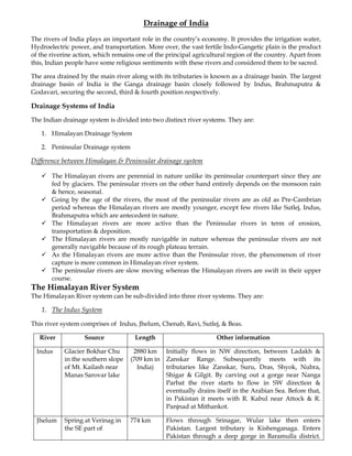
The Himalayan River System
The Himalayan River system can be sub-divided into three river systems. They are:
1. The Indus System
This river system comprises of Indus, Jhelum, Chenab, Ravi, Sutlej, & Beas.
River Source Length Other information
Indus Glacier Bokhar Chu 2880 km Initially flows in NW direction, between Ladakh &
in the southern slope (709 km in Zanskar Range. Subsequently meets with its
of Mt. Kailash near India) tributaries like Zanskar, Suru, Dras, Shyok, Nubra,
Manas Sarovar lake Shigar & Gilgit. By carving out a gorge near Nanga
Parbat the river starts to flow in SW direction &
eventually drains itself in the Arabian Sea. Before that,
in Pakistan it meets with R. Kabul near Attock & R.
Panjnad at Mithankot.
Jhelum Spring at Verinag in 774 km Flows through Srinagar, Wular lake then enters
the SE part of Pakistan. Largest tributary is Kishenganaga. Enters
Pakistan through a deep gorge in Baramulla district.
2. Kashmir Valley Joins Chenab at Trimmu in Pakistan.
Chenab Lahul district, 1180 km Chandra & Bhaga river originates in Lahul District
Himachal Pradesh (HP) near Bara Lacha Pass. Both rivers meets & Tandi
(HP) and flows in between the Pir Panjal & Greater
Himalaya range. Initially flows in NE direction, the
takes a hairpin bend at Kishtwar (HP) and then enters
Pakistan. Later it meets Indus at Mithankot, Pakistan.
Beas Kangra district, 470 km Starts from Rohtang Pass, meets R. Sutlej at Hari-ke-
Himachal Pradesh Pattan, South of Amritsar, Punjab.
(Rohtang Pass)
Ravi Kangra district, 720 km Starts from Rohtang Pass, drains the western slope of
Himachal Pradesh Pir Panjal range & northern slope of Dhauladhar
(Rohtang Pass) range. Enters Pakistan & meets R Chenab at
Ahmedpur Sial.
Sutlej Lake Rakshatal in 1550 km Also known as Red river. It enters India through
Tibet near Manas Shipki La in Himachal Pradesh. Meets with Beas at
Sarovar Hari-ke-Pattan.
Multipurpose Projects/ Dams:
a) Baglihar Project on R. Chenab in Doda District, Kashmir. The project is financed by World
Bank. The project is a controversial one as Pakistan claimed that construction of the dam
violated the Indus Water Treaty. Other notable dams on Chenab are Salal, Dulhasti, Sawalkot,
Kirthai, & Pakal-Dul dams.
b) Mangla Dam on Jhelum river is the 6th largest dam in the world. It was built in 1961 -67
according to the Indus Basin project that resulted out of Indus Water Treaty. This dam is
situated in Mirpur District of Azad Kashmir. Apart from this there is Uri HEP (Baramulla
dist.)on River Jhelum
c) Chamera Dam (Chamba, HP), Baira-Siul Dam (Chamba, HP)and Ranjeet Sagar Dam (Punjab)
on R. Ravi.
d) Bhakra-Nangal project and Nathpa Dam (HP) on R. Sutlej.
e) Pong Dam (Kangra, HP) & Pandoh (Mandi, HP)Dam on R. Beas.
f) Tarbela Dam on R.Indus at Haripur in Pakistan, which was built in 1974 as a part of Indus
Basin Project.
2. The Brahmaputra System
The Brahmaputra river is one if the major rivers if South Asia. It is 2900km long and rises from the
glaciers near Manas Sarovar Lake. In Tibet it is known as Yarlung Tsangpo. It enter India through a
deep gorge near Namcha Barwa. From here onwards the River is known as Brahmaputra. R.
Brahmaputra travels south ward till Sadiya, from where it takes a sharp bend flows in western
direction through Assam valley. It flows westward up to Dhubri from where it again takes a sharp
bend and starts to flow southward, thus flowing into Bangladesh. In Bangladesh the river get
divided into two branches: Jamuna & old Brahmaputra. This two river again meets as Chandpur in
Bangladesh & eventually falls in Bay of Bengal.
River Brahmaputra is known for its annual flood. The causes behind this annual flood are:
The large amount of rainfall in the catchment area.
Sudden debouchment of sediments in the Assam valley from the Himalayas due the drastic
change in channel gradient.
3. The important tributaries of R. Brahmaputra are:
Left bank tributaries: Dhansiri, Kapili, Barak
Right bank tributaries: Subansiri, Jia Bhoraeli, Manas, Sankosh, Tista & Raidak
a. Dhansiri: Rises from Naga hills
b. Sankosh: It’s the main river of Bhutan, meets Brahmaputra at Dhubri, Assam.
c. Manas: Rises from Tibet and joins Brahmaputra on its right bank.
d. Subansiri: It is flows in between the Mikir hills & Abor hills and later joins Brahmaputra on its
right bank.
e. Tista: Rises from Kanchanjunga, fed by the tributaries like Rangit & Rangpo, it joins the
Brahmaputra river in Bangladesh.
f. Barak: Rises from Mt. Japov in Nagaland. It enters Bangladesh as R. Surma which falls into R.
Padma at Chandpur.
3. The Ganga System
River Source Length Other Information
Ganga Gamukh Glacier, 2510 Initially it is know as Bhagirathi. It meets with
Uttar Kashi District km Alakananda at Devaprayag and from here it is known
of Uttrakhand as Ganga. The river enters the plain land from
Hardwar. From Hardwar onwards it flows in SE
direction in UP and in eastern direction in Bihar. When
the river enters the Maldah district of WB it get
divided into two branches: Hooghly & Padma. The
flows into the WB & Padma enters Bangladesh.
Yamuna Yamunotri Glacier, 1380 It meets Ganga at Allahabad.
Uttarakhand km
Chambal Malwa Plateau, 960 km Main tributaries are Banas, Kali Sind, Shipra & Parbati.
Vindhyan Range Meets with Yamuna at the boundary of Bhind &
Etawah district of MP.
Ghagra Gurla Mandhata - In Nepal it is known as Karnali river. Meets River
peak in Nepal Ganga at Chhapra.
Gandak Between Dhaulagiri - It enters India through Champaran district, Bihar.
& Mt. Everest Meets Ganga at Sonpur near Patna
Son Amarkantak Plateau, 780 km It meets R. Ganga at Bankipora near Patna.
MP
Mahananda Darjeeling Hills, WB -
Kosi Southern slope of Mt. 729 km Enters India through the Chhatra & Saharsa district of
Everest Bihar and joins R. Ganga near Manihari in Bihar. Also
known as Sorrow of Bihar.
Damodar Chandwa Village, 592 km It meets R. Ganga at Falta (South 24 PGS)
Palamau district,
Jharkand
4. Multipurpose Projects/ Dams:
a) Bansagar Dam & Indrapuri Barrage on River Son.
b) Gandhi Sagar Dam, Rana Pratap Sagar Dam & Jawahar Sagar Dam on River Chambal.
c) Tehri Dam on Bhagirathi River
d) Farakka Barrage on R. Ganga
e) Panchet Dam on R. Damodar.
The Peninsular River System
River Source Length Other Information
Godavari Brahmagiri 1465 km Also know as ‘Vriddha’ Ganga. Important left bank
Mountain, tributaries are Purna, Maner, Penganga, Pranhita
Trimbakeswar, (formed by the meeting of Wardha & Wainganaga),
Nasik, Maharastra Indravati, Tal & Sabri. Important right bank tributary
is Manjira. The river near Rajamundhry get divided
into two Channels Vasistha & Gautami and forms one
of the largest delta in India. Lake Kolleru is a lagoon
within the deltaic region of Godavari.
Krishna Mahabaleshwar, 1290 km Left bank tributaries are Bhima, Dindi, Musi &
Maharastra Munneru. Right bank tributaries are Ghataprabha,
Tungabhadra, Panchganga and Koyna. The Krishna
delta is a birdfoot delta.
Cauvery Kodagu district, 765 km Important tributaries are Shimsha, Bhavani and
Karnataka Moyar. It is considered as sacred river and often
called as Ganga of the south.
Mahanadi Dhamtari district, 885 km Notable tributaries are Seonath, Telen, Sandur & Ib.
Chattisgarh Falls in Bay of Bengal, forming a delta.
Brahmani Formed by the 420 km Seasonal river, flowing through the districts of
confluence of Sundargarh, Keonjhar, Dhenkanal, Cuttack & Jajapur.
Sankh & South
Koel
Tapi Satpura Range, 700 km It flows through Maharastra, Madhya Pradesh &
MP Gujrat. Important tributaries are Purna, Girna and
Panzara.
Narmada Amarkantak 1300 km It flows through a rift valley between Vindhya &
plateau, Anuppur Satpura. It travels westward and empties itself into
district, MP the Gulf of Khambat.
Luni Aravalli Range, 530 km It drains the western flank of Aravalli hills, where it is
Ajmer, Rajasthan known as Sagarmati. The major tributaries are Sukri,
Bandi & Jawai. It get disappeared into the Rann of
Kutch after flowing in SW direction for about 500 km.
Mahi Udaipur district, 500 km It flows in SW direction through Dungarpur &
Rajasthan (approx) Banswara district of Rajasthan and finally empties
itself in Gulf of Khambat.
5. Multipurpose Projects/ Dams:
a) Doleswar Barrage, Sriram Sagar Reservoir, Polavaram Dam, Trimbakeswar dam & Jayakwadi
Dam on R. Godavari. Nizam Sagar Reservoir on Manjira river (tributary of Godavari)
b) Joorala reservoir, Nagarjuna Sagar dam, Prakasham Barrage, Alamatti Dam & Srisailam Dam
on R. Krishna. Osman Sagar reservoir on R. Musi (tributary of Krishna). Dhupdal reservoir &
Hidkal reservoir on R. Ghataprabha (tributary of Krishna)
c) Bargi Dam, Kolar dam, Omkareshwar Multi purpose project, Sardar Sarovar project &
Indirasagar project on R. Narmada.
d) Hirakud Dam on R. Mahanadi.
e) Krishna Raja Sagar dam & Mettur dam on Cauvery river. Banasura Sagar Dam on Kabini river
(tributary of R. Cauvery)
f) Rengali Dam on Brahmani river
Indian River Linking Project (IRLP): An Assessment
The recent controversy regarding the Indian River Linking Project (IRLP) reflects the dichotomy of the
Commercial Approach and Ecological Approach of the people towards river. The fabrication of IRLP
primarily recognizes the need of utilizing the river water equally in different parts of the country. As
far as our country is concerned, some river basin experiences surplus water whereas some experiences
deficit. Formulation of IRLP revolves round the idea of interconnecting the rivers of the country in
order to balance out the surplus and deficit river water supply.
The Historical Overview of IRLP:
The idea of IRLP was first proposed by Sir Arthur Cotton in 1839. At that time the main motive behind
the formulation of such mammoth plan was to connect the various places of India through waterways.
It was believed to be a strategic plan of the British Rule to minimize the cost of roadways construction.
In recent times the issue of IRLP was again raised by the then Indian Water Minister, Dr, K. L. Rao in
1972 and by Capt. Dastur through his Garland Canal project in 1974.
However, the Indian River Linking Project experienced a revival in 2002, by the then Indian President
Dr. A. P. J. Abdul Kalam, in his speech on the eve of Indian Independence Day. The controversy was
lighted up by PIL (Public Litigation File) filed in Supreme Court by Ranjit Kumar, a Supreme Court
advocate against IRLP. A directive was passed by the court for the realization of the IRLP, within 2016.
Subsequently, the then NDA Government formulated a taskforce to implementation of the project.
With the emergence of the new UPA Government in 2005, the taskforce was replaced and a review of
the Indian River Linking Project (IRLP) was promised.
The Plan: IRLP
The total river linking project is believed to have two broad sections:
o The Peninsular Component
o The Himalayan Component
The Peninsular Component comprises of 16 links. They are:
1. Mahanadi (Manibhadra) –Godavari (Dowlaiswaram) Link
2. Godavari (Polavarm) –Krishna (Vijayawada) Link
3. Godavari (Inchamaplli) –Krishna(Nagarjunasagar) Link
6. 4. Godavari (Inchampally Low Dam) –Krishna (Nagarjunasagar Tail Pond)
5. Krishna (Nagarjunasagar) –Pennar (Somasila) Link
6. Krishna (Srisailam) –Pennar Link
7. Krishna (Almatti) –Pennar Link
8. Pennar (Somasila) –Cauvery (Grand Anicut) Link
9. Cauvery (Kattalai) –Vaigai (Gundar) Link
10. Parbati –Kalishindh –Chambal Link
11. Damanganga –Pinjal Link
12. Par-Tapi –Narmada Link
13. Ken –Betwa Link
14. Pamba –Achankovil –Vaippar Link
15. Netrreavati –Hemavati Link
16. Bedti –Varda Link
The Himalayan Component on the other hand consists of 14 links. They are:
1. Kosi –Mechi Link
2. Kosi –Ghaghra Link
3. Gandak –Ganga Link
4. Ghaghra –Yamuna Link
5. Sarda –Yamuna Link
6. Yamuna –Rajasthan Link
7. Rajasthan –Sabarmati Link
8. Chunar –Sone Barrage Link
9. Sone Dam –Southern Tributaries of Ganga Link
10. Brahmaputra –Ganga Link (Manas-SankoshTista-Ganga)
11. Brahmaputra-Ganga Link (Jogighopa Tista-Farakka)
12. Farakka –Sunderbans Link
13. Ganga –Damodar –Sundernarekha Link
14. Subernarekha –Mahanadi Link
Apart from this, the plan also envisages the construction of 30 large dams, reservoirs and canals, which
will act as a ‘lift’ to carry the links against the gravity.
Storms of Criticism: IRLP
(i) Erroneous Basic Premise. IRLP’s basic premise, according to which certain river basins are surplus
while others are deficit is unsound, because each river, over geological eons, has given rise to a specific
eco-system and culture in its basin. Specific to its eco-system and culture, a particular river’s water is
neither ‘surplus’ nor ‘deficit.’ Any large scale transfer of water from one basin to another cannot but
irreparably affect the eco-systems of both the basins.
(ii) Faulty Concepts. The concepts of ‘surplus’ and ‘deficit’ are relative and not absolute. In particular,
they depend on demand and supply side conditions
(iii) Doubtful Financial Feasibility. Even if all the engineering might is marshaled and the proposed dams
– barrages – reservoirs – lifts – tunnels – canals are actually built, the benefits of the project may not
justify the financial costs.
7. (iv) Doubtful Flood Mitigation. IRLP’s flood mitigation effects are doubtful too. Flood mitigation through
inter-basin transfer in South Asia is made difficult by the fact that the months of heavy precipitation
(from south-westerly monsoon winds) are basically the same for all parts of the region
(vi) Irreparable Ecological Damage and Other Non-economic Costs: The benefits of IRLP will certainly fall
short of the costs if the damage done to the eco-systems and cultures and other non-economic costs of
the project are taken into consideration.
(vii) Exacerbation of Conflicts: IRLP will proliferate and aggravate inter-state conflicts that already exist
within India over river-sharing. More importantly, IRLP will aggravate conflicts among co-riparian
countries of South Asia. Water diversion from the Ganges by India at Farakka is already an important
obstacle to improving the relationships between India and Bangladesh.
(viii) Unintended Consequences and Possible Redundancy. A major river-intervention project such as IRLP
cannot but have many unintended consequences of negative nature. Many of the dams and reservoirs
of IRLP are to be built in seismically active regions of South Asia. The Indian Ocean earthquake of
December 2004 gives some indication of the terrible consequences that may follow if dams of IRLP
crumble under the impact of earthquakes. More importantly, climate changes resulting from global
warming and other such processes can soon make IRLP’s calculations obsolete.