This document summarizes a book about comparative views, which were maps from the 19th century that showed geographical features like mountains and rivers side-by-side to compare their sizes. It describes how these views evolved from imaginary landscape images inspired by Alexander von Humboldt to more graph-like diagrams. The book examines examples of different styles of comparative views from 1805 to 1860 and discusses how they reflected changing world knowledge and ideals of data visualization before disappearing by the 20th century.

![Contents
Introduction 1
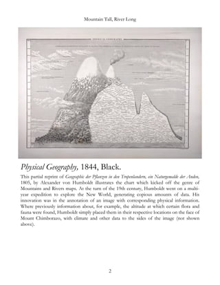
Physical Geography, 1844, Black. 2
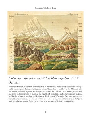
Höhen der alten und neuen Welt bildlich verglichen, c1810,
Bertuch.
3
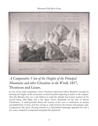
A Comparative View of the Heights of the Principal Mountains and
other Elevations in the World, 1817, Thomson and Lizars.
4
A Map of the Principal Rivers Shewing their Courses, Countries,
and Comparative Lengths, 1834, SDUK.
5
A Comparative View of the Principal Waterfalls, Islands, Lakes,
Rivers, and Mountains of the Western [and] Eastern Hemispheres,
1851, Tallis.
6
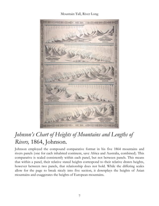
Johnson’s Chart of Heights of Mountains and Lengths of Rivers,
1864, Johnson.
7
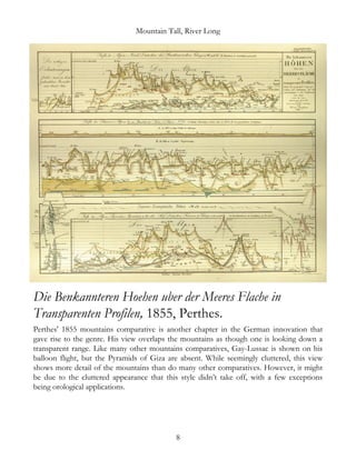
Die Benkannteren Hoehen uber der Meeres Flache in Transparenten
Profilen, 1855, Perthes.
8
The World in Hemispheres with Other Projections, 1860, Mitchell. 9](https://image.slidesharecdn.com/b47b657e-dd2c-49d6-9aa3-5036faf3cf55-160528114534/85/Mountain-Tall-River-Long-eBook-5-320.jpg)

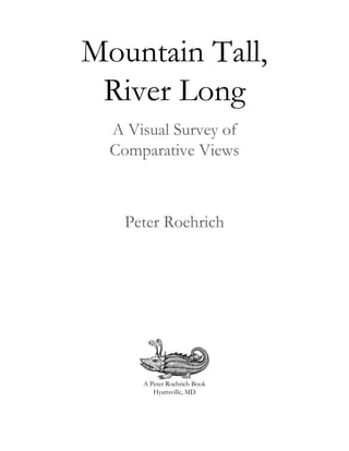
![Mountain Tall, River Long
A Map of the Principal Rivers Shewing their Courses,
Countries, and Comparative Lengths, 1834, SDUK.
The second quarter of the nineteenth century saw tremendous experimentation in
comparative visualization. Indeed, this era generally saw new forms of graphical data
display. The Society for the Diffusion of Useful Knowledge published this unique radial
diagram where rivers are shown flowing in the direction they do in situ, into an imaginary
central sea. While this format took hold nowhere else, it is a testament to SDUK
cartographers’ creativity in solving the problem of showing rivers flowing in artificial
directions for sake of illustration; indeed, this chart is titled as “shewing [sic] their courses.”
5](https://image.slidesharecdn.com/b47b657e-dd2c-49d6-9aa3-5036faf3cf55-160528114534/85/Mountain-Tall-River-Long-eBook-11-320.jpg)
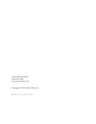
![Mountain Tall, River Long
A Comparative View of the Principal Waterfalls, Islands,
Lakes, Rivers, and Mountains of the Western [and] Eastern
Hemispheres, 1851, Tallis.
In anticipation of the London world exposition in 1851, John Tallis published a stunning
atlas. He is regarded as one of the last cartographers to decorate his works with scrolling
borders, elaborate cartouches, and vignettes; the comparatives from this atlas certainly fit
that description. They are also remarkable for their blending of the early comparative vista
style seen in the waterfalls at the top of the piece, with the later graph-like and compound
arrangement seen in the bottom mountains and rivers panel.
6](https://image.slidesharecdn.com/b47b657e-dd2c-49d6-9aa3-5036faf3cf55-160528114534/85/Mountain-Tall-River-Long-eBook-12-320.jpg)


![[하코사 세미나] 비전공자의 자바스크립트 도전기](https://cdn.slidesharecdn.com/ss_thumbnails/pthacosa3-160525065322-thumbnail.jpg?width=640&height=640&fit=bounds)


![[DCSB] Dr Leif Isaksen "The Practical Prognosticator - On the Use and Abuse o...](https://cdn.slidesharecdn.com/ss_thumbnails/dcsbisaksen05022013-130220041112-phpapp02-thumbnail.jpg?width=640&height=640&fit=bounds)


