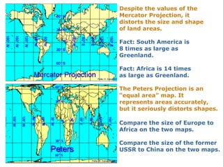
Big Geography 
The Geography of 
Global History
Objective 
• Students will develop a basic 
understanding of world geography in 
order to become more effective global 
thinkers. 
You will achieve this by being able to….. 
1.Explain the differences between the three different world map projections. 
2.List and explain the three different layers of the biosphere. 
3.Define “continent” and locate the 7 continents of the world. 
4.Write a brief paragraph explaining whether or not you think Europe should be a 
continent. 
5.Locate the 5 different seas “inside” Afroeurasia. 
6.Explain the significance of great arid zones and mountain ranges. 
7.Know and be able to locate the 11 seas of Afroeurasia. Also, explain their 
importance. 
8.Understand the relevance of wind and current in regards to world history. 
9.Explain why Afroeurasia, Australia, Americas, Antarctica can be thought of as 
the four continents of the world, and be able to locate them on a map. 
10.Know and be able to locate the great rivers of the world. Also, be able to 
explain there impact on world history.
We need a mental picture of the 
whole world, not just certain parts of 
it. This is “big geography.”
Africa 
South America
Did you know 
that how we 
“see” the 
world depends 
on how we 
project the 
Did you know 
that how we 
“see” the 
world depends 
on how we 
project the 
world? 
world?
The Earth is a sphere. 
Therefore, it cannot be 
projected on a flat map 
without distortion. The 
The Earth is a sphere. 
Therefore, it cannot be 
projected on a flat map 
without distortion. The 
question is, 
question is, 
which kind of distortion? 
which kind of distortion?
Three World Map Projections 
Mercator, Peters, and Robinson
On a Mercator projection, invented by Gerardus Mercator in 
1569, any straight line is a line of constant compass bearing. 
This enables a navigator to plot a straight-line course.
Despite the values of the 
Mercator Projection, it 
distorts the size and shape 
of land areas. 
Fact: South America is 
8 times as large as 
Greenland. 
Fact: Africa is 14 times 
as large as Greenland. 
The Peters Projection is an 
“equal area” map. It 
represents areas accurately, 
but it seriously distorts shapes. 
Compare the size of Europe to 
Africa on the two maps. 
Compare the size of the former 
USSR to China on the two maps.
Human beings inhabit 
the biosphere. 
The biosphere is made up of three layers. 
•The lithosphere: The solid earth, or outer 
crust of rock, sand, and soil. 
•The hydrosphere: The watery realm. About 
97 percent of it is the oceans. 
•The atmosphere: The thin layer of gasses, 
mainly nitrogen and oxygen.
The lithosphere is in constant, 
though slow motion. 
The surface of the 
The surface of the 
earth and the 
earth and the 
location of its land 
masses have 
therefore 
masses have 
therefore 
had a continuously 
changing history. 
had a continuously 
changing history.
The scene of history is continuously moving land masses. 
Notice in the left column the names of distinct land 
masses that no longer exist. 
The red dot represents the location of the Grand Canyon.  
Pangaea 
Laurasia 
Gondwanaland 
India 
South America 
550 Million Years Ago 
220 Million Years Ago 
190 Million Years Ago 
130 Million Years Ago 
65 Million Years Ago 
Today
The largest context of 
human history is the 
entire planet.
70.9 % of the surface of 
the earth is water. 
Human beings, however, 
are a land-dwelling 
species. 
We call the biggest land 
areas continents.
How many continents 
are there? 
Nine? 
One? 
Seven? 
Five? 
Four?
But what IS a 
continent? 
But what IS a 
continent? 
The conventional map of seven continents
Conventional definition of a continent 
A large mass of land surrounded, or nearly 
surrounded, by water. 
If that is the conventional definition, why are 
Europe and Asia separate continents?
Since the nineteenth century, most scholars have 
accepted the Ural Mountains as part of the dividing 
Line between “Europe” and “Asia” as continents. 
The Urals as a border between continents? 
They are not that impressive.
Ural Mts. 
EUROPE 
Another part of the 
dividing line: 
Bosporus and 
Dardanelles 
(Straits) 
ASIA
Bosporus 
Istanbul 
Dardanelles
What significance have the Bosporus and Dardanelles had as 
a line dividing peoples from one another in history? 
Almost 
none! 
Almost 
none!
So, why is Europe a continent? 
European scholars of 
the nineteenth century 
decided that it should 
European scholars of 
the nineteenth century 
decided that it should 
be one. 
be one. 
One of the benefits of 
having power in the 
world is that you get to 
One of the benefits of 
having power in the 
world is that you get to 
name things! 
name things!
The dividing line between 
“Europe” and “Asia” is not 
something that is “natural.” That 
is, it does not exist as a fact of the 
natural world. 
Many geographers have therefore 
been willing to unite the two 
regions as a single continent 
called “Eurasia.”
Asia + Europe = Eurasia 
E U R A S I A
But is Africa separated 
from Eurasia by a wide 
But is Africa separated 
from Eurasia by a wide 
ocean? 
No! 
ocean? 
No! 
Why not think of Eurasia 
and Africa together as a 
single “supercontinent?” 
Let’s call it “Afroeurasia.” 
Why not think of Eurasia 
and Africa together as a 
single “supercontinent?” 
Let’s call it “Afroeurasia.”
Africa + Asia + Europe = Afroeurasia 
A F R O E U R A S I A
Think of Afroeurasia as having some 
seas “inside” it. 
Black Sea 
Caspian Sea 
Mediterranean Sea 
Persian Gulf 
Red Sea 
You figure out 
which is which?
One of the big geographical features of Afroeurasia is 
the Great Arid Zone. This is the belt of arid or semi-arid 
land that extends nearly across Afroeurasia. 
Great Arid Zone
Scenes in 
the Great 
Arid Zone of 
Afroeurasia 
Extreme dryness 
Ahaggar Mts., Sahara Desert 
Semi-aridity 
Grassy steppes of Mongolia
Historically, peoples who herd animals as 
a way of life have inhabited many parts of 
the Great Arid Zone. These herders are 
pastoral nomads, that is, they move with 
their herds or flocks from pasture to 
pasture. 
Herders in Mongolia
A major theme in world history has been 
the dynamic relations between pastoral 
nomadic peoples of the Great Arid Zone… 
…and peoples who 
have been farmers 
or city-dwellers.
Nomadic peoples of the 
Great Arid Zone both 
traded and clashed with 
farming and city-dwelling 
peoples who lived adjacent 
to the Great Arid Zone. 
One of the greatest clashes 
was the attacks of Mongol 
nomads on cities of Eurasia 
Nomadic peoples of the 
Great Arid Zone both 
traded and clashed with 
farming and city-dwelling 
peoples who lived adjacent 
to the Great Arid Zone. 
One of the greatest clashes 
was the attacks of Mongol 
nomads on cities of Eurasia 
in the 13th century. 
in the 13th century.
Another feature of big geography is 
the earth’s great mountain chains 
Mountains have been barriers to human communication. 
But passes across them have also served as 
“valves” of communication.
2 
3 
The Eleven Seas of Afroeurasia 
They made it easier for people to 
communicate by water across Afroeurasia. 
4 
5 
6 
8 9 
10 
11 
7 
1 
Name 
these 
seas! 
Name 
these 
seas!
Before modern times, 
merchants relayed goods 
from one link in the “chain 
of seas” to another. That 
is, a single merchant did 
not make the trip from one 
end of the chain to the 
other, though it was 
theoretically possible.
The major winds and currents of the oceans 
Until the coming of steamships in the 19th century, sailors had to know 
winds and currents to have confidence that they could sail from one 
place to another in an approximate amount of time. These winds 
and currents follow large global patterns. It was a matter of 
discovering what those patterns were. 
winter 
summer 
Indian Ocean 
Monsoon Winds
The wind cycle in the North Atlantic helped 
Christopher Columbus sail both ways 
across the ocean. 
WIND 
WIND
So, how many continents? 
• Afroeurasia 
• Australia 
• North America 
• South America 
• Antarctica 
• Afroeurasia 
• Australia 
• Americas 
• Antarctica 
But is it possible to 
think of North and 
South America as ONE 
But is it possible to 
think of North and 
South America as ONE 
continent? 
continent?
Are the 
Americas 
one 
continent 
Troy rt ot wthoin?k of 
the Gulf of 
Mexico and 
the 
Caribbean 
Sea as bodies 
of water 
“inside” 
the Americas. 
Gulf of 
Mexico 
Caribbean 
Sea
Finally, let’s not forget great rivers. They have 
served as channels of communication between 
seas and deep interior lands. 
Columbia 
Mississippi 
Niger 
Danube 
Indus Ganges 
Nile Tigris- 
Amazon Congo 
Euphrates 
Yellow 
(Huang) 
Yangze 
Mekong 
Darling- 
Murray 
Finally, let’s not forget great rivers. They have 
served as channels of communication between 
seas and deep interior lands.

Big Geography - Overview Presentation

  • 1.
    Big Geography TheGeography of Global History
  • 2.
    Objective • Studentswill develop a basic understanding of world geography in order to become more effective global thinkers. You will achieve this by being able to….. 1.Explain the differences between the three different world map projections. 2.List and explain the three different layers of the biosphere. 3.Define “continent” and locate the 7 continents of the world. 4.Write a brief paragraph explaining whether or not you think Europe should be a continent. 5.Locate the 5 different seas “inside” Afroeurasia. 6.Explain the significance of great arid zones and mountain ranges. 7.Know and be able to locate the 11 seas of Afroeurasia. Also, explain their importance. 8.Understand the relevance of wind and current in regards to world history. 9.Explain why Afroeurasia, Australia, Americas, Antarctica can be thought of as the four continents of the world, and be able to locate them on a map. 10.Know and be able to locate the great rivers of the world. Also, be able to explain there impact on world history.
  • 3.
    We need amental picture of the whole world, not just certain parts of it. This is “big geography.”
  • 4.
  • 5.
    Did you know that how we “see” the world depends on how we project the Did you know that how we “see” the world depends on how we project the world? world?
  • 6.
    The Earth isa sphere. Therefore, it cannot be projected on a flat map without distortion. The The Earth is a sphere. Therefore, it cannot be projected on a flat map without distortion. The question is, question is, which kind of distortion? which kind of distortion?
  • 7.
    Three World MapProjections Mercator, Peters, and Robinson
  • 8.
    On a Mercatorprojection, invented by Gerardus Mercator in 1569, any straight line is a line of constant compass bearing. This enables a navigator to plot a straight-line course.
  • 9.
    Despite the valuesof the Mercator Projection, it distorts the size and shape of land areas. Fact: South America is 8 times as large as Greenland. Fact: Africa is 14 times as large as Greenland. The Peters Projection is an “equal area” map. It represents areas accurately, but it seriously distorts shapes. Compare the size of Europe to Africa on the two maps. Compare the size of the former USSR to China on the two maps.
  • 10.
    Human beings inhabit the biosphere. The biosphere is made up of three layers. •The lithosphere: The solid earth, or outer crust of rock, sand, and soil. •The hydrosphere: The watery realm. About 97 percent of it is the oceans. •The atmosphere: The thin layer of gasses, mainly nitrogen and oxygen.
  • 11.
    The lithosphere isin constant, though slow motion. The surface of the The surface of the earth and the earth and the location of its land location of its land masses have therefore masses have therefore had a continuously changing history. had a continuously changing history.
  • 12.
    The scene ofhistory is continuously moving land masses. Notice in the left column the names of distinct land masses that no longer exist. The red dot represents the location of the Grand Canyon.  Pangaea Laurasia Gondwanaland India South America 550 Million Years Ago 220 Million Years Ago 190 Million Years Ago 130 Million Years Ago 65 Million Years Ago Today
  • 13.
    The largest contextof human history is the entire planet.
  • 14.
    70.9 % ofthe surface of the earth is water. Human beings, however, are a land-dwelling species. We call the biggest land areas continents.
  • 15.
    How many continents are there? Nine? One? Seven? Five? Four?
  • 16.
    But what ISa continent? But what IS a continent? The conventional map of seven continents
  • 17.
    Conventional definition ofa continent A large mass of land surrounded, or nearly surrounded, by water. If that is the conventional definition, why are Europe and Asia separate continents?
  • 18.
    Since the nineteenthcentury, most scholars have accepted the Ural Mountains as part of the dividing Line between “Europe” and “Asia” as continents. The Urals as a border between continents? They are not that impressive.
  • 19.
    Ural Mts. EUROPE Another part of the dividing line: Bosporus and Dardanelles (Straits) ASIA
  • 20.
  • 21.
    What significance havethe Bosporus and Dardanelles had as a line dividing peoples from one another in history? Almost none! Almost none!
  • 22.
    So, why isEurope a continent? European scholars of the nineteenth century decided that it should European scholars of the nineteenth century decided that it should be one. be one. One of the benefits of having power in the world is that you get to One of the benefits of having power in the world is that you get to name things! name things!
  • 23.
    The dividing linebetween “Europe” and “Asia” is not something that is “natural.” That is, it does not exist as a fact of the natural world. Many geographers have therefore been willing to unite the two regions as a single continent called “Eurasia.”
  • 24.
    Asia + Europe= Eurasia E U R A S I A
  • 25.
    But is Africaseparated from Eurasia by a wide But is Africa separated from Eurasia by a wide ocean? No! ocean? No! Why not think of Eurasia and Africa together as a single “supercontinent?” Let’s call it “Afroeurasia.” Why not think of Eurasia and Africa together as a single “supercontinent?” Let’s call it “Afroeurasia.”
  • 26.
    Africa + Asia+ Europe = Afroeurasia A F R O E U R A S I A
  • 27.
    Think of Afroeurasiaas having some seas “inside” it. Black Sea Caspian Sea Mediterranean Sea Persian Gulf Red Sea You figure out which is which?
  • 28.
    One of thebig geographical features of Afroeurasia is the Great Arid Zone. This is the belt of arid or semi-arid land that extends nearly across Afroeurasia. Great Arid Zone
  • 29.
    Scenes in theGreat Arid Zone of Afroeurasia Extreme dryness Ahaggar Mts., Sahara Desert Semi-aridity Grassy steppes of Mongolia
  • 30.
    Historically, peoples whoherd animals as a way of life have inhabited many parts of the Great Arid Zone. These herders are pastoral nomads, that is, they move with their herds or flocks from pasture to pasture. Herders in Mongolia
  • 31.
    A major themein world history has been the dynamic relations between pastoral nomadic peoples of the Great Arid Zone… …and peoples who have been farmers or city-dwellers.
  • 32.
    Nomadic peoples ofthe Great Arid Zone both traded and clashed with farming and city-dwelling peoples who lived adjacent to the Great Arid Zone. One of the greatest clashes was the attacks of Mongol nomads on cities of Eurasia Nomadic peoples of the Great Arid Zone both traded and clashed with farming and city-dwelling peoples who lived adjacent to the Great Arid Zone. One of the greatest clashes was the attacks of Mongol nomads on cities of Eurasia in the 13th century. in the 13th century.
  • 33.
    Another feature ofbig geography is the earth’s great mountain chains Mountains have been barriers to human communication. But passes across them have also served as “valves” of communication.
  • 34.
    2 3 TheEleven Seas of Afroeurasia They made it easier for people to communicate by water across Afroeurasia. 4 5 6 8 9 10 11 7 1 Name these seas! Name these seas!
  • 35.
    Before modern times, merchants relayed goods from one link in the “chain of seas” to another. That is, a single merchant did not make the trip from one end of the chain to the other, though it was theoretically possible.
  • 36.
    The major windsand currents of the oceans Until the coming of steamships in the 19th century, sailors had to know winds and currents to have confidence that they could sail from one place to another in an approximate amount of time. These winds and currents follow large global patterns. It was a matter of discovering what those patterns were. winter summer Indian Ocean Monsoon Winds
  • 37.
    The wind cyclein the North Atlantic helped Christopher Columbus sail both ways across the ocean. WIND WIND
  • 38.
    So, how manycontinents? • Afroeurasia • Australia • North America • South America • Antarctica • Afroeurasia • Australia • Americas • Antarctica But is it possible to think of North and South America as ONE But is it possible to think of North and South America as ONE continent? continent?
  • 39.
    Are the Americas one continent Troy rt ot wthoin?k of the Gulf of Mexico and the Caribbean Sea as bodies of water “inside” the Americas. Gulf of Mexico Caribbean Sea
  • 40.
    Finally, let’s notforget great rivers. They have served as channels of communication between seas and deep interior lands. Columbia Mississippi Niger Danube Indus Ganges Nile Tigris- Amazon Congo Euphrates Yellow (Huang) Yangze Mekong Darling- Murray Finally, let’s not forget great rivers. They have served as channels of communication between seas and deep interior lands.

Editor's Notes

  • #2 NASA Big Blue Marble Images http://rsd.gsfc.nasa.gov/rsd/bluemarble/index.html
  • #4 Cartoon source unknown. If you know the source, please share with Director, World History for Us All, http://worldhistoryforusall.sdsu.edu.
  • #7 http://bestanimations.com/Earth&Space/Earth/Earth6.html
  • #8 Copyright © 1999 Peter H. Dana, Department of Geography, University of Texas at Austin, 1995. The Geographer's Craft Project, Department of Geography, The University of Colorado. Http://www.colorado.edu/geography/gcraft/notes/mapproj/mapproj_f.html .
  • #9 Any straight line on a Mercator-projection map is a line of constant true bearing that enables a navigator to plot a straight-line course.
  • #10 Land area of Alaska: 615, 230 sq. miles. Land area of Texas: 267, 277 sq. miles. Texas is 43% of the size of Alaska.
  • #13 Source: Grand Canyon Explorer www.kaibab.org Copyright Bob Ribokas
  • #17 http://members.eb.com/world/continents-world.html Encyclopedia Britannica on-line
  • #18 http://members.eb.com/world/continents-world.html Encyclopedia Britannica on-line
  • #19 Left: www.peakware.com/encyclopedia/peaks/photo Right: Encarta Encyclopedia
  • #22 http://members.eb.com/world/continents-world.html Encyclopedia Britannica on-line
  • #25 http://members.eb.com/world/continents-world.html Encyclopedia Britannica on-line
  • #27 http://members.eb.com/world/continents-world.html Encyclopedia Britannica on-line
  • #28 http://members.eb.com/world/continents-world.html Encyclopedia Britannica on-line
  • #29 ttp://images.google.com/imgres?imgurl=http://green.nationalgeographic.com/staticfiles/NGS/Shared/StaticFiles/Environment/Images/Habitat/Desert/map-world-desert-580.jpg&imgrefurl=http://green.nationalgeographic.com/environment/habitats/desert-map.html&h=347&w=580&sz=41&hl=en&start=2&um=1&tbnid=2gS32Ce0oSTqTM:&tbnh=80&tbnw=134&prev=/images%3Fq%3Dworld%2Bdeserts%26svnum%3D10%26um%3D1%26hl%3Den%26client%3Dsafari%26rls%3Den-us%26sa%3DX
  • #30 Horses on Steppe Virtual Mongolia http://www.kiku.com/electric_samurai/virtual_mongol/index.html
  • #34 The New Encyclopaedia Britannica, 15th Ed., 1988, v. 25, p. 139.
  • #35 1. Baltic Sea 2. North Sea 3. Northeastern Coastal Atlantic 4. Mediterranean Sea 5. Red Sea 6. Persian Gulf 7. Arabian Sea 8. Bay of Bengal 9. South China Sea 10. East China Sea 11. Sea of Japan
  • #37 The New Encyclopaedia Britannica, 15th Ed., 1988, v. 25, p. 139.
  • #38 The New Encyclopaedia Britannica, 15th Ed., 1988, v. 25, p. 139.