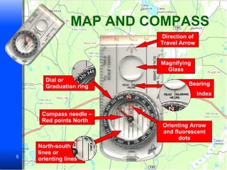
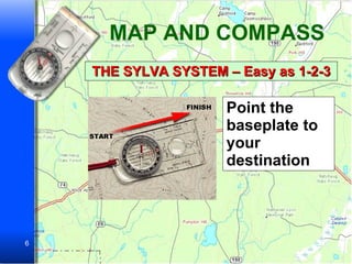
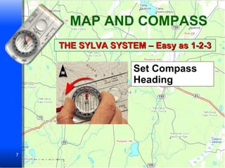
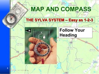
MAP AND COMPASS Learning the Basics
MAP AND COMPASS Where things are and how to get to them Describe the shape of the land Define and locate natural and man made features Distance between two places Direction from one point to another Topographic Maps
MAP AND COMPASS Primary highway Secondary highway Light-duty road Unimproved road Trail Railroad: single track Railroad: double track Bridge Tunnel Footbridge Overpass - Underpass Buildings School -- church Woodland Orchard Scrub Well water – spring Rapids March (swamp) Falls TOPOGRAPHIC MAP SYMBOLS
MAP AND COMPASS Map Problem It’s July.  Let’s suppose you’re starting a hike at A and heading for Q. PROBLEM 1. For local information or in case of emergency would you go to B, C, or D? Why? ANSWER 1. C has telephone lines next to it.  B is a school and probably closed in summer. D is a cemetery. PROBLEM 2.The Wahootchee River flows NW to SE. To paddle downstream, would it be safer to launch canoes at E or F. Why? ANSWER 2. Launch them at F. The map shows rapids between E and F. PROBLEM 3.Would you cross the river at G or H? Why? ANSWER 3. Use the footbridge at G. H is a railroad bridge. PROBLEM 4. Where would you most likely find firewood – I or U? Why? ANSWER 4. At I. Because I is scrub woods. U is an orchard Problem 5. Which trail would you take – J or K?  Why? ANSWER 5. K.  J goes through a swamp. PROBLEM 6. Which is the easier way to reach P – Trail L or M?  Why? ANSWER 6. The closer contour lines of M show a steeper climb.
MAP AND COMPASS Direction of Travel Arrow Magnifying Glass Bearing  Index Orienting Arrow and fluorescent dots North-south lines or orienting lines Compass needle – Red points North Dial or Graduation ring
MAP AND COMPASS THE SYLVA SYSTEM – Easy as 1-2-3 Point the baseplate to your destination
MAP AND COMPASS THE SYLVA SYSTEM – Easy as 1-2-3 Set Compass Heading
MAP AND COMPASS THE SYLVA SYSTEM – Easy as 1-2-3 Follow Your Heading
MAP AND COMPASS

Map And Compass

  • 1.
    MAP AND COMPASSLearning the Basics
  • 2.
    MAP AND COMPASSWhere things are and how to get to them Describe the shape of the land Define and locate natural and man made features Distance between two places Direction from one point to another Topographic Maps
  • 3.
    MAP AND COMPASSPrimary highway Secondary highway Light-duty road Unimproved road Trail Railroad: single track Railroad: double track Bridge Tunnel Footbridge Overpass - Underpass Buildings School -- church Woodland Orchard Scrub Well water – spring Rapids March (swamp) Falls TOPOGRAPHIC MAP SYMBOLS
  • 4.
    MAP AND COMPASSMap Problem It’s July. Let’s suppose you’re starting a hike at A and heading for Q. PROBLEM 1. For local information or in case of emergency would you go to B, C, or D? Why? ANSWER 1. C has telephone lines next to it. B is a school and probably closed in summer. D is a cemetery. PROBLEM 2.The Wahootchee River flows NW to SE. To paddle downstream, would it be safer to launch canoes at E or F. Why? ANSWER 2. Launch them at F. The map shows rapids between E and F. PROBLEM 3.Would you cross the river at G or H? Why? ANSWER 3. Use the footbridge at G. H is a railroad bridge. PROBLEM 4. Where would you most likely find firewood – I or U? Why? ANSWER 4. At I. Because I is scrub woods. U is an orchard Problem 5. Which trail would you take – J or K? Why? ANSWER 5. K. J goes through a swamp. PROBLEM 6. Which is the easier way to reach P – Trail L or M? Why? ANSWER 6. The closer contour lines of M show a steeper climb.
  • 5.
    MAP AND COMPASSDirection of Travel Arrow Magnifying Glass Bearing Index Orienting Arrow and fluorescent dots North-south lines or orienting lines Compass needle – Red points North Dial or Graduation ring
  • 6.
    MAP AND COMPASSTHE SYLVA SYSTEM – Easy as 1-2-3 Point the baseplate to your destination
  • 7.
    MAP AND COMPASSTHE SYLVA SYSTEM – Easy as 1-2-3 Set Compass Heading
  • 8.
    MAP AND COMPASSTHE SYLVA SYSTEM – Easy as 1-2-3 Follow Your Heading
  • 9.